University of Minnesota
http://www.umn.edu/
612-625-5000
http://www.umn.edu/
612-625-5000
Minnesota Biodiversity Atlas
Bell Museum
Dataset: MIN-Plants
Taxa: Memecylaceae
Search Criteria: excluding cultivated/captive occurrences
1
Page 1, records 1-27 of 27
Bell Museum plants | |
 MIN:Plants | Mouriri NULL 488155[]Weiblen, G.D. GW15082001-11-02 Brazil, Kilometer 41, -1.5 -46.166667, 4m |
MIN:Plants |  Mouriri tessmannii Markgraf 908374[1001867]Gudino, Edgar 1271989-11-03 Ecuador, Napo, Canton Orellana. Sector Huashito, 20 km al norte de Coca. Propiedad de Palmoriente.;;;;, -0.3333333 -77.0833333, 250m |
MIN:Plants |  Mouriri angulicosta Morley 514314[1001828]Morley, T. 11561966-11-21 Brazil, Amazonas, Reserva Florestal Ducke NE of Manaus |
MIN:Plants |  Mouriri arenicola Morley 516105[1001829]Araujo, D. 83351987-12-10 Brazil, Rio de Janeiro, Mun. Cabo Frio |
MIN:Plants |  Mouriri torquata Morley 519108[1001832]Rodrigues, W. 85891969-00-00 Brazil, Amazonas, Manaus, estr. Manaus-Itacoatiara, km 64 |
MIN:Plants |  Mouriri dimorphandra Morley 899034[1001856]Prance, G.T. 90501968-12-17 Brazil, Amazonas, vicinity of Manaus
Reserva Florestal Walter Egler, road Manaus-Itacoatiara, km. 64 |
MIN:Plants |  Mouriri duckeanoides Morley 516107[1001857]Prance, G.T. 30421966-11-10 Brazil, Amazonas, Manaus and vicinity
Road Manaus-Caracarai, km. 28 |
MIN:Plants |  Mouriri megasperma Morley 514315[1001858]Vieira, J. 721950-09-00 Brazil, Espirito Santo, Norte do Rio Doce - Mata S. Gabriel |
MIN:Plants |  Mouriri monopora Morley 516110[1001861]Froes, R.L. 238821949-01-11 Brazil, Amazonas, Igarapé Jandiatuba |
MIN:Plants |  Mouriri obtusiloba Morley 441046[1001863]Oliveira, E. 18281961-08-24 Brazil, Goias, Goiás; Igarapé Uciricaca, regiao de Araguatins |
MIN:Plants |  Mouriri osaensis Morley 518877[1001864]Poveda, L.T. s.n.1975-09-19 Costa Rica, Huesillo o Quiebracho. Llorona - Peninsula de Osa |
MIN:Plants |  Mouriri panamensis Morley 676476[1001865]Duke, J.A. 152261968-02-17 Panama, Panama, Cerro Jefe, near Rio Indio, 671m |
MIN:Plants |  Mouriri papillosa Morley 676475[1001866]Liesner, R. 116161981-04-30 Venezuela, Tachira, Táchira; 10 (airline) km E of La Fundación, 600 - 900m |
MIN:Plants | 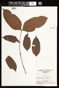 Mouriri retentipetala Morley 926159[1127681]Lleras, E. P169801973-08-01 Brazil, Amazonas, Rio Javari, behind Palmeiras Army Post |
MIN:Plants | 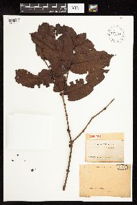 Mouriri sideroxylon Sagot ex Triana 927481[1127682]Sagot 9211888-00-00 French Guiana, "Karouamy" ? |
MIN:Plants | 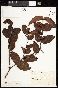 Mouriri uncitheca Morley & Wurdack 79253[1127683]Maguire, B. 355701953-04-14 Venezuela, Rio Guiania. Edge of Sabana El Venado on left bank of Cano Pimichin above Pimichin, 140m |
MIN:Plants | 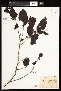 Mouriri vernicosa Naudin 442579[1127684]Marin 0000-00-00 French Guiana, Cayenne |
MIN:Plants |  Mouriri bahiensis Morley 516106[1001830;1001831]Almeida, J. 1601968-10-16 Brazil, Bahia, Bahi; Itabuna
Ba. 8 km S de Itacaré |
MIN:Plants |  Mouriri micranthera Morley 516108[1001859;1001860]I. Cabrera, R. 4631961-04-04 Colombia, Dept. Valle: Bajo Calina |
MIN:Plants |  516112[1001862]Maguire, B. 361351953-11-10 Venezuela, Amazonas, Great Rapids of the Orinoco
Raudal de Atures (10 km. south of Pto. Ayacucho), 100 - 120m |
MIN:Plants |  912202[1127680]Wurdack, J.J. 412601956-01-17 Venezuela, Bolivar, Rio Suapure, between Raudal Budare and Raudal Pta. Brava, 110 - 120m |
MIN:Plants |  201573[1127675]Leprieur 2061838-00-00 French Guiana, [no further data] |
MIN:Plants |  289414[1127676]B.W. 64611924-03-05 Suriname, Brownsberg |
MIN:Plants |  Mouriri brunneicalyx Standley 336744[1002891]Seibert, R.J. 6091935-08-07 Panama, Panama, Vicinity of Arenosa, lower Rio Trinidad, 26 - 50m |
MIN:Plants |  835474[1127677]Rodriguez C., H.A. 15811969-04-14 Venezuela, Barinas, Reserva Forestal de Ticopore, distrire Pedraza, 100 - 150m |
MIN:Plants |  730411[1127678]Jimenez Saa, H. 12551971-01-02 Venezuela, Barinas, Reserva Forestal de Caparo Unidad Uno |
MIN:Plants |  565247[1127679]Rodriguez C., H.A. 15891969-04-15 Venezuela, Barinas, Reserva Forestal de Ticopore, distrire Pedraza, 100 - 150m |
1
Page 1, records 1-27 of 27
Google Map
Google Maps is a web mapping service provided by Google that features a map that users can pan (by dragging the mouse) and zoom (by using the mouse wheel). Collection points are displayed as colored markers that when clicked on, displays the full information for that collection. When multiple species are queried (separated by semi-colons), different colored markers denote each individual species.