University of Minnesota
http://www.umn.edu/
612-625-5000
http://www.umn.edu/
612-625-5000
Minnesota Biodiversity Atlas
Bell Museum
Dataset: MIN-Plants
Taxa: Onagraceae
Search Criteria: excluding cultivated/captive occurrences
Bell Museum plants | |
 MIN:Plants |  Epilobium NULL 588081[1185580]Stork, H. E. 271925-07-11 United States, Montana, Glacier National Park. |
MIN:Plants |  Epilobium NULL 588082[1185581]Stork, H. E. 801923-07-29 United States, Washington, Pierce, Ranier [sic] National Park. Foot of Nisqually Glacier. |
MIN:Plants |  Epilobium NULL 694939[1134984]Ownbey, Gerald; Clemants, Steven 61781978-09-20 United States, Minnesota, Cottonwood, Red Rock County Park. T108N, R36W, Sec. 36, NE1/4, Germantown Twp.;Red Rock County Park;108N;36W;36, 44.1153613 -95.1104163 |
MIN:Plants |  Epilobium NULL 787107[1134985]Maxson, George-Ann s.n.1981-08-04 United States, Minnesota, Beltrami, Pennington Orchid Bog Scientific and Natural Area. Along Sucker Creek. NW1/4 Sec. 3, T146N, R30W. NW1/4 Sec. 3, T146N;Leech Lake Indian Reservation / Pennington Bog Scientific Natural Area;146N;30W;03, 47.491615 -94.4690408 |
MIN:Plants |  Epilobium NULL 827897[1185582]Kohls, Steve s.n.1991-07-01 United States, Alaska, Glacier Bay National Park. North shore of head of Wachusett Inlet, ca. 5 m above intertidal zone, 58.988681 -136.41361 |
MIN:Plants |  464362[1185646]Lawrence, D. B. s.n.1973-06-28 United States, Alaska, Chugach Mountains, northeast end of Hawkins Island, Deep Bay., 60.416667 -145.5 |
MIN:Plants |  956178[1296027]Lawrence, D. B. s.n.1949-08-14 United States, Alaska, Glacier Bay National Monument. Station 49-3. [Glacier Bay National Park], 58.797428 -136.838127 |
MIN:Plants | Oenothera NULL 510733[]Gerdes, Lynden; et al. 30991998-08-06 United States, Minnesota, Cook, Superior National Forest. T65N R04W S26NWSW. Cook County ...Superior National Forest. Roadside; SE of the Gunflint Trail (Hwy 12) & Cty. 47 (Round Lake road) junction.. 065N 04W 26, 48.0844972 -90.8037529 |
MIN:Plants |  960430[1318937] 23611963-04-20 United States, New Mexico, Grant, Approximately one mile north of Silver City, Growing adjacent to U.S. Highway 260 |
MIN:Plants |  964297[1375203]Kramer, Leona s. n.1927-00-00 United States, Minnesota, Mower |
MIN:Plants |  964299[1375205]Kaliher, Earl L. s. n.1927-00-00 United States, Minnesota, Todd, Ward Springs |
MIN:Plants |  964311[1375218] United States, Illinois |
MIN:Plants |  964312[1375219] United States, New York |
MIN:Plants |  964313[1375220] United States, Colorado |
MIN:Plants |  161010[1369974]Cook, A.C. 6571897-06-00 Spain, Canary Islands, Tafira; 28.058688 -15.461006, 28.058688 -15.461006 |
MIN:Plants |  161057[1369969]Zenker 323 Cameroon, Jaunda |
MIN:Plants |  589839[1369971]Sidey, James L. 38821964-02-00 South Africa, Collected South Coast, Natal. |
MIN:Plants |  505554[1369973]Randrianaivo, R. 6502001-05-21 Madagascar, Fiv. Ambato-Boeny, Ankijabe commune, Fkt. Belalitra, Route Andranofasika-Ambato Boeny; 6km from Andranofasika. Ankarafantsika forest., -16.374722 46.791111, 11m |
MIN:Plants | Oenothera elata Kunth []Winters, M. GW19202002-07-29 United States, Colorado, Delta, Private property, along Rotcap Creek, Pitkin Mesa, 38.870528 -107.638472, 1808m |
MIN:Plants | Epilobium densiflorum (Lindley) Hoch & P.H. Raven 236985[]Congdon, J. s.n.1885-06-00 United States, California, Mariposa, Snow Creek;Yosemite National Park |
MIN:Plants | Epilobium densiflorum (Lindley) Hoch & P.H. Raven 237248[]Congdon, J. s.n.1896-07-07 United States, California, Tuolumne, Tioga Road, Tuolumne County;Yosemite National Park |
MIN:Plants | Epilobium densiflorum (Lindley) Hoch & P.H. Raven 237014[]Congdon, J. s.n.1889-08-19 United States, California, Mariposa, Wawona;Yosemite National Park;;;, 37.53694 -119.65528 |
MIN:Plants |  Epilobium leptophyllum Rafinesque 454796[1137538]Biederman, L. 3061999-07-25 United States, Minnesota, Pipestone, Pipestone County ... in the northeast corner of Altona Wildlife Management Area ...T108N R46W NE NW 01;Altona Wildlife Management Area;108N;46W;01, 44.1901271 -96.3181833 |
MIN:Plants |  Epilobium leptophyllum Rafinesque 920301[1137542]Smith, Welby 182861990-08-31 United States, Minnesota, Morrison, On the E side of Luzon Road. Goose Pond. UTM: 389600E 5108500N. NW1/4 of NW1/4 of section;Camp Ripley Military Reservation;131N;30W;35, 46.1211439 -94.4288886 |
MIN:Plants |  Epilobium leptophyllum Rafinesque 484937[1137531]Ownbey, Gerald 57991977-08-11 United States, Minnesota, Mahnomen, White Earth Indian Reservation. Mahnomen Co.; T 145 N, R 40 W, Sect. 31, SE 1/4, SE 1/4. Western-most water body of Perch Lake group, N side of of Minn. Rte. 200, 8.2 miles E of its jct. with U.S. Rte. 59 at Mahnomen.. 145N 40W 31, 47.3317069 -95.7948171 |
MIN:Plants |  Epilobium leptophyllum Rafinesque 896391[1137623]Gerdes, Lynden 51932006-07-10 United States, Minnesota, Itasca, George Washington State Forest. T60N R24W S05SWNWSE Itasca County ... George Washington State Forest. Near east shore on unnamed lake approximately 0.67 mile W of Raddison Lake.. 060N 24W 5, 47.711909 -93.4216351 |
MIN:Plants |  Epilobium leptophyllum Rafinesque 492688[1137540]Budelsky, R. RAB9041998-07-28 United States, Minnesota, McLeod, T115N R29W S34;Schaefer Prairie, The Nature Conservancy;115N;29W;34, 44.72505 -94.30491 |
MIN:Plants |  Epilobium leptophyllum Rafinesque 435709[1137473]Smith, Michael 4991997-08-11 United States, Minnesota, Koochiching, Voyageurs National Park. Koochiching Co.; Plot name: Voya 91 DNR #7280; Rat Root Peatland;East Rat Root River Peatland Scientific Natural Area;069N;22W;00, 48.4752769 -93.1636124 |
MIN:Plants |  Epilobium leptophyllum Rafinesque 461317[1137533]Gerdes, Lynden; et al. 29141998-07-11 United States, Minnesota, Cook, Approx. .75 miles ENE of Mayhew Lake near hiking trail to Hoat Lake. Pond/drainage area north of trail. SWSW of sec.;Boundary Waters Canoe Area Wilderness / Superior National Forest;065N;02W;26, 48.0842678 -90.5441204 |
MIN:Plants |  Epilobium leptophyllum Rafinesque 552987[1137479]Tester, John s.n.1958-08-07 United States, Minnesota, Mahnomen, Mahnomen County...Rush Lake Prairie, 4-5 miles N.E. of Mahnomen. Sect. 16, T. 145N, R. 41W.;White Earth Indian Reservation;145N;41W;16, 47.3757034 -95.8797433 |
MIN:Plants |  Epilobium leptophyllum Rafinesque 429747[1137530]Ownbey, Gerald 57931977-08-10 United States, Minnesota, Mahnomen, Mahnomen Co.; E shore of Sullivan Lake, N side of Minn. Rte. 113, about 1 mile E of Waubun.;White Earth Indian Reservation;143N;41W;, 47.1942553 -95.869088 |
MIN:Plants |  Epilobium leptophyllum Rafinesque 910736[1137515]Smith, Welby 218201992-08-31 United States, Minnesota, Redwood, Redwood County...Minnesota River Valley, about 3 miles northeast of Belview...T 114N R 37W NE1/4 of NW1/4 of Sec 27;;114N;37W;27, 44.6563889 -95.2977778 |
MIN:Plants |  Epilobium leptophyllum Rafinesque 435737[1137454]Smith, Michael 781996-08-14 United States, Minnesota, Koochiching, Voyagerus National Park. Koochiching Co.; Plot name: Voya 08 DNR #5766; West Kabetogama Penn.;Voyageurs National Park;071N;22W;, 48.586113 -93.1341629 |
MIN:Plants |  Epilobium leptophyllum Rafinesque 476946[1137537]Wheeler, Gerald 201841999-08-01 United States, Minnesota, Le Sueur, Le Sueur County ... Ca. 2.5 mi. NE of St. Peter on Rte. 23, W of road ... W1/2 SE1/4 Sec. 11 T110N R26W;Ottawa Wildlife Management Area;110N;26W;11, 44.348192 -93.9191723 |
MIN:Plants |  Epilobium leptophyllum Rafinesque 482409[1137534]Anderson, Craig 7341999-08-24 United States, Minnesota, Becker, Becker Co.; Read WPA/Pednor WMA; T141N R42W: SW1/4 of SW1/4 of SE1/4 of Sect. 5;Pednor Wildlife Management Area;141N;42W;5, 47.057368 -96.0297682 |
MIN:Plants |  Epilobium leptophyllum Rafinesque 436050[1137472]Smith, Michael 3931997-07-29 United States, Minnesota, Koochiching, Voyageurs National Park. Koochiching Co.; Plot name: Voya 39; Tom Cod Bay East;Voyageurs National Park;069N;22W;01, 48.4883347 -93.1277771 |
MIN:Plants |  Epilobium leptophyllum Rafinesque 160382[1137647]Arthur, J.; et al. B3201886-07-23 United States, Minnesota, Saint Louis, St. Louis R. [prob St. Louis Co. as the area where these collectors mostly worked];;;;, 47.362711 -92.539658 |
MIN:Plants |  Epilobium leptophyllum Rafinesque 160383[1137601]Moyer, Lycurgus s.n.1903-08-19 United States, Minnesota, Big Stone, Chamberlain's Island, Big Stone Lake;;N;;, 45.409244 -96.610864 |
MIN:Plants |  Epilobium leptophyllum Rafinesque 160384[1137480]Moyer, Lycurgus 25721893-08-13 United States, Minnesota, Chippewa, Montevideo;;117N;40W;, 44.9346263 -95.6757744 |
MIN:Plants |  Epilobium leptophyllum Rafinesque 160385[1137582]Moyer, Lycurgus s.n.1895-08-15 United States, Minnesota, Pope, Lake Minnewaska;;N;;, 45.617836 -95.450645 |
MIN:Plants |  Epilobium leptophyllum Rafinesque 160386[1137509]Moyer, Lycurgus 25721895-08-15 United States, Minnesota, Pope, Lake Minnewaska;;N;;, 45.617836 -95.450645 |
MIN:Plants | 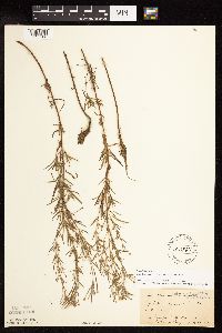 Epilobium leptophyllum Rafinesque 160387[1137566]Sandberg, John 6631891-07-28 United States, Minnesota, Chisago, Centre City;;034N;20W;, 45.4260802 -92.8361896 |
MIN:Plants | 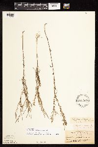 Epilobium leptophyllum Rafinesque 160389[1137584]Sandberg, John s.n.1885-08-00 United States, Minnesota, Goodhue, Red Wing;;N;;, 44.562468 -92.533801 |
MIN:Plants | 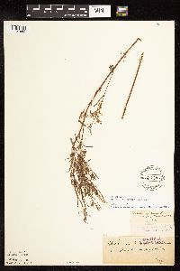 Epilobium leptophyllum Rafinesque 160390[1137652]Roberts, Thomas s.n.1879-08-30 United States, Minnesota, Lake, Near Stewart River;North Shore;053N;10W;29, 47.0487326 -91.6374302 |
MIN:Plants | 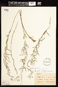 Epilobium leptophyllum Rafinesque 160391[1137586]Taylor, B. T15121892-08-00 United States, Minnesota, Chisago, North Branch;;035N;21W;, 45.5136887 -92.960162 |
MIN:Plants |  Epilobium leptophyllum Rafinesque 160392[1137585]Sheldon, Edmund S16641890-06-00 United States, Minnesota, Hennepin, Minneapolis;;N;;, 44.979965 -93.263836 |
MIN:Plants |  Epilobium leptophyllum Rafinesque 160393[1137591]Sandberg, John s.n.1890-07-00 United States, Minnesota, Hennepin, Hennepin Co.;;N;;, 45.02111 -93.482178 |
MIN:Plants |  Epilobium leptophyllum Rafinesque 160394[1137497]Ballard, C. B16311893-07-00 United States, Minnesota, Cass, Upper Gull Lake;;N;;, 46.526798 -94.34476 |
MIN:Plants |  Epilobium leptophyllum Rafinesque 160395[1137583]Sandberg, John s.n.1889-08-00 United States, Minnesota, Hennepin, Hennepin Co.;;N;;, 45.02111 -93.482178 |
MIN:Plants |  Epilobium leptophyllum Rafinesque 160396[1137494]MacMillan, C.; et al. M&S14031894-07-00 United States, Minnesota, Lake of the Woods, Sandy Beach [other collections by M&S indicate this is in Northwest Angle];Northwest Angle;;;, 49.16861 -95.07694 |
MIN:Plants |  Epilobium leptophyllum Rafinesque 160397[1137501]Leiberg, John s.n. United States, Minnesota, Blue Earth, [no further data];;N;;, 44.069593 -94.067505 |
MIN:Plants |  Epilobium leptophyllum Rafinesque 160398[1137495]Sheldon, Edmund S37981892-08-00 United States, Minnesota, Otter Tail, Sand Lake, Otter Tail Co.;;137N;43W;36, 46.6374433 -96.0565584 |
MIN:Plants |  Epilobium leptophyllum Rafinesque 160400[1137502]Ballard, C. B8421891-08-00 United States, Minnesota, Carver, Patterson Lake, Carver Co.;;116N;25W;, 44.8475998 -93.8277531 |
MIN:Plants |  Epilobium leptophyllum Rafinesque 160401[1137498]Taylor, B. T15121892-08-00 United States, Minnesota, Chisago, Centre City, Chisago Co.;;N;;, 45.393852 -92.816602 |
MIN:Plants |  Epilobium leptophyllum Rafinesque 160402[1137508]Campbell, Jennie s.n.1895-07-00 United States, Minnesota, Stearns, Pleasant Lake, Stearns Co.;;123N;29W;, 45.4574203 -94.3224782 |
MIN:Plants |  Epilobium leptophyllum Rafinesque 160403[1137506]Aiton, G. s.n.1884-07-00 United States, Minnesota, Hennepin, Hen. Co.;;N;;, 45.02111 -93.482178 |
MIN:Plants |  Epilobium leptophyllum Rafinesque 160404[1137599]Ballard, C. B6201891-07-00 United States, Minnesota, Scott, Shakopee;;115N;22W;, 44.7608534 -93.4595327 |
MIN:Plants |  Epilobium leptophyllum Rafinesque 160405[1137496]Taylor, B. T9541891-07-00 United States, Minnesota, Pope, Glenwood;;N;;, 45.650239 -95.389758 |
MIN:Plants |  Epilobium leptophyllum Rafinesque 160406[1137486]Skinner, A. 2921900-08-00 United States, Minnesota, Polk, Crookston;;N;;, 47.774138 -96.608121 |
MIN:Plants |  Epilobium leptophyllum Rafinesque 160408[1137484]Sheldon, Edmund s.n.1892-07-00 United States, Minnesota, Mille Lacs, Milaca;;038N;27W;, 45.7786745 -93.7002111 |
MIN:Plants |  Epilobium leptophyllum Rafinesque 160409[1137640]Frost, W. F3841892-08-00 United States, Minnesota, Kandiyohi, Spicer, Kandiyohi Co.;;N;;, 45.23302 -94.940009 |
MIN:Plants |  Epilobium leptophyllum Rafinesque 160411[1137589]Burglehaus, F. s.n.1891-07-00 United States, Minnesota, Hennepin, Hennepin Co.;;N;;, 45.02111 -93.482178 |
MIN:Plants |  Epilobium leptophyllum Rafinesque 160413[1137587]Bergman, H. 29771914-08-04 United States, Minnesota, Hubbard, Quadrat 6c, Benedict;;143N;32W;35, 47.1572871 -94.6956984 |
MIN:Plants |  Epilobium leptophyllum Rafinesque 160415[1137588]Herrick, C. s.n.1877-07-24 United States, Minnesota, Hennepin, Minneapolis;;N;;, 44.979965 -93.263836 |
MIN:Plants |  Epilobium leptophyllum Rafinesque 160497[1137626]Aiton, G. s.n.1892-07-00 United States, Minnesota, Hennepin, Vicinity of Minneapolis;;N;;, 45.02111 -93.482178 |
MIN:Plants |  Epilobium leptophyllum Rafinesque 160604[1137574]Leiberg, John s.n.1883-00-00 United States, Minnesota, Blue Earth, B.E. Co.;;N;;, 44.056764 -94.075745 |
MIN:Plants |  Epilobium leptophyllum Rafinesque 227326[1137575]Rosendahl, C. 54241927-08-26 United States, Minnesota, Anoka, Near Bunker Lake. Anoka Co.;Bunker Hills County Park;032N;24W;36, 45.2188189 -93.2757356 |
MIN:Plants |  Epilobium leptophyllum Rafinesque 256083[1137598]Frost, W. s.n.1892-08-00 United States, Minnesota, Kandiyohi, Spicer, Kandiyohi Co.;;N;;, 45.23302 -94.940009 |
MIN:Plants |  Epilobium leptophyllum Rafinesque 261990[1137633]Roberts, Thomas s.n.1925-07-31 United States, Minnesota, Saint Louis, 6 mi S of Ely;;N;;, 47.816394 -91.867087 |
MIN:Plants |  Epilobium leptophyllum Rafinesque 261993[1137637]Roberts, Thomas s.n.1925-08-05 United States, Minnesota, Saint Louis, Burntside L, Ely;Superior National Forest;N;;, 47.929943 -91.974694 |
MIN:Plants |  Epilobium leptophyllum Rafinesque 263897[1137646]Holzinger, John s.n.1897-07-00 United States, Minnesota, Winona, in Winona Co.;;N;;, 44.049963 -91.639315 |
MIN:Plants |  Epilobium leptophyllum Rafinesque 276185[1137573]Grant, Martin 29071929-08-17 United States, Minnesota, Hubbard, Itasca Park; Hubbard Co. SE of Mary Lake, NW-NE 30 T143 R35;Itasca State Park;143N;35W;30, 47.174244 -95.1607024 |
MIN:Plants |  Epilobium leptophyllum Rafinesque 276187[1137567]Grant, Martin 29071929-07-24 United States, Minnesota, Clearwater, Itasca Park; Clearwater Co, Floating Bog Bay, NE-NE 11 T143 R36;Itasca State Park;143N;36W;11, 47.2175215 -95.2014955 |
MIN:Plants |  Epilobium leptophyllum Rafinesque 277997[1137597]Roberts, Thomas s.n.1877-07-00 United States, Minnesota, Hennepin, Minneapolis;;N;;, 44.979965 -93.263836 |
MIN:Plants |  Epilobium leptophyllum Rafinesque 298356[1137572]Lakela, Olga 5891933-08-09 United States, Minnesota, Clearwater, Across Lake Itasca from School of Forestry, Itasca Park;Itasca State Park;143N;36W;, 47.2196 -95.2063 |
MIN:Plants |  Epilobium leptophyllum Rafinesque 336416[1137489]Lakela, Olga 16681936-08-08 United States, Minnesota, Saint Louis, Oatka Beach Addition, about 10 mi from the bay shore; Duluth;;N;;, 46.7833 -92.1 |
MIN:Plants |  Epilobium leptophyllum Rafinesque 353280[1137576]Moyle, J. 8681933-07-18 United States, Minnesota, Becker, Itasca Park; Becker Co, near De Soto Lake, SE-NW 3 T142 R36;Itasca State Park;142N;36W;3, 47.145259 -95.2227848 |
MIN:Plants |  Epilobium leptophyllum Rafinesque 353918[1137571]Moyle, J. 9741933-07-27 United States, Minnesota, Clearwater, Itasca Park; Clearwater Co. La Salle Trail, SE-SW-1 T143 R36;Itasca State Park;143N;36W;1, 47.31829 -95.1799547 |
MIN:Plants |  Epilobium leptophyllum Rafinesque 354874[1137578]Moyle, J. 7991933-07-14 United States, Minnesota, Clearwater, Itasca Park; Clearwater Co. NE-SE-2 T143 R36;Itasca State Park;143N;36W;2, 47.2319733 -95.201528 |
MIN:Plants |  Epilobium leptophyllum Rafinesque 355724[1137482]Rosendahl, C.; Dahlberg, R. s.n.1918-08-00 United States, Minnesota, Itasca, Grand Rapids, Itasca Co.;;N;;, 47.237166 -93.530214 |
MIN:Plants |  Epilobium leptophyllum Rafinesque 356452[1137485]Rosendahl, C.; Dahlberg, R. s.n.1918-08-00 United States, Minnesota, Pennington, Goodridge, Pennington Co.;;154N;40W;, 48.1510858 -95.7876468 |
MIN:Plants | 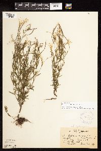 Epilobium leptophyllum Rafinesque 364577[1137490]Rosendahl, C.; Butters, F. 68891937-08-27 United States, Minnesota, Lake, Some 10 mi SE of Ely;Superior National Forest;N;;, 47.820806 -91.64204 |
MIN:Plants | 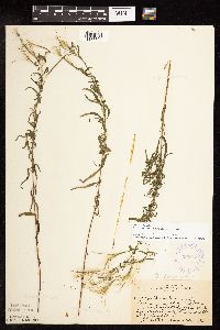 Epilobium leptophyllum Rafinesque 365069[1137504]Rosendahl, C.; Butters, F. 68501937-08-26 United States, Minnesota, Itasca, along Hwy. No.1, halfway between Effie and Toga, Itasca Co.;George Washington State Forest;N;;, 47.80673 -93.381213 |
MIN:Plants | 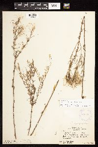 Epilobium leptophyllum Rafinesque 365071[1137635]Rosendahl, C.; Butters, F. 6861A1937-08-25 United States, Minnesota, Cass, Between Remer and Cohasset;Chippewa National Forest;N;;, 47.164484 -93.775993 |
MIN:Plants | 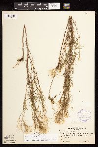 Epilobium leptophyllum Rafinesque 366552[1137590]Rosendahl, C. s.n.1939-08-00 United States, Minnesota, Clearwater, Across Itasca Lake from Forestry Schoolk, Clearwater Co.;Itasca State Park;143N;36W;, 47.197458 -95.201964 |
MIN:Plants |  Epilobium leptophyllum Rafinesque 375378[1137577]Lakela, Olga 50611942-07-23 United States, Minnesota, Carlton, Along railroad tracks, Holyoke, Carlton Co.;;046N;16W;, 46.4607854 -92.3628933 |
MIN:Plants |  Epilobium leptophyllum Rafinesque 385509[1137493]Moyle, J. 39401945-08-29 United States, Minnesota, Winona, Winona Co.; along Morey Creek;;N;;, 43.896822 -91.673128 |
MIN:Plants |  Epilobium leptophyllum Rafinesque 398562[1137581]Butters, F.; Abbe, E. 10571944-08-15 United States, Minnesota, Cook, Cook Co.; about 2 mi E of the Lake-Cook line, T58N R5W;Finland State Forest / North Shore;058N;05W;, 47.5173977 -90.9783519 |
MIN:Plants |  Epilobium leptophyllum Rafinesque 398563[1137580]Butters, F.; Abbe, E. 7541944-07-27 United States, Minnesota, Cook, Cook Co.; about 12 mi W of Grand Marais, T60N R2W;North Shore / Superior National Forest;060N;02W;, 47.696951 -90.5918251 |
MIN:Plants |  Epilobium leptophyllum Rafinesque 398564[1137579]Butters, F.; Abbe, E. 9651944-08-09 United States, Minnesota, Cook, Cook County...on old road to foot of Mt. Josephine, Grand Portage, T63N R8E [should be R6];Grand Portage Indian Reservation / North Shore;063N;06E;03, 47.9708959 -89.6619997 |
MIN:Plants |  Epilobium leptophyllum Rafinesque 398578[1137500]Nielsen, E. 16911932-09-13 United States, Minnesota, Cook, Clearwater Lake, Cook Co.;Boundary Waters Canoe Area Wilderness / Superior National Forest;065N;01E;, 48.0810547 -90.3151891 |
MIN:Plants |  Epilobium leptophyllum Rafinesque 409170[1137487]Moore, John; Moore, Marjorie 113621939-08-02 United States, Minnesota, Roseau, Roseau Co.; 1.3 mi N of Longworth, elevation 1072 feet.;;164N;37W;, 48.986092 -95.4201477 |
MIN:Plants |  Epilobium leptophyllum Rafinesque 412541[1137483]Moore, John; Moore, Marjorie 112601939-07-28 United States, Minnesota, Lake of the Woods, Lake of the Woods Co.; 2 1/4 mi S of Angle Inlet;Northwest Angle;;;, 49.316745 -95.062738 |
MIN:Plants |  Epilobium leptophyllum Rafinesque 418893[1137641]Ahlgren, Clifford 3591949-08-31 United States, Minnesota, Lake, Quetico-Superior Wilderness Research Center...Lake Co. Sec.9, T64N, R10W;Boundary Waters Canoe Area Wilderness / Superior National Forest;064N;10W;09, 48.0316509 -91.6188616 |
MIN:Plants |  Epilobium leptophyllum Rafinesque 424009[1137627]Emanuel, J. 831946-07-28 United States, Minnesota, Itasca, County: Itasca. Locality: Nashwauk Township;;057N;22W;00, 47.40917 -93.195 |
MIN:Plants |  Epilobium leptophyllum Rafinesque 424047[1137505]Emanuel, J. 1341946-09-03 United States, Minnesota, Itasca, County: Itasca. Locality: Nashwauk Township (Stevenson Road) [this connects Nashwauk & Hibbing];;057N;22W;00, 47.4143822 -93.1322285 |
MIN:Plants |  Epilobium leptophyllum Rafinesque 425920[1137643]Moyle, J. s.n.1951-08-15 United States, Minnesota, Roseau, Roseau Co.; Roseau Bog;;N;;, 48.846093 -95.762766 |
MIN:Plants |  Epilobium leptophyllum Rafinesque 426898[1137463]Smith, Welby 123001986-07-30 United States, Minnesota, Goodhue, Perched Valley Wildlife Management Area. Goodhue County...Perched Valley State Wildlife Management Area, about 4 mi W of Frontenac; base of a NE-facing bluff; NW1/4 SW1/4 sec.8, T112N R13W. 112N 13W 8, 44.5172222 -92.4063889 |
MIN:Plants |  Epilobium leptophyllum Rafinesque 428251[1137458]Mensing, D. 95-3771995-08-30 United States, Minnesota, Isanti, Isanti Co, T36N R25W NE1/4 of the SW1/4 of S35; floodplain of Green Lake Brook; in DNR WMA.;Spectacle Lake Wildlife Management Area;036N;25W;35, 45.5653251 -93.419892 |
MIN:Plants |  Epilobium leptophyllum Rafinesque 439548[1137451]Harris, Fred 931601993-08-31 United States, Minnesota, Polk, Polk Co. McIntosh Channel; SE1/4 SW1/4 Sec 27 T148N R41W CBS site 84;;148N;41W;27, 47.6078807 -95.8648419 |
Google Map
Google Maps is a web mapping service provided by Google that features a map that users can pan (by dragging the mouse) and zoom (by using the mouse wheel). Collection points are displayed as colored markers that when clicked on, displays the full information for that collection. When multiple species are queried (separated by semi-colons), different colored markers denote each individual species.