University of Minnesota
http://www.umn.edu/
612-625-5000
http://www.umn.edu/
612-625-5000
Minnesota Biodiversity Atlas
Bell Museum
Dataset: MIN-Plants
Taxa: Paulowniaceae
Search Criteria: excluding cultivated/captive occurrences
1
Page 1, records 1-3 of 3
Bell Museum plants | |
 MIN:Plants | 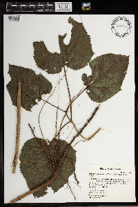 Paulownia tomentosa (Thunb.) Sieb. & Zucc. ex Steud. 966016[1356776]Suzanne Wold-Burkness 2019-09-01 United States, Minnesota, Houston, 5.25 miles southwest of Spring Grove, 0.6 miles south west of intersection of Belleville Drive and Berry Drive; T101N R37W sec31 NW NE, 43.5124211 -91.7172384, 379m |
MIN:Plants | 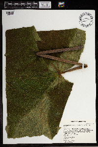 Paulownia tomentosa (Thunb.) Sieb. & Zucc. ex Steud. 966017[1356777]Suzanne Wold-Burkness 2019-09-01 United States, Minnesota, Houston, 5.25 miles southwest of Spring Grove, 0.6 miles south west of intersection of Belleville Drive and Berry Drive; T101N R37W sec31 NW NE, 43.5124211 -91.7172384, 379m |
MIN:Plants | 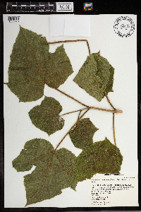 Paulownia tomentosa (Thunb.) Sieb. & Zucc. ex Steud. 966018[1356778]Suzanne Wold-Burkness 2019-09-01 United States, Minnesota, Houston, 5.25 miles southwest of Spring Grove, 0.6 miles south west of intersection of Belleville Drive and Berry Drive; T101N R37W sec31 NW NE, 43.5124211 -91.7172384, 379m |
1
Page 1, records 1-3 of 3
Google Map
Google Maps is a web mapping service provided by Google that features a map that users can pan (by dragging the mouse) and zoom (by using the mouse wheel). Collection points are displayed as colored markers that when clicked on, displays the full information for that collection. When multiple species are queried (separated by semi-colons), different colored markers denote each individual species.