University of Minnesota
http://www.umn.edu/
612-625-5000
http://www.umn.edu/
612-625-5000
Minnesota Biodiversity Atlas
Bell Museum
Dataset: MIN-Plants
Taxa: Scrophulariaceae
Search Criteria: excluding cultivated/captive occurrences
Bell Museum plants | |
 MIN:Plants |  762256[1302573]Degener, Otto 363351982-06-11 Portugal, Azores, Turnas, Sao Miguel |
MIN:Plants |  189967[1302574]Howard, C. W. 91909-11-01 Mozambique |
MIN:Plants |  190110[1302600]Cook, Alice Carter 10451897-10-00 Spain, Tenerife: Agna Garcia |
MIN:Plants |  Buddleja Houst. ex L. 171870[1302576]Wood, J Medley s.n.1899-08-06 South Africa, hills near Verulam, 300m |
MIN:Plants | 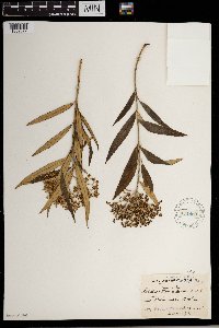 Buddleja Houst. ex L. 171869[1302577]Wood, J. Medley 46471892-09-29 South Africa, near Durban, 150m |
MIN:Plants | 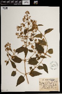 Buddleja Houst. ex L. 171836[1302578]Wood, J Medley 48691893-06-30 South Africa, from W. York, 3 - 4000m |
MIN:Plants | 190069[]Rosendahl, C. 38771919-08-09 United States, Minnesota, Fillmore, Root River Valley, Sec. 11, Holt Twp.;Dorer Memorial Hardwood State Forest;103N;09W;11, 43.738919 -91.879708 |
MIN:Plants | 274946[]Rosendahl, C. 57531928-09-19 United States, Minnesota, Dakota, At Pine Bend.;;115N;18W;18, 44.7678 -93.024207 |
MIN:Plants | 362302[]Rosendahl, C. 67851936-09-13 United States, Minnesota, Goodhue, Bottomlands of the Cannon River N of Tower Hill Farm, Hwy. 61.;;N;;, 44.585648 -92.557156 |
MIN:Plants | 383638[]Moore, John 160241943-08-25 United States, Minnesota, Winona, Winona Co.; Below Gwinn's Bluff;Great River Bluffs State Park;106N;05W;, 43.942065 -91.4667 |
MIN:Plants | 426897[]Smith, Welby 122771986-07-30 United States, Minnesota, Goodhue, Goodhue Co. About 5 mi W of Cannon Falls; S bank of the Cannon River. SW1/4 SE1/4 sec.7, T112n R18W;;112N;18W;7, 44.261981 -93.030794 |
MIN:Plants | 439468[]Smith, Welby 162141989-08-25 United States, Minnesota, Freeborn, Myre Big Island State Park. Freeborn County...Helmer Myre State Park, about 2 mi southeast of Albert Lea. On 'Big Island' in Albert Lea Lake; SW1/4 NW1/4 sec.19, T102N R20W. 102N 20W 19, 43.625 -93.2875 |
MIN:Plants | 514684[]Husveth, J. 95-31431995-08-30 United States, Minnesota, Wabasha, Wabasha Co, T110N R12W SW1/4 of the NE1/4 of S36; Zumbro River;Dorer Memorial Hardwood State Forest;110N;12W;36, 44.249964 -91.954363 |
MIN:Plants | 558430[]Moore, John; Hsi, Yu-tseng [Eugene] 234011957-08-07 United States, Minnesota, Blue Earth, Along the river at Mankato Springs, Sec. 29, SW1/4 Le Ray Twp.;;N;;, 44.130505 -93.978801 |
MIN:Plants | 585642[]Moore, John 261911962-10-02 United States, Minnesota, Houston, 1 mi N of La Crescent;;104N;04W;, 43.842506 -91.304027 |
MIN:Plants | 592028[]Moore, John 267691965-08-10 United States, Minnesota, Blue Earth, 3 mi. W of Mankato;;N;;, 44.16357 -94.03978 |
MIN:Plants | 708297[]Ownbey, Gerald 63521979-08-10 United States, Minnesota, Winona, Winona Co. Along Bear Creek, 1 mi. W of jct. of Bear Creek rte. to Altura (unnumbered) with Rte. 27, also to Altura. Ad Winona Co. Along Bear Creek, 1 mi. W of jct. of Bear Creek rte. to Altura (unnumbered) with Rte. 27, also to Altura. Adjacent to Bear Creek.. N , 44.073786 -91.869776 |
MIN:Plants | 782732[]Tenney, M. 3881982-07-07 United States, Minnesota, Fillmore, Forestville State Park. Fillmore Co. T102N, R12W, Sec. 12, SW1/4 NE1/4 SE1/4;Forestville State Park;102N;12W;12, 43.652157 -92.219232 |
MIN:Plants | 787619[]Smith, Welby 106721985-07-11 United States, Minnesota, Goodhue, On the banks of the Cannon River, ca. 3.5 mi. E of Welch. SW1/4 SW1/4 Sec. 25, T113N, R16W.;;113N;16W;25, 44.56323 -92.684577 |
MIN:Plants | 833436[]Juhnke, C. 2191991-07-27 United States, Minnesota, Fillmore, Forestville State Park. Fillmore Co. T102N R12W Sec.13 SE NW NE; between parking lot, trail, and bridge over Root River;Forestville State Park;102N;12W;13, 43.637724 -92.219269 |
MIN:Plants | 834178[]Smith, Welby 197791991-07-25 United States, Minnesota, Olmsted, Whitewater Wildlife Management Area. Olmsted Co. About 3.5 mi W-NW of Elba, in the Whitewater State Wildlife Management Area; Olmsted Co. About 3.5 mi W-NW of Elba, in the Whitewater State Wildlife Management Area; T107N R11W SE1/4 of SW1/4 of Sec 1. 107N 11W 1, 44.0952759 -92.0891647 |
MIN:Plants | 839141[]Smith, Welby 176381990-08-02 United States, Minnesota, Dodge, Dodge Co. About 3 mi NW of Byron. On a S-facing slope overlooking the South Branch Middle Fork Zumbro River; Dodge Co. About 3 mi NW of Byron. On a S-facing slope overlooking the South Branch Middle Fork Zumbro River; T107N R16W NE1/4 of SW1/4 of Sec 13. 107N 16W 13, 44.0708351 -92.6858368 |
MIN:Plants | 839263[]Smith, Welby 184721990-09-19 United States, Minnesota, Fillmore, Lost Lake Wildlife Management Area. Fillmore Co. Along the Root River Trail, in the Root River Valley. About 1.25 mi W of Lanesboro; Fillmore Co. Along the Root River Trail, in the Root River Valley. About 1.25 mi W of Lanesboro; T103N R10W NW1/4 of NW1/4 of Sec 23.. 103N 10W 23, 43.7138901 -92.0036087 |
MIN:Plants | 841194[]Smith, Welby 137471987-08-06 United States, Minnesota, Washington, Washington County...Island in Conoly Lake on the Mississippi River Bottoms, about 2 mi W of Point Douglas SE1/4 SW1/4 sec.8, T26N R20W. 026N 20W 8, 44.7508333 -92.8344444 |
MIN:Plants | 913747[]Smith, Welby 228331993-07-14 United States, Minnesota, Sibley, Vale Wildlife Management Area. Sibley County...Vale State Wildlife Management Area, ca 2.5 miles N-NW of Henderson; in the valley of High Island Creek, ca 2.5 miles SW of its confluence with the Minn R...T 113N R 26W NE1/4 of SW1/4 of Sec 27. 113N 26W 27, 44.5625 -93.9427778 |
MIN:Plants | 923345[]Smith, Welby 216211992-08-26 United States, Minnesota, Nicollet, About 7 miles north of Mankato; bank of Seven Mile Creek. NW1/4 of NE1/4 of section.;Seven Mile Creek County Park;109N;27W;11, 44.2680556 -94.0344444 |
MIN:Plants | 920544[]Smith, Welby 239141993-09-15 United States, Minnesota, Faribault, On the south side of Interstate 90, about one mile northwest of Blue Earth. SE1/4 of SW1/4 of section;;102N;27W;06, 43.6597222 -94.1186111 |
MIN:Plants | 922641[]Smith, Welby 234011993-08-04 United States, Minnesota, Wabasha, Carley State Park. Carley State Park, about 3 miles south of Plainview...floodplain of the North Fork Whitewater River...T 108N R 11W NW1/4 of NE1/4 of Sec 32. 108N 11W 32, 44.1194444 -92.175 |
MIN:Plants | 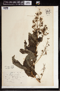 961218[1334692] United States, Illinois |
MIN:Plants | 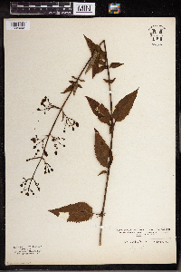 961217[1334693] United States, Indiana |
MIN:Plants |  967351[1359906]Welby R Smith 354202015-09-08 United States, Minnesota, Goodhue, Sandy beach on the main channel of the Mississippi River (at river mile 803.0), about 16 km (10 miles) southeast of the approximate center of Hastings. NW of NE of section, 44.671 -92.6771167 |
MIN:Plants | 914247[]Bolduan, Brad United States, Minnesota, Cottonwood, Detailed locality information protected. This is typically done to protect rare or threatened species localities. |
MIN:Plants | 272191[]Menzel, Max United States, Minnesota, Pipestone, Detailed locality information protected. This is typically done to protect rare or threatened species localities. |
MIN:Plants | 444761[]Moore, John; et al. United States, Minnesota, Rock, Detailed locality information protected. This is typically done to protect rare or threatened species localities. |
MIN:Plants | 444941[]Moore, John; et al. United States, Minnesota, Rock, Detailed locality information protected. This is typically done to protect rare or threatened species localities. |
MIN:Plants | 503028[]Moore, John United States, Minnesota, Big Stone, Detailed locality information protected. This is typically done to protect rare or threatened species localities. |
MIN:Plants | 566247[]Moore, John; et al. United States, Minnesota, Kittson, Detailed locality information protected. This is typically done to protect rare or threatened species localities. |
MIN:Plants | 574515[]Moore, John United States, Minnesota, Kittson, Detailed locality information protected. This is typically done to protect rare or threatened species localities. |
MIN:Plants | 585579[]Moore, John United States, Minnesota, Pipestone, Detailed locality information protected. This is typically done to protect rare or threatened species localities. |
MIN:Plants | 711434[]Smith, Welby United States, Minnesota, Pipestone, Detailed locality information protected. This is typically done to protect rare or threatened species localities. |
MIN:Plants | 711446[]Smith, Welby United States, Minnesota, Rock, Detailed locality information protected. This is typically done to protect rare or threatened species localities. |
MIN:Plants | 778278[]Converse, C. United States, Minnesota, Lac Qui Parle, Detailed locality information protected. This is typically done to protect rare or threatened species localities. |
MIN:Plants | 812594[]Ostlie, Wayne United States, Minnesota, Lac Qui Parle, Detailed locality information protected. This is typically done to protect rare or threatened species localities. |
MIN:Plants | 830118[]Converse, C. United States, Minnesota, Big Stone, Detailed locality information protected. This is typically done to protect rare or threatened species localities. |
MIN:Plants | 830122[]Converse, C. United States, Minnesota, Big Stone, Detailed locality information protected. This is typically done to protect rare or threatened species localities. |
MIN:Plants | 966903[1359594]MacFarlane, Malcolm United States, Minnesota, Cottonwood, Detailed locality information protected. This is typically done to protect rare or threatened species localities. |
MIN:Plants | Verbascum virgatum Stokes 491560[]Williams, M. s.n.1983-09-00 United States, Nevada, Washoe Co. -- cultivated, 1341m |
MIN:Plants | Verbascum chaixii Villars 689522[]Schimpf, D. DJS3252002-07-18 United States, Minnesota, Saint Louis, St. Louis County, Duluth. T50N R14W NE1/4 Sec 15 ... 1125 Brainerd Ave;;050N;14W;15, 46.8166656 -92.0833359 |
MIN:Plants | 916893[]Smith, Welby 251731994-08-18 United States, Minnesota, Beltrami, Lake Bemidji State Park. Beltrami County ... On the northeast side of Lake Bemidji, in Lake Bemidji State Park ... T147N R33W SW1/4 of NE1/4 of Sec 23. 147N 33W 23, 47.5347222 -94.8311111 |
MIN:Plants | 499266[]Juhnke, C. 402 CMJ FRO1999-07-01 United States, Minnesota, Goodhue, Frontenac State Park Goodhue County ...On Rattelsnake [sic] Bluff near bridge on Hill Ave. ... T112N R13W SW SW NE 5;Frontenac State Park;112N;13W;05, 44.534983 -92.400158 |
MIN:Plants | 520909[]Gerdes, Lynden 30151998-07-22 United States, Minnesota, Cook, Superior National Forest. T65N R03W S32SWNE. Cook County ... Superior National Forest. Boat landing/public access area at the far west end of Loon Lake.. 065N 03W 32, 48.070286 -90.740698 |
MIN:Plants | 912486[]Smith, Welby 230421993-07-21 United States, Minnesota, Meeker, Meeker County... On the south side of T.H. 12; about 2 miles southeast of Darwin... T119N R30W NW1/4 of SE1/4 of Sec 25;;119N;30W;25, 45.0872222 -94.3916667 |
MIN:Plants | 430235[]DeMink, L. 3982000-09-18 United States, Minnesota, Morrison, Crane Meadows National Wildlife Refuge; NWNE 30-T40N-R31W;Crane Meadows National Wildlife Refuge;040N;31W;30, 45.933896 -94.251565 |
MIN:Plants | 913053[]Smith, Welby 229871993-07-20 United States, Minnesota, Sibley, Sibley County ... At the southeast corner of Silver Lake, about 5 miles east of Arlington ... At the public access... T113N R26W NW1/4 of NW1/4 of Sec 9. 113N 26W 9, 44.6130556 -93.9686111 |
MIN:Plants | 506948[]Bright, R. 72-41972-00-00 United States, Idaho, Franklin, [no further data] |
MIN:Plants | 794681[]Schaaf, J. 3031982-10-03 United States, California, Alpine, Alpine Co. ... Toiyabe Nat'l Forest, Grover Hot Springs, 2438m |
MIN:Plants | 906093[]Nelson, Michael; et al. M202008-10-15 United States, Minnesota, Ramsey, Ramsey Co, Hidden Falls Park, approx 0.5 Km south of Ford parkway along East Rivr Road, by a park trail along the bluff;Hidden Falls - Crosby Farm Regional Park;028N;23W;17, 44.912243 -93.197369 |
MIN:Plants | 263572[]Holzinger, John s.n.1901-06-00 United States, Minnesota, Winona, Winona Co.;;N;;, 43.98685 -91.779129 |
MIN:Plants | 265424[]Goldsmith, G. G.581912-00-00 United States, Minnesota, Dakota, Northfield;;N;;, 44.458298 -93.161604 |
MIN:Plants | 271411[]Aiton, G. s.n.1889-08-00 United States, Minnesota, Hennepin, [no further data];;;;, 45 -93.47 |
MIN:Plants | 271414[]Manning, Sara s.n.1884-07-23 United States, Minnesota, Wabasha, Lake City;;N;;, 44.449412 -92.266844 |
MIN:Plants | 271415[]Campbell, Jennie C.1761896-07-00 United States, Minnesota, Stearns, Rockville;;123N;29W;, 45.471909 -94.340827 |
MIN:Plants | 271416[]Sandberg, John s.n.1881-07-00 United States, Minnesota, Goodhue, Cannon Falls;;N;;, 44.506911 -92.905484 |
MIN:Plants | 271417[]Sheldon, Edmund S221891-06-00 United States, Minnesota, Le Sueur, Elysian;;109N;24W;, 44.198577 -93.673838 |
MIN:Plants | 271418[]Kassube, J. s.n.1877-00-00 United States, Minnesota, Hennepin, Minneapolis;;N;;, 44.979965 -93.263836 |
MIN:Plants | 271419[]Taylor, B. T2971891-06-00 United States, Minnesota, Waseca, Janesville;;N;;, 44.116078 -93.708004 |
MIN:Plants | 271420[]Frost, W. F2991892-07-00 United States, Minnesota, Kandiyohi, Willmar;;N;;, 45.121908 -95.043342 |
MIN:Plants | 271421[]Ballard, C. B25n1891-06-00 United States, Minnesota, Carver, Chaska;;N;;, 44.789407 -93.602179 |
MIN:Plants | 271422[]Ballard, C. B5591891-07-00 United States, Minnesota, Scott, Prior Lake;;N;;, 44.720982 -93.425645 |
MIN:Plants | 271425[]Sandberg, John s.n.1890-07-00 United States, Minnesota, Hennepin, [no further data];;;;, 45 -93.47 |
MIN:Plants | 271426[]Herrick, C. s.n.1876-07-00 United States, Minnesota, Hennepin, Minneapolis;;N;;, 44.979965 -93.263836 |
MIN:Plants | 346735[]Lakela, Olga 21121937-08-01 United States, Minnesota, Saint Louis, at the jnc of Snively Boulevard and Jean Du Luth Rd, Duluth.;;N;;, 46.7833 -92.1 |
MIN:Plants | 353682[]Moyle, J. 13101934-07-12 United States, Minnesota, Hubbard, Itasca Park. Near entrance of park.;Itasca State Park;143N;35W;, 47.19592 -95.107697 |
MIN:Plants | 372995[]Moore, John; et al. 145981941-07-05 United States, Minnesota, Wright, edge of Pleasant Lake; Annandale. Wright Co.;;;;, 45.27492 -94.124696 |
MIN:Plants | 393025[]Lakela, Olga 73171947-09-02 United States, Minnesota, Saint Louis, Roadside near Brookston on Hwy. 2.;;N;;, 46.86772 -92.603804 |
MIN:Plants | 393531[]Stevens, O. s.n.1947-08-18 United States, Minnesota, Clay, [no further data];Buffalo River State Park;139N;46W;10, 46.863699 -96.472855 |
MIN:Plants | 416677[]Lakela, Olga 85001949-06-25 United States, Minnesota, Saint Louis, roadside, #21, Ely.;;N;;, 47.9 -91.8667 |
MIN:Plants | 420616[]Lakela, Olga 109561950-07-29 United States, Minnesota, Saint Louis, at Duluth Air Port, Duluth.;;N;;, 46.7833 -92.1 |
MIN:Plants | 421222[]Lakela, Olga 111291950-08-04 United States, Minnesota, Saint Louis, Trail along the Whiteface River dam, 6 mi. S of Markham.;;N;;, 47.196447 -92.2167 |
MIN:Plants | 429836[]Smith, Welby 196011991-07-17 United States, Minnesota, Itasca, Itasca Co.; Scenic State Park; about 3 miles southeast of Big Fork; T 60N R 26W NE1/4 of NE1/4 of Sec 1;Scenic State Park;060N;26W;1, 47.7213898 -93.5805588 |
MIN:Plants | 439854[]Myhre, K. 42211993-07-21 United States, Minnesota, Pine, Pine Co. Located 4 mi N of Head of the Rapids Landing on the St. Croix River; T40N R19W SE1/4 of SW1/4 of Sec 10;Saint Croix State Park;040N;19W;10, 45.967864 -92.701796 |
MIN:Plants | 443067[]Lakela, Olga 135491951-08-08 United States, Minnesota, Saint Louis, Old North Shore Rd. Lester Park, Duluth.;North Shore;050N;13W;05, 46.7833 -92.1 |
MIN:Plants | 445913[]Moore, John; Huff, N. 180091945-07-26 United States, Minnesota, Morrison, Along the shore of Twin Lakes, 5 mi. W of Little Falls;;N;;, 45.976307 -94.466673 |
MIN:Plants | 457313[]Myhre, K. 52101994-07-25 United States, Minnesota, Itasca, Itasca Co.; located 1/2 mile W of the town of Spring Lake; T 148N R 25W NW1/4 of NW1/4 of Sec 17;Chippewa National Forest / Leech Lake Indian Reservation;148N;25W;17, 47.640407 -93.875262 |
MIN:Plants | 458600[]Puchalski, L. 3971993-08-11 United States, Minnesota, Polk, Polk Co.; T148N R43W SW1/4 of SW1/4 of Sec 24;;148N;43W;24, 47.62176 -96.078286 |
MIN:Plants | 460316[]Smith, Welby 210451992-07-20 United States, Minnesota, Redwood, Cedar Rock Wildlife Management Area. Redwood Co.; In Cedar Rock State Wildlife Management Area, about 4 miles north-northwest of Redwood Falls; Redwood Co.; In Cedar Rock State Wildlife Management Area, about 4 miles north-northwest of Redwood Falls; T 113N R 36W NW1/4 of NW1/4 of Sec 11. 113N 36W 11, 44.6122208 -95.1563873 |
MIN:Plants | 460594[]Myhre, K. 3721991-07-10 United States, Minnesota, Aitkin, Aitkin County...Located 1.8 miles southeast of Elm Island Lake...T 46N R 26W SE1/4 of NE1/4 of Sec 26;;046N;26W;26, 46.440545 -93.582525 |
MIN:Plants | 464484[]Nation, R. 94-2351994-07-05 United States, Minnesota, Mower, Lake Louise State Park. Mower Co.; Tract 6. T101N R14W SW1/4 of NE1/4 of Sec. 29;Lake Louise State Park;101N;14W;29, 43.522073 -92.538882 |
MIN:Plants | 501620[]Stevens, O. s.n.1954-09-15 United States, Minnesota, Pipestone, Pipestone Nat. Monument;Pipestone National Monument;106N;46W;, 44.013519 -96.324755 |
MIN:Plants | 514904[]Smith, Welby 192851991-07-09 United States, Minnesota, Koochiching, Pine Island State Forest. Koochiching County ... about 5 miles southwest of Big Falls. Along Hickes Ridge Road, about 0.5 mile north of U.S. Hwy 71. Abandoned gravel pit ... T 154N R 25W NE1/4 of SW1/4 Sec. 30. 154N 25W 30, 48.127224 -93.8974991 |
MIN:Plants | 518737[]Darveaux, B. s.n.1991-06-24 United States, Minnesota, Washington, Forest Lake, Anoka Co. [Washington Co.] Left side of exit ramp 129 off of highway 35.;;032N;21W;7, 45.275646 -93.009582 |
MIN:Plants | 519922[]Smith, Welby 196721991-07-18 United States, Minnesota, Roseau, Roseau Co.; in Warroad, boat landing on Lake of the Woods (Muskeg Bay); T163N R36W SE1/4 of SW1/4 of SEc 28;;163N;36W;28, 48.9055557 -95.3016663 |
MIN:Plants | 526615[]Merrell, Ted s.n.1947-09-28 United States, Minnesota, Rice, Northfield;;N;;, 44.458298 -93.161604 |
MIN:Plants | 542494[]Moore, John 213811951-10-09 United States, Minnesota, Steele, Growing along the N shore of Rice Lake, Sec.11, Havana Twp.;Rice Lake State Park;107N;19W;, 44.089657 -93.068933 |
MIN:Plants | 542952[]Lakela, Olga; Davidson, Donald 216741957-07-26 United States, Minnesota, Lake, Cleared area on Tomahawk Trail close to Jct. No. 1;Superior National Forest;;;, 47.75 -91.5 |
MIN:Plants | 549862[]Moore, John 219601954-09-13 United States, Minnesota, Sherburne, 3 1/2 mi. S of Princeton;;N;;, 45.516159 -93.568582 |
MIN:Plants | 553707[]Moore, John 226881955-07-27 United States, Minnesota, Otter Tail, Along the S shore of Tamarac Lake, W of Dunvilla;;N;;, 46.664663 -96.077964 |
MIN:Plants | 558298[]Moore, John; Hsi, Yu-tseng [Eugene] 234231957-08-07 United States, Minnesota, Blue Earth, Along the Le Sueur River, Sec. 7, Decoria Twp.;;N;;, 44.086939 -93.998328 |
MIN:Plants | 558375[]Moore, John; Moore, Marjorie 235711957-09-19 United States, Minnesota, Isanti, N of the Cornea House, SW1/4 Sec. 22, Athens Twp, Cedar Creek Forest.;Cedar Creek National History Area;034N;23W;22, 45.417997 -93.197853 |
MIN:Plants | 560730[]Ownbey, Gerald 27891959-07-08 United States, Minnesota, Clearwater, SE1/4 Sec.27 T144N R36W. 0.2 mi W of Lake Itasca Post Office.;;144N;36W;27, 47.260545 -95.223135 |
Google Map
Google Maps is a web mapping service provided by Google that features a map that users can pan (by dragging the mouse) and zoom (by using the mouse wheel). Collection points are displayed as colored markers that when clicked on, displays the full information for that collection. When multiple species are queried (separated by semi-colons), different colored markers denote each individual species.