University of Minnesota
http://www.umn.edu/
612-625-5000
http://www.umn.edu/
612-625-5000
Minnesota Biodiversity Atlas
Bell Museum
Dataset: MIN-Lichens
Taxa: Acarosporaceae
Search Criteria: excluding cultivated/captive occurrences
Bell Museum lichens | |
 MIN:Lichens | Acarospora socialis H. Magn. 783131[]Wetmore, C. 552571986-06-28 United States, Arizona, Pima, Rincon Section, Loop Drive; Saguaro National Monument, 32.19277778 -110.7083333 |
MIN:Lichens | Acarospora socialis H. Magn. 783140[]Wetmore, C. 552471986-06-28 United States, Arizona, Pima, Rincon Section, Headquarters Picnic Area; Saguaro National Monument, 32.16694444 -110.7233333 |
MIN:Lichens | Acarospora socialis H. Magn. 783152[]Wetmore, C. 552351986-06-28 United States, Arizona, Pima, Rincon Section, Headquarters Picnic Area; Saguaro National Monument, 32.16694444 -110.7233333 |
MIN:Lichens | Acarospora socialis H. Magn. 783160[]Wetmore, C. 552241986-06-28 United States, Arizona, Pima, Rincon Section, Speedway Road, E End; Saguaro National Monument, 32.23361111 -110.7308333 |
MIN:Lichens | Acarospora socialis H. Magn. 783914[]Wetmore, C. 543801986-06-13 United States, Arizona, Pima, Rincon Mt. Section, Reef Rock; Saguaro National Monument, 32.21416667 -110.5325 |
MIN:Lichens | Acarospora socialis H. Magn. 842368[]Egan, R. 135701988-12-28 United States, Arizona, Maricopa, 5 km W of Canyon Lake, 31.51666667 -111.45 |
MIN:Lichens | Acarospora socialis H. Magn. 842562[]Wetmore, C. 740571994-01-08 United States, California, Santa Barbara, Santa Cruz Island, Fraser Point, Terrace; Channel Islands National Park, 34.0625 -119.9125 |
MIN:Lichens | Acarospora socialis H. Magn. 842567[]Wetmore, C. 740121994-01-07 United States, California, Santa Barbara, Santa Cruz Island, Ridge N of Ragged Mt.; Channel Islands National Park, 33.99166667 -119.8208333 |
MIN:Lichens | Acarospora socialis H. Magn. 842572[]Wetmore, C. 739081994-01-05 United States, California, Santa Barbara, Santa Rosa Island South Point; Channel Islands National Park, 33.9 -120.1208333 |
MIN:Lichens | Acarospora socialis H. Magn. 842578[]Wetmore, C. 737011994-01-02 United States, California, Santa Barbara, Santa Rosa Island, W of Radar Station Hill; Channel Islands National Park, 33.94583333 -120.125 |
MIN:Lichens | Acarospora socialis H. Magn. 842593[]Wetmore, C. 735351994-01-01 United States, California, Santa Barbara, Santa Rosa Island, S Slope of Black Mt.; Channel Islands National Park, 33.97916667 -120.075 |
MIN:Lichens | Acarospora socialis H. Magn. 842602[]Wetmore, C. 733441993-12-29 United States, California, Los Angeles, Santa Catalina Island; Near Parsons Landing, 33.475 -118.5458333 |
MIN:Lichens | Acarospora socialis H. Magn. 842603[]Wetmore, C. 733091993-12-28 United States, California, Los Angeles, Santa Catalina Island, Empire Landing (Rippers Cove), 33.42916667 -118.4333333 |
MIN:Lichens | Acarospora socialis H. Magn. 887434[]Wetmore, C. 797771998-01-09 Mexico, Baja California Sur, 15 km S of Rosarito, 28.52638889 -114.0416667 |
MIN:Lichens | Acarospora socialis H. Magn. 887461[]Wetmore, C. 794101998-01-03 Mexico, Baja California Sur, Guadalupe Mountains, Sierra La Palmita & Sierra San Pedro, 26.89833333 -112.4352778 |
MIN:Lichens | Acarospora socialis H. Magn. 887470[]Wetmore, C. 793001997-12-31 Mexico, Baja California Sur, Sierra San Francisco, Nw Slope, Sierra Agua Verde, 27.58777778 -113.0575 |
MIN:Lichens | Acarospora socialis H. Magn. 887476[]Wetmore, C. 792301997-12-30 Mexico, Baja California, 2 km Wnw of Laguna Chapala, 29.39416667 -114.3916667 |
MIN:Lichens | Acarospora socialis H. Magn. 887477[]Wetmore, C. 792001997-12-29 Mexico, Baja California, 20 km E of Arroyo El Rosario Bridge, 30.03888889 -115.5133333 |
MIN:Lichens | Acarospora socialis H. Magn. 887488[]Wetmore, C. 791221997-12-28 Mexico, Baja California, Coast 1 km S of Arroyo San Rafael, 30.95861111 -116.2619444 |
MIN:Lichens | Acarospora socialis H. Magn. 887501[]Wetmore, C. 757331995-12-31 Mexico, Baja California, Guadalupe Island, W End of Airstrip, 29.025 -118.2777778 |
MIN:Lichens | Acarospora socialis H. Magn. 887528[]Wetmore, C. 738001994-01-03 United States, California, Santa Barbara, Santa Rosa Island Old Ranch Canyon; Channel Islands National Park, 33.97083333 -119.9916667 |
MIN:Lichens | Acarospora socialis H. Magn. 887531[]Wetmore, C. 737781994-01-03 United States, California, Santa Barbara, Santa Rosa Island E of Sierra Pablo; Channel Islands National Park, 33.94166667 -120.0208333 |
MIN:Lichens | Acarospora socialis H. Magn. 887574[]Wetmore, C. 720671993-02-17 Mexico, Baja California Sur, 62 km Wnw of La Paz, 24.2 -110.9666667 |
MIN:Lichens | Acarospora socialis H. Magn. 887601[]Wetmore, C. 716221993-02-07 United States, Arizona, Santa Cruz, Sycamore Canyon, W of Nogales, 31.41666667 -110.1833333 |
MIN:Lichens | Acarospora socialis H. Magn. 887609[]Wetmore, C. 700901992-03-18 Mexico, Baja California Sur, San Javier Wash, 25.60833333 -111.75 |
MIN:Lichens | Acarospora socialis H. Magn. 887631[]Wetmore, C. 639531989-01-08 Mexico, Baja California Sur, Pass, Sierra De La Giganta, 25.6 -111.3333333 |
MIN:Lichens | Acarospora socialis H. Magn. 887675[]Wetmore, C. 633401988-12-29 United States, Arizona, Pinal, Boyce Thompson Arboretum, 33.26083333 -111.1538889 |
MIN:Lichens | Acarospora socialis H. Magn. 887680[]Wetmore, C. 633031988-12-28 United States, Arizona, Maricopa, W of Canyon Lake, 33.53138889 -111.4533333 |
MIN:Lichens | Acarospora socialis H. Magn. 887681[]Wetmore, C. 632961988-12-28 United States, Arizona, Maricopa, W of Canyon Lake, 33.53138889 -111.4533333 |
MIN:Lichens | Acarospora socialis H. Magn. 887685[]Wetmore, C. 632761988-12-27 United States, Arizona, Maricopa, Pima Canyon; Phoenix South Mountain Park, 33.36222222 -112.0058333 |
MIN:Lichens | Acarospora socialis H. Magn. 890356[]Egan, R. 135991988-12-29 United States, Arizona, Pinal, Boyce Thompson Arboretum & Picket Post Mt., 33.26666667 -111.1666667 |
MIN:Lichens | Acarospora socialis H. Magn. 890361[]Egan, R. 135711988-12-28 United States, Arizona, Maricopa, 5 km W of Canyon Lake, 31.51666667 -111.45 |
MIN:Lichens | Acarospora socialis H. Magn. 890362[]Egan, R. 135621988-12-27 United States, Arizona, Maricopa, Pima Canyon, Phoenix; South Mountain Park, 33.36666667 -111.9666667 |
MIN:Lichens | Acarospora socialis H. Magn. 890363[]Egan, R. 135591988-12-27 United States, Arizona, Maricopa, Pima Canyon, Phoenix; South Mountain Park, 33.36666667 -111.9666667 |
MIN:Lichens | Acarospora socialis H. Magn. 890364[]Egan, R. 135501988-12-27 United States, Arizona, Maricopa, Pima Canyon, Phoenix; South Mountain Park, 33.36666667 -111.9666667 |
MIN:Lichens | Acarospora socialis H. Magn. 890365[]Egan, R. 135461988-12-27 United States, Arizona, Maricopa, Pima Canyon, Phoenix; South Mountain Park, 33.36666667 -111.9666667 |
MIN:Lichens | Acarospora socialis H. Magn. 901581[]Wetmore, C. 954642007-04-17 United States, Minnesota, Cottonwood, 15 Mi N of Windom; Jeffers Petroglyphs Historic Site, 44.09222222 -95.05361111 |
MIN:Lichens | Acarospora socialis H. Magn. 928427[]Wetmore, C. 992302010-06-15 United States, New Mexico, Cibola, Lava Beds, 9 Mi S of Grants; El Malpais National Conservation Area, 35.02194444 -107.8175 |
MIN:Lichens | Acarospora socialis H. Magn. 932011[]Wetmore, C. 989152010-06-11 United States, New Mexico, San Miguel, Villanueva, Near, 35.27361111 -105.3822222 |
MIN:Lichens | 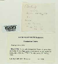 Acarospora socialis H. Magn. 956512[1288423]Wetmore, C. 66381960-06-30 United States, South Dakota, Pennington, Black Hills, Angostura Reservoir, N End above dam on E side of lake, 43.34 -103.4338889, 1006m |
MIN:Lichens |  Acarospora socialis H. Magn. 893059[1388478]Schoeninger United States, Arizona, Maricopa |
MIN:Lichens | 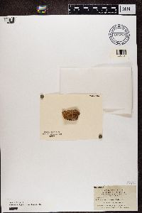 Acarospora squamulosa (Schrad.) Trevis. 865272[1362988]Hasse, H.E. United States, California |
MIN:Lichens | Acarospora stapfiana (Müll. Arg.) Hue 654817[]Wetmore, C. 166701967-06-14 United States, Nevada, Washoe, Pyramid Lake, 2.5 Mi S of |
MIN:Lichens | Acarospora stapfiana (Müll. Arg.) Hue 654824[]Wetmore, C. 166111967-06-13 United States, Utah, Tooele, Low, 5 Mi W of |
MIN:Lichens | Acarospora stapfiana (Müll. Arg.) Hue 742943[]Wetmore, C. 443261982-07-15 United States, North Dakota, McKenzie, Grassland Overlook, Ridge; Theodore Roosevelt National Park, 47.62638889 -103.3997222 |
MIN:Lichens | Acarospora stapfiana (Müll. Arg.) Hue 743070[]Wetmore, C. 441931982-07-14 United States, North Dakota, McKenzie, Stevens Plateau, Prairie; Theodore Roosevelt National Park, 47.60055556 -103.3047222 |
MIN:Lichens | Acarospora stapfiana (Müll. Arg.) Hue 780766[]Sanchini, P. 1091983-06-14 United States, Utah, San Juan, Grandview Point Picnic Area; Canyonlands National Park |
MIN:Lichens | Acarospora stapfiana (Müll. Arg.) Hue 780767[]Sanchini, P. 1081983-06-14 United States, Utah, San Juan, Grandview Point Picnic Area; Canyonlands National Park |
MIN:Lichens | Acarospora stapfiana (Müll. Arg.) Hue 853573[]Wetmore, C. 776611997-07-04 United States, Nebraska, Scotts Bluff, South Bluff, N Ridge; Scotts Bluff National Monument, 41.82222222 -103.7141667 |
MIN:Lichens | Acarospora stapfiana (Müll. Arg.) Hue 853600[]Wetmore, C. 776241997-07-03 United States, Nebraska, Scotts Bluff, Sw Ridge, N Bluff; Scotts Bluff National Monument, 41.83527778 -103.7038889 |
MIN:Lichens | Acarospora stapfiana (Müll. Arg.) Hue 853629[]Wetmore, C. 775711997-07-02 United States, Nebraska, Scotts Bluff, Nw Spur Ridge, N Bluff; Scotts Bluff National Monument, 41.83861111 -103.7027778 |
MIN:Lichens | Acarospora stapfiana (Müll. Arg.) Hue 853640[]Wetmore, C. 775571997-07-02 United States, Nebraska, Scotts Bluff, Nw Spur Ridge, N Bluff; Scotts Bluff National Monument, 41.83861111 -103.7027778 |
MIN:Lichens | Acarospora stapfiana (Müll. Arg.) Hue 853683[]Wetmore, C. 774731997-06-30 United States, Nebraska, Scotts Bluff, South Overlook; Scotts Bluff National Monument, 41.83527778 -103.7011111 |
MIN:Lichens | Acarospora stapfiana (Müll. Arg.) Hue 853700[]Wetmore, C. 774471997-06-30 United States, Nebraska, Scotts Bluff, North Overlook; Scotts Bluff National Monument, 41.83972222 -103.6980556 |
MIN:Lichens | Acarospora stapfiana (Müll. Arg.) Hue 853703[]Wetmore, C. 774431997-06-30 United States, Nebraska, Scotts Bluff, North Overlook; Scotts Bluff National Monument, 41.83972222 -103.6980556 |
MIN:Lichens | Acarospora stapfiana (Müll. Arg.) Hue 853738[]Wetmore, C. 779601997-07-09 United States, Nebraska, Sioux, 1 Mi E of Entrance; Agate Fossil Beds National Monument, 42.425 -103.7755556 |
MIN:Lichens | Acarospora stapfiana (Müll. Arg.) Hue 853752[]Wetmore, C. 779421997-07-09 United States, Nebraska, Sioux, 1 Mi W of Carnegie Hill; Agate Fossil Beds National Monument, 42.41666667 -103.7475 |
MIN:Lichens | Acarospora stapfiana (Müll. Arg.) Hue 853775[]Wetmore, C. 778971997-07-09 United States, Nebraska, Sioux, 1.5 Mi W of Hdqtrs On N of Road; Agate Fossil Beds National Monument, 42.42611111 -103.7675 |
MIN:Lichens | Acarospora stapfiana (Müll. Arg.) Hue 853780[]Wetmore, C. 778891997-07-09 United States, Nebraska, Sioux, 1 Mi W of Headquarters On N of Road; Agate Fossil Beds National Monument, 42.42527778 -103.7572222 |
MIN:Lichens | Acarospora stapfiana (Müll. Arg.) Hue 853790[]Wetmore, C. 778741997-07-08 United States, Nebraska, Sioux, Stenomylus Quarry; Agate Fossil Beds National Monument, 42.41055556 -103.6938889 |
MIN:Lichens | Acarospora stapfiana (Müll. Arg.) Hue 853807[]Wetmore, C. 778491997-07-08 United States, Nebraska, Sioux, University Hill; Agate Fossil Beds National Monument, 42.41694444 -103.7280556 |
MIN:Lichens | Acarospora stapfiana (Müll. Arg.) Hue 853819[]Wetmore, C. 778271997-07-08 United States, Nebraska, Sioux, Carnegie Hill; Agate Fossil Beds National Monument, 42.41638889 -103.7266667 |
MIN:Lichens | Acarospora stapfiana (Müll. Arg.) Hue 853845[]Wetmore, C. 777821997-07-07 United States, Nebraska, Sioux, W of Headquarters, S End of Ridge; Agate Fossil Beds National Monument, 42.42583333 -103.7463889 |
MIN:Lichens | Acarospora stapfiana (Müll. Arg.) Hue 853856[]Wetmore, C. 777621997-07-07 United States, Nebraska, Sioux, Nw of Headquarters Along Dirt Road; Agate Fossil Beds National Monument, 42.42722222 -103.7413889 |
MIN:Lichens | Acarospora stapfiana (Müll. Arg.) Hue 853860[]Wetmore, C. 777571997-07-06 United States, Nebraska, Sioux, 13 Mi N of Mitchell, 42.13777778 -103.8227778 |
MIN:Lichens | Acarospora stapfiana (Müll. Arg.) Hue 853904[]Wetmore, C. 776971997-07-04 United States, Nebraska, Scotts Bluff, South Bluff, W of Crown Rock; Scotts Bluff National Monument, 41.82027778 -103.7108333 |
MIN:Lichens | Acarospora stapfiana (Müll. Arg.) Hue 860435[]Wetmore, C. 800971998-06-23 United States, North Dakota, McKenzie, N Unit, E of Edge of Glacier Overlook; Theodore Roosevelt National Park, 47.61777778 -103.43 |
MIN:Lichens | Acarospora stapfiana (Müll. Arg.) Hue 860613[]Wetmore, C. 809591998-07-21 United States, Montana, Park, Grazing Exclosure W of Gardiner; Yellowstone National Park, 45.03583333 -110.7316667 |
MIN:Lichens | Acarospora stapfiana (Müll. Arg.) Hue 888892[]Egan, R. 165992004-08-05 United States, Utah, Emery, San Rafael Swell, 0.2 Mi N of Wedge Overlook, 39.09611111 -110.7594444 |
MIN:Lichens |  Acarospora stapfiana (Müll. Arg.) Hue 880827[1364599]John Republic of Türkiye, Kayseri |
MIN:Lichens | 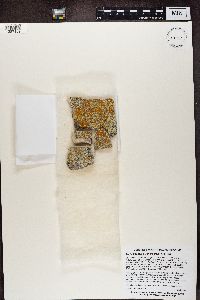 Acarospora stapfiana (Müll. Arg.) Hue 939197[1387109]Morse, C. United States, South Dakota, Pennington |
MIN:Lichens | Acarospora strigata (Nyl.) Jatta 020984[]Herre, A. s.n.1910-12-00 United States, Nevada, Washoe, Reno |
MIN:Lichens | Acarospora strigata (Nyl.) Jatta 025580[]Hasse, H. 13261903-00-00 United States, California, Riverside, Palm Springs |
MIN:Lichens | Acarospora strigata (Nyl.) Jatta 025581[]Hasse, H. 13271903-00-00 United States, California, Riverside, Palm Springs |
MIN:Lichens | Acarospora strigata (Nyl.) Jatta 445773[]Flowers, S. s.n.1951-05-20 United States, Utah, Wayne, Ekkers Ranch |
MIN:Lichens | Acarospora strigata (Nyl.) Jatta 623504[]Wetmore, C. 193711970-05-04 United States, Texas, Brewster, Castolon Mt, W Base; Big Bend National Park, 29.14611111 -103.5013889 |
MIN:Lichens | Acarospora strigata (Nyl.) Jatta 623817[]Parker s.n.1966-01-16 United States, Nevada, Churchill, Hazen, 3 Mi W |
MIN:Lichens | Acarospora strigata (Nyl.) Jatta 624221[]Larivers, I. 15C1966-05-15 United States, Nevada, Pershing, Rabbithole, 4 Mi W |
MIN:Lichens | Acarospora strigata (Nyl.) Jatta 624222[]Wetmore, C. 67781960-07-03 United States, South Dakota, Custer, Black Hills, Pass Creek Road, 43.58666667 -103.8005556 |
MIN:Lichens | Acarospora strigata (Nyl.) Jatta 624223[]Wetmore, C. 182921969-05-08 United States, Texas, Brewster, Grapevine Hills; Big Bend National Park, 29.39972222 -103.2030556 |
MIN:Lichens | Acarospora strigata (Nyl.) Jatta 630965[]Wetmore, C. 197001970-05-18 United States, Texas, Brewster, Hayes Ridge; Big Bend National Park, 29.25194444 -103.1930556 |
MIN:Lichens | Acarospora strigata (Nyl.) Jatta 631082[]Wetmore, C. 194881970-05-09 United States, Texas, Brewster, Blue Creek Canyon; Big Bend National Park, 29.21638889 -103.3538889 |
MIN:Lichens | Acarospora strigata (Nyl.) Jatta 631092[]Wetmore, C. 193161970-04-30 United States, Texas, Brewster, Window Trail; Big Bend National Park, 29.27916667 -103.3269444 |
MIN:Lichens | Acarospora strigata (Nyl.) Jatta 631111[]Wetmore, C. 195001970-05-09 United States, Texas, Brewster, Blue Creek Canyon; Big Bend National Park, 29.21638889 -103.3538889 |
MIN:Lichens | Acarospora strigata (Nyl.) Jatta 631118[]Wetmore, C. 194681970-05-07 United States, Texas, Brewster, Croton Spring; Big Bend National Park, 29.34416667 -103.3458333 |
MIN:Lichens | Acarospora strigata (Nyl.) Jatta 631166[]Wetmore, C. 197161970-05-19 United States, Texas, Brewster, Green Gulch, Grassland; Big Bend National Park, 29.28583333 -103.2797222 |
MIN:Lichens | Acarospora strigata (Nyl.) Jatta 634150[]Wetmore, C. 183041969-05-12 United States, Texas, Brewster, Burro Mesa Pouroff; Big Bend National Park, 29.23555556 -103.4052778 |
MIN:Lichens | Acarospora strigata (Nyl.) Jatta 652757[]Flowers, S. 3641951-05-00 United States, Utah, Wayne, Ekkers Ranch |
MIN:Lichens | Acarospora strigata (Nyl.) Jatta 652762[]Flowers, S. s.n.1951-05-00 United States, Utah, Wayne, Ekkers Ranch |
MIN:Lichens | Acarospora strigata (Nyl.) Jatta 652763[]Flowers, S. s.n.1951-05-00 United States, Utah, Wayne, Ekkers Ranch |
MIN:Lichens | Acarospora strigata (Nyl.) Jatta 652764[]Flowers, S. s.n.1951-05-00 United States, Utah, Wayne, Ekkers Ranch |
MIN:Lichens | Acarospora strigata (Nyl.) Jatta 654769[]Wetmore, C. 174471967-07-03 United States, New Mexico, Union, 3 Mi N of Capulin Volcano National Monument |
MIN:Lichens | Acarospora strigata (Nyl.) Jatta 654778[]Wetmore, C. 173621967-07-02 United States, New Mexico, Colfax, Raton Pass, S Side |
MIN:Lichens | Acarospora strigata (Nyl.) Jatta 654780[]Wetmore, C. 172801967-07-01 United States, Colorado, Conejos, Manassa, 1 Mi E of, 37.174176 -105.919323 |
MIN:Lichens | Acarospora strigata (Nyl.) Jatta 654787[]Wetmore, C. 170821967-06-27 United States, Utah, Washington, Lady Mt. Trail; Zion National Park, 37.254149 -112.966052 |
MIN:Lichens | Acarospora strigata (Nyl.) Jatta 654789[]Wetmore, C. 170761967-06-26 United States, Utah, Washington, Santa Clara, 0.5 Mi E, 37.133035 -113.645032 |
MIN:Lichens | Acarospora strigata (Nyl.) Jatta 654803[]Wetmore, C. 168451967-06-20 United States, California, Riverside, Palm Desert, W Edge |
MIN:Lichens | Acarospora strigata (Nyl.) Jatta 654807[]Wetmore, C. 167721967-06-17 United States, California, Kern, Johannesburg, 1 Mi N of |
MIN:Lichens | Acarospora strigata (Nyl.) Jatta 654816[]Wetmore, C. 166751967-06-14 United States, Nevada, Washoe, Pyramid Lake, 2.5 Mi S of |
MIN:Lichens | Acarospora strigata (Nyl.) Jatta 654820[]Wetmore, C. 16639A1967-06-13 United States, Nevada, Elko, 5.8 Mi W of State Line |
Google Map
Google Maps is a web mapping service provided by Google that features a map that users can pan (by dragging the mouse) and zoom (by using the mouse wheel). Collection points are displayed as colored markers that when clicked on, displays the full information for that collection. When multiple species are queried (separated by semi-colons), different colored markers denote each individual species.