University of Minnesota
http://www.umn.edu/
612-625-5000
http://www.umn.edu/
612-625-5000
Minnesota Biodiversity Atlas
Bell Museum
Dataset: MIN-Lichens
Taxa: Inoderma
Search Criteria: excluding cultivated/captive occurrences
1
Page 1, records 1-5 of 5
Bell Museum lichens | |
 MIN:Lichens |  Inoderma byssaceum (Weigel) Gray 961151[1373418]Otto Gockman; John Thayer 055212018-01-04 United States, Minnesota, Houston, Approximately 2.11 km south of La Crescent (MN) and 5.35km west of La Crosse (WI). Corticolous at the base of a Tilia americana on a steep north-facing hillside above Pine Creek., 43.808999 -91.305213 |
MIN:Lichens | 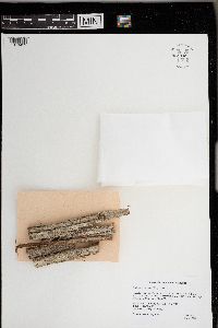 Inoderma byssaceum (Weigal) Gray 961149[1373419]Otto Gockman; Andy Kranz 055192017-07-24 United States, Minnesota, Cook, Superior National Forest. Approximately 4.36km west of Lutsen and 10.83km northeast of Tofte. On the trunk of a large (150+ year old) Thuja occidentalis at the base of Moose Mountain., 47.641129 -90.732194 |
MIN:Lichens | 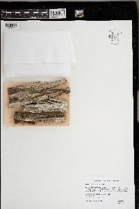 Inoderma byssaceum (Weigal) Gray 961147[1373421]Otto Gockman; Andy Kranz 055202017-07-24 United States, Minnesota, Cook, Superior National Forest. Approximately 4.82km west of Lutsen and 11.2km northeast of Tofte. On the trunk of a large (150+ year old) Thuja occidentalis at the base of Moose Mountain. Being parasitized by Chaenothecopsis brevipes., 47.650069 -90.738895 |
MIN:Lichens | 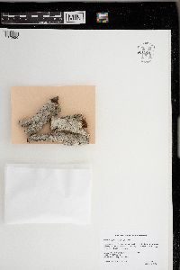 Inoderma byssaceum (Weigal) Gray 961146[1373420]Otto Gockman; Scott Milburn 055002017-09-08 United States, Minnesota, Aitkin, Approximately 6.97km northwest of McGrath and 16.63km east of Malmo. Growing on the lower trunks of a large Tilia americana in a mesic hardwood (MHn35) community., 46.296957 -93.310087 |
MIN:Lichens | 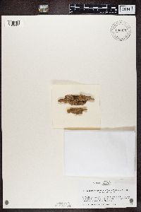 Inoderma nipponicum Frisch, Y. Ohmura & G. Thor 948935[1389809]Frisch, A. Japan |
1
Page 1, records 1-5 of 5
Google Map
Google Maps is a web mapping service provided by Google that features a map that users can pan (by dragging the mouse) and zoom (by using the mouse wheel). Collection points are displayed as colored markers that when clicked on, displays the full information for that collection. When multiple species are queried (separated by semi-colons), different colored markers denote each individual species.