University of Minnesota
http://www.umn.edu/
612-625-5000
http://www.umn.edu/
612-625-5000
Minnesota Biodiversity Atlas
Bell Museum
Dataset: USACE
Taxa: Alismataceae
Search Criteria: excluding cultivated/captive occurrences
1
Page 1, records 1-13 of 13
Biodiversity of the U.S. Army Corps of Engineers Mississippi Headwaters Recreation Area Sites | |
 USACE | Alisma subcordatum Rafinesque 4237[] 2019-06-26 United States, Minnesota, Aitkin, Sandy Lake Recreation Area; oxbow forest, 46.788547 -93.321442 |
USACE | Alisma subcordatum Rafinesque 1727941[] 2019-08-28 United States, Minnesota, Cass, Leech Lake Recreation Area; prairie ditch, 47.257642 -94.220845 |
USACE | Sagittaria latifolia Willdenow 3930[] 2019-06-25 United States, Minnesota, Itasca, Pokegama Dam Recreation Area; campground, 47.248838 -93.582245 |
USACE | Sagittaria latifolia Willdenow 4068[] 2019-06-24 United States, Minnesota, Cass, Leech Lake Recreation Area; rich fen, 47.2445 -94.229 |
USACE | Sagittaria latifolia Willdenow 4238[] 2019-06-26 United States, Minnesota, Aitkin, Sandy Lake Recreation Area; oxbow forest, 46.788547 -93.321442 |
USACE | Sagittaria latifolia Willdenow 4443[] 2019-06-28 United States, Minnesota, Crow Wing, Gull Lake Recreation Area; marsh, 46.411512 -94.354028 |
USACE | Sagittaria latifolia Willdenow 4603[] 2019-06-29 United States, Minnesota, Crow Wing, Cross Lake Recreation Area; shoreline-marsh, 46.6715 -94.1149 |
USACE | Sagittaria latifolia Willdenow 1727969[] 2019-08-29 United States, Minnesota, Itasca, Lake Winnibigoshish Recreation Area; point, 47.43237 -94.052647 |
USACE | 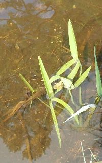 Sagittaria latifolia Willdenow 1728310[] 2021-06-28 United States, Minnesota, Crow Wing, Cross Lake Recreation Area; Four Acre Lake, 46.725 -94.130278 |
USACE | Sagittaria latifolia Willdenow 1728475[] 2021-06-29 United States, Minnesota, Crow Wing, Cross Lake Recreation Area; Arrowhead Lake; southest shore, 46.71894 -94.217704 |
USACE | 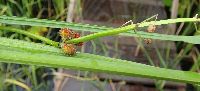 Sagittaria rigida Pursh 1727781[] 2019-08-26 United States, Minnesota, Itasca, Pokegama Dam, 47.248395 -93.58168 |
USACE | 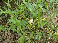 Sagittaria rigida Pursh 1727848[] 2019-08-27 United States, Minnesota, Aitkin, Sandy Lake Recreation Area; oxbow forest, 46.790727 -93.322957 |
USACE | 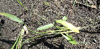 Sagittaria rigida Pursh 1728569[] 2021-08-23 United States, Minnesota, Crow Wing, Cross Lake Recreation Area; Four Acre Lake, 46.72 -94.12 |
1
Page 1, records 1-13 of 13
Google Map
Google Maps is a web mapping service provided by Google that features a map that users can pan (by dragging the mouse) and zoom (by using the mouse wheel). Collection points are displayed as colored markers that when clicked on, displays the full information for that collection. When multiple species are queried (separated by semi-colons), different colored markers denote each individual species.