University of Minnesota
http://www.umn.edu/
612-625-5000
http://www.umn.edu/
612-625-5000
Minnesota Biodiversity Atlas
Bell Museum
Dataset: NGBRC
Taxa: Maesa
Search Criteria: excluding cultivated/captive occurrences
1
Page 1, records 1-7 of 7
Plant records from the New Guinea Binatang Research Center | |
 NGBRC | 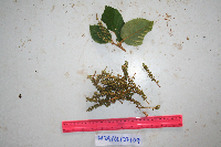 Maesa haplobotrys F.Muell. Ctvrtecka3827[]Ctvrtecka, R. 38272009-01-27 Papua New Guinea, Madang Province, Mis, -5.15 145.783, 10m |
NGBRC | Maesa haplobotrys F.Muell. NP1A0233[]Binatang Research Center NP1A02332014-10-27 Papua New Guinea, Madang, Numba, -5.7222 145.2714, 1200m |
NGBRC | 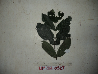 Maesa haplobotrys F.Muell. NP3B0528[]Binatang Research Center NP3B05282021-07-10 Papua New Guinea, Madang, Numba, -5.7222 145.2714, 1200m |
NGBRC | Maesa haplobotrys F.Muell. NS4A0584[]Binatang Research Center NS4A05842014-06-03 Papua New Guinea, Madang, Numba, -5.7222 145.2714, 1200m |
NGBRC | Maesa haplobotrys F.Muell. NS4A0588[]Binatang Research Center NS4A05882014-02-04 Papua New Guinea, Madang, Numba, -5.7222 145.2714, 1200m |
NGBRC | 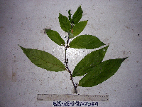 Maesa haplobotrys F.Muell. WS3E3059[]Binatang Research Center WS3E30592021-07-10 Papua New Guinea, Madang Province, Wanang, -5.229583 145.178467, 115m |
NGBRC | 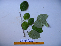 Maesa spectabilis Sleumer YS4F2155[]Binatang Research Center YS4F21552011-08-19 Papua New Guinea, Morobe Province, Yawan, -6.16255 146.839933, 1721m |
1
Page 1, records 1-7 of 7
Google Map
Google Maps is a web mapping service provided by Google that features a map that users can pan (by dragging the mouse) and zoom (by using the mouse wheel). Collection points are displayed as colored markers that when clicked on, displays the full information for that collection. When multiple species are queried (separated by semi-colons), different colored markers denote each individual species.