University of Minnesota
http://www.umn.edu/
612-625-5000
http://www.umn.edu/
612-625-5000
Minnesota Biodiversity Atlas
Bell Museum
Dataset: NGBRC
Taxa: Microsorum
Search Criteria: excluding cultivated/captive occurrences
1
Page 1, records 1-7 of 7
Plant records from the New Guinea Binatang Research Center | |
 NGBRC | 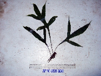 Microsorum rampans (Baker) Parris WP4C2886[]Binatang Research Center WP4C28862007-07-18 Papua New Guinea, Madang Province, Wanang, -5.2373 145.177183, 115m |
NGBRC | Microsorum rampans (Baker) Parris YS1H3522[]Binatang Research Center YS1H35222012-04-12 Papua New Guinea, Morobe Province, Yawan, -6.1641 146.843567, 1851m |
NGBRC | Microsorum rampans (Baker) Parris YS1H3527[]Binatang Research Center YS1H35272013-05-09 Papua New Guinea, Morobe Province, Yawan, -6.1641 146.843567, 1851m |
NGBRC | 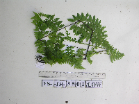 Microsorum rampans (Baker) Parris YS1H3501[]Binatang Research Center YS1H35012013-05-09 Papua New Guinea, Morobe Province, Yawan, -6.1641 146.843567, 1851m |
NGBRC | Microsorum rampans (Baker) Parris YS1H3535[]Binatang Research Center YS1H35352013-04-26 Papua New Guinea, Morobe Province, Yawan, -6.1641 146.843567, 1851m |
NGBRC | Microsorum rampans (Baker) Parris YS1H3536[]Binatang Research Center YS1H35362013-04-04 Papua New Guinea, Morobe Province, Yawan, -6.1641 146.843567, 1851m |
NGBRC | Microsorum rampans (Baker) Parris YS1H3555[]Binatang Research Center YS1H35552013-05-24 Papua New Guinea, Morobe Province, Yawan, -6.1641 146.843567, 1851m |
1
Page 1, records 1-7 of 7
Google Map
Google Maps is a web mapping service provided by Google that features a map that users can pan (by dragging the mouse) and zoom (by using the mouse wheel). Collection points are displayed as colored markers that when clicked on, displays the full information for that collection. When multiple species are queried (separated by semi-colons), different colored markers denote each individual species.