University of Minnesota
http://www.umn.edu/
612-625-5000
http://www.umn.edu/
612-625-5000
Minnesota Biodiversity Atlas
Bell Museum
Dataset: NGBRC
Taxa: Trophis
Search Criteria: excluding cultivated/captive occurrences
1
Page 1, records 1-6 of 6
Plant records from the New Guinea Binatang Research Center | |
 NGBRC | 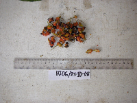 Trophis scandens (Lour.) Hook & Arn. Ctvrtecka2850[]Ctvrtecka, R. 28502008-10-23 Papua New Guinea, Madang Province, Wanang, -5.23088 145.182, 115m |
NGBRC | Trophis scandens (Lour.) Hook & Arn. NS4A0606[]Binatang Research Center NS4A06062014-03-14 Papua New Guinea, Madang, Numba, -5.7222 145.2714, 1200m |
NGBRC | 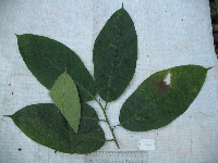 Trophis philippinensis (Bur.) Corner PA5D0282[]Binatang Research Center PA5D02822016-12-28 Papua New Guinea, Madang Province, Wanang, -5.237483 145.115733, 129m |
NGBRC | Trophis philippinensis (Bur.) Corner WC08C2063[]Binatang Research Center WC08C20632014-12-12 Papua New Guinea, Madang Province, Wanang Conservation, -5.222222 145.111111, 150m |
NGBRC | Trophis scandens (Lour.) Hook & Arn. WP1Z3201[]Binatang Research Center WP1Z32012009-12-01 Papua New Guinea, Madang Province, Wanang, -5.2373 145.177183, 115m |
NGBRC | 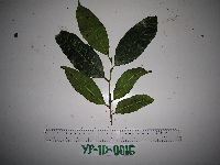 Trophis philippinensis (Bur.) Corner YP1D0016[]Binatang Research Center YP1D00162013-01-17 Papua New Guinea, Morobe Province, Yawan, -6.1642 146.840083, 1738m |
1
Page 1, records 1-6 of 6
Google Map
Google Maps is a web mapping service provided by Google that features a map that users can pan (by dragging the mouse) and zoom (by using the mouse wheel). Collection points are displayed as colored markers that when clicked on, displays the full information for that collection. When multiple species are queried (separated by semi-colons), different colored markers denote each individual species.