University of Minnesota
http://www.umn.edu/
612-625-5000
http://www.umn.edu/
612-625-5000
Minnesota Biodiversity Atlas
Bell Museum
Dataset: JFBM-Fishes
Taxa: Esox
Search Criteria: excluding cultivated/captive occurrences
Bell Museum fishes | |
 JFBM:Fishes |  36635[]Niemela, Scott 2000-07-12 United States, Minnesota, Itasca, Pigeon Creek, downstream of culvert off Forest Road 2382, 47.58833828 -94.18702113 |
JFBM:Fishes |  45910[]Berendzen, Peter; Tang, Kevin; Yuvaraj, Krshna 2001-03-24 United States, Tennessee, Henry, Blood River at Red Top Hill Road, 1 mile North of Buchanan, 36.4733333 -88.1955556 |
JFBM:Fishes |  43424[]Niemela, Scott 2004-09-08 United States, Minnesota, Washington, St. Croix River downstream of Otisville boat access, 45.2430573 -92.7597198 |
JFBM:Fishes | 8127[]Eddy, Samuel; Survey Crew 1936-07-02 United States, Minnesota, St. Louis, Side Lake, 47.67269 -93.02019 |
JFBM:Fishes |  40178[]Simons, Andrew; Egge, Jacob; Vincent, Donnie; Seroogy, Matthew 2002-05-30 United States, Arkansas, Grant, Saline River at US Highway 270, 1.5 miles W of Prattville, 34.3119431 -92.5902786 |
JFBM:Fishes |  37158[]Minnesota Pollution Control Agency 1998-08-11 United States, Minnesota, St. Louis, Cloquet River at County State Aid Highway 44 to State Forest Road heading W, 1 mile W of Bear Lake, 47.20753114 -91.94208725 |
JFBM:Fishes |  39840[]Feist, Mike; Schmidt, Konrad 2001-08-14 United States, Minnesota, Redwood, Pell Creek, 3 miles NW of Lamberton, 1.5 miles N of US Highway 14, 44.2508316 -95.3261108 |
JFBM:Fishes |  38118[]Dahle, Shawn 2001-08-18 United States, Minnesota, Pipestone, Unnamed Tributary to Pipestone Creek at County Road 13, 3.5 miles NW of Ihlen, 43.9319458 -96.4274979 |
JFBM:Fishes |  17167[]Massmann, W.; Ogelsby, R. 1953-10-01 United States, Virginia, Suffolk City/Chesapeake City, Lake Drummond, Dismal Swamp, 36.60283 -76.46974 |
JFBM:Fishes |  45238[]Simons, Andrew; Wolfe, Rene; Gidmark, Nick; Pederson, Ryan 2005-06-15 United States, Alabama, Bibb, Blue Girth Creek along Palmertown Road, ca. 2 km SE of Pondville, 32.89 -87.2991667 |
JFBM:Fishes |  42416[]Egge, Jacob; Berendzen, Peter; Nagle, Brett 2004-07-09 United States, North Carolina, Granville/Franklin, Tar River at Charlie Grissom Rd (Green Hill Rd), State Road 1101/State Road 1203, 11 miles southwest of Henderson, 36.1753 -78.4963 |
JFBM:Fishes |  36236[]Minnesota Pollution Control Agency 2000-07-12 United States, Minnesota, Itasca, Third River upstream of Forest Road 2171, 47.54456022 -94.26143617 |
JFBM:Fishes |  36862[]Schmidt, Konrad; Class, Leah 2000-06-26 United States, Minnesota, Stearns, South Fork Watab River, upstream of County Road 50, 8 miles S of Avon, 45.54329236 -94.445263 |
JFBM:Fishes | 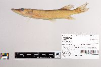 39706[]Feist, Mike; Schmidt, Konrad 2001-08-07 United States, Minnesota, Faribault, Blue Earth River upstream of County Road 5, 3 miles S of Winnebago, 43.7244453 -94.1538925 |
JFBM:Fishes | 8130[] 1936-07-02 United States, Minnesota, Itasca, Island Lake, Dora Lake District, 47.81189 -94.23685 |
JFBM:Fishes | 46011[]Hallock, M. 2009-10-29 United States, Minnesota, Otter Tail, West Battle Lake, 46.29571 -95.65521 |
JFBM:Fishes | 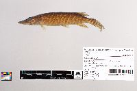 40386[]Talmage, Phil 2001-08-28 United States, Minnesota, Swift, Cottonwood Creek E of County Road 65, 5 mi SE of Holloway, 45.1772232 -95.816391 |
JFBM:Fishes | 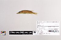 37177[]Minnesota Pollution Control Agency 1998-08-19 United States, Minnesota, St. Louis, tributary to the St. Louis River, just upstream of County-State-Aid-Highway 4, at County-State-Aid-Highway 111, 8 miles S of Biwabik, 47.41500376 -92.29581518 |
JFBM:Fishes | 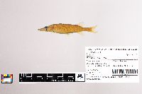 40881[]Simons, Andrew; Egge, Jacob; Vincent, Donnie; Seroogy, Matthew 2002-05-30 United States, Arkansas, Bradley, Saline River at US Hwy 63, 6 mi N of Warren, 33.6930542 -92.0308304 |
JFBM:Fishes |  36202[]Feist, Mike; Talmage, Phil 2000-09-18 United States, Minnesota, Isanti, Rum River downstream of County Road 5, in Isanti, 45.49079518 -93.26489795 |
JFBM:Fishes |  39212[]Talmage, Phil 2001-07-12 United States, Minnesota, Faribault, Branch Creek downstream of County Road 2, 1.5 miles E of Brialyn, 43.5552788 -93.7755585 |
JFBM:Fishes |  17147[]Massmann, W. 1952-06-10 United States, Virginia, Chesapeake City, Mouth of Portsmouth Ditch, Lake Drummond, Dismal Swamp, 36.60685 -76.44817 |
JFBM:Fishes |  36463[]Feist, Mike 2000-08-03 United States, Minnesota, Anoka, Rice Creek, downstream of University Avenue (Highway 47), 45.09004468 -93.26710551 |
JFBM:Fishes |  40450[]Feist, Mike; Niemela, Scott 2001-09-13 United States, Minnesota, Swift, Pomme de Terre River upstream of County Road 51, 2.5 miles W of Appleton, 45.1986122 -96.0738907 |
JFBM:Fishes |  20639[]Myer, T. 1971-09-15 United States, Minnesota, Otter Tail, Battle Lake Hatchery |
JFBM:Fishes |  38339[]Simons, Andrew; Berendzen, Peter; Nagle, Brett 2001-06-28 United States, Kentucky, Clay, Red Bird River at State Road 149, 1 mile NW of Eriline, 37.1952782 -83.6158371 |
JFBM:Fishes |  44860[]Schmidt, Konrad 2006-05-26 United States, Minnesota, Hennepin, Long Meadow Lake, Minnesota Valley National Wildlife Refuge, 44.8325 -93.23616 |
JFBM:Fishes |  39722[]Schmidt, Konrad 2001-08-06 United States, Minnesota, Watonwan, Watonwan River downstream of county road 16, 5 mi W of Madelia, 44.0552788 -94.5322189 |
JFBM:Fishes |  41812[]Bartels, Andy 1990-05-02 United States, Wisconsin, La Crosse, Mississippi River, Pool 8, below spillway on Black River, 4.7 miles NE of La Crescent, 43.877224 -91.2394409 |
JFBM:Fishes |  35216[]Schmidt, Konrad 2000-08-22 United States, Minnesota, Aitkin, Rice River upstream of culvert off Through Highway 152 bridge, 2 miles E of Kimberly, 46.55009651 -93.42094224 |
JFBM:Fishes |  45774[]Simons, Andrew; Ghedotti, Michael; Halas, Dominik; Hirt, Michael 2007-07-14 United States, Arkansas, Saline, Ten Mile Creek at U.S. Highway 70, 1 mile Southwest of Nance, 34.5455556 -92.7538889 |
JFBM:Fishes |  43541[]Niemela, Scott 2004-09-14 United States, Minnesota, Chisago, St. Croix River, 1 mile downstream of Osceola, 45.314167 -92.7188873 |
JFBM:Fishes | 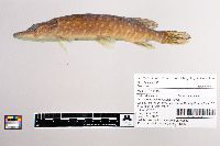 35261[]Minnesota Pollution Control Agency 2000-07-10 United States, Minnesota, Otter Tail, Wing River upstream of County Road 42, ca. 7.5 miles N of Parkers Prairie, 46.22554784 -95.21055748 |
JFBM:Fishes | 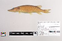 39628[]Feist, Mike; Niemela, Scott 2001-07-25 United States, Minnesota, Martin, Center Creek downstream of North Ave, Fairmont treatment plant, in Fairmont, 43.67137022 -94.45941971 |
JFBM:Fishes | 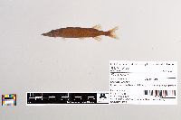 45133[]Simons, Andrew; Peterson, Ryan; Wolfe, Rene; Gidmark, Nick 2005-06-15 United States, Alabama, Bibb, Lightsey's Mill Pond, ca. 4 km SSE of Centreville, 32.9094444 -87.1216667 |
JFBM:Fishes | 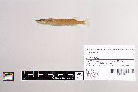 35709[]Talmage, Phil 2000-06-06 United States, Minnesota, Stearns, County Ditch 12 upstream of County Road 4, 45.62373109 -94.3002826 |
JFBM:Fishes |  40029[]Feist, Mike; Niemela, Scott 2001-07-18 United States, Minnesota, Lac Qui Parle, Ten Mile Creek upstream of US Hwy 212, 5 mi N of Boyd, 44.9174995 -95.8769455 |
JFBM:Fishes |  36308[]Schmidt, Konrad 2000-08-01 United States, Minnesota, Hubbard, Mississippi River, downstream of Stumphages Rapids, 47.39753996 -95.14622944 |
JFBM:Fishes |  35534[]Niemela, Scott; Minnesota Pollution Control Agency 2000-08-15 United States, Minnesota, Stearns, Sauk River upstream of confluence with Adley Creek on County Road 168, in Melrose, 45.68154959 -94.77174856 |
JFBM:Fishes |  44699[]Nagle, Brett; Egge, Jacob; Hundt, Peter; Halas, Dominik 2006-08-30 United States, Missouri, Oregon, Eleven Point River at County Road 142, ca. 1 mile W of Cahn, 36.5508333 -91.1941667 |
JFBM:Fishes |  39155[]Feist, Mike; Schmidt, Konrad 2001-07-18 United States, Minnesota, Lac Qui Parle, Lac Qui Parle River, downstream of county road 16, 2 mi NE of Dawson, 44.9583321 -96.0227814 |
JFBM:Fishes |  46478[]Kelly, Michael; Scholl, R. 2010-09-21 United States, Minnesota, Koochiching, Big Fork River, downstream of Highway 6, 15.5 miles South of Big Falls, 47.9647222 -93.7802778 |
JFBM:Fishes |  36732[]Feist, Mike; Niemela, Scott 2000-09-14 United States, Minnesota, Sherburne, Mississippi River at Monticello public access, 45.30466213 -93.78224182 |
JFBM:Fishes |  36938[]Carter, Chandra 2000-08-24 United States, Minnesota, Todd, Crooked Lake Ditch, downstream of County Road 85, 4 miles N of Osakis, 45.92931405 -95.13733218 |
JFBM:Fishes | 8114[] 1936-07-08 United States, Minnesota, Cass, Lake Winnibigoshish, Bena District, 47.39974 -94.20982 |
JFBM:Fishes |  43004[]Simons, Andrew; Kuhajda, Bernard; Ghedotti, Michael; Nagle, Brett; Egge, Jacob 2004-08-12 United States, Alabama, Bibb, Blue Girth Creek on Palmertown Rd, 2 km SE of Pondville, 32.8899994 -87.2991638 |
JFBM:Fishes |  39108[]Feist, Mike; Schmidt, Konrad 2001-08-08 United States, Minnesota, Watonwan, South Fork Watonwan River downstream of Highway 60 at Wayside rest, 5 miles E of St. James |
JFBM:Fishes |  36707[]Feist, Mike; Schmidt, Konrad 2000-08-01 United States, Minnesota, Wadena, Shell River at Shell City Landing, 46.79254221 -94.94644943 |
JFBM:Fishes |  46310[]Simons, Andrew; Halas, Dominik; Hundt, Peter; Young, Brett 2010-07-06 United States, Mississippi, Yalobusha, Unnamed creek at Airmount W Road (County Road 135) ca. 14 km due E of Coffeyville, 33.9616667 -89.5263333 |
JFBM:Fishes |  39395[]Feist, Mike; Schmidt, Konrad 2001-07-02 United States, Minnesota, Lac Qui Parle, Ten Mile Creek upstream of US Highway 212, 5 miles N of Boyd, 44.91759048 -95.87735153 |
JFBM:Fishes |  35964[]Schmidt, Konrad 1994-10-01 United States, Wisconsin, Iowa, Wisconsin River, back channel along road to public access about 1 mile north of Arena, 43.1805573 -89.9061127 |
JFBM:Fishes |  36405[]Feist, Mike 2000-07-06 United States, Minnesota, Crow Wing, Little Buffalo Creek downstream of Highway 371, 46.34243124 -94.20191545 |
JFBM:Fishes |  39415[]Niemela, Scott; Schmidt, Konrad 2001-08-15 United States, Minnesota, Redwood, Redwood River downstream of E Oak Street, in Ramsey Park, in Redwood Falls, 44.55303725 -95.1238904 |
JFBM:Fishes |  37380[]Minnesota Pollution Control Agency 1998-06-24 United States, Minnesota, Kanabec, Mud Creek just upstream of State Highway 23 on SE side of Quamba, 45.91266006 -93.17565692 |
JFBM:Fishes |  36965[]Feist, Mike 2000-07-18 United States, Minnesota, Chisago, Rush Creek, access at address 380 County Road 55, 0.2 miles E of Rush City, 45.68539765 -92.9542005 |
JFBM:Fishes |  37284[]Minnesota Pollution Control Agency 1998-08-19 United States, Minnesota, St. Louis, Spider Muskrat Creek just upstream of County-State-Aid-Highway 5, 5.5 miles S of Meadowlands, 47.00030594 -92.74162612 |
JFBM:Fishes |  42703[]Simons, Andrew; Ghedotti, Michael; Egge, Jacob; Nagle, Brett 2004-08-07 United States, Tennessee, Chester, Clark's Creek at Holly Springs Road, ca. 6 km NNE of Henderson, 35.4911118 -88.5911102 |
JFBM:Fishes |  39910[]Niemela, Scott 2001-08-07 United States, Minnesota, Watonwan, Perch Creek upstream of county road 10, 6 mi SE of Madelia, 43.9730568 -94.3413925 |
JFBM:Fishes | 8129[]Eddy, Samuel; Survey Crew 1936-07-02 United States, Minnesota, St. Louis, Side Lake, 47.67269 -93.02019 |
JFBM:Fishes |  12207[]Kenyon, W. 1941-08-22 United States, Minnesota, Cook, Falls Creek, 47.91674 -90.29105 |
JFBM:Fishes | 27402[]MN Historical Society 1993-00-00 United States, Minnesota, Roseau, Lake of the Woods |
JFBM:Fishes | 11071[] 1938-00-00 United States, Minnesota, Hubbard, Belle Taine Lake (Elbow Lake), Nevis, 46.93948 -94.88068 |
JFBM:Fishes | 8138[]Douglas, J. 1936-07-03 United States, Minnesota, St. Louis, Side Lake, 47.67269 -93.02019 |
JFBM:Fishes | 7769[] 1936-07-08 United States, Minnesota, Itasca, Big Bear Lake, 47.66955 -93.26817 |
JFBM:Fishes | 11225[]Eddy, Samuel; Conservation Corps Survey Crew 1936-07-08 United States, Minnesota, Cass, Lake Winnibigoshish, 47.44388 -94.18991 |
JFBM:Fishes | 10907[] 1936-08-14 United States, Minnesota, Itasca, Maple Lake, 4 miles NE of Marcell, 47.64748 -93.72214 |
JFBM:Fishes | 7815[] 1936-08-04 United States, Minnesota, Itasca, Caribou Lake, Marcelle District, 47.52803 -93.63788 |
JFBM:Fishes | 7816[] 1936-08-05 United States, Minnesota, Itasca, Caribou Lake, Marcelle District, 47.52803 -93.63788 |
JFBM:Fishes | 3040[] 1931-10-00 United States, Minnesota, Hennepin, Hoover Bass Pond, 44.84735 -93.22535 |
JFBM:Fishes | 7705[]Hiner, L. 1936-09-15 United States, Minnesota, Cass, Cass Lake, Pike Bay, 47.34718 -94.57359 |
JFBM:Fishes | 7708[]Hiner, L. 1936-09-15 United States, Minnesota, Cass, Cass Lake, Pike Bay, 47.34718 -94.57359 |
JFBM:Fishes | 7813[] 1936-08-10 United States, Minnesota, Itasca, Ruby Lake, Marcelle District, 47.51824 -93.5527 |
JFBM:Fishes | 7820[] 1936-08-12 United States, Minnesota, Itasca, North Star Lake, Marcelle district, 47.55512 -93.66378 |
JFBM:Fishes | 7817[]Eddy, Samuel; Survey Crew 1936-08-11 United States, Minnesota, Itasca, North Star Lake, Marcelle District, 47.55512 -93.66378 |
JFBM:Fishes | 7818[]Eddy, Samuel; Survey Crew 1936-08-11 United States, Minnesota, Itasca, North Star Lake, Marcelle District, 47.55512 -93.66378 |
JFBM:Fishes | 7722[]Hiner, L. 1936-09-15 United States, Minnesota, Cass, Cass Lake, Pike Bay, 47.34718 -94.57359 |
JFBM:Fishes | 7707[]Hiner, L. 1936-09-15 United States, Minnesota, Cass, Cass Lake, Pike Bay, 47.34718 -94.57359 |
JFBM:Fishes |  27595[]United States Geological Survey; Minnesota Pollution Control Agency 1994-08-22 United States, Minnesota, Norman, South Branch Wild Rice River at County Road 136, ca. 3 miles SSE of Borup, 47.17314 -96.56416 |
JFBM:Fishes |  12635[]Minnesota Department of Conservation 1941-07-27 United States, Minnesota, St. Louis, Whiteface River |
JFBM:Fishes |  13261[]Minnesota Department of Conservation 1941-09-23 United States, Minnesota, St. Louis, McCarty Creek |
JFBM:Fishes |  13333[]Minnesota Department of Conservation 1941-07-09 United States, Minnesota, St. Louis, White Face River |
JFBM:Fishes |  13491[]Minnesota Department of Conservation 1941-07-27 United States, Minnesota, St. Louis, White Face River |
JFBM:Fishes |  13214[]Minnesota Department of Conservation 1941-07-16 United States, Minnesota, St. Louis, Waterhen Creek |
JFBM:Fishes |  13295[]Minnesota Department of Conservation 1941-07-25 United States, Minnesota, St. Louis, Whiteface River |
JFBM:Fishes |  13329[]Minnesota Department of Conservation 1941-07-02 United States, Minnesota, St. Louis, Hellwig Creek |
JFBM:Fishes |  13079[]Kenyon, W. 1941-07-26 United States, Minnesota, Cook, Poplar River off County Road 5, 47.66325 -90.716 |
JFBM:Fishes | 13361[]Minnesota Department of Conservation 1941-07-08 United States, Minnesota, Lake, Wanless Creek between Cliff Lake and Pickerel Lake, 9.5 miles SE of Sawbill Landing, 47.63873 -91.0928 |
JFBM:Fishes |  13300[]Minnesota Department of Conservation 1941-07-18 United States, Minnesota, St. Louis, Comstock Lake, 47.22023 -92.22344 |
JFBM:Fishes |  13247[]Minnesota Department of Conservation 1941-07-17 United States, Minnesota, St. Louis, Mud Hen Creek |
JFBM:Fishes |  13470[]Kenyon, W.; Karolyn, J. 1941-07-31 United States, Minnesota, Cook, Poplar River, station 5d, above cold springs stream, below beaver pond, 47.76137 -90.80964 |
JFBM:Fishes |  12135[]Kenyon, W. 1941-07-22 United States, Minnesota, Cook, Temperance River |
JFBM:Fishes |  12548[]Minnesota Department of Conservation 1941-08-22 United States, Minnesota, St. Louis, St. Louis River |
JFBM:Fishes |  13381[]Moore, W. 1941-06-23 United States, Minnesota, Crow Wing, Kenney Lake, 46.32378 -93.84888 |
JFBM:Fishes |  19807[]Meehean, A. 1929-09-28 United States, Minnesota, Winona, LaMoille Island, lower Gibbs slough, 44.00418 -91.46118 |
JFBM:Fishes |  19811[]Eddy, Samuel; Johnson, Ray 1947-08-15 United States, Wisconsin, La Crosse, Mississippi River, slough near LaCrosse, 43.76118 -91.24489 |
JFBM:Fishes |  8764[] 1900-00-00 United States, Minnesota, Winona, Homer, 44.02135 -91.55654 |
JFBM:Fishes |  11276[] 1940-09-00 United States, Minnesota, Lake of the Woods, Lake of the Woods, 49.27497 -94.71863 |
JFBM:Fishes |  11087[]Surber, Thaddeus 1932-09-00 United States, Minnesota, Hubbard, Belle Taine Lake (Elbow Lake), Nevis, 46.93948 -94.88068 |
JFBM:Fishes |  10784[] 1935-07-01 United States, Minnesota, Cook, Saganaga Lake, 48.24205 -90.92216 |
JFBM:Fishes |  3037[] |
Google Map
Google Maps is a web mapping service provided by Google that features a map that users can pan (by dragging the mouse) and zoom (by using the mouse wheel). Collection points are displayed as colored markers that when clicked on, displays the full information for that collection. When multiple species are queried (separated by semi-colons), different colored markers denote each individual species.