University of Minnesota
http://www.umn.edu/
612-625-5000
http://www.umn.edu/
612-625-5000
Minnesota Biodiversity Atlas
Bell Museum
Dataset: JFBM-Fishes
Taxa: Salmo
Search Criteria: excluding cultivated/captive occurrences
1
Page 1, records 1-83 of 83
Bell Museum fishes | |
 JFBM:Fishes |  43732[]Feist, Mike; Niemela, Scott 2004-08-12 United States, Minnesota, Houston, Riceford Creek, 2 miles N of Riceford, 43.5813904 -91.7275009 |
JFBM:Fishes |  35975[]Schmidt, Konrad 2000-10-13 United States, Minnesota, Goodhue, Cannon River upstream of County Highway 20 in Cannon Falls, 44.5133324 -92.9091644 |
JFBM:Fishes | 44413[]Minnesota Department of Natural Resources 1984-08-14 United States, Minnesota, Cook, St Louis Bay at Park Point 4.2 mi SE of Duluth, 46.73161 -92.05575 |
JFBM:Fishes |  41976[]Talmage, Phil 2002-05-30 United States, Minnesota, Fillmore, Root River station 06 (Peterson canoe access) River mile 40.5, 43.7813873 -91.8249969 |
JFBM:Fishes |  43609[]Carter, Chandra 2004-07-06 United States, Minnesota, Dakota, Pine Creek, upstream of 280th Street, 1.5 miles N of Cannon Falls, 44.5467436 -92.90237794 |
JFBM:Fishes | 41813[]Bartels, Andy 1993-10-05 United States, Wisconsin, Vernon, Mississippi River, Pool 8, Coon Creek Delta, River Mile 683.7, 3.4 miles NE of Reno, 43.6313896 -91.2213898 |
JFBM:Fishes | 44422[]Minnesota Department of Natural Resources 1987-05-27 United States, Minnesota, St. Louis, Lester River in Duluth, 46.83904 -92.00679 |
JFBM:Fishes |  41456[]Bartels, Andy 1998-06-29 United States, Minnesota, Houston, Mississippi River, Pool 8, Station M22.RS at River Mile 681.2, 1 mile E of Reno, 43.5974998 -91.2558365 |
JFBM:Fishes | 8291[] 1936-08-06 United States, Minnesota, Itasca, Lucky Lake, Marcelle District, 47.42765 -93.61678 |
JFBM:Fishes | 8292[] 1936-08-06 United States, Minnesota, Itasca, Lucky Lake, Marcelle District, 47.42765 -93.61678 |
JFBM:Fishes | 8293[] 1936-08-06 United States, Minnesota, Itasca, Lucky Lake, Marcelle District, 47.42765 -93.61678 |
JFBM:Fishes | 8294[] 1936-08-06 United States, Minnesota, Itasca, Lucky Lake, Marcelle District, 47.42765 -93.61678 |
JFBM:Fishes |  11713[]Moyle, John 1940-07-31 United States, Minnesota, St. Louis, Lester River at County Road 37 |
JFBM:Fishes |  11714[]Minnesota Department of Conservation 1940-07-12 United States, Minnesota, Lake, Gooseberry River, Station 3, at County Road 3, 47.17793 -91.57456 |
JFBM:Fishes |  11719[] 1940-08-15 United States, Minnesota, Lake, Ninemile Creek, 47.50943 -91.10842 |
JFBM:Fishes |  14158[]Moyle, John 1940-07-18 United States, Minnesota, Lake, Split Rock River |
JFBM:Fishes | 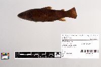 14584[] 1942-07-12 United States, Minnesota, St. Louis, Otter River |
JFBM:Fishes | 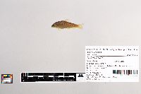 23638[]Ashmun, H.; McCormack, David 1983-08-26 United States, Minnesota, Lake, unnamed tributary to East Branch Baptism River, at County Road 7, 47.43447 -91.22103 |
JFBM:Fishes | 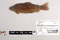 23909[]Wallow and McCormack; Wallmow, Rollo; McCormack, David 1985-07-09 United States, Minnesota, Cottonwood, Unnamed tributary to Des Moines River, 7 Miles NW of Windom, 43.94142 -95.21147 |
JFBM:Fishes | 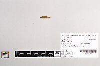 27422[]Schmidt, Konrad 1993-05-14 United States, Minnesota, Chisago, Lawrence Creek, at mouth, 45.36141 -92.70125 |
JFBM:Fishes |  26980[]Schmidt, Konrad 1993-08-07 United States, Minnesota, Fillmore, South Branch Root River at Seven Springs, 43.62511 -92.28245 |
JFBM:Fishes |  27532[]Schmidt, Konrad 1994-05-03 United States, Minnesota, Winona, Beaver Creek, 44.14514 -92.05599 |
JFBM:Fishes |  27392[]Schmidt, Konrad 1993-10-18 United States, Minnesota, Carlton, Blackhoof River at County Road 103, 46.52863 -92.47038 |
JFBM:Fishes |  27718[]Schmidt, Konrad 1994-05-29 United States, Minnesota, Scott, Eagle Creek at County Road 101 bridge, 44.77982 -93.38284 |
JFBM:Fishes |  27581[]Schmidt, Konrad 1994-07-27 United States, Minnesota, Wabasha, Trout Creek, Whitewater Wildlife Management Area, ca. 6 km NW of Minneiska, 44.1963 -91.9408 |
JFBM:Fishes |  27525[]Schmidt, Konrad 1994-05-03 United States, Minnesota, Wabasha, Trout Creek, Whitewater Wildlife Management Area, 44.19636 -91.94089 |
JFBM:Fishes |  27514[]Schmidt, Konrad 1994-06-01 United States, Minnesota, Winona, Trout Creek at County Road 31, 44.18867 -91.93016 |
JFBM:Fishes |  27562[]Schmidt, Konrad 1994-06-01 United States, Minnesota, Winona, North Fork Whitewater River, 2.25 miles W of Elba, 44.09338 -92.06105 |
JFBM:Fishes |  27853[]Schmidt, Konrad 1994-07-27 United States, Minnesota, Olmsted, South Branch North Fork Whitewater River, ca. 2 miles N of Little Valley, 44.10361 -92.1377 |
JFBM:Fishes |  27793[]Schmidt, Konrad 1994-09-29 United States, Minnesota, Wabasha, Whitewater River at US Highway 61, Whitewater Wildlife Management Area, 44.20857 -91.92271 |
JFBM:Fishes |  32525[]Schmidt, Konrad 1994-06-01 United States, Minnesota, Winona, Whitewater River at County Road 26, Whitewater Wildlife Management Area, 44.09165 -92.01307 |
JFBM:Fishes |  32521[]Schmidt, Konrad 1994-06-01 United States, Minnesota, Winona, Whitewater River at County Road 30, Whitewater Wildlife Management Area, 44.171 -92.00037 |
JFBM:Fishes |  27519[]Schmidt, Konrad 1994-06-01 United States, Minnesota, Winona, Whitewater River at State Highway 74, Whitewater Wildlife Management Area, 44.0792 -92.02852 |
JFBM:Fishes |  32506[]Schmidt, Konrad 1994-06-01 United States, Minnesota, Winona, South Fork Whitewater River, Whitewater Wildlife Management Area, 44.00813 -91.99925 |
JFBM:Fishes |  27528[]Schmidt, Konrad 1994-06-01 United States, Minnesota, Winona, South Fork of Whitewater River at County Road 26, 44.09011 -91.9984 |
JFBM:Fishes |  27932[]Schmidt, Konrad 1994-07-27 United States, Minnesota, Winona, Middle Fork Whitewater River, Whitewater River Wildlife Management Area, 44.05379 -92.05736 |
JFBM:Fishes |  28836[]Minnesota Pollution Control Agency 1997-07-02 United States, Minnesota, St. Louis, tributary to Lester River, NW of County Road 259 and County Road 293 intersection, 2.5 miles N of Duluth, 46.89759952 -92.01001239 |
JFBM:Fishes |  28893[]Minnesota Pollution Control Agency 1997-08-13 United States, Minnesota, Carlton, Blackhoof River, just west of County Road 104 bridge, 6 miles SW of Wrenshall, 46.56999 -92.48879 |
JFBM:Fishes |  28899[]Minnesota Pollution Control Agency 1997-08-12 United States, Minnesota, St. Louis, Cloquet River, just W of Highway 33, before it turns into Highway 53, 5.5 miles E of Alborn, 46.95288254 -92.46603508 |
JFBM:Fishes |  29829[]Minnesota Pollution Control Agency 1998-08-05 United States, Minnesota, Cook, Swamp River, County-State-Aid-Highway 16 to State Forest Road road heading E, site is downstream of bridge crossing, 10 mi N of Hovland, 47.9889331 -89.9344258 |
JFBM:Fishes |  29791[]Minnesota Pollution Control Agency 1998-08-13 United States, Minnesota, Pine, Wolf Creek downstream of E unnamed gravel road, off Highway 22, 7 miles SE of Askov, 46.15550557 -92.6313779 |
JFBM:Fishes |  29457[]Minnesota Pollution Control Agency 1997-07-02 United States, Minnesota, St. Louis, tributary to Lester River, NW of County Road 259 and County Road 293 intersection, 2.5 miles N of Duluth, 46.89759952 -92.01001239 |
JFBM:Fishes |  29458[]Minnesota Pollution Control Agency 1997-08-13 United States, Minnesota, Carlton, Blackhoof River, just west of County Road 104 bridge, 6 miles SW of Wrenshall, 46.56999 -92.48879 |
JFBM:Fishes |  30551[]Schmidt, Konrad 1999-06-22 United States, Minnesota, Washington, Browns Creek upstream of Highway 95, 45.434999 -92.4837036 |
JFBM:Fishes |  30562[]Schmidt, Konrad 1999-08-20 United States, Minnesota, Washington, Old Mill Stream, upstream of Highway 95, 45.1151009 -92.4617004 |
JFBM:Fishes |  30701[]Schmidt, Konrad 1999-06-18 United States, Minnesota, Washington, Trout Brook, upstream of old Rail Road (now trail) and downstream of Afton Alps, 44.5130005 -92.4633026 |
JFBM:Fishes |  30707[]Schmidt, Konrad 1999-09-01 United States, Minnesota, Washington, Gilbertson Creek, from mouth to barrier falls, near Otisville, 45.24033 -92.76083 |
JFBM:Fishes |  30710[]Schmidt, Konrad 1999-06-24 United States, Minnesota, Washington, Valley Branch, upstream of County Road 21, 44.553299 -92.486 |
JFBM:Fishes |  30721[]Schmidt, Konrad 1999-06-22 United States, Minnesota, Washington, Valley Branch, upstream of Putnam Road, in Afton, 44.55 -92.4713889 |
JFBM:Fishes |  30722[]Schmidt, Konrad 1999-06-22 United States, Minnesota, Washington, Valley Branch, upstream of Putnam Road, in Afton, 44.55 -92.4713889 |
JFBM:Fishes |  30893[]Schmidt, Konrad 1999-06-27 United States, Minnesota, Dakota, Pine Creek, upstream of 280th Street, 44.54344 -92.90043 |
JFBM:Fishes |  30896[]Schmidt, Konrad 1999-06-19 United States, Minnesota, Goodhue, Pine Creek downstream of County Road 17, 44.532 -92.87353 |
JFBM:Fishes |  30902[]Schmidt, Konrad 1999-06-19 United States, Minnesota, Dakota, Trout Brook, Dakota County Park, 44.54412 -92.80443 |
JFBM:Fishes |  30726[]Schmidt, Konrad 1999-06-24 United States, Minnesota, Washington, tributary to Valley Branch, upstream of County Road 21, 1 mile W of Afton, 44.5505556 -92.4808333 |
JFBM:Fishes |  30119[]Schmidt, Konrad 1998-10-22 United States, Minnesota, Washington, Valley Branch at County Road 18, 44.91133 -92.78014 |
JFBM:Fishes |  30123[]Schmidt, Konrad 1998-10-22 United States, Minnesota, Washington, Valley Branch at County Road 21, 44.92531 -92.80194 |
JFBM:Fishes |  30261[]Schmidt, Konrad 1998-11-17 United States, Minnesota, Houston, Waterloo Creek, 5.5 miles W of Eitzen, 43.50187 -91.57019 |
JFBM:Fishes |  30287[]Schmidt, Konrad 1998-11-27 United States, Minnesota, Olmsted, North Branch Root River, upstream of County Road 19, 3 miles S of Marion, 43.90389 -92.33777 |
JFBM:Fishes |  30242[]Schmidt, Konrad 1998-09-19 United States, Minnesota, Dakota, Vermillion River, University of Minnesota Rosemount Agricultural Research Area, 44.66157 -93.03497 |
JFBM:Fishes |  30244[]Schmidt, Konrad 1998-10-03 United States, Minnesota, Dakota, Vermillion River downstream of County Road 79 (Blaine Avenue), 44.66657 -93.05501 |
JFBM:Fishes |  30248[]Schmidt, Konrad 1998-10-02 United States, Minnesota, Dakota, Vermillion River downstream of Biscayne Avenue, University of Minnesota Rosemount Research Cente, 44.65919 -93.116 |
JFBM:Fishes |  31763[]Schmidt, Konrad; Yess, Scott; Yess, Lucia 1999-10-02 United States, Minnesota, Olmsted, North Branch Root River, between Interstate 90 and Ford Crossing, 1 mile E of High Forest, 43.84555 -92.53664 |
JFBM:Fishes |  31830[]Schmidt, Konrad 1999-11-30 United States, Minnesota, Wabasha, East Indian Creek downstream of US Highway 61, 44.22755 -91.94501 |
JFBM:Fishes | 31893[]Schmidt, Konrad 1999-10-25 United States, Minnesota, Houston, Winnebago Creek, N of New Albin and downstream of State Highway 26, 43.5038 -91.28119 |
JFBM:Fishes |  31902[]Schmidt, Konrad 1999-11-30 United States, Minnesota, Winona, Garvin Brook downstream of Minnesota City, 44.09319 -91.74383 |
JFBM:Fishes |  32911[]Schmidt, Konrad 1994-07-27 United States, Minnesota, Winona, South Fork Whitewater River at County Road 112, Whitewater Wildlife Management Area, 44.07698 -91.9875 |
JFBM:Fishes | 2825[] Unspecified |
JFBM:Fishes | 6219[]Elkins, W. 1934-07-00 United States, Vermont, Windsor, Tyson, 43.46535 -72.7051 |
JFBM:Fishes |  34781[]Long Term Resource Monitoring Program, Lake City, MN 1992-09-22 United States, Minnesota, Goodhue, Mississippi River, Pool 4, below Lock and Dam 3, 44.6121 -92.60479 |
JFBM:Fishes |  35749[]Niemela, Scott 2000-06-22 United States, Minnesota, Chisago, Sunrise River, downstream of Kost Dam County Park, 45.48177979 -92.87412749 |
JFBM:Fishes |  41961[]Talmage, Phil 2002-05-29 United States, Minnesota, Fillmore, Root River station 08 (Lanesboro canoe access) at river mile 54.5, 43.7369461 -91.9488907 |
JFBM:Fishes |  38725[]Schmidt, Konrad; Enblom, Jack; Talmage, Phil 2001-09-05 United States, Minnesota, Goodhue, Hay Creek, downstream of Pioneer Road in Red Wing, 44.5436 -92.5666 |
JFBM:Fishes | 43100[]Gould, W.; White, R.; Dwyer, P. 2001-09-27 United States, Wyoming, Goshen, Laramie River, Fort Laramie National Historic Site, 42.2011108 -104.5416641 |
JFBM:Fishes |  43842[]Schmidt, Konrad 2003-05-17 United States, Minnesota, Goodhue, Belle Creek at State Forest Trail crossing, 44.544445 -92.7261124 |
JFBM:Fishes |  39006[]Schmidt, Konrad 2001-12-11 United States, Minnesota, Goodhue, Belle Creek upstream of 370th Street, 7.1 miles W of Goodhue, 44.4072227 -92.7655563 |
JFBM:Fishes |  43613[]Weitzell, Roy; Carter, Chandra 2004-08-02 United States, Minnesota, Winona, South Fork Whitewater River, at County Road 112, 2.1 miles W of Altura, 44.06884203 -91.98075079 |
JFBM:Fishes | 19549[]Olson, David 1963-08-14 United States, Wisconsin, Douglas, Brule River |
JFBM:Fishes | 12845[] 1940-10-00 United States, Minnesota, Fillmore, Hatchery near Lanesboro |
JFBM:Fishes | 12846[] 1940-10-00 United States, Minnesota, Fillmore, Hatchery near Lanesboro |
JFBM:Fishes |  47820[]McCoy, John 1973-09-21 United States, Pennsylvania, Westmoreland, Powdermill Run in Powdermill Nature Reserve (cabin 3-5), ca. 5 miles S of Ligonier, 40.1601833 -79.2744056 |
JFBM:Fishes |  16336[]Sigler, William 1950-09-19 United States, Utah, Cache, Blacksmith Fork, Nibley Canyon (probably Blacksmith Fork Canyon), 41.62879 -111.70143 |
JFBM:Fishes |  48577[]Markert, Melissa; Zea, Jake 2015-08-19 United States, Minnesota, Houston, Unnamed creek, adjacent to Dunromin Drive, 5 miles S of Caledonia, 43.56402 -91.507 |
JFBM:Fishes | 19716[]North Carolina Conservation Department Survey Crew 1953-08-11 United States, North Carolina, Madison, Big Creek, French Broad River drainage, 36.00558 -82.64223 |
1
Page 1, records 1-83 of 83
Google Map
Google Maps is a web mapping service provided by Google that features a map that users can pan (by dragging the mouse) and zoom (by using the mouse wheel). Collection points are displayed as colored markers that when clicked on, displays the full information for that collection. When multiple species are queried (separated by semi-colons), different colored markers denote each individual species.