University of Minnesota
http://www.umn.edu/
612-625-5000
http://www.umn.edu/
612-625-5000
Minnesota Biodiversity Atlas
Bell Museum
Dataset: JFBM-Fishes
Taxa: Secutor
Search Criteria: excluding cultivated/captive occurrences
1
Page 1, records 1-6 of 6
Bell Museum fishes | |
 JFBM:Fishes |  Secutor interruptus Valenciennes 47527[]Egan, Josh; Chew, Uik-Sen 2013-08-01 Taiwan (Republic of China), Miaoli, Mouth of Chonggang River, Houlong township, Miaoli county, Taiwan, 24.6228861 120.7543389 |
JFBM:Fishes |  Secutor interruptus Valenciennes 47882[]Hundt, Peter; Chew, Uik-Sen 2014-07-28 Taiwan (Republic of China), Chiayi, Sandy beach near Haomeili, 23.3610278 120.1280833 |
JFBM:Fishes |  Secutor interruptus Valenciennes 48593[]Egan, Josh; Chen, Vincent 2014-06-07 Taiwan (Republic of China), Shuang Chun beach, Tainan County, Taiwan (Republic of China), 23.305965 120.108181 |
JFBM:Fishes | 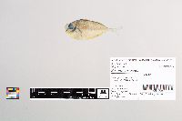 Secutor insidiator Bloch 48710[]Egan, Josh; Chew, Uik-Sen; Ghedotti, Michael 2016-05-07 Taiwan (Republic of China), Taiwan Strait, 22.661874 119.895642 |
JFBM:Fishes | 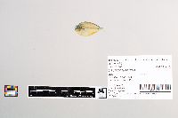 Secutor ruconius Hamilton 48711[]Egan, Josh; Chew, Uik-Sen; Ghedotti, Michael 2016-05-07 Taiwan (Republic of China), Taiwan Strait, 22.661874 119.895642 |
JFBM:Fishes | 49191[]Egan, Josh; Hundt, Peter; Kaeoprakan, Patcharee 2015-11-10 Thailand, Chonburi, Bang Sa-Re Beach, Sattahip district, 12.770403 100.897939 |
1
Page 1, records 1-6 of 6
Google Map
Google Maps is a web mapping service provided by Google that features a map that users can pan (by dragging the mouse) and zoom (by using the mouse wheel). Collection points are displayed as colored markers that when clicked on, displays the full information for that collection. When multiple species are queried (separated by semi-colons), different colored markers denote each individual species.