University of Minnesota
http://www.umn.edu/
612-625-5000
http://www.umn.edu/
612-625-5000
Minnesota Biodiversity Atlas
Bell Museum
Dataset: MIN-Bryophytes
Search Criteria: Canada; excluding cultivated/captive occurrences
Bell Museum bryophytes | |
 MIN:Bryophytes | 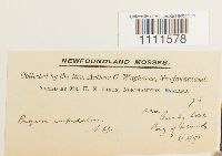 Bryum cuspidatum (Bruch & Schimp. in B.S.G.) Schimp. 30307[1111578]Waghorne, Arthur C. 781895-08-16 Canada, Newfoundland and Labrador, near Bucky Cove, Bay of Islands |
MIN:Bryophytes | 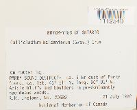 Callicladium haldanianum (Grev.) H.A. Crum 760498[1112540]Ireland, R.R. 206891982-07-21 Canada, Ontario, Parry Sound, ca. 5 km east of Parry Sound, 45.35 -80.03333 |
MIN:Bryophytes | 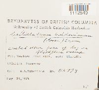 Callicladium haldanianum (Grev.) H.A. Crum 677525[1112549]Schofield, W.B. 557931974-05-29 Canada, British Columbia, Pitt Meadows dyke area, near Sharidan Wildlife Preserve, 49.227072 -122.667809 |
MIN:Bryophytes | 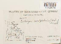 Calliergon cordifolium (Hedw.) Kindb. 397221[1112674]J. Marr M3771939-07-28 Canada, Quebec, East Coast of Hudson Bay, Cairn Island |
MIN:Bryophytes | 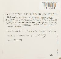 Calliergon cordifolium (Hedw.) Kindb. 677402[1112681]Schofield, W.B. 558171974-06-20 Canada, British Columbia, near Yakan Point, Graham I, Queen Charlotte, 54.070556 -131.835278 |
MIN:Bryophytes | 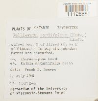 Calliergon cordifolium (Hedw.) Kindb. 747982[1112686]Frank D. Bowers 10812-b1981-07-12 Canada, Ontario, Alfred bog, S of Alfred (65 km E of Ottawa). |
MIN:Bryophytes | 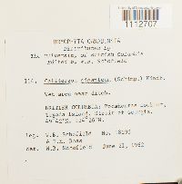 Calliergon giganteum (Schimp.) Kindb. 806066[1112707]Schofield, W.B. 182921962-06-21 Canada, British Columbia, Pocahontas Lookout, Texada Island, Strait of Georgia, 49.7 -124.43333 |
MIN:Bryophytes | 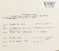 Calliergon giganteum (Schimp.) Kindb. 799493[1112708]C.E. Garton 211391982-07-26 Canada, Ontario, Thunder Bay, Teapot Lake, Shakespeare I, L. Nipigon., 49.616667 -88.383333 |
MIN:Bryophytes | 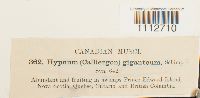 Calliergon giganteum (Schimp.) Kindb. 37351[1112710] 362 Canada, British Columbia, Prince Edward Island, Nova Scotia, Quebec, Ontario, and British Columbia |
MIN:Bryophytes | 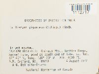 Calliergon giganteum (Schimp.) Kindb. 740566[1112717]Ireland, R.R. 189631977-08-04 Canada, British Columbia, CASSIAR DISTRICT: Omineca Mts, Kechika Range. Spinel Lake, pond at south end of lake, 57.81667 -126.38333, 1219m |
MIN:Bryophytes | 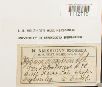 Calliergon giganteum (Schimp.) Kindb. 645565[1112719]M. Cardot s.n.1891-06-26 Canada, Newfoundland and Labrador |
MIN:Bryophytes | 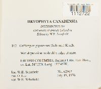 Calliergon giganteum (Schimp.) Kindb. 856477[1112722]Schofield, W.B. 629671976-07-19 Canada, British Columbia, Summit Lake, Hart Hwy., 54.2 -122.76667 |
MIN:Bryophytes | 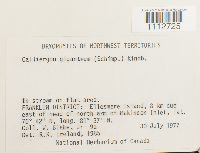 Calliergon giganteum (Schimp.) Kindb. 788402[1112725]Blake, Jr., W. 9a1977-07-30 Canada, Northwest Territories, FRANKLIN DISTRICT: Ellesmere Island, 8 km due east of head of north arm of Makinson Inlet, 76.7 -81.61667 |
MIN:Bryophytes | 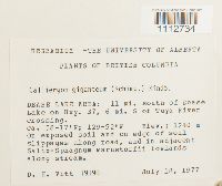 Calliergon giganteum (Schimp.) Kindb. 703171[1112734]D.H. Vitt 191901977-07-18 Canada, British Columbia, DEASE LAKE AREA: 11 mi. south of Dease. Lake on Hwy. 37, 6 mi. S of Tuya River crossing, 1240m |
MIN:Bryophytes | 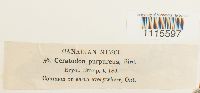 Ceratodon purpureus (Hedw.) Brid. 31460[1115597] 56 Canada, Ontario |
MIN:Bryophytes |  Cratoneuron filicinum (Hedw.) Spruce 793881[1116744]Guy R. Brassard 140041982-09-01 Canada, Newfoundland and Labrador, Division No. 9, Northern Peninsula, Ferolle Point, 51.016667 -57.1 |
MIN:Bryophytes | 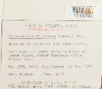 Cratoneuron filicinum (Hedw.) Spruce 547919[1116795]C.E.Garton 27541956-05-27 Canada, Ontario, Thunder Bay, Left bank of Kaministiquia River at Power Plant, below Kakabeka Falls, Oliver Twp. |
MIN:Bryophytes | 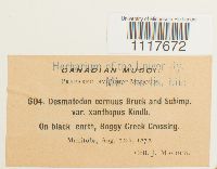 32024[1117672]J. Macoun 6041872-08-12 Canada, Manitoba, Boggy Creek Crossing |
MIN:Bryophytes | 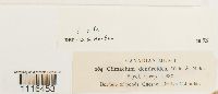 Climacium dendroides (Hedw.) F. Weber & D. Mohr 31729[1116453] 264 Canada, British Columbia, Quesnel |
MIN:Bryophytes | 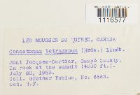 Conostomum tetragonum (Hedw.) Lindb. 502195[1116577]Brother Fabius 66631953-07-28 Canada, Quebec, Mont Jacques-Cartier, Gaspe County, 1280m |
MIN:Bryophytes | 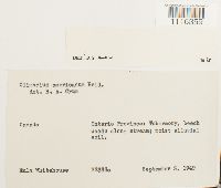 Climacium americanum Brid. 437699[1116359]Eula Whitehouse 22355a1949-09-03 Canada, Ontario, Tobermory |
MIN:Bryophytes | 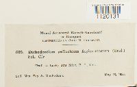 Dichodontium pellucidum var. fagimontanum (Brid.) Schimp. 32155[1120131]Fay A. MacFadden 6091926-05-13 Canada, British Columbia, Trail to Lucky Jim Mine |
MIN:Bryophytes | 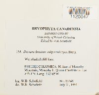 856481[1120647]Schofield, W.B. 253661964-07-31 Canada, British Columbia, Skeena-Queen Charlotte, N. face of Moresby Mountain, Moresby I, Queen Charlotte Is., 53.016667 -132.083333 |
MIN:Bryophytes | 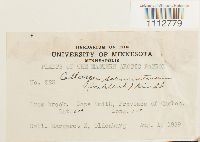 Calliergon sarmentosum (Wahlenb.) Kindb. 516266[1112779]Margaret E. Oldenburg 2231939-08-01 Canada, Quebec, Cape Smith, -61 -77 |
MIN:Bryophytes |  Dicranodontium longirostre (F. Weber & D. Mohr) Bruch & Schimp. 641879[1120691]John Macoun 39a1917-06-23 Canada, Ontario, Kettle Creek, Mt. Thomas |
MIN:Bryophytes | 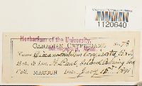 Dicranodontium denudatum (Brid.) E. Britton 32424[1120640]Macoun 781891-07-15 Canada, St. Paul Island, Bering Sea |
MIN:Bryophytes | 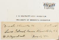 Dicranella heteromalla (Hedw.) Schimp. 668520[1120305]Osgood, W.H. s.n.1901-06-13 Canada, British Columbia, Luise Island, Queen Charlotte Gr. |
MIN:Bryophytes |  Cratoneuron filicinum (Hedw.) Spruce 793919[1116743]Guy R. Brassard 134871980-10-22 Canada, Newfoundland and Labrador, West Coast, ca. 4 km NE of Trout River, 49.51667 -58.1 |
MIN:Bryophytes |  Cratoneuron filicinum (Hedw.) Spruce 497075[1116792]Francis Harper 35981953-07-15 Canada, Newfoundland and Labrador, Attikamagen Lake, Northwest Bay, 54.983333 -66.683333, 471m |
MIN:Bryophytes |  Calliergon sarmentosum (Wahlenb.) Kindb. 375876[1112777] 14001936-09-08 Canada, Arctic Bay, Baffin Island |
MIN:Bryophytes |  Dichodontium pellucidum (Hedw.) Schimp. 641280[1120060]John Macoun 16a1898-08-18 Canada, Cape Buton Island |
MIN:Bryophytes |  Cratoneuron commutatum var. falcatum (Brid.) Mönk. 397496[1116731]Frye, T.C. 29281940-07-08 Canada, Alberta, Division No. 14, Jasper National Park, Miette Hot Springs, 53.266667 -117.65 |
MIN:Bryophytes | 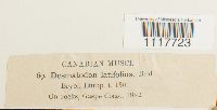 Desmatodon latifolius (Schultz) Ochyra 32026[1117723] 691882-00-00 Canada, Gaspe Coast |
MIN:Bryophytes |  Dicranella crispa (Hedw.) Schimp. 679817[1120253]Fay A. MacFadden 5871926-05-01 Canada, British Columbia, Carperter Creek bridge, Three Forks, 50.011611 -117.284395 |
MIN:Bryophytes | 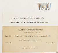 Dicranoweisia cirrata (Hedw.) Lindb. 641949[1120808]Hill, A.J. 5811902-04-00 Canada, British Columbia |
MIN:Bryophytes | 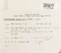 Cynodontium strumiferum (Hedw.) Lindb. 805961[1117394]C.E. Garton 209631982-06-23 Canada, Ontario, Thunder Bay, N. tip of Inner Barn I, Wabinosh Bay, Lake Nipigon. |
MIN:Bryophytes | 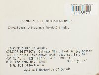 Conostomum tetragonum (Hedw.) Lindb. 740524[1116579]Ireland, R.R. s.n.1977-07-30 Canada, British Columbia, CASSIAR DISTRICT: Omineca Mts, Peak Range, beside, small glacial lake above Peak Lake, 57.66667 -126.75, 1128m |
MIN:Bryophytes | 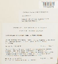 Calliergon trifarium (F. Weber & D. Mohr) Loeske 730975[1112815]Dale H. Vitt 257361980-08-01 Canada, British Columbia, MOUNT ROBSON PROVINCIAL PARK: Along Highway 5 south of Mt. George Graham, 3.3 mi. west of Grant Brook crossing. 52-55'N; 118-48'W, 1065m |
MIN:Bryophytes | 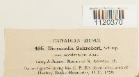 Dicranella schreberiana (Hedw.) Hilf. ex H.A. Crum & L.E. Anderson 32305[1120370] 4951890-00-00 Canada, British Columbia, along the C.P.R'y three miles west of Hector, Rocky Mountains |
MIN:Bryophytes | 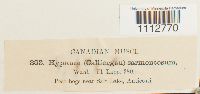 Calliergon sarmentosum (Wahlenb.) Kindb. 38108[1112770] 363 Canada, near Salt Lake, Anticosti |
MIN:Bryophytes | 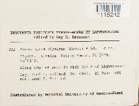 Catoscopium nigritum (Hedw.) Brid. 744246[1115242]Belland, Rene J. 41621981-06-21 Canada, Newfoundland and Labrador, Pointe Amour, 51.45 -56.86667 |
MIN:Bryophytes |  Cratoneuron commutatum (Brid.) G. Roth 703210[1116736]D.H. Vitt 232071978-08-13 Canada, Northwest Territories, Logan Mts, Lake close to South Nahanni River., 62.56667 -128.53333, 1560m |
MIN:Bryophytes | 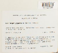 Calliergon giganteum (Schimp.) Kindb. 730946[1112739]Dale H. Vitt 258081980-08-03 Canada, Alberta, Division No. 15, JASPER NATIONAL PARK: Celestine Lake area. Along road, to Snake Indian Falls., 53.2 -118.116667, 1375m |
MIN:Bryophytes |  Cynodontium strumiferum (Hedw.) Lindb. 703599[1117406]Ireland, R.R. 151351971-08-11 Canada, Ontario, Algoma District, Algoma District: Kabenung Lake, 28 miles southeast of White River, 48.333333 -85 |
MIN:Bryophytes | 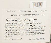 Campylium stellatum (Hedw.) C.E.O. Jensen 703199[1114513]D.H. Vitt 231811978-08-12 Canada, Northwest Territories, Fort Smith Region, LOGAN MOUNTAINS: Along SE shore of lake close to Nahanni River., 62.566667 -128.5, 1560m |
MIN:Bryophytes | 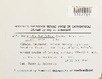 Desmatodon latifolius var. muticus (Brid.) Brid. 793886[1117711]Hedderson, Terry A. 18751983-07-19 Canada, Newfoundland and Labrador, Division No. 10, Torngat Mountains, Cirque Mountain Range, Cirque Camp, 58.95 -63.566667, 550 - 600m |
MIN:Bryophytes | 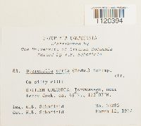 Dicranella varia (Hedw.) Schimp. 703360[1120394]Schofield, W.B. 332851967-04-12 Canada, British Columbia, Tsawwassen, near ferry dock. |
MIN:Bryophytes | 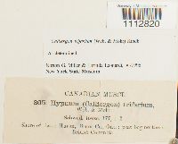 Calliergon trifarium (F. Weber & D. Mohr) Loeske 38423[1112820] 365 Canada, Ontario, Bruce, Shore of Lake Huron |
MIN:Bryophytes |  Calliergon stramineum (Dicks. ex Brid.) Kindb. 637025[1112794]J. Macoun 3451890-00-00 Canada, Ontario, in the area around OHana |
MIN:Bryophytes |  Calliergon stramineum (Dicks. ex Brid.) Kindb. 38380[1112793] 4731890-08-00 Canada, Anticosti Island (Quebec) and Roger's Pass, Selkirk Mountains (British Columbia) |
MIN:Bryophytes |  Campylophyllum halleri (Sw. ex Hedw.) M. Fleisch. 37414[1114727]Waghorne, Arthur C. 951897-07-07 Canada, Newfoundland and Labrador, Gabb's, Bay of Islands |
MIN:Bryophytes |  Cyrto-hypnum minutulum (Hedw.) W.R. Buck & H.A. Crum 788399[1117525]Ireland, R.R. 200781982-07-07 Canada, Ontario, Simcoe, 2 km southeast of Uptergrove, 44.6 -79.316667 |
MIN:Bryophytes |  Campylium chrysophyllum (Brid.) Lange 36717[1114397]Waghorne, A.C. 61899-05-07 Canada, Newfoundland and Labrador, Leading Tickles |
MIN:Bryophytes | 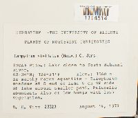 Campylium stellatum (Hedw.) C.E.O. Jensen 703238[1114514]D.H. Vitt 233231978-08-14 Canada, Yukon, Logan MTNS.: Lake close to South Nahanni River, 62.6 -128.5, 1560m |
MIN:Bryophytes | 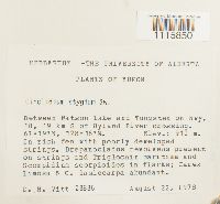 703264[1115850]D.H. Witt 238361978-08-22 Canada, Yukon, Yukon, Between Watson Lake and Tunsten on hwy 10, 19 km S of Hyland River crossing, 61.316667 -128.266667, 910m |
MIN:Bryophytes |  638679[1114646_1;1114646_2]George F. Atkinson 181896-08-21 Canada, Newfoundland and Labrador, Labrador |
MIN:Bryophytes |  Crumia latifolia (Kindb.) W.B. Schofield 703336[1117138]Schofield, W.B. 176611962-06-04 Canada, British Columbia, Capital, Willage Bay, Mayne I, S. Strait of Georgia, 48.833333 -123.25 |
MIN:Bryophytes | 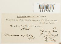 Desmatodon systylius (Schimp.) Lindb. 32067[1117801]Waghorne, Arthur C. 231896-06-20 Canada, Newfoundland and Labrador, Chimney Cove, Bay of Islands |
MIN:Bryophytes | 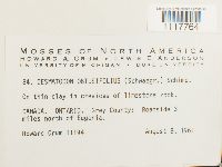 Desmatodon obtusifolius (Schwägr.) Mathieu 731235[1117764]Howard Crum 111941961-08-08 Canada, Ontario, Grey, Roadside 3 miles north of Eugenia, 44.3 -80.5 |
MIN:Bryophytes | 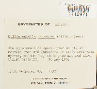 Calliergonella schreberi (Brid.) Grout 859432[1112971]C.M. Wetmore 11371958-05-30 Canada, Ontario, Algoma District: 1 mi south of Agawa River on Rt. 17 between road and lakeshore |
MIN:Bryophytes | 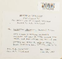 Campylium adscendens (Lindb.) Perss. in Perss. & Gjaer. 703358[1114348]Schofield, W.B. 338841967-06-24 Canada, British Columbia, Skeena-Queen Charlotte, W. side of Hippa I. Queen Charlotte Is., 53.533333 -132.983333 |
MIN:Bryophytes | 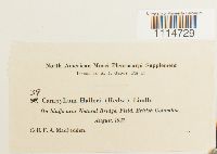 Campylophyllum halleri (Sw. ex Hedw.) M. Fleisch. 378392[1114729]F.A. MacFadden 391927-08-00 Canada, British Columbia, near Natural Bridge, Field |
MIN:Bryophytes | 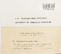 Claopodium bolanderi Best 641738[1116158]Fay. A. MacFadden 961927-04-14 Canada, British Columbia, Halcyon Hot Springs |
MIN:Bryophytes | 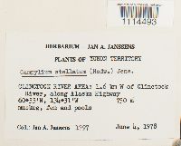 Campylium stellatum (Hedw.) C.E.O. Jensen 748722[1114493]Jan A. Janssens 17971978-06-04 Canada, Yukon, Clinctock River Area: 1.6 km W of Clinctock River, along Alaska Highway, 750m |
MIN:Bryophytes |  Climacium dendroides (Hedw.) F. Weber & D. Mohr 677595[1116461]Schofield, W.B. 575481974-11-12 Canada, British Columbia, E. end of Seabird Island, ca. 10 mi. N. of Agassiz, N. side of Fraser River |
MIN:Bryophytes | 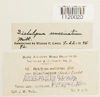 Dichelyma uncinatum Mitt. 32107[1120020]J.W. Bailey 921901-08-20 Canada, British Columbia, Comox Lake, 183m |
MIN:Bryophytes |  Calliergon giganteum (Schimp.) Kindb. 703506[1112737]Ireland, R.R. 179741978-08-11 Canada, Ontario, Carleton, Rideau Twp, Marlborough Ward, Klondyke Rd, 3 miles west of North Gower, 45.06667 -76.85 |
MIN:Bryophytes | 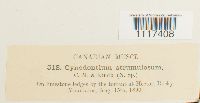 Cynodontium strumulosum Müll. Hal. & Kindb. 31987[1117408] 5181890-08-15 Canada, Alberta, by the torrent at Mount Hector, Rocky Mountains |
MIN:Bryophytes | 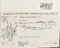 Campylium stellatum (Hedw.) C.E.O. Jensen 397220[1114494]J. Marr M4231939-08-26 Canada, Nunavut, East Coast of Hudson Bay, Belcher Islands |
MIN:Bryophytes |  Cratoneuron filicinum (Hedw.) Spruce 744330[1116771]Dale H. Vitt 265551981-06-19 Canada, Alberta, Kananaskis Area: Ribbon Creek and SE slope of Mt. Allen. Marmot Basin |
MIN:Bryophytes |  Cyrtomnium hymenophyllum (Bruch & Schimp.) Holmen 731361[1117550]Steere, William C. 100761948-07-02 Canada, Northwest Territories, Fort Smith Region, Edge of Dumpy Lake, north of Eldorado Mine, Port Radium, east end of McTavish Arm, Great Bear Lake, 66.083333 -118.033333 |
MIN:Bryophytes | 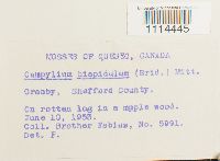 Campylium hispidulum (Brid.) Mitt. 502193[1114445]Fabius 59911953-06-10 Canada, Quebec, Shefford, 45.399096 -72.74492 |
MIN:Bryophytes | 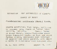 Chandonanthus setiformis (Ehrh.) Lindb. 703234[1115791]D.H. Vitt 229501978-08-10 Canada, Yukon, Inuvik Region, Selwyn Mountains: Itsi Range. North end of unnamed lake, South of Fuller Lake, 65.95 -130.15, 1600m |
MIN:Bryophytes |  Cratoneuron filicinum (Hedw.) Spruce 37222[1116760]Waghorne, Arthur C. 571896-06-15 Canada, Newfoundland and Labrador, Shaded Point, Bay of Islands |
MIN:Bryophytes | 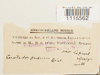 Ceratodon purpureus (Hedw.) Brid. 31467[1115562]Waghorne, A.C. 31894-10-30 Canada, Newfoundland and Labrador, near Toprail |
MIN:Bryophytes | 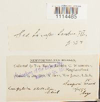 Campylium stellatum (Hedw.) C.E.O. Jensen 38332[1114485]Waghorne, Arthur C. 151893-11-30 Canada, Newfoundland and Labrador, Sampson's Island |
MIN:Bryophytes | 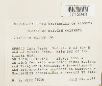 703275[1115848]Dale H. Vitt 196661977-07-24 Canada, British Columbia, Northern Rockies, SUMMIT LAKE AREA: 1.6 mi. W of the E end of Summit Lake. Mile 392 of the Alaska Hwy., 58.633333 -124.683333, 1350m |
MIN:Bryophytes | 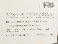 Calliergonella cuspidata (Hedw.) Loeske 731492[1112967]Schofield, Wilfred B. 109911959-09-10 Canada, Nova Scotia, Inverness, West Mabou Harbour, 46.07 -61.38 |
MIN:Bryophytes | 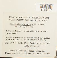 Ceratodon purpureus (Hedw.) Brid. 740543[1115497]Cody, W.J. 107141957-08-10 Canada, Northwest Territories, Mackenzie District: Eskimo lakes: West side of western most lake. Near Stanley Creek, 68.762441 -133.37763 |
MIN:Bryophytes | 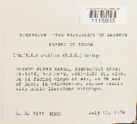 Cinclidium arcticum (Bruch & Schimp.) Schimp. 688765[1115833]D.H. Vitt 160941976-07-10 Canada, Yukon, Bonnet Plume Range, Pinguicula Lake, 853 - 975m |
MIN:Bryophytes | 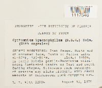 Cyrtomnium hymenophyllum (Bruch & Schimp.) Holmen 703201[1117546]Dale H Vitt 229841978-08-10 Canada, Yukon, Yukon, SELWYN MOUNTAINS: Itsi Range. North end of unnamed lake, South of Fuller Lake., 62.95 -130.15, 1600m |
MIN:Bryophytes | 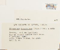 Climacium dendroides (Hedw.) F. Weber & D. Mohr 502194[1116470]Frére Fabius 13491947-07-05 Canada, Quebec, Shefford, 45.4 -72.733333 |
MIN:Bryophytes | 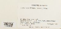 Cratoneuron filicinum (Hedw.) Spruce 703680[1116802]Ireland, R.R. 180061978-08-11 Canada, Ontario, Carleton, Rockcliffe Park, along Ottawa. River, just east of Ottawa. |
MIN:Bryophytes | 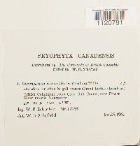 Dicranoweisia cirrata (Hedw.) Lindb. 677618[1120791]Schofield, W.B. 129581961-01-25 Canada, British Columbia, Greater Vancouver, Point Grey Golf Course, near Fraser river mouth, Vancouver, 49.333333 -123.25 |
MIN:Bryophytes | 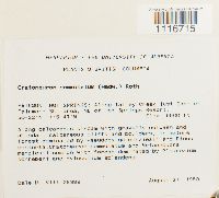 Cratoneuron commutatum (Brid.) G. Roth 730941[1116715]Dale H. Vitt 263891980-08-27 Canada, British Columbia, East Kootenay, Fairmont Hot Springs: Along Tatley Creek just East of Fairmont Ski area. NE of Hot Springs Resort, 50.366667 -115.783333, 1676m |
MIN:Bryophytes | 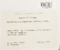 Catoscopium nigritum (Hedw.) Brid. 630657[1115261]D.H. Vitt 73571973-06-22 Canada, Alberta, EDSON AREA: 13.9 mi NNW of Marlboro., 16.983333 -53.666667 |
MIN:Bryophytes | 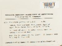 Dichelyma pallescens Bruch & Schimp. 744244[1117997]Guy R. Brassard 134571980-10-21 Canada, Newfoundland and Labrador, Division No. 9, Newfoundland: West coast, head of Upper Trout River Pond, 49.366667 -57.966667 |
MIN:Bryophytes | 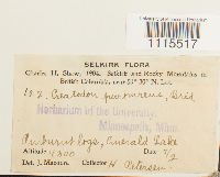 Ceratodon purpureus (Hedw.) Brid. 31457[1115517]H. Peterson 122 Canada, British Columbia, Selkirk and Rocky Mountains: Yoho National Park: Emerald Lake |
MIN:Bryophytes |  Campylium chrysophyllum (Brid.) Lange 36709[1114357] 329 Canada, throughout Canada |
MIN:Bryophytes |  Cirriphyllum piliferum (Hedw.) Grout 733451[1116063]Belland, Rene J. 28461980-06-03 Canada, Newfoundland and Labrador, Newfoundland: West coast, Bonne Bay region, near turnoff to Lomond,, 49.4 -57.8 |
MIN:Bryophytes |  Calliergon sarmentosum (Wahlenb.) Kindb. 703269[1112782]D.H. Vitt 195111977-07-21 Canada, British Columbia, Cassiar Mtns. Stikine Rng.: Lake at headwaters of S-flowing stream, SE of Simpson Peak. Along cr from central-W shore of lake and in cirque valley above, 59.666667 -131.3, 1250 - 1500m |
MIN:Bryophytes |  Dichodontium pellucidum var. serratum (Bruch & Schimp.) Schimp. 641296[1120095]F.A. MacFadden 1101927-05-11 Canada, British Columbia, Four Mile Creek, Silverton |
MIN:Bryophytes | 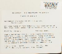 Calliergon richardsonii (Mitt.) Kindb. 744276[1112753]Dale H. Vitt 300571982-05-22 Canada, Alberta, Division No. 16, 50 mi. N of Fort McMurray: SW corner of McClelland Lake, about 7 mi. NE of Fort Hills, 57.45 -111.433333, 299m |
MIN:Bryophytes | 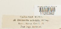 Dicranella subulata (Hedw.) Schimp. 32334[1120382] 28 Canada, Anticosti |
MIN:Bryophytes | 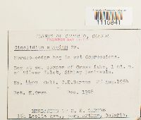 547915[1115841]C.E. Garton 44091956-08-25 Canada, Ontario, SW corner of Grass Lake, 1 mi. N of Silver Islet, Sibley Peninsula., 48.343333 -88.810278 |
MIN:Bryophytes | 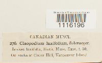 Claopodium laxifolium (Hook.) Renauld & Cardot 31696[1116196] 276 Canada, British Columbia, Vancouver Island, Cedar Hill |
MIN:Bryophytes | 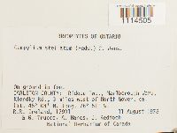 Campylium stellatum (Hedw.) C.E.O. Jensen 703525[1114505]Ireland, R.R. 179911978-08-11 Canada, Ontario, Carleton, Rideau Twp, Marlborough Ward, Klondky Rd, 3 miles west of North Gower, 45.066667 -76.85 |
MIN:Bryophytes | 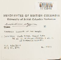 677415[1115846]Schofield, W.B. 562751974-07-17 Canada, British Columbia, Windy Point, McLeod Lake, 96 mi. n. of Prince George, 1 mi. s. of MacKenzie turnoff., 55.116184 -122.986654 |
MIN:Bryophytes | 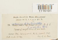 Claopodium crispifolium (Hook.) Renauld & Cardot 31693[1116191]J.W. Bailey 701901-06-17 Canada, British Columbia, Comox Bay, Vancouver Id. |
MIN:Bryophytes | 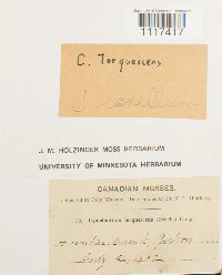 Cynodontium tenellum (Schimp.) Limpr. 641172[1117417]John Macoun 191902-00-00 Canada, Hunker Creek, Zulton |
Google Map
Google Maps is a web mapping service provided by Google that features a map that users can pan (by dragging the mouse) and zoom (by using the mouse wheel). Collection points are displayed as colored markers that when clicked on, displays the full information for that collection. When multiple species are queried (separated by semi-colons), different colored markers denote each individual species.