University of Minnesota
http://www.umn.edu/
612-625-5000
http://www.umn.edu/
612-625-5000
Minnesota Biodiversity Atlas
Bell Museum
Dataset: MIN-Bryophytes
Search Criteria: Antarctica; excluding cultivated/captive occurrences
Bell Museum bryophytes | |
 MIN:Bryophytes | 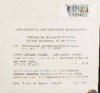 Andreaea depressinervis Cardot 756819[1098463]Ochyra, R. 1385/801980-02-02 Antarctica, South Shetland Islands - King George Islands: Admiralty Bay, Demay Point at entrance to bay on the west coast., -62.21667 -58.41667, 60m |
MIN:Bryophytes | 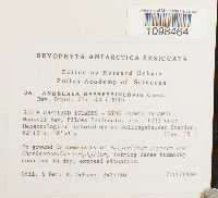 Andreaea depressinervis Cardot 756844[1098464]Ochyra, R. 2427/801908-03-01 Antarctica, SOUTH SHETLAND ISLANDS - KING GEORGE ISLAND: Maxwell Bay, Fildes Peninsula, small hill near Meteorological Laboratory at Bellingshausen Station, -62.2 -58.96667, 15m |
MIN:Bryophytes | 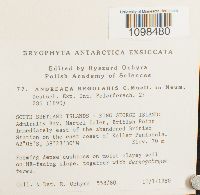 Andreaea regularis Müll. Hal. 756793[1098480]Ochyra, Ryszard 558/801980-01-10 Antarctica, SOUTH SHETLAND ISLANDS - KING GEORGE ISLAND: Admiralty Bay, Martel Inlet, British Point immediately east of the abandoned British Station on the east coast of Keller Peninsula, -62.08333 -58.39167, 70m |
MIN:Bryophytes | 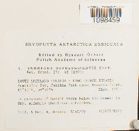 Andreaea depressinervis Cardot 756669[1098459]Ochyra, R. 5149/791979-12-30 Antarctica, SOUTH SHETLAND ISLANDS - KING GEORGE ISLAND: Admiralty Bay, Jardine Peak above Ezcurra Inlet, -62.16667 -58.5, 275m |
MIN:Bryophytes | 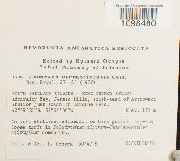 Andreaea depressinervis Cardot 756694[1098460]Ochyra, R. 5074/791979-12-27 Antarctica, SOUTH SHETLAND ISLANDS - KING GEORGE ISLAND: Admiralty Bay, Jersak Hills, south-west of Arctowski Station just south of Jardine Peak., -62.15833 -58.49167, 170m |
MIN:Bryophytes | 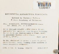 Andreaea depressinervis Cardot 756719[1098461]Ochyra, R. 4928/791979-12-23 Antarctica, SOUTH SHETLAND ISLANDS - KING GEORGE ISLAND: Admiralty Bay, mountain slope between Petrified Forest Creek and Ornithologist's Creek, south of Arctowski Station called Ubocz., -62.166667 -58.483333, 110m |
MIN:Bryophytes | 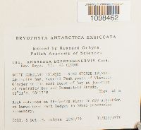 Andreaea depressinervis Cardot 756769[1098462]Ochyra, R. 5260/791979-12-31 Antarctica, SOUTH SHETLAND ISLANDS - KING GEORGE ISLAND: Admiralty Bay, Vaureal Peak south of Vieville Glacier on the east coast of bay at junction of Admiralty Bay and Bransfield Strait., -62.18333 -58.28333, 40m |
MIN:Bryophytes | 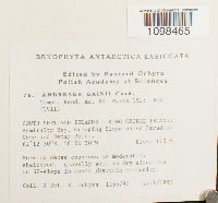 Andreaea gainii Cardot 756794[1098465]Ochyra, R. 1265/801980-01-27 Antarctica, SOUTH SHETLAND ISLANDS - KING GEORGE ISLAND: Admiralty Bay, Creeping Slope above Paradise Cove and Demay Point., -62.20833 -58.44167, 115m |
MIN:Bryophytes | 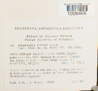 Andreaea gainii Cardot 756818[1098466]Ochyra, R. 35/801980-01-01 Antarctica, SOUTH SHETLAND ISLANDS - KING GEORGE ISLAND: Admiralty Bay, hill between Baranowski Glacier and Sphinx Glacier called Zamek (=castle)., -62.19167 -58.48333 |
MIN:Bryophytes | 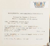 Andreaea gainii Cardot 756718[1098467]Ochyra, R. 2205/801980-02-18 Antarctica, SOUTH SHETLAND ISLANDS - KING GEORGE Admiralty Bay, Basalt Point at Spera north end of Vieville Glacier., -62.12778 -58.38333, 20m |
MIN:Bryophytes | 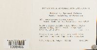 Andreaea gainii Cardot 756843[1098468]Ochyra, R. 597/801980-01-11 Antarctica, SOUTH SHETLAND ISLANDS - KING GEORGE ISLAND: Admiralty Bay, Martel Inlet, Ullman Spur., -62.066667 -58.35, 80m |
MIN:Bryophytes | 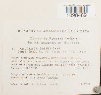 Andreaea gainii Cardot 756868[1098469]Ochyra, R. 777/801980-01-18 Antarctica, SOUTH SHETLAND ISLANDS - KING GEORGE ISLAND: Admiralty Bay, nunatak in the middle of the lower part of Baranowski Glacier called Siodlo (=saddle). 62°12fS, 58°27'W, -62.2 -58.45, 110m |
MIN:Bryophytes | 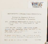 Andreaea regularis Müll. Hal. 756693[1098475]Ochyra, R. 505/801980-01-10 Antarctica, SOUTH SHETLAND ISLANDS - KING GEORGE ISLAND: Admiralty Bay, MacKellar Inlet, Ore Point at the west coast of Keller Peninsula., -62.07222 -58.425, 3m |
MIN:Bryophytes | 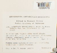 Andreaea regularis Müll. Hal. 756716[1098476]Ochyra, R. 5093/791979-12-28 Antarctica, SOUTH SHETLAND ISLANDS - KING GEORGE ISLAND: Admiralty Bay, Jersak Hills south-west of Arctowski Station, immediately south of Jardine Peak, -62.15833 -58.49167, 210m |
MIN:Bryophytes | 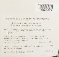 Andreaea regularis Müll. Hal. 756717[1098477]Ochyra, R. 477/801980-01-10 Antarctica, SOUTH SHETLAND ISLANDS - KING GEORGE ISLAND: Bransfield Strait, Red Hill, between Polar Club Glacier and Windy Glacier., -62.23333 -58.5, 100m |
MIN:Bryophytes | 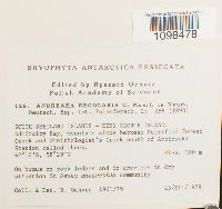 Andreaea regularis Müll. Hal. 756744[1098478]Ochyra, R. 4961/791979-12-23 Antarctica, SOUTH SHETLAND ISLANDS - KING GEORGE ISLAND: Admiralty Bay, mountain slope between Petrified Forest Creek and Ornithologist's Creek south of Arctowski Station called Ubocz., 100m |
MIN:Bryophytes | 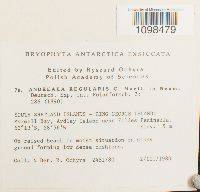 Andreaea regularis Müll. Hal. 756792[1098479]Ochyra, R. 2481/801980-03-02 Antarctica, SOUTH SHETLAND ISLANDS - KING GEORGE ISLAND: Maxwell Bay, Ardley Island near Fildes Peninsula, -62.21667 -58.93333, 5m |
MIN:Bryophytes | 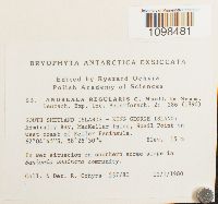 Andreaea regularis Müll. Hal. 756817[1098481]Ochyra, R. 537/801980-01-10 Antarctica, SOUTH SHETLAND ISLANDS - KING GEORGE ISLAND: Admiralty Bay, MacKellar Inlet, Speil Point on west coast of Keller Peninsula., -62.07917 -58.425, 15m |
MIN:Bryophytes | 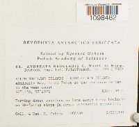 Andreaea regularis Müll. Hal. 756842[1098482]Ochyra, R. 1386/801980-02-02 Antarctica, SOUTH SHETLAND ISLANDS - KING GEORGE ISLAND: Admiralty Bay, Demay Point at the entrance to bay on the west coast., -62.216667 -58.416667, 50m |
MIN:Bryophytes | 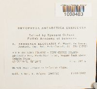 Andreaea regularis Müll. Hal. 756867[1098483]Ochyra, R. 2007/801908-02-15 Antarctica, SOUTH SHETLAND ISLANDS - KING GEORGE ISLAND: Admiralty Bay, MacKellar Inlet, Wegger Peak above Crepin Point., -62.091667 -58.333333, 295m |
MIN:Bryophytes | 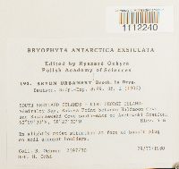 Bryum urbanskyi Broth. 756677[1112240]Ochyra, R. 2397/801980-02-29 Antarctica, SOUTH SHETLAND ISLANDS - KING GEORGE ISLAND: Admiralty Bay, Rakusa Point between Halfmoon Cove and Suszczewski Cove south-east of Arctowski Station., 62.158333 -58.458333, 4m |
MIN:Bryophytes | 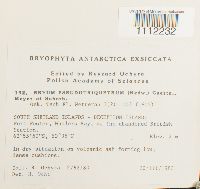 Bryum pseudotriquetrum (Hedw.) P. Gaertn., B. Mey. & Scherb. 756678[1112232]Ochyra, R. 2762/801980-03-20 Antarctica, SOUTH SHETLAND ISLANDS - DECEPTION ISLAND: Port Foster, Whalers Bay, at the abandoned British Station., -62.930556 -60.583333, 2m |
MIN:Bryophytes |  Bryum pseudotriquetrum (Hedw.) P. Gaertn., B. Mey. & Scherb. 756755[1112235]Ochyra, R. 1151980-03-02 Antarctica, SOUTH SHETLAND ISLANDS; KING GEORGE ISLAND; Maxwell Bay; Fildes Peninsula; Lake Kitezh at Bellingshausen Station., -62.2 -58.966667, 15m |
MIN:Bryophytes | 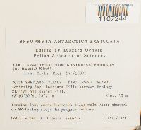 Brachythecium austrosalebrosum (Müll. Hal.) Paris 756671[1107244]Ochyra, R. 4916/791979-12-22 Antarctica, SOUTH SHETLAND ISLANDS - KING GEORGE ISLAND: Admiralty Bay, Rescuers Hills between Ecology Glacier and Sphinx Hill., -62.175 -58.45, 15m |
MIN:Bryophytes | 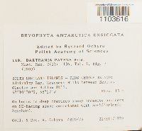 Bartramia patens Brid. 756752[1103616]Ochyra, R. 4890/791979-12-22 Antarctica, SOUTH SHETLAND ISLANDS - KING GEORGE ISLAND: Admiralty Bay, Rescuers Hills between Ecology Glacier and Sphinx Hill., -62.175 -58.45, 15m |
MIN:Bryophytes | 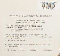 Brachythecium subpilosum (Hook. f. & Wilson) A. Jaeger 756798[1107255]Ochyra, R. 1725/801980-02-06 Antarctica, SOUTH SHETLAND ISLANDS - KING GEORGE ISLAND: Admiralty Bay, at NE foot of Panorama Ridge, of Point Thomas., -62.14167 -58.49167, 4m |
MIN:Bryophytes | 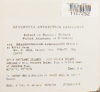 Brachythecium subpilosum (Hook. f. & Wilson) A. Jaeger 756696[1107252]Ochyra, R. 5078/791979-12-27 Antarctica, SOUTH SHETLAND ISLANDS - KING GEORGE ISLAND: Admiralty Bay, Ezcurra Inlet, Italia Valley west of Jardine Peak., -62.5 -58.51667, 8m |
MIN:Bryophytes | 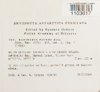 Bartramia patens Brid. 756703[1103617]Ochyra, R. 601/801980-01-11 Antarctica, SOUTH SHETLAND ISLANDS - KING GEORGE ISLAND: Admiralty Bay, Martel Inlet, Ullman Spur., -62.083333 -58.35, 100m |
MIN:Bryophytes | 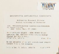 Brachythecium austrosalebrosum (Müll. Hal.) Paris 756697[1107245]Ochyra, R. 4881/791979-12-21 Antarctica, SOUTH SHETLAND ISLANDS - KING GEORGE ISLAND: Admiralty Bay, Rescuers Hills between Ecology Glacier and Sphinx Hill., 10.5 -58.45, 35m |
MIN:Bryophytes |  Bryum pseudotriquetrum (Hedw.) P. Gaertn., B. Mey. & Scherb. 756729[1112234]Ochyra, R. 2631/801980-03-09 Antarctica, South Shetland, King George Island: Admiralty Bay, Llano Point south of Suszczewski Cove., -62.170833 -58.441667, 4m |
MIN:Bryophytes |  Bryum pseudotriquetrum (Hedw.) P. Gaertn., B. Mey. & Scherb. 756704[1112233]Ochyra, R. 4889/791979-12-22 Antarctica, SOUTH SHETLAND ISLANDS - KING GEORGE ISLAND: Admiralty Bay, Rescuers Hills between Ecology Glacier and Sphinx Hill., -62.175 -58.45, 15m |
MIN:Bryophytes | 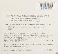 Brachythecium subpilosum (Hook. f. & Wilson) A. Jaeger 756725[1107253]Ochyra, R. 636/801980-01-14 Antarctica, SOUTH SHETLAND ISLANDS - KING GEORGE ISLAND: Admiralty Bay, at E foot of Skua Cliff at confluence of Petrified Forest Creek and Geographer's Creek, west of Arctowski Station., -62.15833 -58.5625, 30m |
MIN:Bryophytes | 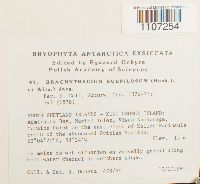 Brachythecium subpilosum (Hook. f. & Wilson) A. Jaeger 756773[1107254]Ochyra, R. 478/801980-01-10 Antarctica, East Berbice-Corentyne, SOUTH SHETLAND ISLANDS - KING GEORGE ISLAND: Admiralty Bay, Martel Inlet, Visca Anchorage, Moraine Point on the east coast of Keller Peninsula north of the abandoned British Station., 4.333333 -58.4, 15m |
MIN:Bryophytes | 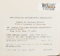 Brachythecium austrosalebrosum (Müll. Hal.) Paris 756774[1107248]Ochyra, R. 644/801980-01-15 Antarctica, SOUTH SHETLAND ISLANDS - KING GEORGE ISLAND: Admiralty Bay, small stream west of Jersak Hills, south-west of Arctowski Station., -62.15833 -58.49167, 120m |
MIN:Bryophytes |  Bartramia patens Brid. 756856[1103614]Ochyra, R. 2049/801980-02-15 Antarctica, SOUTH SHETLAND ISLANDS - KING GEORGE ISLAND: Admiralty Bay, MacKellar Inlet, Crepin Point., -62.083333 -58.466667, 15m |
MIN:Bryophytes | 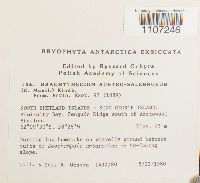 Brachythecium austrosalebrosum (Müll. Hal.) Paris 756726[1107246]Ochyra, R. 1432/801980-02-05 Antarctica, SOUTH SHETLAND ISLANDS - KING GEORGE ISLAND: Admiralty Bay, Penguin Ridge south of Arctowski Station., 9.5 -58.466667, 45m |
MIN:Bryophytes |  Bryum dichotomum Hedw. 756754[1112230]Ochyra, R. 882/801980-01-19 Antarctica, SOUTH SHETLAND ISLANDS - KING GEORGE ISLAND: Admiralty Bay, Ezcurra Inlet, Cardozo Cove, Pond Hill. 62°10*S, 58°36fW, -62.166667 -58.6, 70m |
MIN:Bryophytes | 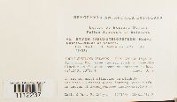 Bryum pseudotriquetrum (Hedw.) P. Gaertn., B. Mey. & Scherb. 756778[1112237]Ochyra, R. 5253/791979-12-31 Antarctica, SOUTH SHETLAND ISLANDS -KING GEORGE ISLAND: Admiralty Bay, Cape Vaureal south of Vieville Glacier on the east coast at entrance to bay. 62°11,S, 58°17'W, -62.183333 -58.283333, 35m |
MIN:Bryophytes | 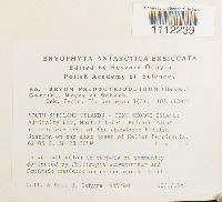 Bryum pseudotriquetrum (Hedw.) P. Gaertn., B. Mey. & Scherb. 756804[1112239]Ochyra, R. 459/801980-01-10 Antarctica, SOUTH SHETLAND ISLANDS - KING GEORGE ISLAND: Admiralty Bay, Martel Inlet, British Point immediately east of the abandoned British Station on the east coast of Keller Penninsula, -62.08333 -58.39167, 3m |
MIN:Bryophytes | 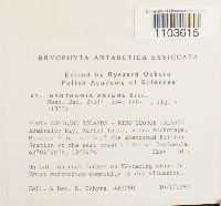 Bartramia patens Brid. 756803[1103615]Ochyra, R. 487/801980-01-10 Antarctica, SOUTH SHETLAND ISLANDS - KING GEORGE ISLAND: Admiralty Bay, Martel Inlet, Visca Anchorage, Moraine Point north of the abandoned British Station on the east coast of Keller Peninsula., -62.072222 -58.4, 30m |
MIN:Bryophytes | 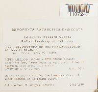 Brachythecium austrosalebrosum (Müll. Hal.) Paris 756748[1107247]Ochyra, R. 1382/801980-02-02 Antarctica, SOUTH SHETLAND ISLANDS - KING GEORGE ISLAND: Admiralty Bay, Demay Point on west coast of bay at junction with Bransfield Strait., -62.208333 -58.441667, 40m |
MIN:Bryophytes |  Brachythecium austrosalebrosum (Müll. Hal.) Paris 756799[1107249]Ochyra, R. 1053/801980-01-24 Antarctica, SOUTH SHETLAND ISLANDS, KING GEORGE ISLAND: Admiralty Bay, Uchatka. Point south of Paradise Cove and Demay Point on the west coast of bay, -62.220833 -58.416667, 25m |
MIN:Bryophytes |  Brachythecium austrosalebrosum (Müll. Hal.) Paris 756850[1107251]Ochyra, R. 5256/791979-12-31 Antarctica, SOUTH SHETLAND ISLANDS - KING GEORGE ISLAND: Admiralty Bay, Cape Vaureal south of Vieville Glacier at the entrance to the bay., -62.183333 -58.283333, 35m |
MIN:Bryophytes |  Bryum argenteum Hedw. 756829[1112229]Ochyra, R. 972/801980-01-20 Antarctica, SOUTH SHETLAND ISLANDS - KING GEORGE ISLAND: Admiralty Bay, Ezcurra Inlet, Golden Cove, mountain ridge called Cytadela, moraine below Gdansk Icefall., -62.183333 -58.583333, 10m |
MIN:Bryophytes | 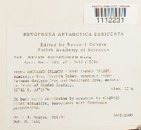 Bryum dichotomum Hedw. 756705[1112231]Ochyra, R. 958/801980-01-20 Antarctica, SOUTH SHETLAND ISLANDS - KING GEORGE ISLAND: Admiralty Bay, Ezcurra Inlet, mountain ridge between Goulden Cove and Monsiment Cove. in front of Gdansk Icefall., -62.18333 -58.58333, 10m |
MIN:Bryophytes |  Bryum pseudotriquetrum (Hedw.) P. Gaertn., B. Mey. & Scherb. 756779[1112236]Ochyra, R. 364/801980-01-08 Antarctica, SOUTH SHETLAND ISLANDS - KING GEORGE ISLAND: Admiralty Bay, Agat Point, south of Sphinx Hill, -62.19167 -58.43333, 12m |
MIN:Bryophytes |  Bryum pseudotriquetrum (Hedw.) P. Gaertn., B. Mey. & Scherb. 756805[1112238]Ochyra, R. 2631/801980-03-09 Antarctica, SOUTH SHETLAND ISLANDS - KING GEORGE ISLAND: Admiralty Bay, Biaszyk Moraine south of Sphinx Hill separating Baranowski Glacier and Sphinx Glacier., -62.183333 -58.45, 5m |
MIN:Bryophytes | 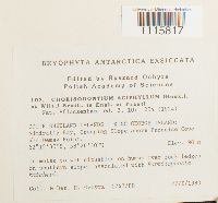 Chorisodontium aciphyllum (Hook. f. & Wilson) Broth. 756763[1115817]Ochyra, R. 1247/801980-01-27 Antarctica, SOUTH SHETLAND ISLANDS - KING GEORGE ISLAND: Admiralty Bay, Creeping Slope above Paradise Cove and Demay Point., -62.208333 -58.441667, 90m |
MIN:Bryophytes | 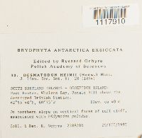 Desmatodon heimii (Hedw.) R.H. Zander 756838[1117910]Ochyra, R. 2788/801980-03-20 Antarctica, SOUTH SHETLAND ISLANDS - DECEPTION ISLAND: Port Foster, Whalers Bay, Ronald Hill above the destroyed British Station., 55.666667 -60.583333, 40m |
MIN:Bryophytes | 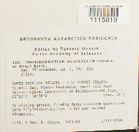 Chorisodontium aciphyllum (Hook. f. & Wilson) Broth. 756710[1115819]Ochyra, R. 2401/801980-03-01 Antarctica, SOUTH SHETLAND ISLANDS - KING GEORGE ISLAND: Maxwell Bay, Fildes Peninsula, small hill near Meteorological Laboratory at Bellingshausen Station, -62.2 -58.96667, 15m |
MIN:Bryophytes | 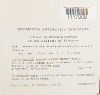 Desmatodon austrogeorgicus (Cardot) Ochyra 756761[1117908]Ochyra, R. 5139/791979-12-29 Antarctica, SOUTH SHETLAND ISLANDS - KING GEORGE ISLAND: Admiralty Bay. Jersak Hills south-west of Arctowski Station, south of Jardine Peak., -62.158333 -58.491667, 175m |
MIN:Bryophytes | 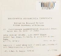 Calliergon sarmentosum (Wahlenb.) Kindb. 756853[1112927]Ochyra, R. 2479/801980-03-02 Antarctica, South Shetland Islands--King George Island: Maxwell Bay, Fildes Peninsula, at north foot of Gemmel Peaks, -62.216667 -58.983333, 15m |
MIN:Bryophytes | 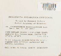 Conostomum magellanicum Sull. 756855[1116613]Ochyra, R. 5196/791979-12-30 Antarctica, SOUTH SHETLAND ISLANDS - KING GEORGE ISLAND: Admiralty Bay, Ezcurra Inlet, Jardine Peak, -62.16667 -58.5, 275m |
MIN:Bryophytes | 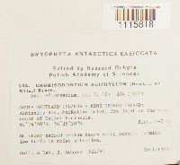 Chorisodontium aciphyllum (Hook. f. & Wilson) Broth. 756738[1115818]Ochyra, R. 521/801980-01-10 Antarctica, SOUTH SHETLAND ISLANDS - KING GEORGE ISLAND: Admiralty Bay, MacKellar Inlet, Ore Point on the west coast of Keller Peninsula., -62.072222 -58.425, 4 - 5m |
MIN:Bryophytes | 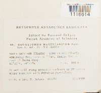 Conostomum magellanicum Sull. 756802[1116614]Ochyra, R. 114/801980-01-03 Antarctica, SOUTH SHETLAND ISLANDS - KING GEORGE ISLAND: Admiralty Bay, Ezcurra Inlet, Italia Valley east of Herve Cove., -62.5 -58.516667, 100m |
MIN:Bryophytes | 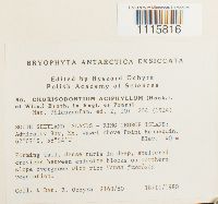 Chorisodontium aciphyllum (Hook. f. & Wilson) Broth. 756790[1115816]Ochyra, R. 2163/801980-02-18 Antarctica, SOUTH SHETLAND ISLANDS - KING GEORGE ISLAND: Admiralty Bay, Mt. Wawel above Point Hennequin., -62.116667 -58.4, 40m |
MIN:Bryophytes | 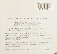 Desmatodon heimii (Hedw.) R.H. Zander 756736[1117911]Ochyra, R. 2761/801980-03-16 Antarctica, SOUTH SHETLAND ISLANDS - KING GEORGE ISLAND: Admiralty Bay, Rembiszewski Nunataks between Vieville Glacier and Rybak Glacier., -62.15833 -58.3, 190m |
MIN:Bryophytes | 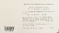 Calliergon sarmentosum (Wahlenb.) Kindb. 756777[1112926]Ochyra, R. 1492/801980-02-05 Antarctica, SOUTH SHETLAND ISLANDS - KING GEORGE ISLAND: Admiralty Bay, wet meadow immediately south of Arctowski Station called Jasnorzewski Gardens, -62.15 -58.466667, 4m |
MIN:Bryophytes | 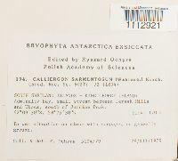 Calliergon sarmentosum (Wahlenb.) Kindb. 756676[1112921]Ochyra, R. 5104/791979-12-28 Antarctica, SOUTH SHETLAND ISLANDS - KING GEORGE ISLAND: Admiralty Bay, small stream between Jersak Hills and Ubocz, south of Jardine Peak, 62.158333 -58.491667, 170m |
MIN:Bryophytes |  Desmatodon austrogeorgicus (Cardot) Ochyra 756813[1117909]Ochyra, R. 942/801980-01-20 Antarctica, SOUTH SHETLAND ISLANDS - KING GEORGE ISLAND: Admiralty Bay, Ezcurra Inlet, mountain ridge called Cytadela between Monsimet Cove and Golden Cove., -62.183333 -58.583333, 5 - 10m |
MIN:Bryophytes |  756691[1115722]Ochyra, R. 2763/801980-03-20 Antarctica, SOUTH SHETLAND ISLANDS - DECEPTION ISLAND: Port Foster, Whalers Bay, at the abandoned British Station., -62.930556 -60.583333, 2m |
MIN:Bryophytes | 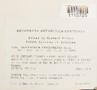 756740[1115725]Ochyra, R. 5244/791979-12-31 Antarctica, SOUTH SHETLAND ISLANDS - KING GEORGE ISLAND: Admiralty Bay, Cape Vaureal south of Vieville Glacier on the east coast of bay at junction with Bransfield Strait., -62.183333 -58.283333, 35m |
MIN:Bryophytes | 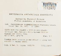 Calliergon sarmentosum (Wahlenb.) Kindb. 756702[1112922]Ochyra, R. 4918/791979-12-22 Antarctica, SOUTH SHETLAND ISLANDS - KING GEORGE ISLAND: Admiralty Bay, Rescuers Hills between Ecology Glacier and Sphinx Hill., -62.175 -58.4, 3m |
MIN:Bryophytes | 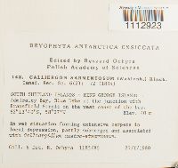 Calliergon sarmentosum (Wahlenb.) Kindb. 756728[1112923]Ochyra, R. 1185/801980-01-27 Antarctica, SOUTH SHETLAND ISLANDS - KING GEORGE ISLAND: Admiralty Bay, Blue Dyke at the junction with Bransfield Strait on the west coast of the bay., 13.666667 -58.45, 40m |
MIN:Bryophytes | 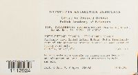 Calliergon sarmentosum (Wahlenb.) Kindb. 756751[1112924]Ochvra, R. 456/801980-01-10 Antarctica, SOUTH SHETLAND ISLANDS - KING GEORGE ISLAND: Admiralty Bay, Martel Inlet, British Point immediately east of the abandoned British Station on east coast of Keller Peninsula., -62.083333 -58.383333, 3m |
MIN:Bryophytes | 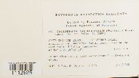 Calliergon sarmentosum (Wahlenb.) Kindb. 756827[1112925]Ochyra, R. 527/801980-01-10 Antarctica, SOUTH SHETLAND ISLANDS - KING GEORGE ISLAND: Admiralty Bay, MacKellar Inlet, Speil Point on the west coast of Keller Peninsula., -62.079167 -58.425, 6m |
MIN:Bryophytes | 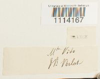 31064[1114167]Verlot, J. B. s.n. Antarctica, Mount Vito |
MIN:Bryophytes | 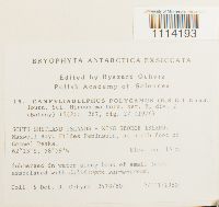 Campyliadelphus polygamus (Schimp.) Kanda 756852[1114193]Ochyra, R. 2478/801980-03-02 Antarctica, SOUTH SHETLAND ISLANDS - KING GEORGE ISLAND: Maxwell Bay, Fildes Peninsula, at north foot of Gemmel Peaks, -62.216667 -58.983333, 15m |
MIN:Bryophytes | 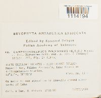 Campyliadelphus polygamus (Schimp.) Kanda 756828[1114194]Ochyra, R. 2458/801980-03-02 Antarctica, SOUTH SHETLAND ISLANDS - KING GEORGE ISLAND: Maxwell Bay, Fildes Peninsula, Lake Kitezh at Bellingshausen Station., -62.2 -58.966667, 15m |
MIN:Bryophytes | 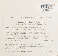 756690[1115721]Ochyra, R. 966/801980-01-20 Antarctica, South Shetland Islands-King George Island: Admiralty Bay, Ezcurra Inlet, mountain ridge called Cytadela between Goulden Cove and Monsimet Cove, moraine in front of Gdansk Icefall, -62.183333 -58.583333, 10m |
MIN:Bryophytes | 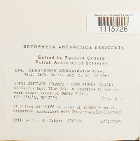 756766[1115726]Ochyra, R. 1205/801980-01-27 Antarctica, South Shetland Islands- King George Island: Admiralty Bay, Blue Dyke at the Entrance to bay on west coast south of Demay Point, -62.227778 -58.45, 4m |
MIN:Bryophytes | 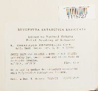 756862[1115727]Ochyra, R. 5226/791979-12-12 Antarctica, SOUTH SHETLAND ISLANDS - KING GEORGE ISLAND: Admiralty Bay, small green alp called Hala at Arctowski Station., -62.15 -58.48333, 15m |
MIN:Bryophytes | 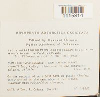 Chorisodontium aciphyllum (Hook. f. & Wilson) Broth. 756860[1115814]Ochyra, R. 2493/801980-03-02 Antarctica, SOUTH SHETLAND ISLANDS - KING GEORGE ISLAND: Maxwell Bay, Ardley Island near Fildes Peninsula., -62.216667 -58.933333, 15m |
MIN:Bryophytes | 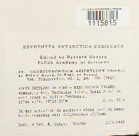 Chorisodontium aciphyllum (Hook. f. & Wilson) Broth. 75641[1115815]Ochyra, R. 544/801980-01-10 Antarctica, South Shetland Islands-King George Island: Admiralty Bay, Mackellar Inlet, Speil Point on W coast of Keller Peninsula, 62.079167 -58.425, 50m |
MIN:Bryophytes | 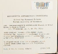 Chorisodontium aciphyllum (Hook. f. & Wilson) Broth. 756687[1115820]Ochyra, R. 5064/791979-12-27 Antarctica, South Shetland Islands-King George Island: Admiralty Bay, Jersak Hills SW of Arctowski Station and immediately S of Jardine Peak, 62.158333 -58.491667 |
MIN:Bryophytes | 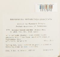 Desmatodon heimii (Hedw.) R.H. Zander 756692[1117912]Ochyra, R. 4887/791979-12-21 Antarctica, South Shetland Islands-King George Island: Admiralty Bay, Llano Point immediately south of Suszczewki Cove, 62.170833 -58.441667, 25m |
MIN:Bryophytes |  756814[1124378]Ochyra, R. 2790/801980-03-20 Antarctica, South Shetland Islands-Deception Island: Port Foster, Pendulum Cove, Mooring Post south of destroyed Chilean Station, -62.916667 -60.583333, 10m |
MIN:Bryophytes | 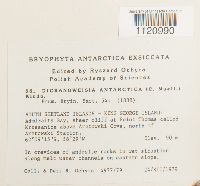 Dicranoweisia antarctica (Müll. Hal.) Paris 756815[1120990]Ochyra, R. 4977/791979-12-24 Antarctica, SOUTH SHETLAND ISLANDS - KING GEORGE ISLAND: Admiralty Bay, sheer cliff at Point Thomas called Krzesanica above Arctowski Cove, north of Arctowski Station., 9.25 -58.483333, 90m |
MIN:Bryophytes | 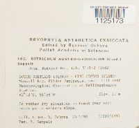 Ditrichum austrogeorgicum (Cardot) Seppelt 756765[1125173]Ochyra, R. 2405/801980-03-01 Antarctica, SOUTH SHETLAND ISLANDS - KING GEORGE ISLAND: Maxwell Bay, Fildes Peninsula, small hill near Meteorological Observatory at Bellingshausen Station., -62.2 -58.96667, 15m |
MIN:Bryophytes | 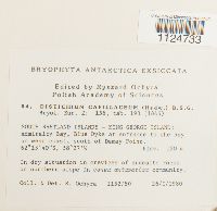 Distichium capillaceum (Hedw.) Bruch & Schimp. 756816[1124733]Ochyra, R. 1152/801980-01-26 Antarctica, SOUTH SHETLAND ISLANDS - KING GEORGE ISLAND: Admiralty Bay, Blue Dyke at entrance to the bay on west coast, south of Demay Point., -62.227778 -58.45, 120m |
MIN:Bryophytes | 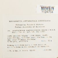 Distichium capillaceum (Hedw.) Bruch & Schimp. 756791[1124734]Ochyra, R. 528/801980-01-10 Antarctica, SOUTH SHETLAND ISLANDS - KING GEORGE ISLAND: Admiralty Bay, MacKellar Inlet, Ore Point on the west coast of Keller Peninsula., -62.07222 -58.425, 30m |
MIN:Bryophytes | 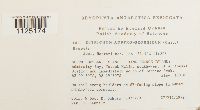 Ditrichum austrogeorgicum (Cardot) Seppelt 756689[1125174]Ochyra, R. 5072/791979-12-27 Antarctica, SOUTH SHETLAND ISLANDS - KING GEORGE ISLAND: Admiralty Bay, Jersak Hills, SW of Arctowski Station and immediately south of Jardine Peak., 62.158333 -58.491667, 100m |
MIN:Bryophytes | 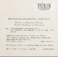 756839[1124377]Ochyra, R. 2785/801980-03-20 Antarctica, SOUTH SHETLAND ISLANDS - DECEPTION ISLAND: Port Foster, Whalers Bay, Ronald Hill above the destroyed British Station., -62.927778 -60.583333, 40m |
MIN:Bryophytes | 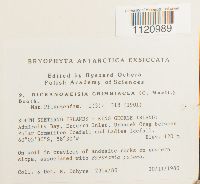 Dicranoweisia grimmiacea (Müll. Hal.) Broth. 756861[1120989]Ochyra, R. 2314/801980-02-20 Antarctica, SOUTH SHETLAND ISLANDS - KING GEORGE ISLAND: Admiralty Bay, Ezcurra Inlet, Urbanek Crag between Polar Committee Icefall and Ladies Icefall., -60.091667 -58.5, 120m |
MIN:Bryophytes |  Distichium capillaceum (Hedw.) Bruch & Schimp. 756764[1124735]Ochyra, R. 810/801980-01-18 Antarctica, SOUTH SHETLAND ISLANDS - KING GEORGE ISLAND: Admiralty Bay, nunatak Brama (=gate) between Baranowski Glacier and Tower Glacier., -62.20833 -58.46667, 200m |
MIN:Bryophytes | 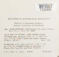 Dicranoweisia antarctica (Müll. Hal.) Paris 756688[1120996]Ochyra, R. 1930/801980-02-15 Antarctica, SOUTH SHETLAND ISLANDS - KING GEORGE ISLAND: Admiralty Bay, Komandor Peak east of Admiralen Peak between Lange Glacier and Znosko Glacier., -62.1 -58.48333, 200m |
MIN:Bryophytes | 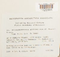 Dicranoweisia antarctica (Müll. Hal.) Paris 756789[1120991]Ochyra, R. 444/801980-01-09 Antarctica, SOUTH SHETLAND ISLANDS - KING GEORGE ISLAND: Admiralty Bay, Keller Peninsula, Mt. Birkenmajer., -3.066667 -58.483333, 270m |
MIN:Bryophytes | 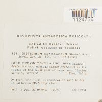 Distichium capillaceum (Hedw.) Bruch & Schimp. 756739[1124736]Ochyra, R. 730/801980-01-18 Antarctica, SOUTH SHETLAND ISLANDS - KING GEORGE ISLAND: Admiralty Bay, nunatak Siodlo (=saddle) in the middle of the lower part of Baranowski Glacier, -62.2 -58.45, 140m |
MIN:Bryophytes | 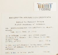 Dicranoweisia antarctica (Müll. Hal.) Paris 756788[1120992]Ochyra, R. 105/801980-01-03 Antarctica, SOUTH SHETLAND ISLANDS - KING GEORGE ISLAND: Admiralty Bay, Ezcurra Inlet, Italia Valley east of Herve Cove., -62.5 -58.516667, 100m |
MIN:Bryophytes | 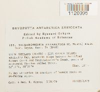 Dicranoweisia antarctica (Müll. Hal.) Paris 756711[1120995]Ochyra, R. 5126/791979-12-28 Antarctica, SOUTH SHETLAND ISLANDS - KING GEORGE ISLAND: Admiralty Bay, mountain slope between Petrified Forest Creek and Ornithologist's Creek, south of Arctowski Station called Ubocz., -62.166667 -58.483333, 130m |
MIN:Bryophytes | 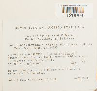 Dicranoweisia antarctica (Müll. Hal.) Paris 756762[1120993]Ochyra, R. 1698/801980-02-06 Antarctica, SOUTH SHETLAND ISLANDS - KING GEORGE ISLAND: Admiralty Bay, Ezcurra Inlet, Panorama Ridge between Point Thomas and Jardine Peak., -62.14167 -58.49167, 160m |
MIN:Bryophytes | 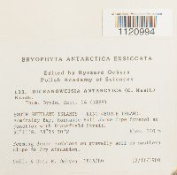 Dicranoweisia antarctica (Müll. Hal.) Paris 756737[1120994]Ochyra, R. 1845/801980-02-12 Antarctica, SOUTH SHETLAND ISLANDS - KING GEORGE ISLAND: Admiralty Bay, Harnasie Hill above Cape Syrezol at junction with Bransfield Strait., -60.183333 -58.25, 140m |
MIN:Bryophytes | 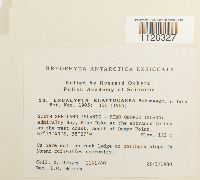 Encalypta rhaptocarpa Schwägr. 756840[1126327]Ochyra, R. 1161/801980-01-25 Antarctica, SOUTH SHETLAND ISLANDS - KING GEORGE ISLAND: Admiralty Bay, Blue Dyke at the entrance to bay on the west coast, south of Demay Point., -62.22778 -58.45, 125m |
MIN:Bryophytes | 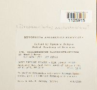 Drepanocladus austrostramineus (Müll. Hal.) Ochyra 756698[1125915]Ochyra, R. 375/801980-01-08 Antarctica, SOUTH SHETLAND ISLANDS - KING GEORGE ISLAND: Admiralty Bay, Agat Point south of Sphinx Hill., 12m |
MIN:Bryophytes | 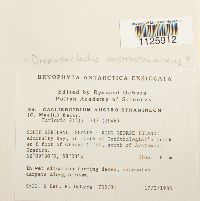 Drepanocladus austrostramineus (Müll. Hal.) Ochyra 756776[1125912]Ochyra, R. 702/801980-01-17 Antarctica, South Shetland Islands-King George Island: Admiralty Bay, at mouth of Ornithologist's Creek at E foot of Orange Cliff, S of Arctowski Station, -62.158333 -58.466667, 6m |
MIN:Bryophytes | 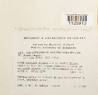 Drepanocladus austrostramineus (Müll. Hal.) Ochyra 756750[1125913]Ochyra, R. 1484/801980-02-05 Antarctica, SOUTH SHETLAND ISLANDS - KING GEORGE ISLAND: Admiralty Bay, wet meadow immediately south of Arctowski Station called Jasnorzewski Gardens, -62.15 -58.475, 4m |
MIN:Bryophytes | 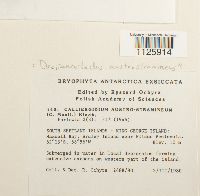 Drepanocladus austrostramineus (Müll. Hal.) Ochyra 756727[1125914]Ochyra, R. 2488/801980-03-02 Antarctica, SOUTH SHETLAND ISLANDS - KING GEORGE ISLAND: Maxwell Bay, Ardley Island near Fildes Peninsula, -62.21667 -58.93333, 10m |
MIN:Bryophytes | 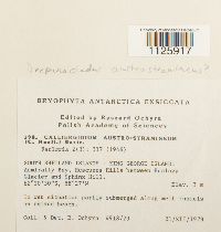 Drepanocladus austrostramineus (Müll. Hal.) Ochyra 756672[1125917]Ochyra, R. 4918/791979-12-21 Antarctica, SOUTH SHETLAND ISLANDS - KING GEORGE ISLAND: Admiralty Bay, Rescuers Hills between Ecology Glacier and Sphinx Hill., -62.175 -58.45, 3m |
MIN:Bryophytes | 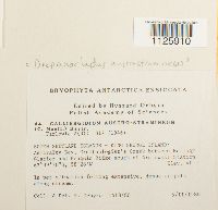 Drepanocladus austrostramineus (Müll. Hal.) Ochyra 756826[1125910]Ochyra, R. 1418/801980-02-05 Antarctica, SOUTH SHETLAND ISLANDS - KING GEORGE ISLAND: Admiralty Bay, Ornithologist's Creek between Ecology Glacier and Penguin Ridge south of Arctowski Station, -62.15833 -58.46667, 40m |
MIN:Bryophytes | 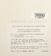 Drepanocladus austrostramineus (Müll. Hal.) Ochyra 756801[1125911]Ochyra, R. 1193/801980-01-27 Antarctica, SOUTH SHETLAND ISLANDS - KING GEORGE ISLAND: Admiralty Bay, Blue Dyke at the entrance to bay on the west coast, south of Demay Point., -62.227778 -58.45, 40m |
Google Map
Google Maps is a web mapping service provided by Google that features a map that users can pan (by dragging the mouse) and zoom (by using the mouse wheel). Collection points are displayed as colored markers that when clicked on, displays the full information for that collection. When multiple species are queried (separated by semi-colons), different colored markers denote each individual species.