University of Minnesota
http://www.umn.edu/
612-625-5000
http://www.umn.edu/
612-625-5000
Minnesota Biodiversity Atlas
Bell Museum
Dataset: MIN-Bryophytes
Search Criteria: Austria; Tirol; excluding cultivated/captive occurrences
1
Page 1, records 1-8 of 8
Bell Museum bryophytes | |
 MIN:Bryophytes | 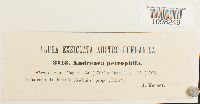 Andreaea rupestris Hedw. 27780[1098249]Kerner, A. 3113 Austria, Tirol, Gschnitz valley, near Trins, 47.0833 11.4167 |
MIN:Bryophytes | 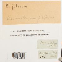 Anomobryum filiforme (Griff.) A. Jaeger 639349[1098733] 3607 Austria, Tirol, Otztal |
MIN:Bryophytes |  Anomodon attenuatus (Hedw.) Huebener 27931[1099160]E. Bauer 571901-07-00 Austria, Tirol, Imst, near Oetz |
MIN:Bryophytes | 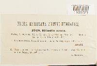 Blindia acuta (Hedw.) Bruch & Schimp. 29267[1103729]Arnold 1918 Austria, Tirol, Innsbruck Land, Gschnitz (this is site II), site I is Paneveggio near Predazzo, Trento, Italy, 1600m |
MIN:Bryophytes | 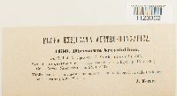 Dicranum muehlenbeckii subsp. brevifolium (Lindb.) J.J. Amann 32962[1123902]Kerner, A. 1130 Austria, Tirol, Innsbruck Land, foot of Kalbjoch, 2000m |
MIN:Bryophytes |  Ditrichum flexicaule (Schwägr.) Hampe 639891[1124995]E. Bauer 1431901-06-27 Austria, Tirol, Otztal Alps, 1100m |
MIN:Bryophytes | 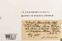 Philonotis fontana (Hedw.) Brid. 648094[1150804]Baumgartner, Jul. s.n.1905-09-21 Austria, Tirol, 2225m |
MIN:Bryophytes |  Pohlia obtusifolia (Vill. ex Brid.) L.F. Koch 640234[1156332]Osterwald, K. 19251907-08-02 Austria, Tirol, 2400m |
1
Page 1, records 1-8 of 8
Google Map
Google Maps is a web mapping service provided by Google that features a map that users can pan (by dragging the mouse) and zoom (by using the mouse wheel). Collection points are displayed as colored markers that when clicked on, displays the full information for that collection. When multiple species are queried (separated by semi-colons), different colored markers denote each individual species.