University of Minnesota
http://www.umn.edu/
612-625-5000
http://www.umn.edu/
612-625-5000
Minnesota Biodiversity Atlas
Bell Museum
Dataset: MIN-Bryophytes
Search Criteria: Chile; Magallanes; excluding cultivated/captive occurrences
1
Page 1, records 1-20 of 20
Bell Museum bryophytes | |
 MIN:Bryophytes | 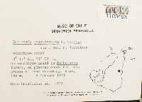 Bartramia mossmaniana Müll. Hal. 859362[1103463]Mike Ostafichuk 13701971-10-08 Chile, Magallanes, Magallanes, Brunswick Peninsula, Nothofagus forest, above Rio Tres Brazos at road crossing, -53.283333 -71.05, 160m |
MIN:Bryophytes | 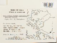 Dendroligotrichum dendroides (Brid. ex Hedw.) Broth. 859336[1117638]John J. Engel 63051969-10-09 Chile, Magallanes, Región de Magallanes y de la Antártica Chilena, Strait of Magellan: grassy slope, W side of B. San Nicolás, -53.85 -71.116667 |
MIN:Bryophytes | 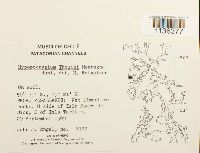 Hypopterygium thouinii (Schwägr.) Mont. 859353[1136377]Engel, John J. 51771969-09-29 Chile, Magallanes, S side of Isla Madre de Dios, N of Isla Tarlton, -50.35 -75.35 |
MIN:Bryophytes | 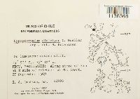 Hypopterygium didictyon Müll. Hal. 859331[1136368]Imshaug, H.A. 439961969-09-27 Chile, Magallanes, E side of entrance to Pto Alert, -49.883333 -75.2 |
MIN:Bryophytes | 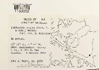 Philonotis vagans (Hook. & Wilson) Mitt. 859338[1150652]Engel, John J. 63221969-10-09 Chile, Magallanes, Grassy slope, W side B. San Nicolas, -53.85 -71.116667 |
MIN:Bryophytes | 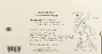 Porothamnium valdiviae (Müll. Hal.) M. Fleisch. 859387[1157859]J.J. Engel 49831969-09-27 Chile, Magallanes, fiord W of Mte Markham, Pto Alert, -49.816667 -75.266667 |
MIN:Bryophytes | 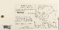 Polytrichum strictum Menzies ex Brid. 859326[1157489]Engel, John J. 64401969-10-00 Chile, Magallanes, Straight of Magellan. Prov. Magallanes: E side B. san Nicolas |
MIN:Bryophytes | 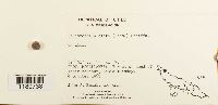 Schistochila alata (Lehm.) Stephani 859198[1180738]Engel, John J. 56411969-10-04 Chile, Magallanes, at head of inner harbour, Bahia Tuesday, -52.85 -74.516667 |
MIN:Bryophytes |  Schistochila lamellata (Hook.) Dumort. 859114[1180744]Engel, John J. 49461969-09-26 Chile, Magallanes, W side of harbour, Pto Alert. |
MIN:Bryophytes |  Schistochila sciophylla Schust. 859099[1180755]Engel, John J. 47871969-09-25 Chile, Magallanes, near E shore of Isla Pilot (Pto del Morro)., -50.05 -75.033333 |
MIN:Bryophytes |  Schistochila alata (Lehm.) Stephani 859179[1180737]John J Engel 60991969-10-07 Chile, Magallanes, Bahia Borja, ridge on E side, -53.533333 -72.5 |
MIN:Bryophytes |  Schistochila alata (Lehm.) Stephani 859044[1180739]John J Engel 50491969-09-27 Chile, Magallanes, Pto Alert (I Mornington), W side of harbour, -49.866667 -75.233333 |
MIN:Bryophytes |  Schistochila alata (Lehm.) Stephani 859113[1180741]John J Engel 49331969-09-26 Chile, Magallanes, Pto Alert, W side of harbour, -49.866667 -75.233333 |
MIN:Bryophytes |  Schistochila laminigera (Hook. f. & Taylor) A. Evans 859047[1180745]John J Engel 51251969-09-28 Chile, Magallanes, Isla Madre de Dios, head of fjord E of Mt Roberto, -50.333333 -75.35 |
MIN:Bryophytes |  Schistochila laminigera (Hook. f. & Taylor) A. Evans 859045[1180746]John J Engel 50841969-09-28 Chile, Magallanes, Isla Tarlton, NE corner, -50.35 -75.35 |
MIN:Bryophytes |  Schistochila leucophylla (Lehm.) Stephani 859192[1180748]John J Engel 55041969-10-01 Chile, Magallanes, Fiordo Peel, waterfalls at head, -54.983333 -73.783333 |
MIN:Bryophytes |  Schistochila quadrifida A. Evans 859085[1180749]John J Engel 54591969-10-01 Chile, Magallanes, Fiordo Peel, waterfalls at head, -54.983333 -73.783333 |
MIN:Bryophytes |  Schistochila sciophylla Schust. 859053[1180750]John J Engel 53231969-09-30 Chile, Magallanes, Isla Catham, N shore of B Wide, -54.65 -74.6 |
MIN:Bryophytes |  Schistochila sciophylla Schust. 859049[1180751]John J Engel 51401969-09-28 Chile, Magallanes, Isla Madre de Dios, head of fjord E of Mt Roberto, -50.333333 -75.35 |
MIN:Bryophytes |  Schistochila sciophylla Schust. 859124[1180753]John J Engel 47551969-09-25 Chile, Magallanes, E shore of Isla Pilot (Pto del Morro), -50.05 -75.033333 |
1
Page 1, records 1-20 of 20
Google Map
Google Maps is a web mapping service provided by Google that features a map that users can pan (by dragging the mouse) and zoom (by using the mouse wheel). Collection points are displayed as colored markers that when clicked on, displays the full information for that collection. When multiple species are queried (separated by semi-colons), different colored markers denote each individual species.