University of Minnesota
http://www.umn.edu/
612-625-5000
http://www.umn.edu/
612-625-5000
Minnesota Biodiversity Atlas
Bell Museum
Dataset: MIN-Bryophytes
Search Criteria: France; Savoie; excluding cultivated/captive occurrences
1
Page 1, records 1-22 of 22
Bell Museum bryophytes | |
 MIN:Bryophytes | 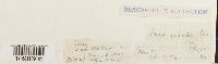 Anisothecium varium (Hedw.) Schimp. 32391[1098605]D. Subalaea [?] s.n.1860-08-08 France, Savoie |
MIN:Bryophytes | 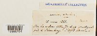 Anomodon viticulosus (Hedw.) Hook. & Taylor 28038[1099214] s.n.1861-03-16 France, Savoie, Chambery, between Jacob and Montagnol near Chambéry |
MIN:Bryophytes | 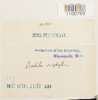 Barbula aciphylla Bruch & Schimp. 28282[1100769] s.n.1863-08-01 France, Savoie, Mont-Cenis |
MIN:Bryophytes | 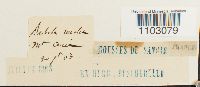 28728[1103079] s.n.1863-07-30 France, Savoie, Mont-Cenis |
MIN:Bryophytes | 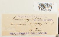 Barbula unguiculata Hedw. 28934[1103139] s.n. France, Savoie, Mont-Joigny |
MIN:Bryophytes | 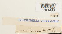 Bartramia halleriana Hedw. 29025[1103496] s.n.1860-08-10 France, Savoie |
MIN:Bryophytes | 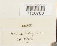 Barbula aciphylla Bruch & Schimp. 28276[1100763] s.n. France, Savoie |
MIN:Bryophytes | 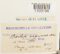 Barbula unguiculata Hedw. 28915[1103196] s.n.1865-04-04 France, Savoie |
MIN:Bryophytes | 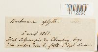 Buxbaumia aphylla Hedw. 30970[1112263] s.n.1861-04-06 France, Savoie, near Chambery |
MIN:Bryophytes | 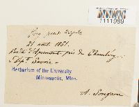 Bryum pseudotriquetrum (Hedw.) P. Gaertn., B. Mey. & Scherb. 30737[1111989]Songeon, A. s.n. France, Savoie |
MIN:Bryophytes | 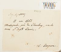 Bryum caespiticium Hedw. 30159[1111361]Songeon, A. s.n.1863-05-11 France, Savoie, Montagnole |
MIN:Bryophytes | 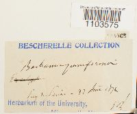 Bartramia pomiformis Hedw. 29208[1103575] s.n.1872-08-02 France, Savoie |
MIN:Bryophytes |  Bryum inclinatum (Brid.) Bland. 30453[1111647]Em. Bescherelle s.n.1865-07-28 France, Savoie, Saint Michel Montagnard, Pas du Roc |
MIN:Bryophytes |  Bryum pallescens Schleich. ex Schwägr. 30639[1111874] s.n. France, Savoie, Mont Cenis |
MIN:Bryophytes |  Bartramia pomiformis Hedw. 29227[1107640] s.n.1860-04-05 France, Savoie |
MIN:Bryophytes |  Bryum pendulum (Hornsch.) Schimp. 30684[1111895] s.n.1872-04-22 France, Savoie |
MIN:Bryophytes | 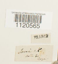 Dicranella squarrosa (Stark) Schimp. 32314[1120565] s.n.1860-08-00 France, Savoie |
MIN:Bryophytes | 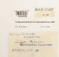 Encalypta procera Bruch 33948[1126236] s.n.1863-08-04 France, Savoie, Saint-Jean-de-Maurienne, Lanslebourg |
MIN:Bryophytes | 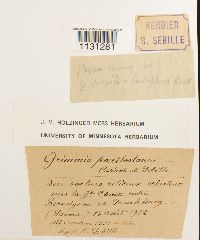 Grimmia tergestina var. poecilostoma (Cardot & Sebille) Loeske 644284[1131281]Sebille, R. s.n.1912-08-14 France, Savoie, between Germignon and Lauslebourg |
MIN:Bryophytes | 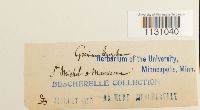 35630[1131040] s.n.1863-07-00 France, Savoie, St Michel a Maurienne [Saint-Michel-de-Maurienne] |
MIN:Bryophytes | 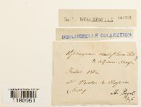 Sphagnum acutifolium Ehrh. ex Schrad. 938428[1180961]Abbé Puget 1864-07-00 France, Savoie, St Nicolas-la-Chapelle |
MIN:Bryophytes | 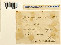 938479[1182012] 1864-00-00 France, Savoie, St Nicholas la Chapelle |
1
Page 1, records 1-22 of 22
Google Map
Google Maps is a web mapping service provided by Google that features a map that users can pan (by dragging the mouse) and zoom (by using the mouse wheel). Collection points are displayed as colored markers that when clicked on, displays the full information for that collection. When multiple species are queried (separated by semi-colons), different colored markers denote each individual species.