University of Minnesota
http://www.umn.edu/
612-625-5000
http://www.umn.edu/
612-625-5000
Minnesota Biodiversity Atlas
Bell Museum
Dataset: MIN-Bryophytes
Search Criteria: Slovakia; excluding cultivated/captive occurrences
1
Page 1, records 1-18 of 18
Bell Museum bryophytes | |
 MIN:Bryophytes | 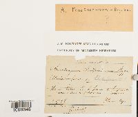 Anoectangium Schwägr. 632669[1098648]Lern s.n.1885-07-10 Slovakia, Banskobystrický, Revuca, Muran, great cavern of Mount Muran, upper Patra |
MIN:Bryophytes | 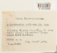 Brachythecium reflexum (Starke) Schimp. 501688[1107048]Josef Duda s.n.1949-08-01 Slovakia, Silesia. Montes Jeseniky, 1100m |
MIN:Bryophytes | 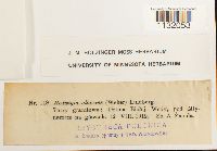 Hedwigia ciliata (Hedw.) P. Beauv. 644387[1132053]Zmuda, A. s.n.1912-08-12 Slovakia, Prešov, Poprad, Dolina Białej Wody |
MIN:Bryophytes | 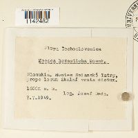 Meesia hexasticha (Funck) Bruch 501779[1142482]Duda, Josef s.n.1949-07-07 Slovakia, Belanske Tatry Mountains, 1600m |
MIN:Bryophytes | 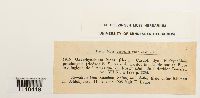 Oxyrrhynchium hians (Hedw.) Loeske 640299[1148418]Bauer, E. s.n.1925-08-11 Slovakia |
MIN:Bryophytes | 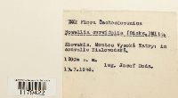 Nowellia curvifolia (Dicks.) Mitt. 501791[1179422] Slovakia |
MIN:Bryophytes | 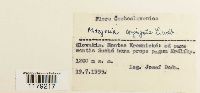 Metzgeria conjugata Lindb. 537782[1179217] Slovakia |
MIN:Bryophytes | 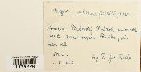 Metzgeria pubescens (Schrank) Raddi 501780[1179229] Slovakia |
MIN:Bryophytes | 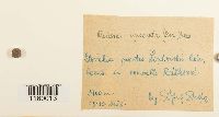 Preissia quadrata (Scop.) Nees 501813[1180013] Slovakia |
MIN:Bryophytes | 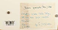 Preissia quadrata (Scop.) Nees 501814[1180014] Slovakia |
MIN:Bryophytes | 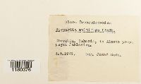 Riccardia multifida (L.) Gray 501819[1180376] Slovakia |
MIN:Bryophytes | 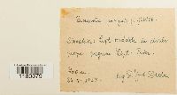 Riccardia pinguis (L.) Gray 501820[1180379] Slovakia |
MIN:Bryophytes | 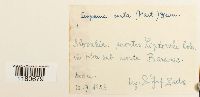 Scapania curta (Mart.) Dumort. 501822[1180679]Josef Duda 1953-07-12 Slovakia |
MIN:Bryophytes | 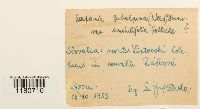 Scapania subalpina (Nees ex Lindenb.) Dumort. 501825[1180710]Josef Duda 1953-10-18 Slovakia |
MIN:Bryophytes | 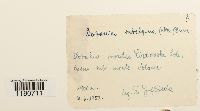 Scapania subalpina (Nees ex Lindenb.) Dumort. 501824[1180711]Josef Duda 1953-06-07 Slovakia |
MIN:Bryophytes | 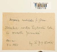 501832[1180719]Josef Duda 1953-06-07 Slovakia, 1800m |
MIN:Bryophytes | 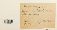 501830[1180721]Josef Duda 1952-10-19 Slovakia, 850m |
MIN:Bryophytes | 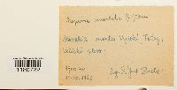 501829[1180722]Josef Duda 1953-10-11 Slovakia, Vesoky Tetry mts, Velicki, 1700m |
1
Page 1, records 1-18 of 18
Google Map
Google Maps is a web mapping service provided by Google that features a map that users can pan (by dragging the mouse) and zoom (by using the mouse wheel). Collection points are displayed as colored markers that when clicked on, displays the full information for that collection. When multiple species are queried (separated by semi-colons), different colored markers denote each individual species.