University of Minnesota
http://www.umn.edu/
612-625-5000
http://www.umn.edu/
612-625-5000
Minnesota Biodiversity Atlas
Bell Museum
Dataset: MIN-Bryophytes
Search Criteria: Sweden; Lappland; excluding cultivated/captive occurrences
1
Page 1, records 1-7 of 7
Bell Museum bryophytes | |
 MIN:Bryophytes | 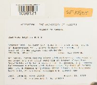 Andreaea blyttii Schimp. 731645[1098121]Dale H. Vitt 262681980-08-22 Sweden, Lappland, Norrbotten, NORRBOTTENS LAN LAPPLAND. Lake Tornetrask area: South of Kopparasen hpl, along Raikenjira stream, 17 km. East of the Norwegian-Swedish border., 450 - 1000m |
MIN:Bryophytes | 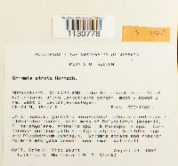 Grimmia atrata Miel. ex Hornsch. 731715[1130778]Vitt, Dale H. 263111980-08-23 Sweden, Lappland, Norrbotten, Lake Tornestrask; SE of Laktatjakka along Laktatjakka stream; about 2 km west of Laktatjakkastugan, 68.4 18.45, 900 - 1100m |
MIN:Bryophytes | 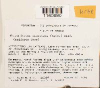 Racomitrium canescens (Hedw.) Bednarek-Ochyra & Ochyra 731688[1160890]Dale H. Vitt 262691980-08-22 Sweden, Lappland, Norrbotten, NORRBOTTENS LAN LAPPLAND. Lake Tornetrask area: South of Kopparasen hpl, along Raikenjira stream, 17 km. East of the Norwegian-Swedish border.; 68.416667 18.516667, 68.416667 18.516667, 450 - 1000m |
MIN:Bryophytes |  Racomitrium lanuginosum (Hedw.) Brid. 731642[1161040]Dale H. Vitt 262141980-08-12 Sweden, Lappland, Norrbottens, NORRBOTTENS LAN LAPPLAND. Lake Tornetrask area: Riksgransen hpl, NNE slope of Katternjunnje, 63.416667 18.116667, 550 - 800m |
MIN:Bryophytes |  Polytrichum commune var. jensenii I. Hagen 731653[1157559]Vitt, Dale H. 263501980-08-23 Sweden, Lappland, Norrbottens Lan Lappland; Lake Tornetrask area; SE of Laktatjakka along Laktathakka stream, mostly about 2 km. West of Laktatjakkastugan.; 68.4 18.45, 68.4 18.45, 900 - 1100m |
MIN:Bryophytes |  Pohlia drummondii (Müll. Hal.) A.L. Andrews 731647[1156197]Vitt, Dale H. 262581980-08-22 Sweden, Lappland, Norrbotten, NORRBOTTENS LAN LAPPLAND. Lake Tornetrask area: South of Kopparasen hpl, along Raikenjira stream, 17 km. East of the Norwegian-Swedish border., 68.416667 18.516667, 450 - 1000m |
MIN:Bryophytes |  Sphagnum acutifolium Ehrh. ex Schrad. 938432[1180965] Sweden, Lappland, Västerbotten, Lycksele |
1
Page 1, records 1-7 of 7
Google Map
Google Maps is a web mapping service provided by Google that features a map that users can pan (by dragging the mouse) and zoom (by using the mouse wheel). Collection points are displayed as colored markers that when clicked on, displays the full information for that collection. When multiple species are queried (separated by semi-colons), different colored markers denote each individual species.