University of Minnesota
http://www.umn.edu/
612-625-5000
http://www.umn.edu/
612-625-5000
Minnesota Biodiversity Atlas
Bell Museum
Dataset: MIN-Bryophytes
Taxa: Erpodiaceae
Search Criteria: excluding cultivated/captive occurrences
1
Page 1, records 1-9 of 9
Bell Museum bryophytes | |
 MIN:Bryophytes |  Venturiella sinensis (Venturi) Müll. Hal. 788581[1172974]Osada, T. 1841972-02-02 Japan, Kyushu, Fukuoka-ken, Chikushi-gun, Dazaifumachi, Kanzeonji, 35m |
MIN:Bryophytes |  Erpodium biseriatum (Austin) Steere 850350[1126868]Pocs, T. 1611972-07-12 Tanzania, United Republic of, East foothills of Uluguru Mts. near Matombo; in Kimboza Forest Reserve, 300m |
MIN:Bryophytes |  Erpodium biseriatum (Austin) Steere 876004[1126866]Heinar Streimann 550511999-08-20 Australia, Queensland, Wilsons Beach, 17 km SE of Proserpine, 6m |
MIN:Bryophytes |  Erpodium domingense (Spreng.) Brid. 385432[1126865]Runyon, Robert 4641944-02-00 United States, Texas, Cameron |
MIN:Bryophytes | 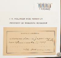 Aulacopilum japonicum Broth. ex Cardot 635525[1100449]Okamura, Sh. s.n.1907-07-00 Japan |
MIN:Bryophytes | 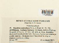 Erpodium australiense I.G. Stone 864394[1126867]Heinar Streimann 486591991-07-20 Australia, Northern Territory, Mt Bundy, Arnhem Highway, 93 km SE of Darwin, -12.88333 131.6, 40m |
MIN:Bryophytes | 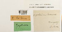 643239[1126870]Balansa s.n. Paraguay |
MIN:Bryophytes | 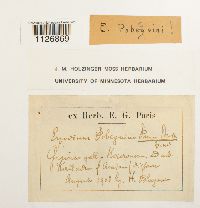 643241[1126869]Pobegmin [?] s.n.1903-08-00 Kailada [?], [illegible] |
MIN:Bryophytes | 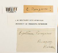 Erpodium paraguense Besch. 643240[1126871] s.n. Paraguay, Balarssa [?] |
1
Page 1, records 1-9 of 9
Google Map
Google Maps is a web mapping service provided by Google that features a map that users can pan (by dragging the mouse) and zoom (by using the mouse wheel). Collection points are displayed as colored markers that when clicked on, displays the full information for that collection. When multiple species are queried (separated by semi-colons), different colored markers denote each individual species.