University of Minnesota
http://www.umn.edu/
612-625-5000
http://www.umn.edu/
612-625-5000
Minnesota Biodiversity Atlas
Bell Museum
Dataset: MIN-Bryophytes
Taxa: Mniaceae
Search Criteria: excluding cultivated/captive occurrences
Bell Museum bryophytes | |
 MIN:Bryophytes |  Mnium Hedw. 647070[1142281]Sandberg, J. 51891-00-00 |
MIN:Bryophytes |  Mnium Hedw. 39360[1142521]Hone, Daisy 2391903-07-00 Canada, British Columbia, Port Renfew, Vancouver Island, B.C. |
MIN:Bryophytes |  Mnium Hedw. 590891[1142270]Bailey, W.M. 18951952-03-16 United States, Illinois, Hardin, along creek near Kaskaskia Exp. Forest. T11S R8W 33 |
MIN:Bryophytes |  Mnium Hedw. 55490[1142271]Steele, E. S. s.n.1897-07-13 United States, Washington D.C. and vicinity |
MIN:Bryophytes |  Mnium Hedw. 39799[1142272] 1791891-05-00 United States, Idaho, Kootenai |
MIN:Bryophytes |  Mnium Hedw. 39358[1142273]Cooper, W. S. 1631909-07-22 United States, Minnesota, Tobin's Harbor, Isle Royale |
MIN:Bryophytes |  Mnium Hedw. 524208[1142274] s.n.1902-07-05 United States, Michigan |
MIN:Bryophytes |  Mnium Hedw. 647076[1142275] 53 |
MIN:Bryophytes |  Mnium Hedw. 647075[1142276]Aiken, Walter H. s.n.1900-04-30 College Hill |
MIN:Bryophytes |  Mnium Hedw. 647074[1142277]Baker, C. F. 1191899-08-00 United States, Colorado, Near Pagosa Peak, 2743m |
MIN:Bryophytes |  Mnium Hedw. 647073[1142278]Williams, R.S. 3701896-08-14 United States, Montana, 1372m |
MIN:Bryophytes |  Mnium Hedw. 647072[1142279] 1892-04-17 |
MIN:Bryophytes |  Mnium Hedw. 647071[1142280]Wooton, E.O. 231910-08-10 United States, New Mexico, Rio Pueblo |
MIN:Bryophytes |  Mnium Hedw. 39560[1142282]Macoun, J. 581 [?]1891-06-06 Canada, Whirlpool, Niagra Falls |
MIN:Bryophytes |  Mnium Hedw. 647145[1142283]Holzinger, J.M. 321896-05-27 United States, Colorado, near Breckenridge, 110 miles from Denver, on the South Park Line of the Union Pacific Railway, 3048m |
MIN:Bryophytes |  Mnium Hedw. 39359[1142520]Hone, Daisy s.n.1902-07-00 Canada, British Columbia, Port Renfew. Vancouver Island. |
MIN:Bryophytes | 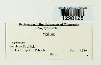 Mnium Hedw. [1298125]F. H. Erbisch 2329 USA, Michigan, Houghton |
MIN:Bryophytes | 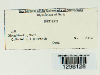 Mnium Hedw. [1298128]F. H. Erbisch 2342 USA, Michigan, Houghton |
MIN:Bryophytes |  Mnium Hedw. 957408[1298134]F. H. Erbisch 18431967-07-18 USA, Michigan, Houghton, 8 mi. in from M26 near Lake Gerlad T25N, R35W, Sec. 32- along logging road |
MIN:Bryophytes |  Mnium Hedw. [1298135]F. H. Erbisch 18441967-07-18 USA, Michigan, Houghton, 8 mi. in from M26 near Lake Gerlad T25N, R35W, Sec. 32- along logging road |
MIN:Bryophytes |  Mnium Hedw. [1298137]F. H. Erbisch 18551967-07-18 USA, Michigan, Houghton, 8 mi. in from M26 near Lake Gerald, T52N, R35W, Sec. 32- |
MIN:Bryophytes |  Mnium Hedw. [1298139]F. H. Erbisch 18661967-07-20 USA, Michigan, Houghton, Along road 2 mi. east of M 26 (near Twin Lakes) Houghton Co. T52N, R36W, along the line Of Sec. 27 and 34 |
MIN:Bryophytes |  Mnium Hedw. [1298141]F. H. Erbisch 18731967-07-20 USA, Michigan, Houghton, Along road 2 mi. east of M 26 (near Twin Lakes) Houghton Co. T52N, R36W, along the line Of Sec. 27 and 34 |
MIN:Bryophytes |  Mnium Hedw. 957417[1298143]F. H. Erbisch 18801967-07-20 USA, Michigan, Houghton, Along road 2 mi. east of M 26 (near Twin Lakes) Houghton Co. T52N, R36W, along the line Of Sec. 27 and 34 |
MIN:Bryophytes |  Mnium Hedw. [1298158]F. H. Erbisch 27161968-08-13 USA, Michigan, Baraga, 1 1/2 mile line along section line between sec. 19 and 20 then into section 29; Area 1 east side of road T51N R30W |
MIN:Bryophytes |  Mnium Hedw. [1298159]F. H. Erbisch 27171968-08-13 USA, Michigan, Baraga, 1 1/2 mile line along section line between sec. 19 and 20 then into section 29; Area 1 east side of road, T51N R30W |
MIN:Bryophytes |  Mnium Hedw. [1298163]F. H. Erbisch 27261968-08-13 USA, Michigan, Baraga, 1 1/2 mile line along section line between sec. 19 and 20 then into section 29; Area 2, left 500' further down road (east) T51N R30W |
MIN:Bryophytes |  Mnium Hedw. 957446[1298172]F. H. Erbisch 27401968-06-13 USA, Michigan, Baraga, 1 1/2 mi Baraga Co. line along sec. line between sec. 19 & 20 into sec. 29. Area 2, left 500' further down road, but more open (east), T51N, R30W |
MIN:Bryophytes |  Mnium Hedw. [1298242]F H Erbisch 2280 USA, Michigan, Ontonagon |
MIN:Bryophytes |  Mnium Hedw. 957533[1298259]F H Erbisch 2795 USA, Michigan, Baraga |
MIN:Bryophytes |  Mnium Hedw. 957552[1298278]F H Erbisch 23691968-06-21 United States, Michigan, Houghton, Prickett Dam Backwater, 46.7167 -88.6667 |
MIN:Bryophytes |  Mnium Hedw. [1298289]F H Erbisch 21611967-08-11 United States, Michigan, Ontonagon, Firesteel River |
MIN:Bryophytes | 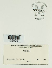 Mnium Hedw. 957565[1298291]F H Erbisch 21961967-08-11 United States, Michigan, Ontonagon, Ontonagon, At E Edge of |
MIN:Bryophytes | 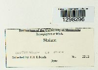 Mnium Hedw. [1298296]F H Erbisch 2212 USA, Michigan, Ontonagon |
MIN:Bryophytes | 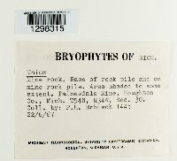 Mnium Hedw. [1298315]Erbisch, F. H. 14451967-06-22 United States, Michigan, Houghton, Painesdale Mine, T54N, R34W, Sec. 30 |
MIN:Bryophytes | 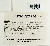 Mnium Hedw. [1298319]Erbisch, F. H. 24831968-07-11 United States, Michigan, Keweenaw, Collections along line 95+ 00E in Sec. 27, R28W, T58N |
MIN:Bryophytes |  Mnium Hedw. 957600[1298326]F H Erbisch 25151968-07-11 United States, Michigan, Keweenaw, Sec.27, R28W, T58N, Collections along line 95E 6 + SOS |
MIN:Bryophytes |  Mnium Hedw. [1298330]F H Erbisch 27821968-06-13 USA, Michigan, Baraga |
MIN:Bryophytes |  Mnium Hedw. [1298332]F H Erbisch 27721968-08-13 United States, Michigan, Baraga, along logging road, 1.5 mi Baraga Co line, 46.801288 -88.160584 |
MIN:Bryophytes |  Mnium Hedw. [1298336]F H Erbisch 27631968-08-13 United States, Michigan, Baraga, L'Anse, 11 Mi Ne of. along a logging road, 1% mi. Baraga Co. line along a seal line between sec. 19 & 20, & into sec. 29, 46.801288 -88.160584 |
MIN:Bryophytes |  Mnium Hedw. 957612[1298338]F H Erbisch 27911968-06-13 USA, Michigan, Baraga |
MIN:Bryophytes |  Mnium Hedw. [1298343]Erbisch, F.H. 17941967-07-13 United States, Michigan, Hought, Freda, Mi. T55N, R25W, Sec. 25, timbers near Freda Stampling Mill |
MIN:Bryophytes |  Mnium Hedw. 957629[1298355]Erbisch, F.H. 15021967-06-22 United States, Michigan, Keweenaw |
MIN:Bryophytes |  Mnium Hedw. 957638[1298364]F H Erbisch 24021968-06-27 USA, Michigan, Keweenaw |
MIN:Bryophytes |  Mnium Hedw. [1298366]F H Erbisch 25511968-07-11 United States, Michigan, Keweenaw, Rhyolite & Bohemia Col. |
MIN:Bryophytes |  Mnium Hedw. 957641[1298367]Erbisch, F. H. 25531968-07-11 United States, Michigan, Keweenaw, 95E 10 + 50S. 5 Sec. 27, R28W T58N |
MIN:Bryophytes |  Mnium Hedw. [1298382]F. H. Erbisch 2147 United States, Michigan |
MIN:Bryophytes |  Mnium Hedw. [1298384]F. H. Erbisch 26341968-07-30 United States, Michigan, Keweenaw, Along survey line 125 from baseline to Lake Superior (sec. 27 and 35); Site 5- 57+ OOS; R28W T58N |
MIN:Bryophytes |  Mnium Hedw. [1298391]F. H. Erbisch 26691968-07-30 United States, Michigan, Keweenaw, Along survey line 125 from baseline to Lake Superior (sec. 27 and 35). Site 7- 52 + 00S. R28W T58N |
MIN:Bryophytes |  Mnium Hedw. [1298396]F. H. Erbisch 24381968-06-27 United States, Michigan, Keweenaw, Collection areas near Smith Brothers Fisheries. Collected near marker MH-12 17 + 005. Sec. 29 R28W T58N |
MIN:Bryophytes |  Mnium Hedw. 957674[1298400]F. H. Erbisch 17991967-07-13 United States, Michigan, Houghton, 3.6 mi. south of the Freda Road entrance near Beacon Hill - 3 mi. on main logging road and .6 mi. west on secondary logging road. T54N, R36W, Sec. 1 &/or 12 |
MIN:Bryophytes |  Mnium Hedw. [1298404]F. H. Erbisch 15021967-06-22 United States, Michigan, Keweenaw |
MIN:Bryophytes |  Mnium Hedw. [1298406]F. H. Erbisch 15291967-06-26 United States, Michigan, Houghton, Lake Perrault. T54N, R35W, Sec. 34 |
MIN:Bryophytes |  Mnium Hedw. 957691[1298417]F. H. Erbisch 19191967-07-20 United States, Michigan, Houghton, On logging road about 3 miles in from M26 (near Wyandotte golf course). T52N, R36W, Sec. 18 SW corner |
MIN:Bryophytes |  Mnium Hedw. [1298427]F. H. Erbisch 27561968-06-13 United States, Michigan, Baraga, T51N, R30W, left 500' on the west side of the road, 1 1/2 mi. Baraga. Co. line along a sec. line between sec. 19 & 20, & into see. 29 |
MIN:Bryophytes |  Mnium Hedw. 957706[1298432]F. H. Erbisch 20101967-07-25 United States, Michigan, Houghton, T56N, R32W, sec 35 NW corner |
MIN:Bryophytes |  Mnium Hedw. [1298438]F. H. Erbisch 28751968-08-13 United States, Michigan, Baraga, T25N, R30W, along the southern shore of Lake Superior, Area 1, 100' further south of addit area |
MIN:Bryophytes |  Mnium Hedw. [1298457]F H Erbisch 17051967-07-06 United States, Michigan, Houghton, Traverse Point, Lake Superior |
MIN:Bryophytes |  Mnium Hedw. 957734[1298460]F. H. Erbisch 29071968-09-02 United States, Ohio, Coreen Co. Clifton gorge, gorge of little Miami River |
MIN:Bryophytes |  Mnium Hedw. [1298480]S. K. Harris 172571939-04-22 [no info] |
MIN:Bryophytes | 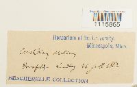 Cinclidium arcticum (Bruch & Schimp.) Schimp. 31545[1115865] s.n.1882-06-26 |
MIN:Bryophytes | 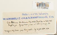 Cinclidium arcticum (Bruch & Schimp.) Schimp. 31542[1115862] s.n.1898-00-00 Norway, Innlandet, Dovre, Kongsvold? |
MIN:Bryophytes | 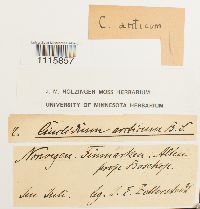 Cinclidium arcticum (Bruch & Schimp.) Schimp. 641690[1115857]J.E. Zetterstedt 2 |
MIN:Bryophytes | 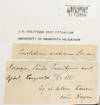 Cinclidium arcticum (Bruch & Schimp.) Schimp. 641688[1115859]Kaurin s.n.1883-07-17 |
MIN:Bryophytes | 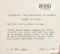 Cinclidium arcticum (Bruch & Schimp.) Schimp. 688765[1115833]D.H. Vitt 160941976-07-10 Canada, Yukon, Bonnet Plume Range, Pinguicula Lake, 853 - 975m |
MIN:Bryophytes | 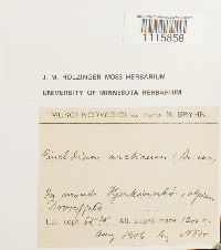 Cinclidium arcticum (Bruch & Schimp.) Schimp. 641689[1115858]N. Bryhn s.n.1906-08-00 Norway, 1200m |
MIN:Bryophytes | 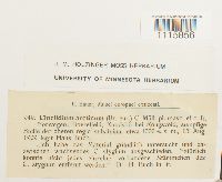 Cinclidium arcticum (Bruch & Schimp.) Schimp. 639863[1115856]Hans Buch 9491909-08-13 1000m |
MIN:Bryophytes | 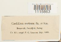 Cinclidium arcticum (Bruch & Schimp.) Schimp. 31543[1115863] s.n.1868-09-00 Norway, Dovre: Kongsvoll |
MIN:Bryophytes | 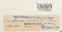 Cinclidium arcticum (Bruch & Schimp.) Schimp. 31544[1115864]Kids s.n. |
MIN:Bryophytes | 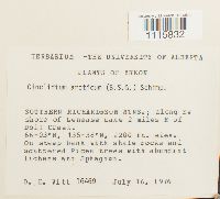 Cinclidium arcticum (Bruch & Schimp.) Schimp. 688809[1115832]D.H. Vitt 164691976-07-16 Canada, Yukon, Southern Richardson Mtns. Along SW shore of Lenense Lake 2 mi. E of Doll Creek, 66.05 -135.633333, 671m |
MIN:Bryophytes | 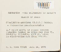 Cinclidium arcticum (Bruch & Schimp.) Schimp. 688836[1115826]D.H. Vitt 170911976-07-24 Canada, Yukon, Yukon, 2.7 miles N of Yukon-British Columbia border on Atlin Hwy (Hwy 7), 60.033333 -133.8, 762m |
MIN:Bryophytes |  Cinclidium arcticum (Bruch & Schimp.) Schimp. 31541[1115827]Berggren, S. s.n.1868-00-00 Norway, Prince Charles Foreland |
MIN:Bryophytes |  Cinclidium arcticum (Bruch & Schimp.) Schimp. 668680[1115828]Steere, W.C. 271960-08-03 United States, Alaska, Colville River, Umiat., 69.36667 -152.13333 |
MIN:Bryophytes |  Cinclidium arcticum (Bruch & Schimp.) Schimp. 688972[1115831]K.A. Holmen 521956-09-03 Greenland, Qaasuitsup, Nugssauq Peninsula, Marrait Kangigdlit, 70.5 -54.166667 |
MIN:Bryophytes |  Cinclidium arcticum (Bruch & Schimp.) Schimp. 641687[1115860]Hoffslad, A. s.n.1896-07-17 Norway, Finnmark, Bossekop |
MIN:Bryophytes | 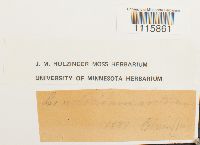 Cinclidium arcticum (Bruch & Schimp.) Schimp. 641686[1115861] s.n.1887-00-00 |
MIN:Bryophytes | 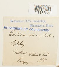 Cinclidium arcticum (Bruch & Schimp.) Schimp. 31546[1115866] s.n.1868-00-00 Norway, Prince Charles Foreland |
MIN:Bryophytes | 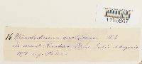 Cinclidium arcticum (Bruch & Schimp.) Schimp. 31547[1115867] s.n.1878-00-00 Norway, Innlandet, Dovre |
MIN:Bryophytes | 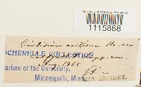 Cinclidium arcticum (Bruch & Schimp.) Schimp. 31548[1115868] s.n.1869-08-00 |
MIN:Bryophytes |  Cinclidium arcticum (Bruch & Schimp.) Schimp. 31549[1115869]Zetterstedt, J. E. s.n.1870-07-27 Norway, Dovre, Drivstuen |
MIN:Bryophytes | 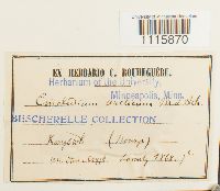 Cinclidium arcticum (Bruch & Schimp.) Schimp. 31550[1115870] s.n.1868-00-00 Norway, Kongsvol? |
MIN:Bryophytes | 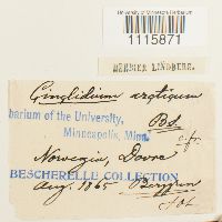 Cinclidium arcticum (Bruch & Schimp.) Schimp. 31551[1115871]Lindberg, S.O. s.n.1865-08-00 |
MIN:Bryophytes | 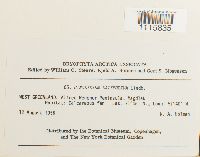 Cinclidium latifolium Lindb. 688959[1115835]K.A. Holmen 651956-08-12 Greenland, West Greenland: Alfred Wegener Peninsula, Magdlak, 71.1 -51.666667 |
MIN:Bryophytes | 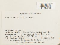 Cinclidium latifolium Lindb. 703530[1115830]Ireland, R.R. 180521978-08-11 Canada, Ontario, Carleton, Rideau Twp, Marlborough Ward, Klondyke Rd, 3 mi west of North Gower, 45.066667 -76.85 |
MIN:Bryophytes | 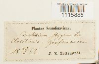 31565[1115886]J.E. Zetterstedt s.n.1868-10-06 |
MIN:Bryophytes | 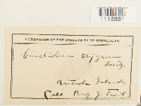 31560[1115881]J. Trail s.n. British Islands |
MIN:Bryophytes | 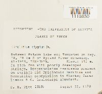 703264[1115850]D.H. Witt 238361978-08-22 Canada, Yukon, Yukon, Between Watson Lake and Tunsten on hwy 10, 19 km S of Hyland River crossing, 61.316667 -128.266667, 910m |
MIN:Bryophytes |  31570[1116813] s.n.1863-07-30 France, Mont Cenis |
MIN:Bryophytes | 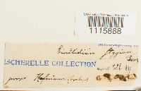 31567[1115888] s.n.1897-00-00 |
MIN:Bryophytes | 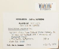 748852[1115825]Jan. A. Janssens 89291982-07-08 United States, Minnesota, Koochiching, Waskish Area: Pine Island State Forest, 14 km east of Waskish and 2 km north of Tamarack River, 48.198333 -94.323889, 365m |
MIN:Bryophytes | 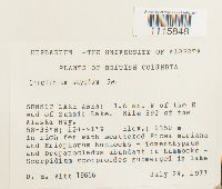 703275[1115848]Dale H. Vitt 196661977-07-24 Canada, British Columbia, Northern Rockies, SUMMIT LAKE AREA: 1.6 mi. W of the E end of Summit Lake. Mile 392 of the Alaska Hwy., 58.633333 -124.683333, 1350m |
MIN:Bryophytes |  688944[1115834]K.A. Holmen 801956-06-09 Greenland, Kitaa, WEST GREENLAND: Disko Island, Godhavn, 69.25 -53.55 |
MIN:Bryophytes | 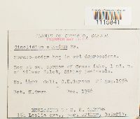 547915[1115841]C.E. Garton 44091956-08-25 Canada, Ontario, SW corner of Grass Lake, 1 mi. N of Silver Islet, Sibley Peninsula., 48.343333 -88.810278 |
MIN:Bryophytes | 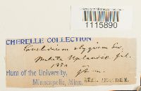 31569[1115890] s.n.1850-00-00 |
MIN:Bryophytes | 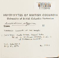 677415[1115846]Schofield, W.B. 562751974-07-17 Canada, British Columbia, Windy Point, McLeod Lake, 96 mi. n. of Prince George, 1 mi. s. of MacKenzie turnoff., 55.116184 -122.986654 |
MIN:Bryophytes |  63776[1115873] 1220 |
MIN:Bryophytes | 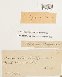 641698[1115874]Kaurin s.n.1883-00-00 Norway |
MIN:Bryophytes | 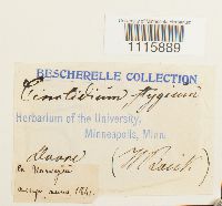 31568[1115889] s.n. |
MIN:Bryophytes | 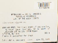 809593[1115824]Jan A. Janssens 123271984-06-13 United States, Minnesota, Lake of the Woods, Warroad Area: fen track south of bog complex, Mulligan Lake Peatland, 42 km south of Warroad (SE NW), 48.55 -95.25 |
MIN:Bryophytes |  809531[1115823]Jan A. Janssens 123551984-06-14 United States, Minnesota, Koochiching, Silverdale Area: Net Lake Spring Fen, 10 km N of Silverdale, 1 km N of Hwy 65 (TRS: T.65N, R.22W, Sec. 33) SE NE of Sec. 33., 48.083333 -93.166667, 390m |
Google Map
Google Maps is a web mapping service provided by Google that features a map that users can pan (by dragging the mouse) and zoom (by using the mouse wheel). Collection points are displayed as colored markers that when clicked on, displays the full information for that collection. When multiple species are queried (separated by semi-colons), different colored markers denote each individual species.