University of Minnesota
http://www.umn.edu/
612-625-5000
http://www.umn.edu/
612-625-5000
Minnesota Biodiversity Atlas
Bell Museum
Dataset: All Collections
Taxa: Mesoptychia gillmanii (Lophozia gillmanii, Leiocolea gillmanii, Lophozea kaurini, Jungermannia gillmanii, Jungermannia kaurinii, Leiocolea kaurinii, Lophozia kaurinii, Leiocolea gillmanii f. gillmanii, Leiocolea gillmanii f. orbiculata, Lophozia gillmanii f. gillmanii, Lophozia gillmanii f. heterogyna, Lophozia gillmanii f. orbiculata, Lophozia gillmanii var. ciliolata, Lophozia gillmanii var. gillmanii, Jungermannia kaurinii f. densifolia, Jungermannia kaurinii f. gracilis-et-atra, Jungermannia kaurinii var. kaurinii)
Search Criteria: Bell Museum bryophytes; Minnesota; excluding cultivated/captive occurrences
1
Page 1, records 1-1 of 1
Bell Museum bryophytes | |
 MIN:Bryophytes | 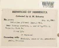 Lophozia gillmanii (Austin) R.M. Schust. 409474[1174709]Schuster, R.M. 133801948-08-16 United States, Minnesota, Cook, south end of Lucille Island, Susie Islands |
1
Page 1, records 1-1 of 1
Google Map
Google Maps is a web mapping service provided by Google that features a map that users can pan (by dragging the mouse) and zoom (by using the mouse wheel). Collection points are displayed as colored markers that when clicked on, displays the full information for that collection. When multiple species are queried (separated by semi-colons), different colored markers denote each individual species.