University of Minnesota
http://www.umn.edu/
612-625-5000
http://www.umn.edu/
612-625-5000
Minnesota Biodiversity Atlas
Bell Museum
Dataset: All Collections
Taxa: Riccia fluitans (Riccia rhenana, Riccia centrifuga, Riccia eudichotoma, Riccia fluitans subf. fluitans, Riccia media, Riccia nodosa, Fysonia tenera, Ricciella fluitans, Ricciella minor, Ricciella nodosa, Riccia canaliculata f. fluitans, Riccia fluitans f. aquatica, Riccia fluitans f. fluitans, Riccia fluitans f. gracilis, Riccia fluitans f. lata, Riccia fluitans f. limicola, Riccia fluitans f. nodosa, Riccia fluitans f. terrestris, Riccia fluitans subsp. fluitans, Riccia fluitans var. bulbifera, Riccia fluitans var. fluitans, Riccia fluitans var. reticulata, Riccia fluitans var. terrestris, Riccia huebeneriana f. natans, Riccia huebeneriana var. natans, Riccia rhenana f. aquatica, Ricciocarpos natans var. decipiens, Riccia pseudofrostii f. natans, Ricciella fluitans f. fluitans, Ricciella fluitans f. robusta, Ricciella fluitans f. subterrestris, Ricciella fluitans var. fluitans, Ricciella huebeneriana var. natans), Riccia fluitans var. nana, Riccia fluitans var. pallida, Riccia fluitans var. viridescens
Search Criteria: Bell Museum bryophytes; Minnesota; excluding cultivated/captive occurrences
1
Page 1, records 1-23 of 23
Bell Museum bryophytes | |
 MIN:Bryophytes | 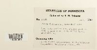 411830[1180386]Schuster, R.M. 174601948-06-00 United States, Minnesota, Sherburne, n.w. of Elk River |
MIN:Bryophytes | 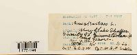 382461[1175494]Mary C Van Wert H-361930-04-13 United States, Minnesota, shore of Lake Shaffer, vicinity of Minnetonka, 274m |
MIN:Bryophytes | 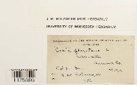 651812[1175505]Holzinger, J.M. 1902-10-31 United States, Minnesota, Winona, Lamoille, 44.000269 -91.473139 |
MIN:Bryophytes | 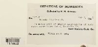 392340[1175502]Schuster, R.M. 100471948-05-05 United States, Minnesota, Hennepin, near Moore Lake |
MIN:Bryophytes | 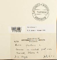 552268[1175495]J. B. Moyle 41731947-07-07 United States, Minnesota, Stevens, near Hancock |
MIN:Bryophytes | 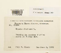 542523[1175496]John W Moore 216941952-06-03 United States, Minnesota, Brown, 2 miles north of Sleepy Eye |
MIN:Bryophytes | 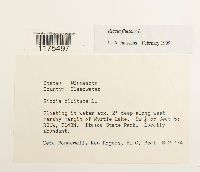 649439[1175497]Bonnewell, Veta 1974-08-02 United States, Minnesota, Clearwater, west margin of Myrtle Lake, Itasca State Park |
MIN:Bryophytes | 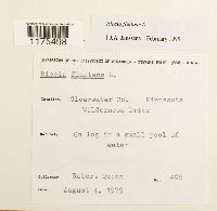 733486[1175498]Quinn, Robert 4081979-08-04 United States, Minnesota, Clearwater, Wilderness Drive |
MIN:Bryophytes |  412999[1175499]John W Moore 118551939-08-17 United States, Minnesota, Koochiching, Tilson creek near the road bridge, Rainy Lake |
MIN:Bryophytes |  402266[1175500]Schuster, R.M. 148231947-06-20 United States, Minnesota, Ramsey, Fridley Sand Dunes, near Columbia Heights |
MIN:Bryophytes |  398072[1175501]Schuster, R.M. 135421947-06-20 United States, Minnesota, Anoka, Bunker Sand Dunes, 45.203854 -93.285507 |
MIN:Bryophytes |  26979[1175503] 1891-00-00 United States, Minnesota |
MIN:Bryophytes | 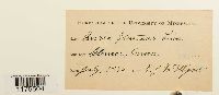 26980[1175504]McElligott, T.J. 1890-07-00 United States, Minnesota, Glencoe |
MIN:Bryophytes | 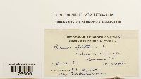 651811[1175506]P C Meyers 1904-10-00 United States, Minnesota, Winona, edge of Winona |
MIN:Bryophytes | 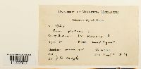 359015[1175507]J. B. Moyle 33271939-09-07 United States, Minnesota, Morrison, Nakatippi R. |
MIN:Bryophytes | 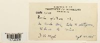 332307[1175508]J. B. Moyle 25501935-09-24 United States, Minnesota, Saint louis, in Durk Bay, Lake Kabetogama |
MIN:Bryophytes |  552245[1175509]J. B. Moyle 41831944-09-21 United States, Minnesota, Saint louis, Wolf Lake flowage |
MIN:Bryophytes | 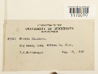 263727[1175510]P K Nurnberger P28311928-08-10 United States, Minnesota, Aitkin, Big Sandy Lake |
MIN:Bryophytes |  462766[1175511]Olga Lakela 147231952-07-10 United States, Minnesota, Saint louis, Cranberry Bay, Rainy Lake |
MIN:Bryophytes |  402517[1175512]Paul H Monson 58911983-09-04 United States, Minnesota, Saint louis, Namakan Lake, Holst Bay. Beaver pond along Ry grade, south of research station |
MIN:Bryophytes | 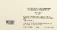 909988[1180385]Anita F Cholewa 26252008-10-11 United States, Minnesota, Sherburne, Sherburne National Wildlife Refuge, northeast end of Nelson Pool on Wildlife Drive |
MIN:Bryophytes | 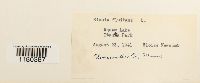 400876[1180387]Eloise Newcomb 1941-08-23 United States, Minnesota, Clearwater, Squaw Lake, Itasca Park |
MIN:Bryophytes | 955940[]Bourdaghs, M. 2017-08-08 United States, Minnesota, Anoka, Martin Lake, Aprox 2mi W. MPCA wetland monitoring site 12ANOK168, 45.3856815 -93.13933845 |
1
Page 1, records 1-23 of 23
Google Map
Google Maps is a web mapping service provided by Google that features a map that users can pan (by dragging the mouse) and zoom (by using the mouse wheel). Collection points are displayed as colored markers that when clicked on, displays the full information for that collection. When multiple species are queried (separated by semi-colons), different colored markers denote each individual species.