University of Minnesota
http://www.umn.edu/
612-625-5000
http://www.umn.edu/
612-625-5000
Minnesota Biodiversity Atlas
Bell Museum
Dataset: All Collections
Taxa: Philonotis (Mielichhoferia compacta)
Search Criteria: Bell Museum bryophytes; Minnesota; excluding cultivated/captive occurrences
1
Page 1, records 1-36 of 36
Bell Museum bryophytes | |
 MIN:Bryophytes | 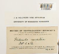 Philonotis fontana var. caespitosa (Jur.) Limpr. 647892[1148987]Holzinger, J.M. s.n.1902-08-15 United States, Minnesota, on Hat Point, a peninsula projecting southward from Mt. Josephine, into Lake Superior, near Grand Portage, lat. 48-N |
MIN:Bryophytes | 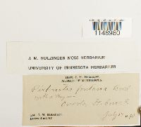 Philonotis fontana (Hedw.) Brid. 647679[1148980]Holzinger, J.M. s.n.1890-07-17 United States, Minnesota, Osceloa, St. Croix R. |
MIN:Bryophytes | 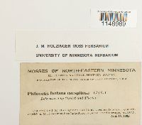 Philonotis fontana var. caespitosa (Jur.) Limpr. 647944[1148989]Holzinger, J.M. s.n.1902-08-15 United States, Minnesota, On Hat Point, a peninsula projecting southward from Mt. Josephine, into Lake Superior, near Grand Portage; lat. 48-N |
MIN:Bryophytes | 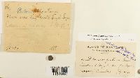 Philonotis fontana (Hedw.) Brid. 41084[1151002]J.H. Sandberg s.n.1891-07-00 United States, Minnesota, Floodwood Bay, N. Shore of L. Superior |
MIN:Bryophytes | 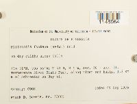 Philonotis fontana (Hedw.) Brid. 852030[1148964]Bowers, Frank D. 236051995-09-09 United States, Minnesota, Cook, T 59 N, R 4 W, sec. 30 + sec. 31. Temperence River State Park, along river and falls, 1.2 km N of Schroeder on Hwy 61, 47.516667 -90.933333 |
MIN:Bryophytes | 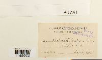 Philonotis fontana (Hedw.) Brid. 41081[1148972]J.M.H. s.n.1895-08-10 United States, Minnesota, Taylor's Falls |
MIN:Bryophytes | 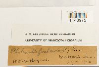 Philonotis fontana (Hedw.) Brid. 647940[1148975]Humphrey, H.B. s.n.1903-08-02 United States, Minnesota, West Duluth |
MIN:Bryophytes | 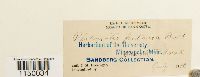 Philonotis fontana (Hedw.) Brid. 41077[1150034]Holzinger, J. M. s.n.1890-07-00 United States, Minnesota |
MIN:Bryophytes | 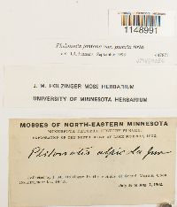 Philonotis fontana var. pumila (Turner) Brid. 647871[1148991]Holzinger, J.M. s.n.1902-07-16 United States, Minnesota, Cook, in the vicinity of Grand Marais, near lat. 48° |
MIN:Bryophytes | 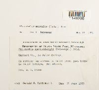 Philonotis marchica (Hedw.) Brid. 610562[1148996]Gerald G Robinson 61959-06-20 United States, Minnesota, Hubbard, Itasca State Park. across La Salle Creek just below La Salle Springs |
MIN:Bryophytes |  Philonotis fontana (Hedw.) Brid. 41076[1148965]Holzinger, J. M. s.n.1890-07-16 United States, Minnesota, Franconia |
MIN:Bryophytes | 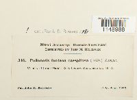 Philonotis fontana var. caespitosa (Jur.) Limpr. 40951[1148988]Holzinger, John M. 316 United States, Minnesota, Cook, Vicinity of Grand Marais. |
MIN:Bryophytes | 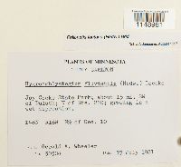 Philonotis fontana (Hedw.) Brid. 856717[1148981]Wheeler, Gerald A. 303041981-07-17 United States, Minnesota, Carlton, Jay Cooke State Park; about 15 mi. SW of Duluth; N of Rte. 210. T48N R16W N1/2 of Sec. 10 |
MIN:Bryophytes | 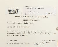 Philonotis fontana (Hedw.) Brid. 852639[1148986]Bowers, Frank D. 23541a1995-09-09 United States, Minnesota, Cook, T59N, R4W, sec. 30 + sec. 31. Temperence River State Park, along river and falls, 1.2 km N of Schroeder on Hwy 61. |
MIN:Bryophytes | 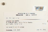 Philonotis Brid. 812935[1148997]J.A. Janssens 87301932-06-11 United States, Minnesota, Washington, Stillwater area: Fairy Falls Canyon, 45.081667 -92.808611, 230m |
MIN:Bryophytes | 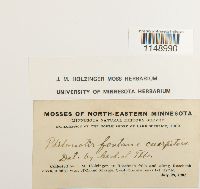 Philonotis fontana var. caespitosa (Jur.) Limpr. 647945[1148990]Holzinger, J. M. s.n.1902-07-28 United States, Minnesota, Cook, at Rosebush falls and along Rosebush creek, 3 miles west of Grand Marais, near lat. 48°N |
MIN:Bryophytes | 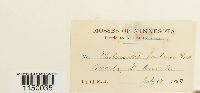 Philonotis fontana (Hedw.) Brid. 41080[1150035]J.M.H. s.n.1890-07-17 United States, Minnesota, Oreola, St. Croix R. |
MIN:Bryophytes |  Philonotis fontana (Hedw.) Brid. 647922[1148974]J.M.H. s.n.1895-08-10 United States, Minnesota, Taylors Falls |
MIN:Bryophytes | 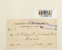 Philonotis fontana (Hedw.) Brid. 41803[1148973]Holzinger, J.M. 241890-06-00 United States, Minnesota |
MIN:Bryophytes | 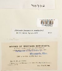 Philonotis fontana var. pumila (Turner) Brid. 40902[1148993]Holzinger, J.M. s.n.1901-06-22 United States, Minnesota, Big Stone, near Ortonville, above 45° N |
MIN:Bryophytes |  Philonotis fontana var. pumila (Turner) Brid. 40903[1148994]Holzinger, J. M. s.n.1901-06-22 United States, Minnesota, Big Stone, Near Ortonville, above lat. 45° N |
MIN:Bryophytes | 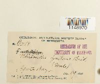 Philonotis fontana (Hedw.) Brid. 41079[1148970]Arthur, J.C. B4981886-07-29 United States, Minnesota, Agate Bay |
MIN:Bryophytes | 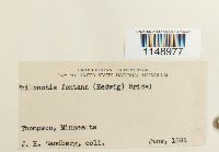 Philonotis fontana (Hedw.) Brid. 536774[1148977]Sandberg, J.H. s.n.1891-06-00 United States, Minnesota |
MIN:Bryophytes | 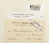 Philonotis fontana (Hedw.) Brid. 41085[1148966]J.M. H. s.n.1890-05-29 United States, Minnesota, Beck's, near Winona |
MIN:Bryophytes |  Philonotis fontana (Hedw.) Brid. 400894[1148967]Newcomb, Eloise s.n.1941-08-19 United States, Minnesota, Clearwater, seepage south of Iron Springs |
MIN:Bryophytes | 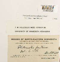 Philonotis fontana (Hedw.) Brid. 647938[1148968]J.M. Holzinger s.n.1902-07-16 United States, Minnesota, Cook, in the vicinity of Grand Marais, near lat. 48° N. |
MIN:Bryophytes | 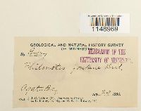 Philonotis fontana (Hedw.) Brid. 41078[1148969]Arthur, J.C. B4971886-07-29 United States, Minnesota, Agate Bay |
MIN:Bryophytes | 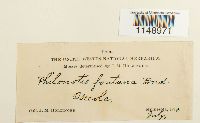 Philonotis fontana (Hedw.) Brid. 536771[1148971]Holzinger, J.M. s.n.1890-07-00 United States, Minnesota |
MIN:Bryophytes | 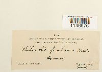 Philonotis fontana (Hedw.) Brid. 536773[1148976]J.M. Holzinger s.n.1890-06-00 United States, Minnesota, Homer |
MIN:Bryophytes |  Philonotis fontana (Hedw.) Brid. 610561[1148978]Olson, W.A 5771960-07-27 United States, Minnesota, Lake, T62N R11W SE1/4 NE1/4 Sec 28, near where Minn. hwy 1 crosses the south branch of the Kawishiwi River |
MIN:Bryophytes |  Philonotis fontana (Hedw.) Brid. 856755[1148982]Wheeler, Gerald A. 301801981-07-14 United States, Minnesota, Lake, Palisade Head; about 1.5 mi. SW of Baptism River State Park on Rte. 61. T56N R7W Sec. 22 |
MIN:Bryophytes |  Philonotis fontana (Hedw.) Brid. 853380[1148983]Bowers, Frank D. s.n.1994-08-29 United States, Minnesota, Lake, T 61N R 11 W, sec. 14, Keely Creek RNA, Superior National Forest, Just west of Hwy 1, South of Keely Creek, ca. 17 km SE of Ely, 47.633333 -91.7 |
MIN:Bryophytes |  Philonotis fontana (Hedw.) Brid. 853381[1148984]F. Bowers 223881994-08-29 United States, Minnesota, Lake, Keely Creek RNA, Superior National Forest, just west of Hwy 1, South of Keely Creek, ca. 17 km SE of Ely, T61N R11 W sec. 14; 47.633333 -91.7; 47.633333 -91.7, 47.633333 -91.7 |
MIN:Bryophytes | 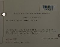 Philonotis fontana (Hedw.) Brid. 853382[1148985]Bowers, Frank D. 223891994-08-29 United States, Minnesota, Lake, T 61N, R 11 W, sec. 14, Keely Creek RNA, Superior National Forest, Just west of Hwy 1, South of Keely Creek, ca. 17 km SE of Ely, 47.633333 -91.7 |
MIN:Bryophytes | 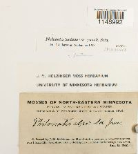 Philonotis fontana var. pumila (Turner) Brid. 647872[1148992]J.M. Holzinger s.n.1902-08-15 United States, Minnesota, On Hat Point, a peninsula projecting southward from Mt. Josephine , into Lake Superior, near Grand Portage |
MIN:Bryophytes |  Philonotis fontana var. pumila (Turner) Brid. 647870[1148995]Holzinger, J.M. s.n.1901-06-22 United States, Minnesota, Big stone, near Ortonville, above lat. 45ºN |
1
Page 1, records 1-36 of 36
Google Map
Google Maps is a web mapping service provided by Google that features a map that users can pan (by dragging the mouse) and zoom (by using the mouse wheel). Collection points are displayed as colored markers that when clicked on, displays the full information for that collection. When multiple species are queried (separated by semi-colons), different colored markers denote each individual species.