University of Minnesota
http://www.umn.edu/
612-625-5000
http://www.umn.edu/
612-625-5000
Minnesota Biodiversity Atlas
Bell Museum
Dataset: All Collections
Taxa: Calliergon giganteum (Hypnum giganteum, Calliergon giganteum f. crassicostatum, Calliergon giganteum f. decurrens, Calliergon giganteum var. cyclophyllotum, Calliergon giganteum var. dendroides, Calliergon giganteum var. fluitans, Calliergon giganteum var. hystricosum, Calliergon giganteum var. immersum, Calliergon giganteum var. labradorense, Calliergon giganteum var. pennatum, Calliergon giganteum var. tenue, Hypnum giganteum var. labradorense, Hypnum giganteum var. fluitans), Calliergon giganteum var. brevifolium, Calliergon giganteum var. tenuis
Search Criteria: Bell Museum bryophytes; Minnesota; excluding cultivated/captive occurrences
1
Page 1, records 1-35 of 35
Bell Museum bryophytes | |
 MIN:Bryophytes | 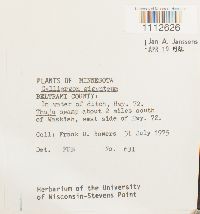 Calliergon giganteum (Schimp.) Kindb. 676999[1112626]Frank D. Bowers 6311975-07-31 United States, Minnesota, Beltrami, Thuja swamp about 2 miles south of Waskish, west side of Hwy. 72 |
MIN:Bryophytes | 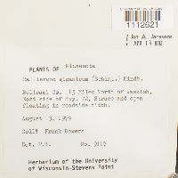 Calliergon giganteum (Schimp.) Kindb. 734181[1112621]Frank Bowers 91171979-08-03 United States, Minnesota, Beltrami, 15 miles North of Waskish, East side of Hwy. 72., 48.363854 -94.551594 |
MIN:Bryophytes | 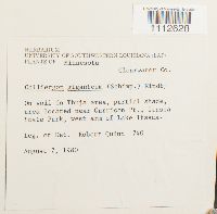 Calliergon giganteum (Schimp.) Kindb. 733551[1112628]Quinn, Robert 7401980-08-07 United States, Minnesota, Clearwater, area located near Garrison Pt, Itasca State Park, west arm of Lake Itasca. |
MIN:Bryophytes | 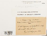 Calliergon giganteum (Schimp.) Kindb. 637046[1112614]J.M. Holzinger 4001895-00-00 United States, Minnesota, Lamoille cave, 44.000269 -91.473139 |
MIN:Bryophytes |  Calliergon giganteum (Schimp.) Kindb. 347834[1112613] 81938-08-00 United States, Minnesota, Cook, Brule R. |
MIN:Bryophytes |  Calliergon giganteum (Schimp.) Kindb. 638681[1112728]M.F. Buell 18241938-08-16 United States, Minnesota, Clearwater, Itasca Park, near Garrison Point |
MIN:Bryophytes |  Calliergon giganteum (Schimp.) Kindb. 865236[1112639]Michael R. Smith 5611997-08-19 United States, Minnesota, Saint Louis, North of Ash River Trail. UMT: 509161E 5360957N |
MIN:Bryophytes |  Calliergon giganteum (Schimp.) Kindb. 865207[1112642]Michael R. Smith 7201998-07-25 United States, Minnesota, Irwin Bay, Voyageurs National Park. UTM 502363E 5362126N Zone 15 NAD 83 |
MIN:Bryophytes | 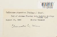 Calliergon giganteum (Schimp.) Kindb. 400943[1112630]Eloise Newcomb s.n.1941-08-12 United States, Minnesota, Clearwater, LaSalle Springs, Itaska Park |
MIN:Bryophytes | 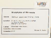 Calliergon giganteum (Schimp.) Kindb. 865213[1112637]Michael R. Smith 7931998-09-06 United States, Minnesota, Saint Louis, Voyageurs National park, Ash River Trail North, 48.4075 -92.885556 |
MIN:Bryophytes | 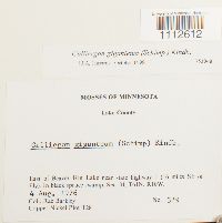 Calliergon giganteum (Schimp.) Kindb. 753948[1112612]Barkley, Rae 3291976-08-04 United States, Minnesota, Lake, East of Beaver Hut Lake near state highway I (16 miles SE of Ely). Copper-Nickel Plot T28. |
MIN:Bryophytes | 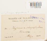 Calliergon giganteum (Schimp.) Kindb. 36724[1112615]J.M.H. s.n.1894-05-00 United States, Minnesota, Winona |
MIN:Bryophytes | 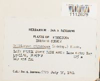 Calliergon giganteum (Schimp.) Kindb. 748717[1112629]Jan A. Janssens 57201981-07-30 United States, Minnesota, Hubbard, LAKE ITASCA STATE PARK AREA: Lace Alice Bog, 47.233333 -94.95, 425m |
MIN:Bryophytes |  Calliergon giganteum (Schimp.) Kindb. 734172[1112620]Frank Bowers 53401977-07-09 United States, Minnesota, Clearwater, Lake Itasca, State Park Black Spruce across from UMBS entrance |
MIN:Bryophytes | 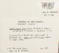 Calliergon giganteum (Schimp.) Kindb. 731103[1112627]F. Bowers 5311975-07-31 United States, Minnesota, Beltrami, 2 miles S of Washkish, on W side of Highway 72. |
MIN:Bryophytes | 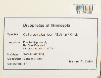 Calliergon giganteum (Schimp.) Kindb. 865211[1112636]Michael R. Smith 8121998-09-08 United States, Minnesota, Koochiching, Rat Root Peatland, 48.49917 -93.19833 |
MIN:Bryophytes | 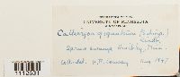 Calliergon giganteum (Schimp.) Kindb. 401146[1112631]Conway, V.A. s.n.1947-08-00 United States, Minnesota, Hinckley |
MIN:Bryophytes | 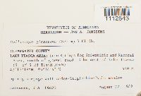 Calliergon giganteum (Schimp.) Kindb. 812861[1112643]J.A. Janssens 196201989-08-22 United States, Minnesota, Clearwater, LAKE ITASCA AREA: Iron Springs Bog Scientific and Natural Area. North of gravel road, 3 km west of Lake Itasca (S_ of S 28), 47.255 -95.245278 |
MIN:Bryophytes | 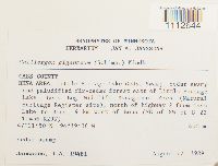 Calliergon giganteum (Schimp.) Kindb. 812882[1112644]J.A. Janssens 194811989-08-17 United States, Minnesota, Cass, BENA AREA: Little Portage Lake Cedar Swamp, east of Little Portage Lake, Bena Bog Wildlife Management Area (Natural Heritage Register site), north of highway 2 from Cass Lake to Bena, 9 km west of Bena (NE of SW), 47.36389 -94.32722, 400m |
MIN:Bryophytes | 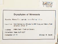 Calliergon giganteum (Schimp.) Kindb. 865246[1112638]Michael R. Smith 5701997-08-27 United States, Minnesota, Saint Louis, Tom Cod Bay SE, MN Voyageurs National Park, 48.4775 -93.136944 |
MIN:Bryophytes | 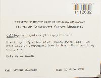 Calliergon giganteum (Schimp.) Kindb. 610382[1112632]Arthur Blickle s.n.1960-06-20 United States, Minnesota, Clearwater, Buell Bog. 2 1/2 miles NW of Itasca State Park. |
MIN:Bryophytes | 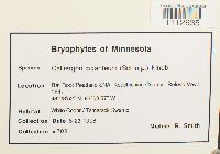 Calliergon giganteum (Schimp.) Kindb. 865218[1112635]Michael R. Smith 7051998-06-23 United States, Minnesota, Koochiching, Rat Root Peatland SNA, Releve Voya 184, 48.481111 -93.149167 |
MIN:Bryophytes | 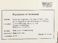 Calliergon giganteum (Schimp.) Kindb. 865227[1112640]Michael R. Smith 7301998-08-23 United States, Minnesota, Ash River Trail North. Releve Voya 189. Voyageurs National Park., 48.39139 -92.90861 |
MIN:Bryophytes | 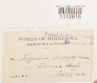 Calliergon giganteum (Schimp.) Kindb. 36725[1112616]J.M. Holzinger s.n.1894-09-14 United States, Minnesota, Winona bluffs |
MIN:Bryophytes | 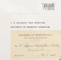 Calliergon giganteum (Schimp.) Kindb. 645219[1112618]J.M.H. 651894-05-09 United States, Minnesota, Bear Creek |
MIN:Bryophytes | 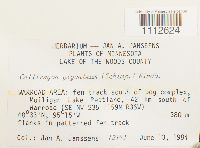 Calliergon giganteum (Schimp.) Kindb. 809580[1112624]Jan A. Janssens 123431984-06-13 United States, Minnesota, Lake Of The Woods, WARROAD AREA: Mulligan Lake Peatland, 42 km south of Warroad (SE NW), 48.55 -95.25, 380m |
MIN:Bryophytes |  Calliergon giganteum (Schimp.) Kindb. 645218[1112617]J.M. Holzinger 961894-08-00 United States, Minnesota, Laneboro |
MIN:Bryophytes |  Calliergon giganteum (Schimp.) Kindb. 645233[1112619]J.M. Holzinger s.n.1897-06-08 United States, Minnesota, on Fall Lake, near the foot of Kawasatchong Falls, seven miles north of Ely |
MIN:Bryophytes | 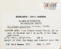 Calliergon giganteum (Schimp.) Kindb. 748710[1112622]Jan A. Janssens 89151982-07-07 United States, Minnesota, Koochiching, WASKISH AREA: Pine Island State Forest, 14 km east of Waskish and 2 km north of the Tamarack River, 48.201111 -94.323611, 365m |
MIN:Bryophytes |  Calliergon giganteum (Schimp.) Kindb. 809361[1112623]Jan A. Janssens 120341984-06-11 United States, Minnesota, Clearwater, LAKE ITASCA AREA: 'Iron Springs Bog' on Hwy 200, 2.4 km east of intersection with Co.Rd. 2, northwestern flank of Sucker Creek (southern half), 47.28333 -95.23333, 450m |
MIN:Bryophytes | 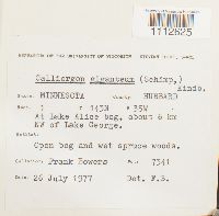 Calliergon giganteum (Schimp.) Kindb. 734152[1112625]Frank Bowers 73411977-07-26 United States, Minnesota, Hubbard, At Lake Alice bog, about 6 km NW of Lake George., 47.232797 -95.067171 |
MIN:Bryophytes | 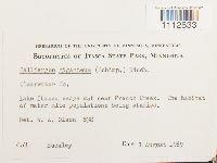 Calliergon giganteum (Schimp.) Kindb. 610626[1112633]Buckley 8381969-08-01 United States, Minnesota, Clearwater, Lake Itasca sedge mat near French Creek, 47.226412 -95.195014 |
MIN:Bryophytes | 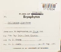 Calliergon giganteum (Schimp.) Kindb. 624376[1112634]Sharp, A.J. s.n.1971-08-22 United States, Minnesota, Cass, Pike Bay Lake |
MIN:Bryophytes | 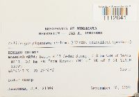 Calliergon giganteum (Schimp.) Kindb. 812774[1112641]J.A. Janssens 213841990-09-18 United States, Minnesota, Roseau, WARROAD AREA: Bemis Hill Cedar Swamp, 0.8 km NWN of Bemis Hill, 30 km SE from Roseau (NE of SE), 48.7175 -95.46778, 355m |
MIN:Bryophytes | Calliergon giganteum (Schimp.) Kindb. 976496[1403296]Kerstin O. Griffin 61e1966-06-00 United States, Minnesota, Koochiching, Red Lake Bog |
1
Page 1, records 1-35 of 35
Google Map
Google Maps is a web mapping service provided by Google that features a map that users can pan (by dragging the mouse) and zoom (by using the mouse wheel). Collection points are displayed as colored markers that when clicked on, displays the full information for that collection. When multiple species are queried (separated by semi-colons), different colored markers denote each individual species.