University of Minnesota
http://www.umn.edu/
612-625-5000
http://www.umn.edu/
612-625-5000
Minnesota Biodiversity Atlas
Bell Museum
Dataset: All Collections
Taxa: Calliergonella cuspidata (Calliergon cuspidatum, Calliergonella conardii, Hypnum cuspidatum, Calliergon cuspidata var. pungens, Calliergon cuspidatum f. acuteramosum, Calliergon cuspidatum f. turgescens, Calliergon cuspidatum var. brevifolium, Calliergon cuspidatum var. umbrosum, Calliergonella cuspidata var. pungens, Calliergonella cuspidata var. umbrosus, Calliergon cuspidatum var. sindelarii), Calliergonella cuspidata var. mollis
Search Criteria: Bell Museum bryophytes; Minnesota; excluding cultivated/captive occurrences
1
Page 1, records 1-24 of 24
Bell Museum bryophytes | |
 MIN:Bryophytes | 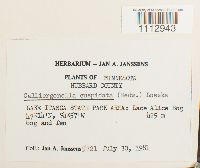 Calliergonella cuspidata (Hedw.) Loeske 748720[1112943]Jan A. Janssens 57211981-07-30 United States, Minnesota, Hubbard, LAKE ITASCA STATE PARK AREA: Lace Alice Bog, 47.233333 -94.95, 425m |
MIN:Bryophytes | 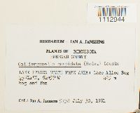 Calliergonella cuspidata (Hedw.) Loeske 748941[1112944]Jan A. Janssens 57381931-07-30 United States, Minnesota, Hubbard, LAKE ITASCA STATE PARK AREA: Lace Alice Bog, 47.233333 -94.95, 425m |
MIN:Bryophytes | 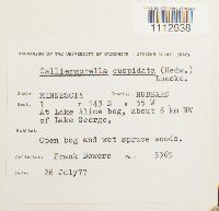 Calliergonella cuspidata (Hedw.) Loeske 734178[1112938]Frank Bowers 53651977-07-26 United States, Minnesota, Hubbard, At Lake Alice bog, about 6 km NW of Lake George, 47.232797 -95.067171 |
MIN:Bryophytes | 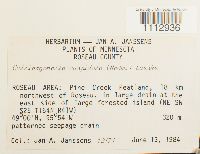 Calliergonella cuspidata (Hedw.) Loeske 809341[1112936]Jan A. Janssens 121711984-06-13 United States, Minnesota, Roseau, Roseau Area: Pine Creek Peatland, 18 km northwest of Roseau, in large drain at the east side of large forested island (NE SW S25 T164N R41W), 49 -95.9, 320m |
MIN:Bryophytes | 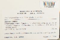 Calliergonella cuspidata (Hedw.) Loeske 812809[1112931]J.A. Janssens 203661990-08-07 United States, Minnesota, Roseau, STRATHCONA AREA: Homolka, beach-ridge complex south of country road 6, 13 km east of Strathcona (NW of. ), 48.56528 -95.98889, 365m |
MIN:Bryophytes | 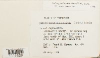 Calliergonella cuspidata (Hedw.) Loeske 677662[1112929]Frank D. Bowers 8581975-08-24 United States, Minnesota, Clearwater, In bog at Iron Bridge (Iron Springs) just north of Hwy. 200, about 1 mi W of Lake Itasca P.O. |
MIN:Bryophytes |  Calliergonella cuspidata (Hedw.) Loeske 876423[1112930]Gerald A. Wheeler 200541999-06-13 United States, Minnesota, Carver, Ca. 1.2 mi. W of Watertown on Rte. 25, W of road. SE1/4 NW1/4. (Watertown 6) |
MIN:Bryophytes | 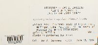 Calliergonella cuspidata (Hedw.) Loeske 809589[1112937]Jan A. Janssens 123391984-06-13 United States, Minnesota, Lake of the Woods, Warroad Area: Mulligan Lake Peatland, 42 km S of Warroad. TRS: T.159N, R.36W, Sec. 35. SE NW of Sec. 35, 48.55 -95.25, 380m |
MIN:Bryophytes | 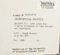 Calliergonella cuspidata (Hedw.) Loeske 748980[1112945]Frank Bowers s.n.1979-07-20 United States, Minnesota, Hubbard, Lake Alive Bog, 3 miles northwest of Lake George. |
MIN:Bryophytes | 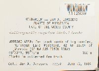 Calliergonella cuspidata (Hedw.) Loeske 809590[1112939]Joannes A Janssens 123381984-06-13 United States, Minnesota, Lake Of The Woods, Mulligan Lake Peatland, 42 km south of Warroad (SE NW. ), 48.55 -95.25, 380m |
MIN:Bryophytes | 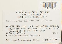 Calliergonella cuspidata (Hedw.) Loeske 809562[1112942]Joannes A Janssens 123361984-06-13 United States, Minnesota, Lake Of The Woods, WARROAD AREA: Mulligan Lake Peatland, 42 km south of Warroad (SE NW or Sec. 25. ), 48.55 -95.25, 380m |
MIN:Bryophytes | 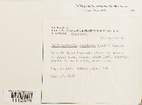 Calliergonella cuspidata (Hedw.) Loeske 733550[1112928]Quinn, Robert 7901980-07-27 United States, Minnesota, Clearwater, Along the shores of Squaw Lake, Itasca State Park |
MIN:Bryophytes | 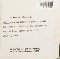 Calliergonella cuspidata (Hedw.) Loeske 733549[1112932]Quinn, Robert 3791979-07-20 United States, Minnesota, Hubbard, Lake Alice Bog, 47.232797 -95.067171 |
MIN:Bryophytes | 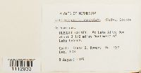 Calliergonella cuspidata (Hedw.) Loeske 677675[1112933]Frank D. Bowers 9321975-08-08 United States, Minnesota, Hubbard, At Lake Alive Bog about 3 1/2 miles northwest of Lake George |
MIN:Bryophytes | 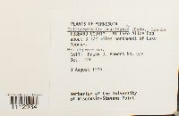 Calliergonella cuspidata (Hedw.) Loeske 676986[1112934]Frank D. Bowers 9481975-08-08 United States, Minnesota, Hubbard, At Lake Alice Bog about 3 1/2 miles NW of Lake George, 47.232797 -95.067171 |
MIN:Bryophytes | 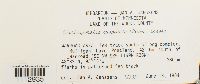 Calliergonella cuspidata (Hedw.) Loeske 809579[1112935]Jan A. Janssens 123351984-06-13 United States, Minnesota, Lake of the Woods, WARROAD AREA: fen track south of bog complex, Mulligan Lake Peatland, 42 km south of Warroad (SE NW of Sec. 25. ), 48.55 -95.25, 380m |
MIN:Bryophytes |  Calliergonella cuspidata (Hedw.) Loeske 809591[1112940]Joannes A Janssens 123441984-06-13 United States, Minnesota, Lake Of The Woods, WARROAD AREA: fen track south of bog complex, Mulligan Lake Peatland, 42 km south of Warroad (SE NW of Sec. 35. ), 48.55 -95.25, 380m |
MIN:Bryophytes |  Calliergonella cuspidata (Hedw.) Loeske 749346[1112941]Frank Bowers 4651978-10-22 United States, Minnesota, Beltrami, Spruce Island with white cedar and Phragmites border. |
MIN:Bryophytes |  Calliergonella cuspidata (Hedw.) Loeske 749347[1112946]Frank Bowers 6521978-10-22 United States, Minnesota, Beltrami, Spruce Island with white cedar and Phragmites border |
MIN:Bryophytes | 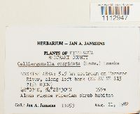 Calliergonella cuspidata (Hedw.) Loeske 748709[1112947]Jan A. Janssens 110531982-08-21 United States, Minnesota, Beltrami, Waskish Area: 5.9 km upstream on Tamarac River, along left bank (SW SW NE of Sec. 15), 48.15 -94.466667, 359m |
MIN:Bryophytes |  Calliergonella cuspidata (Hedw.) Loeske 749348[1112948]Frank Bowers 474-b1978-10-22 United States, Minnesota, Beltrami, Spruce Island with white cedar and Phragmites border. Also open fen water tract. |
MIN:Bryophytes | Calliergonella cuspidata (Hedw.) Loeske 976505[1403305]Kerstin O. Griffin 60d1966-06-00 United States, Minnesota, Koochiching, Red Lake Bog |
MIN:Bryophytes | Calliergonella cuspidata (Hedw.) Loeske 976504[1403304]Kerstin O. Griffin 60a1966-06-00 United States, Minnesota, Koochiching, Red Lake Bog |
MIN:Bryophytes | Calliergonella cuspidata (Hedw.) Loeske 976503[1403303]Kerstin O. Griffin 55d1966-06-00 United States, Minnesota, Koochiching, Red Lake Bog |
1
Page 1, records 1-24 of 24
Google Map
Google Maps is a web mapping service provided by Google that features a map that users can pan (by dragging the mouse) and zoom (by using the mouse wheel). Collection points are displayed as colored markers that when clicked on, displays the full information for that collection. When multiple species are queried (separated by semi-colons), different colored markers denote each individual species.