University of Minnesota
http://www.umn.edu/
612-625-5000
http://www.umn.edu/
612-625-5000
Minnesota Biodiversity Atlas
Bell Museum
Dataset: All Collections
Taxa: Campylium polygamum (Amblystegium polygamum, Hypnum tibetanum, Campylium polygamum var. fluitans, Campylium polygamum var. minus), Campylium polygamum var. stagnatum, Campylium polygamum var. submersum (Hypnum polygamum var. submersum), Campylium polygamum var. fallaciosum, Campylium polygamum var. subsecundum
Search Criteria: Bell Museum bryophytes; Minnesota; excluding cultivated/captive occurrences
1
Page 1, records 1-7 of 7
Bell Museum bryophytes | |
 MIN:Bryophytes | 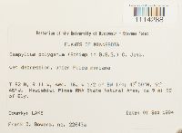 Campylium polygamum (Schimp.) C.E.O. Jensen 853501[1114288]Frank D. Bowers 22643a1994-09-01 United States, Minnesota, Lake, Kawishiwi Pines RNA State Natural Area, ca 9 mi SE of Ely. W 1/2 of SW 1/4, 47.83333 -91.75 |
MIN:Bryophytes | 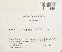 Campylium polygamum (Schimp.) C.E.O. Jensen 753944[1114286]Barkley, Rae 3351976-08-04 United States, Minnesota, Lake, East of Beaver Hut Lake near state highway 1(16 miles SE of Ely). In black spruce swamp, Sec, 31, T61N, R10W. Copper-Nickel Plot T28 |
MIN:Bryophytes | 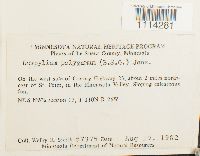 Campylium polygamum (Schimp.) C.E.O. Jensen 809464[1114281]Smith, Welby R. 73751982-08-19 United States, Minnesota, Le Sueur, On the west side of County Highway 23, about 2 miles northeast of St. Peter, in the Minnesota Valley. NE 1/4 NW1/4 section 11, T 110N R 26W |
MIN:Bryophytes | 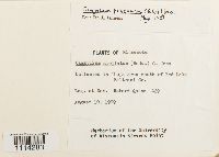 Campylium polygamum (Schimp.) C.E.O. Jensen 733546[1114283]Quinn, Robert 4291979-08-10 United States, Minnesota, Beltrami, In Thuja area south of Red Lake |
MIN:Bryophytes | 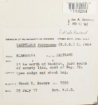 Campylium polygamum (Schimp.) C.E.O. Jensen 734161[1114284]Frank D. Bowers 79501977-07-29 United States, Minnesota, Beltrami, 21 km N of Waskish, just south of county line, east of Hwy. 72 |
MIN:Bryophytes | 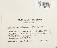 Campylium polygamum (Schimp.) C.E.O. Jensen 735378[1114285]Barkley, Rae 3741976-08-05 United States, Minnesota, Lake, Near Robin Creek River, 18 miles ENE of Babbitt |
MIN:Bryophytes | Campylium polygamum (Schimp.) C.E.O. Jensen 976506[1403306]Kerstin O. Griffin 48-08 a1966-06-00 United States, Minnesota, Koochiching |
1
Page 1, records 1-7 of 7
Google Map
Google Maps is a web mapping service provided by Google that features a map that users can pan (by dragging the mouse) and zoom (by using the mouse wheel). Collection points are displayed as colored markers that when clicked on, displays the full information for that collection. When multiple species are queried (separated by semi-colons), different colored markers denote each individual species.