University of Minnesota
http://www.umn.edu/
612-625-5000
http://www.umn.edu/
612-625-5000
Minnesota Biodiversity Atlas
Bell Museum
Dataset: All Collections
Taxa: Dichodontium pellucidum (Dichodontium subflavescens, Dicranum pellucidum, Dichodontium pellucidum subsp. fagimontanum, Dichodontium pellucidum var. fagimontanum, Dichodontium pellucidum var. flavescens, Dichodontium pellucidum subsp. flavescens), Dichodontium pellucidum var. kodiakanum, Dichodontium pellucidum var. serratum, Dichodontium pellucidum var. yezoense, Dichodontium pellucidum var. americanum
Search Criteria: Bell Museum bryophytes; Minnesota; excluding cultivated/captive occurrences
1
Page 1, records 1-6 of 6
Bell Museum bryophytes | |
 MIN:Bryophytes | 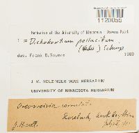 Dichodontium pellucidum (Hedw.) Schimp. 647559[1120055]J. H. n.s.1902-07-28 United States, Minnesota, Cook |
MIN:Bryophytes | 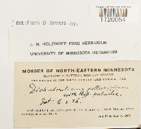 Dichodontium pellucidum (Hedw.) Schimp. 641291[1120054]J.M. Holzinger s.n.1902-07-16 United States, Minnesota, Cook, In the vicinity of Grand Marais |
MIN:Bryophytes | 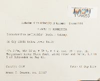 Dichodontium pellucidum (Hedw.) Schimp. 853196[1120053]Frank D. Bowers 235571995-09-09 United States, Minnesota, Cook, sec. 30 + sec. 31. Temperence River State Park, 1.2 km N of Schroeder on Hwy 61, 47.516667 -90.933333 |
MIN:Bryophytes | 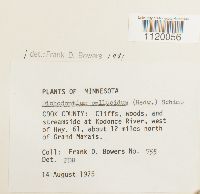 Dichodontium pellucidum (Hedw.) Schimp. 677706[1120056]Frank D. Bowers 7551975-08-14 United States, Minnesota, Cook, at Kodonce River, west of Hwy. 61, about 12 miles north of Grand Marais. |
MIN:Bryophytes |  Dichodontium pellucidum (Hedw.) Schimp. [1298235]Thomas D. Trana 2397 United States, Minnesota, Cook, near shore of L. Superior |
MIN:Bryophytes |  32153[1120084]Williams, R.S. 3271896-05-04 United States, Minnesota, Columbia Falls, 48.37 -114.17 |
1
Page 1, records 1-6 of 6
Google Map
Google Maps is a web mapping service provided by Google that features a map that users can pan (by dragging the mouse) and zoom (by using the mouse wheel). Collection points are displayed as colored markers that when clicked on, displays the full information for that collection. When multiple species are queried (separated by semi-colons), different colored markers denote each individual species.