University of Minnesota
http://www.umn.edu/
612-625-5000
http://www.umn.edu/
612-625-5000
Minnesota Biodiversity Atlas
Bell Museum
Dataset: All Collections
Taxa: Hypnum imponens (Hypnum cupressiforme var. imponens)
Search Criteria: Bell Museum bryophytes; Minnesota; excluding cultivated/captive occurrences
1
Page 1, records 1-12 of 12
Bell Museum bryophytes | |
 MIN:Bryophytes | 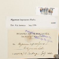 Hypnum imponens Hedw. 36949[1135172]Sandberg, J.H. s.n.1891-07-00 United States, Minnesota, Pine, Pokegama Lake |
MIN:Bryophytes | 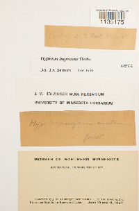 Hypnum imponens Hedw. 645332[1135175]Holzinger, J.M. s.n.1897-06-10 United States, Minnesota, Pipestone, near Camp 11, at the lower end of Pipestone Rapids on Basswood Lake |
MIN:Bryophytes | 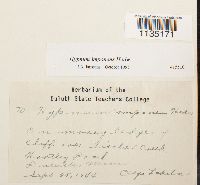 Hypnum imponens Hedw. 415510[1135171]Lakela, O. 701944-09-25 United States, Minnesota, Saint louis, Tischer Creek, Hartley Road. Duluth |
MIN:Bryophytes | 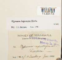 Hypnum imponens Hedw. 36948[1135173]Sandberg, J.H. s.n.1891-06-00 United States, Minnesota, Thompson |
MIN:Bryophytes | 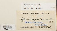 Hypnum imponens Hedw. 36950[1135174]Holzinger, J.M. s.n.1897-06-10 United States, Minnesota, Saint louis, at the lower end of Pipestone Rapids, on Basswood Lake |
MIN:Bryophytes | 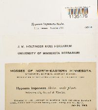 Hypnum imponens Hedw. 645648[1135176]Holzinger, J.M. s.n.1902-07-28 United States, Minnesota, Cook, at Rosebush falls and along Rosebush creek, 3 miles west of Grand Marais, near lat. 48°N |
MIN:Bryophytes | 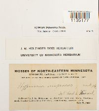 Hypnum imponens Hedw. 645649[1135177]Holzinger, J.M. s.n.1902-07-28 United States, Minnesota, Cook, along Rosebush Creek, 3 miles W of Grand Marais. At Rosebush Falls |
MIN:Bryophytes | 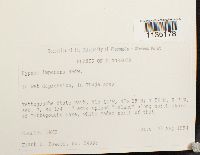 Hypnum imponens Hedw. 853351[1135178]Bowers, F.D. 240331994-09-02 United States, Minnesota, Lake, Tettegouche State Park, T56N R7W S7 SE1/4. Along N shore of Tettegouche Lake, 47.316667 -91.266667 |
MIN:Bryophytes | 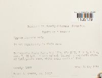 Hypnum imponens Hedw. 853338[1135179]Bowers, F.D. 240171994-09-02 United States, Minnesota, Lake, Tettegouche State Park, N shore of Tettegouche Lake. T56N R7W S7 SE1/4 |
MIN:Bryophytes | 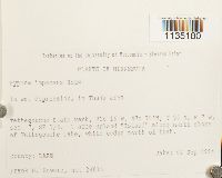 Hypnum imponens Hedw. 853340[1135180]Bowers, Frank D. 240161994-09-02 United States, Minnesota, Lake, Tettegouche State Park, 7 acre upland "Island" along N shore of Tettegouche Lake, white cedar north of that. SE1/4 of Sec. 7; SE 1/4, 47.316667 -91.266667 |
MIN:Bryophytes | 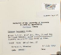 Hypnum imponens Hedw. 856904[1135181]Wheeler, G.A. 306331982-07-17 United States, Minnesota, Carlton, About 1.5 miles E of junction of Route 23 and Soo Railroad tracks. T47N R16W S23 S1/2 |
MIN:Bryophytes | 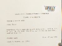 Hypnum imponens Hedw. 852509[1135182]Bowers, F.D. 230621994-09-17 United States, Minnesota, Lake, Heartbreak Creek cRNA. Ca 8 km NNE of Schroeder, west of Road 343; T59N R5W S14, 47.583333 -90.916667 |
1
Page 1, records 1-12 of 12
Google Map
Google Maps is a web mapping service provided by Google that features a map that users can pan (by dragging the mouse) and zoom (by using the mouse wheel). Collection points are displayed as colored markers that when clicked on, displays the full information for that collection. When multiple species are queried (separated by semi-colons), different colored markers denote each individual species.