University of Minnesota
http://www.umn.edu/
612-625-5000
http://www.umn.edu/
612-625-5000
Minnesota Biodiversity Atlas
Bell Museum
Dataset: All Collections
Taxa: Meesia triquetra (Meesia trifaria, Meesia tristicha)
Search Criteria: Bell Museum bryophytes; Minnesota; excluding cultivated/captive occurrences
1
Page 1, records 1-7 of 7
Bell Museum bryophytes | |
 MIN:Bryophytes | 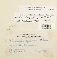 Meesia triquetra (L. ex Jolycl.) Ångström 401147[1140765]Conway, V.M. s.n.1947-08-00 United States, Minnesota, Clearwater, Itasca State park, SE corner, 47.197458 -95.201964 |
MIN:Bryophytes | 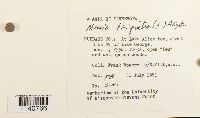 Meesia triquetra (L. ex Jolycl.) Ångström 852011[1140766]Frank D. Bowers s.n.1981-07-31 United States, Minnesota, Hubbard, At lake Alice bog, about 6km NW of Lake George, 47.23187 -95.056789 |
MIN:Bryophytes | 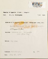 Meesia triquetra (L. ex Jolycl.) Ångström 733510[1140767]Quinn, Robert 3711979-07-20 USA, Minnesota, Hubbard, Lake Alice Bog, 47.2258 -95.062038 |
MIN:Bryophytes | 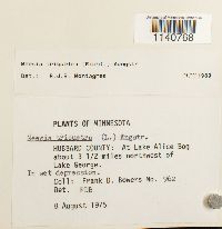 Meesia triquetra (L. ex Jolycl.) Ångström 677693[1140768]Frank D Bowers 9621975-08-08 United States, Minnesota, Hubbard, At Lake Alice Bog about 3&1/2 mi. NW of Lake George, 47.236325 -95.046353 |
MIN:Bryophytes | 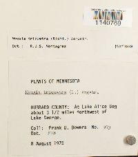 Meesia triquetra (L. ex Jolycl.) Ångström 676991[1140769]Frank D Bowers 9731975-08-08 United States, Minnesota, Hubbard, At Lake Alice Bog ca. 3 1/2 miles NW of Lake George, 47.236325 -95.046353 |
MIN:Bryophytes |  Meesia triquetra (L. ex Jolycl.) Ångström 753887[1140770]Barkley, Rae 4701976-08-05 United States, Minnesota, Saint louis, east end of Snort Lake, 7 mi SE of Babbitt, 47.680441 -91.806543 |
MIN:Bryophytes | 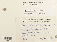 Meesia triquetra (L. ex Jolycl.) Ångström 604899[1140771]H Sjörs s.n1966-06-19 USA, Minnesota, Beltrami, Upper Red Lake Wetlands, Western part, 48.186381 -94.995819 |
1
Page 1, records 1-7 of 7
Google Map
Google Maps is a web mapping service provided by Google that features a map that users can pan (by dragging the mouse) and zoom (by using the mouse wheel). Collection points are displayed as colored markers that when clicked on, displays the full information for that collection. When multiple species are queried (separated by semi-colons), different colored markers denote each individual species.