University of Minnesota
http://www.umn.edu/
612-625-5000
http://www.umn.edu/
612-625-5000
Minnesota Biodiversity Atlas
Bell Museum
Dataset: All Collections
Taxa: Neckera pennata (Neckera oligocarpa, Neckera hymenodonta, Neckera pennata var. oligocarpa, Neckera pennata var. tenera), Neckera pennata var. pennata, Neckera pennata subsp. cephalonica (Neckera pennata var. cephalonica)
Search Criteria: Bell Museum bryophytes; Minnesota; excluding cultivated/captive occurrences
1
Page 1, records 1-73 of 73
Bell Museum bryophytes | |
 MIN:Bryophytes | 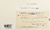 Neckera pennata Hedw. 39994[1143155]J. C. Arthur A351886-07-19 United States, Minnesota, Saint louis, Vermillion Lake |
MIN:Bryophytes |  Neckera pennata Hedw. 853125[1143184]Frank D. Bowers 238841994-09-17 United States, Minnesota, Cook, Lutsen State Natural Area ca 3km NE of Jct 36 & 61 (Hwy 61) NE of Eagle Mt ski area SW corner, 47.75 -90.733333 |
MIN:Bryophytes | 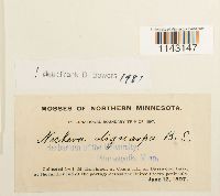 Neckera pennata Hedw. 39999[1143147]Holzinger, J. M. s.n.1897-06-12 United States, Minnesota, At Camp III, on Basswood Lake, at the farther end of the portage across the United States peninsula |
MIN:Bryophytes | 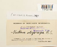 Neckera pennata Hedw. 39998[1143148]Holzinger, J.M. s.n.1897-06-08 United States, Minnesota, Fall Lake, near the foot of Kawasatchong Falls, Seven miles north of Ely, Minn. |
MIN:Bryophytes | 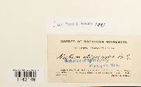 Neckera pennata Hedw. 39996[1143149]Holzinger, J. M. s.n.1897-06-16 United States, Minnesota, At Camp VIII, on a small island named by our party Safety Island (close by South Island), in Lake Saganaga |
MIN:Bryophytes | 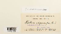 Neckera pennata Hedw. 39997[1143150]Holzinger, J.M. s.n.1897-06-11 United States, Minnesota, On a small point of land at the base of the United states peninsula, Basswood Lake |
MIN:Bryophytes | 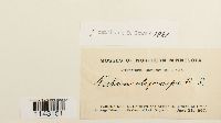 Neckera pennata Hedw. 39995[1143151]Holzinger, J. M. s.n.1897-06-23 United States, Minnesota, On Grand Portage Island, north shore of Lake Superior |
MIN:Bryophytes | 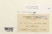 Neckera pennata Hedw. 40018[1143152]Sandberg, J. H. s.n.1891-06-01 United States, Minnesota, Carlton |
MIN:Bryophytes | 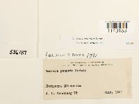 Neckera pennata Hedw. 536789[1143153]Sandberg, J.H. 761891-06-00 United States, Minnesota |
MIN:Bryophytes | 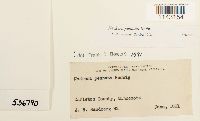 Neckera pennata Hedw. 536790[1143154]Sandberg, J.H. 821891-06-00 United States, Minnesota, Carlton |
MIN:Bryophytes |  Neckera pennata Hedw. 851925[1143156]Bowers, Frank D. 243221994-09-17 United States, Minnesota, Cook, Lutsen State Natural Area, ca 3 km NE of Jet 36 & 61 (Hwy 61) NE of Eagle Mt ski area, T 60 N, R 3 W, sec. 21, NW 1/4 (South Lutsen) -SW corner, 47.75 -90.733333 |
MIN:Bryophytes |  Neckera pennata Hedw. 851879[1143157]Bowers, Frank D. 234391995-09-08 United States, Minnesota, Cook, Look Lake white pine area, Superior Naitonal Forest, T 65 N, R 3 W, sec. 25; Just N of Loon Lake, ca 45 km NW of Grand Marais, north of Hwy 12, 48.05 -90.733333 |
MIN:Bryophytes |  Neckera pennata Hedw. 851873[1143158]Bowers, Frank D. 243441994-09-17 United States, Minnesota, Cook, Lutsen State Natural Area, ca 3 km NE of Jet 36 & 61 (Hwy 61) NE of Eagle Mt ski area. NW 1/4 (South Lutsen) -SW corner; 47.75 -90.733333, 47.75 -90.733333 |
MIN:Bryophytes |  Neckera pennata Hedw. 851726[1143159]Bowers, Frank D. 23050a1994-09-17 United States, Minnesota, Lake, Heartbreak creek cRNA. T 59 N, R 5 W, sec. 14; ca. 8 km NNE of Schroeder, west of Road 343, 47.583333 -90.916667 |
MIN:Bryophytes |  Neckera pennata Hedw. 850783[1143160]Sperling, Calvin R. B861977-09-17 United States, Minnesota, Saint Louis, Near the E. end of Kabetogama Lake, 3.6 miles W. of the Ash River Campground along the Ash R. trail, 48.39167 -92.88333, 347m |
MIN:Bryophytes |  Neckera pennata Hedw. 40024[1143161]MacMillan, C. 151895-09-00 United States, Minnesota, International Boundary Line, Northern Minnesota, Saganaga Lake to South Lake |
MIN:Bryophytes | 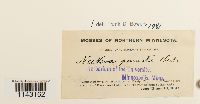 Neckera pennata Hedw. 40025[1143162]Holzinger, J. M. s.n.1897-06-12 United States, Minnesota, at Camp IV, on the Prairie Portage, shore of Basswood Lake, near the rapids from Sucker Lake |
MIN:Bryophytes | 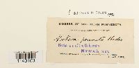 Neckera pennata Hedw. 40026[1143163]Holzinger, J.M. s.n.1897-06-08 United States, Minnesota, Between Ely and Fall Lake |
MIN:Bryophytes | 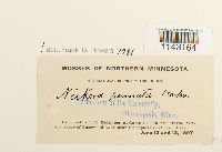 Neckera pennata Hedw. 40027[1143164]Holzinger, J. M. s.n.1897-06-12 United States, Minnesota, at Camp IV, on the Prairie Portage, shore of Basswood Lake, near the rapids from Sucker Lake. |
MIN:Bryophytes | 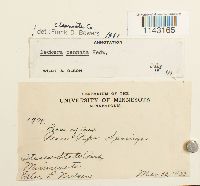 Neckera pennata Hedw. 348896[1143165]Nillsem, L. 19791933-00-30 United States, Minnesota, Itasca State Park. Place Pipe Springs |
MIN:Bryophytes | 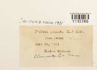 Neckera pennata Hedw. 400898[1143166]Newcomb, Eloise s.n.1941-07-29 United States, Minnesota, Clearwater |
MIN:Bryophytes | 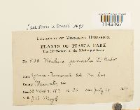 Neckera pennata Hedw. 281253[1143167]Moyle, J.B. 5301931-07-10 United States, Minnesota, Clearwater, Itasca Park. The headwaters of the Mississippi River. SE-NW-10 T.143 R.36 |
MIN:Bryophytes | 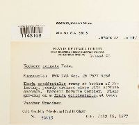 Neckera pennata Hedw. 857491[1143168]Wheeler, Gerald A. 300151977-07-19 United States, Minnesota, swamp at bottom of NW-facing, poorly-drained slope with surface seepage. Marcell Moraine Complex. NW1/4 NW1/4 Sec. 26 T57N R26W |
MIN:Bryophytes |  Neckera pennata Hedw. 852881[1143169]Bowers, Frank D. 236561995-09-21 United States, Minnesota, Cook, T 61 N, R 4 E, Judge Magney State Park, area above Brule River (west), ca 24 km NE of Grand Marais, North of Devil's Kettle, 47.766667 -90.033333 |
MIN:Bryophytes |  Neckera pennata Hedw. 852872[1143170]Bowers, Frank D. 236421995-09-21 United States, Minnesota, Cook, T 61 N, R 4 E, Judge Magney St Park, area above Brule River (west), ca 24 km NE of Grand Marais, North of Devil's Kettle; 47.766667 -90.033333, 47.766667 -90.033333 |
MIN:Bryophytes |  Neckera pennata Hedw. 852874[1143171]Bowers, Frank D. 236471995-09-21 United States, Minnesota, Cook, T 61 N, R 4 E. Judge Magney State Park, area above Brule River (west), ca 24 km NE of Grand Marais, North of Devil's Kettle, 47.766667 -90.033333 |
MIN:Bryophytes |  Neckera pennata Hedw. 852859[1143172]Bowers, Frank D. 236291995-09-21 United States, Minnesota, Cook, T 61 N, R 4 E, Judge Magney St Park, area above Brule River (west), ca 24 km NE of Grand Marais, North of Devil's Kettle; 47.766667 -90.033333, 47.766667 -90.033333 |
MIN:Bryophytes |  Neckera pennata Hedw. 856544[1143173]Bowers, Frank D. 240671994-08-31 United States, Minnesota, Saint Louis, White pine area north of Burnside Lake, ca. 9 km NW of Ely; T 63 N, R 13 W, sec. 2 & 11. |
MIN:Bryophytes |  Neckera pennata Hedw. 852363[1143174]Bowers, Frank D. 241941994-09-22 United States, Minnesota, Cook, Judge Magney State Park area above Brule River (west), T 61 N, R 4 E; ca 24 km NE of Grand Marais, North of Devil's Kettle, 47.766667 -90.033333 |
MIN:Bryophytes |  Neckera pennata Hedw. 852176[1143175]Bowers, Frank D. 227861994-10-02 United States, Minnesota, Lake, Tettegouche State Park, & acre upland "Island" along Northshore of Tettegouche Lake. T 56 N, R 7 W, sec. 7, SE 1/4., 47.316667 -91.266667 |
MIN:Bryophytes |  Neckera pennata Hedw. 852183[1143176]Bowers, Frank D. 234981994-09-08 United States, Minnesota, Cook, Loon Lake, Superior National Forest, T 65 N, R 3 W, sec. 25; ca 45 km NW of Grand Marais. Just N of Loon Lake, North of Hwy 12 |
MIN:Bryophytes |  Neckera pennata Hedw. 853512[1143177]Bowers, Frank D. 22656B1994-09-01 United States, Minnesota, Lake, T 62 N, R 11 W, Sec. 16, W 1/2 of SW 1/4; Kawishiwi Pines RNA State Natural Area; 9 mi SE of Ely, 47.833333 -91.75 |
MIN:Bryophytes |  Neckera pennata Hedw. 853497[1143178]Bowers, Frank D. 24275b1995-09-23 United States, Minnesota, Lake, Crosby-Manitow State Park, T 58 N, R 6W, sec. 28, SW 1/4 & sec. 32, SE 1/4, ca 12 km North of Little Marais, East of Hwy 7. Yellow Birch Area |
MIN:Bryophytes |  Neckera pennata Hedw. 852641[1143179]Bowers, Frank D. 24174a1995-09-21 United States, Minnesota, Cook, 1-10 che Orange Marker Ribbon. Judge Magney State Park, area above Brule River (west) T 61 N, R 4 E; ca 24 km NE of Grand Marais, North of Devil's Kettle, 47.766667 -90.033333 |
MIN:Bryophytes |  Neckera pennata Hedw. 853258[1143180]Bowers, Frank D. 239981995-09-23 United States, Minnesota, Lake, Crosby-Manitow State Park, T 58 N, R 6W, sec. 28, SW 1/4 & sec. 32, SE 1/4, ca 12 km North of Little Marais, East of Hwy 7. Yellow Birch Area |
MIN:Bryophytes |  Neckera pennata Hedw. 853273[1143181]Bowers, Frank D. 228311994-09-02 United States, Minnesota, Lake, Tettegouche State Park T 56 N, R 7 W, sec. 7, SE 1/4; 7 acre upland "Island" along Northshore of Tettegouche Lake |
MIN:Bryophytes |  Neckera pennata Hedw. 852922[1143182]Bowers, Frank D. 229981994-09-17 United States, Minnesota, Lake, Heartbreak Creek cRNA, old growth white cedar. T 59 N, R 5 W, sec. 14; ca. 8 km NNE of Schroeder, west of Road 343 |
MIN:Bryophytes |  Neckera pennata Hedw. 852839[1143183]Bowers, Frank D. 241461995-09-21 United States, Minnesota, Cook, Judge Magney State Park, area above Brule River (west) T 61 N, R 4 E; ca 24 km NE of Grand Marais, North of Devil's Kettle. N upper slope., 47.766667 -90.033333 |
MIN:Bryophytes |  Neckera pennata Hedw. 852267[1143185]Bowers, Frank D. 229441994-09-17 United States, Minnesota, Cook, Lutsen State National Area, T 60 N, R 3 W, sec. 21, ca 3 km NE of Jct. 36 & 61 (Hwy 61). NW1/4 |
MIN:Bryophytes |  Neckera pennata Hedw. 812835[1143186]Janssens, J.A. 198581989-08-28 United States, Minnesota, Cass, BENA AREA: Little Portage Lake, cedar swamp and paludified fir-cedar forest east of Little Portage Lake, Bena Bog Wildlife Management Area (Natural Heritage Register site), north of highway 2 from Cass Lake to Bena, 9 km west of Bena (NE of SW of S 23), 47.36389 -94.32722, 400m |
MIN:Bryophytes |  Neckera pennata Hedw. 852214[1143188]F. Bowers 226571994-09-01 United States, Minnesota, Lake, Kawashiwi Pines RNA Natural Area, ca. 9 mi. SE of Ely. T 62 N, R 11 W, sec. 16, W 1/2 of SW 1/4., 47.833333 -91.75 |
MIN:Bryophytes |  Neckera pennata Hedw. 852180[1143189]Bowers, Frank D. 227911994-09-02 United States, Minnesota, Lake, Tettegouche State Park. T56N, R7W, sec 7, SE 1/4, & acre upland "Island" along Northshore of Tettegouche Lake, 47.316667 -91.266667 |
MIN:Bryophytes |  Neckera pennata Hedw. 857419[1143190]Wheeler, Gerald A. 301311981-07-11 United States, Minnesota, Saint Louis, About 1.5 mi. N of Cotton on Rte. 53; mixed conifer-hardwood forest E of road; near bare of tree in shade. T 54 N R 17 W S1/2 of Sec. 3 |
MIN:Bryophytes |  Neckera pennata Hedw. 852733[1143191]Bowers, Frank D. 239951995-09-23 United States, Minnesota, Lake, Crosby-Manitow State Park, T 58 N, R 6W, sec. 28, SW 1/4 & sec. 32, SE 1/4, ca 12 km North of Little Marais, East of Hwy 7. Yellow Birch Area |
MIN:Bryophytes |  Neckera pennata Hedw. 856632[1143192]Bowers, Frank D. 229171994-09-17 United States, Minnesota, Cook, Lutsen State Natural Area; T 60 N, R 3 W, sec. 21, ca 3 km NE of Jct. 36 & 61 (Hwy 61). NW 1/4. E. Central, 47.75 -90.733333 |
MIN:Bryophytes |  Neckera pennata Hedw. 852749[1143193]Bowers, Frank D. 242621995-09-23 United States, Minnesota, Lake, Crosby-Manitow State Park, T 58 N, R 6 W, sec. 28, SW 1/4 & sec. 32, SE 1/4, ca 12 km North of Little Marais, East of Hwy 7. Yellow Birch Area |
MIN:Bryophytes |  Neckera pennata Hedw. 852122[1143194]Bowers, Frank D. 229281994-09-17 United States, Minnesota, Cook, Lutsen State Natural Area, T 60 N R 3 W, sec. 21, ca 3 km NE f Jct. 36 & 61 (Hwy 61). NW 1/4, 47.75 -90.733333 |
MIN:Bryophytes |  Neckera pennata Hedw. 852437[1143195]Bowers, Frank D. 231061994-09-17 United States, Minnesota, Lake, Wanless Lake White Cedar Swamp, Minn. DNR land, ca. 2.4 km west of cty. Hwy. 7, off logging road, ca. 16 km NW of Schroeder, T 60 N, R 6 W, sec. 19, SW1/4, 47.65 -91.133333 |
MIN:Bryophytes |  Neckera pennata Hedw. 852320[1143196]Bowers, Frank D. 230551994-09-17 United States, Minnesota, Lake, Heartbreak Creek cRNA old growth white cedar. T 59 N, R 5 W, sec. 14; ca 8 km NNE of Schroeder, west of road 343, 47.583333 -90.916667 |
MIN:Bryophytes |  Neckera pennata Hedw. 852321[1143197]Bowers, Frank D. 230561994-09-17 United States, Minnesota, Cook, Heartbreak creek cRNA old growth white cedar. T 59 N, R 5 W, sec. 14; ca. 8 km NNE of Schroeder, west of Road 343, 47.583333 -90.916667 |
MIN:Bryophytes |  Neckera pennata Hedw. 852324[1143198]Bowers, Frank D. 230591994-09-17 United States, Minnesota, Lake, Heartbreak Creek cRNA old growth white cedar. ca 8 km NNE of Schroeder, west of Road 343, 47.583333 -90.916667 |
MIN:Bryophytes |  Neckera pennata Hedw. 852518[1143199]Bowers, Frank D. 243091994-09-17 United States, Minnesota, Lake, Heartbreak creek cRNA old growth white cedar. T 59 N, R 5 W, sec. 14; ca. 8 km NNE of Schroeder, west of Road 343; 47.583333 -90.916667, 47.583333 -90.916667 |
MIN:Bryophytes |  Neckera pennata Hedw. 852301[1143200]Bowers, Frank D. 242091994-09-22 United States, Minnesota, Cook, Judge Magney State Park area above Brule River (west), T 61 N, R 4 E; ca 24 km NE of Grand Marais, North of Devil's Kettle., 47.766667 -90.033333 |
MIN:Bryophytes |  Neckera pennata Hedw. 419970[1143201]Lakela, Olga 118581950-08-27 United States, Minnesota, St. Louis, Shady shorewoods, Crooked Lake, at Curtain Falls |
MIN:Bryophytes |  Neckera pennata Hedw. 583346[1143202]Kellner, Harriet M. 61956-06-20 United States, Minnesota, Lake, Lafayette Bluff, station 1, approximately 16 feet from Lake Superior |
MIN:Bryophytes |  Neckera pennata Hedw. 583542[1143203]Kellner, Harriet M. 271956-08-09 United States, Minnesota, Lake, Shovel Point, station 2 |
MIN:Bryophytes | 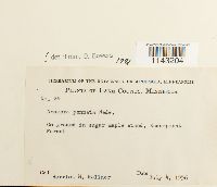 Neckera pennata Hedw. 583544[1143204]Kellner, Harriet M. 241956-07-04 United States, Minnesota, Lake, Encampment Forest |
MIN:Bryophytes | 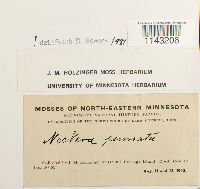 Neckera pennata Hedw. 647740[1143206]Holzinger, J. M. s.n.1902-08-11 United States, Minnesota, Cook, on Grand Portage Island; lat. 48d N |
MIN:Bryophytes | 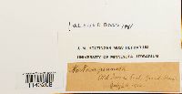 Neckera pennata Hedw. 647743[1143208] s.n.1902-07-26 United States, Minnesota, Old Iron Trail, Grand Marais |
MIN:Bryophytes | 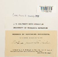 Neckera pennata Hedw. 647745[1143210]Holzinger, J. M. s.n.1897-06-08 United States, Minnesota, On Fall Lake, near the foot of Kawasatchong Falls, 7 mi N of Ely |
MIN:Bryophytes | 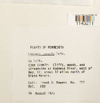 Neckera pennata Hedw. 677002[1143211]Bowers, Frank D. 7771975-08-14 United States, Minnesota, Cook, Cliffs, woods, and streamside at Kodonce River, west of Hwy. 61, about 12 miles north of Grand Marais |
MIN:Bryophytes |  Neckera pennata Hedw. 733501[1143212]Quinn, Robert 4691979-07-28 United States, Minnesota, Clearwater, around UMBS |
MIN:Bryophytes |  Neckera pennata Hedw. 733502[1143213]Quinn, Robert 3411979-07-17 United States, Minnesota, Clearwater, Itasca State Park |
MIN:Bryophytes | 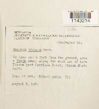 Neckera pennata Hedw. 733503[1143214]Quinn, Robert 7951980-08-07 United States, Minnesota, Clearwater, Along the west arm of Lake Itasca past Carrison Point, Itasca State Park |
MIN:Bryophytes |  Neckera pennata Hedw. 788323[1143215]Trana, Thomas D. 21911977-07-27 United States, Minnesota, St. Louis, Superior National Forest. One mile N of Pfeiffer Lake Campground. 31 miles WSW pf Ely |
MIN:Bryophytes |  Neckera pennata Hedw. 788340[1143216]Trana, Thomas D. 6061975-08-13 United States, Minnesota, Cass, Ottertail Peninsula, Leech Lake. One mile SW of the H. Bacon mailbox along Route 2132. |
MIN:Bryophytes |  Neckera pennata Hedw. 788347[1143217]Trana, Thomas D. 41791978-06-25 United States, Minnesota, Cook, Superior National Forest. Devil's Track River 2.5 miles ENE of Grand MArais. On walls of ravine and talus and flood plain along river. |
MIN:Bryophytes |  Neckera pennata Hedw. 788348[1143218]Trana, Thomas D. 41551978-06-25 United States, Minnesota, Cook, Superior National Forest. Devil's Track River 2.5 miles ENE of Grand Marais. |
MIN:Bryophytes |  Neckera pennata Hedw. 788355[1143219]Trana, Thomas D. 31341977-09-07 United States, Minnesota, Itasca, SW of the junction of MN Highway & Itasca Co. 43, N of Marcell (Sec. 32 T60N, R.26W) |
MIN:Bryophytes |  Neckera pennata Hedw. 788357[1143220]Trana, Thomas D. 31211977-09-07 United States, Minnesota, Itasca, SW of the junction of MN Highway 38 & Itasca Co.43, N of Marcell. Upland ridge with trembling aspen and red and white pine. A few Thuja and a small black ash swamp on side of ridge |
MIN:Bryophytes | Neckera pennata Hedw. 964962[]Glauser, Abby 4322018-07-26 United States, Minnesota, Anoka, Cedar Creek Ecosystem Reserve, Plot CC_THOC_01, 45.40713 -93.199308, 277m |
MIN:Bryophytes | Neckera pennata Hedw. 964940[]Glauser, Abby 7482018-10-04 United States, Minnesota, Lake, Hubachek Wilderness Research Center, Plot HWRC_FRNI_01, 47.954682 -91.746495, 404m |
MIN:Bryophytes | Neckera pennata Hedw. 964994[1403257]Glauser, Abby 9542018-10-19 United States, Minnesota, Carlton, Cloquet Forestry Center, Plot CFC_PIRE_02, 46.69663 -92.52657, 390m |
1
Page 1, records 1-73 of 73
Google Map
Google Maps is a web mapping service provided by Google that features a map that users can pan (by dragging the mouse) and zoom (by using the mouse wheel). Collection points are displayed as colored markers that when clicked on, displays the full information for that collection. When multiple species are queried (separated by semi-colons), different colored markers denote each individual species.