University of Minnesota
http://www.umn.edu/
612-625-5000
http://www.umn.edu/
612-625-5000
Minnesota Biodiversity Atlas
Bell Museum
Dataset: All Collections
Taxa: Tomentypnum nitens (Homalothecium nitens, Camptothecium nitens, Hypnum insigne, Tomentypnum nitens var. insigne, Tomentypnum nitens var. involutum, Homalothecium nitens var. involutum, Camptothecium nitens var. atrichum, Camptothecium nitens var. leucobasis, Camptothecium nitens var. microtheca)
Search Criteria: Bell Museum bryophytes; Minnesota; excluding cultivated/captive occurrences
1
Page 1, records 1-3 of 3
Bell Museum bryophytes | |
 MIN:Bryophytes | 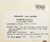 Tomentypnum nitens (Hedw.) Loeske 748803[1171190]Jan A. Janssens 88941982-07-07 United States, Minnesota, Koochiching, Waskish area: Pine Island State Forest, 14km east of Waskish and 2km noreth of the Tamarack River, 48.201111 -94.323611, 365m |
MIN:Bryophytes | Tomentypnum nitens (Hedw.) Loeske 976902[1403373]Kerstin O. Griffin 47-04 c1966-06-00 United States, Minnesota, Koochiching, Red Lake Bog |
MIN:Bryophytes | Tomentypnum nitens (Hedw.) Loeske 976901[1403372]Kerstin O. Griffin 46-06 b1966-06-00 United States, Minnesota, Koochiching, Red Lake Bog |
1
Page 1, records 1-3 of 3
Google Map
Google Maps is a web mapping service provided by Google that features a map that users can pan (by dragging the mouse) and zoom (by using the mouse wheel). Collection points are displayed as colored markers that when clicked on, displays the full information for that collection. When multiple species are queried (separated by semi-colons), different colored markers denote each individual species.