University of Minnesota
http://www.umn.edu/
612-625-5000
http://www.umn.edu/
612-625-5000
Minnesota Biodiversity Atlas
Bell Museum
Dataset: MIN-Plants
Taxa: Lycopodiaceae
Search Criteria: excluding cultivated/captive occurrences
Bell Museum plants | |
 MIN:Plants |  601797[1341440]S.L. Welsh 1966-08-02 United States, Alaska, Mendenhall Lake road, about 12 mi N of Juneau, 58.475328 -134.419722 |
MIN:Plants |  522832[1341441]W.S. Cooper 1906-05-23 United States, Michigan, Mount Pleasant, 43.597808 -84.767514 |
MIN:Plants |  702413[1341442]Sam Brisson 1977-09-01 Canada, Quebec, Eaton, Compton, 1 mi W of Johnville., 45.331985 -71.7718 |
MIN:Plants |  749904[1341443]John & Connie Taylor 1980-07-10 United States, Alaska, about 23 mi N of Juneau. Island of the St. Theresa Chapel, 58.634262 -134.419722 |
MIN:Plants |  749913[1341444]John & Connie Taylor 1981-06-22 United States, Alaska, Revillagigedo Island. near Settler's Cove Campground about 18 mi N of Ketchikan., 55.65 -131.5 |
MIN:Plants |  739059[1341445]C.L. Gilly 1953-05-08 United States, Michigan, Roscommon, T21N R4W S12, 44.225776 -84.74142 |
MIN:Plants |  635101[1341446]John & Connie Taylor 1971-08-25 United States, Colorado, Larimer, just S of Chambers Lake, 40.604524 -105.853376 |
MIN:Plants |  702391[1341447] Canada, Quebec, Sherbrooke, Parc du Mont-Orford. Orford, 45.333333 -72.2 |
MIN:Plants |  702815[1341448]Floyd Bartley 1958-06-18 United States, West Virginia, Pocahontas, 0.5 mi N of Camp Thornwood, 38.565698 -79.737 |
MIN:Plants |  55065[1341657] 1866-07-24 France, Marais des Ponts d'Ouve, 49.506778 -1.300617 |
MIN:Plants |  577140[1341658]Wright, H.E. s.n.1961-08-00 Sweden, Torne, Lapp District, Kebnekaise Area, 67.883333 18.55, 700 - 1200m |
MIN:Plants |  55101[1341659]Bagenholm, G. s.n.1903-07-00 Sweden, Blekuig, Roireby, 62.844321 16.150391 |
MIN:Plants |  55093[1341660]Lomax, A.E. s.n.1890-08-17 Germany, Bavaria, Rain Thal, near Partenkirchen, 47.5 11.116667 |
MIN:Plants |  55091[1341661] 1897-06-00 Germany, Bernh, Lorenz, Zittau, 50.897724 14.807644 |
MIN:Plants |  55097[1341662] 1892-06-00 Switzerland, Funmam, Dirldrfan. Draffaor in Cuyalberg[?], 51.136904 11.078776 |
MIN:Plants |  55094[1341663]Voch s.n.1885-07-27 Germany, Bracken, 47.766954 10.2044 |
MIN:Plants | 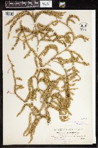 55092[1341664]Dorfler 19021753-00-00 Austria, Austria Superior. Katzenstein mountains near Gmunden, 47.916667 13.8, 1000m |
MIN:Plants | 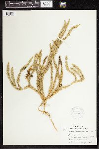 354542[1341665]Lakela, Olga 32171939-08-08 Finland, The former Lakela estates; Kestila, 66.283333 28.85 |
MIN:Plants | 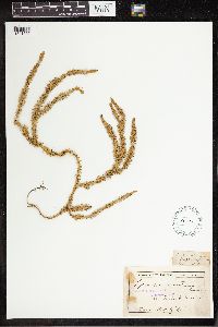 55095[1341666]Trail, J. s.n. United Kingdom, British Islands, 54.65 -6.216667 |
MIN:Plants | 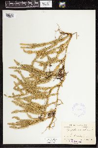 341177[1341667]Brandt, Th. s.n.1924-08-08 Sweden, Machayl[?], 63.389007 15.45052 |
MIN:Plants |  574316[1341668]Jokela, Paavo S. s.n.1961-10-09 Finland, Oulujoki, Sanginjoki, 64.966667 25.666667 |
MIN:Plants |  55096[1341669]Ball, J. s.n.1857-08-04 Switzerland, Cant. Glarus, 47.04057 9.068036, 2 - 2134m |
MIN:Plants |  384395[1341670] 1800-00-00 Europe, 52.47936 20.020833 |
MIN:Plants |  55090[1341671]Enwald, R. s.n.1880-09-08 Finland, Rossia [more info illegible], 64 26 |
MIN:Plants |  260882[1341673]Baenitz, C. s.n.1895-08-17 Poland, Silesia Region, Glatzer Schneeberg; im Holzgraben, 51 18, 750m |
MIN:Plants | []Dutilly, Arthème 1939-09-13 Canada, Quebec, Great Whale River, 55.433333 -78.766667 |
MIN:Plants |  969596[1372086]Dutilly, Artheme s.n.1939-09-13 Canada, Quebec, Great Whale River |
MIN:Plants |  970690[1394179]Otto Gockman 3912020-08-15 United States, Minnesota, Roseau, Sprague Creek Scientific and Natural Area. Approx 14.6km north of Roseau and 3.1km southwest of Roseau Port of Entry, 48.978108 -95.79831 |
MIN:Plants |  972903[1398456]Janssens, J. 76/1251976-08-02 Norway, Morje, Vestfold, 59.533333 9.083333, 100m |
MIN:Plants |  976037[1373590]Smith, Welby R WRS367052020-06-18 United States, Minnesota, Lake Of The Woods, Red Lake State Wildlife Management Area. On the Faunce-Butterfield Forest Road 34 km (21 miles) S-SE of Warroad at a heading of 163 degrees., 48.61327 -95.1771 |
MIN:Plants |  Lycopodium dendroideum Michaux 455755[1339995]Carlson, Bruce 006951998-06-30 United States, Minnesota, Crow Wing, Crow Wing County...Collected 0.5 miles north of Erskine Lake and 1.1 miles ESE of Pine Center. DNR Releve 7623... T43N R28W NWNW16. 043N 28W 16, 46.212512 -93.890495 |
MIN:Plants |  Lycopodium dendroideum Michaux 906515[1341043]Smith, Welby 309612008-07-02 United States, Minnesota, Saint Louis, St. Louis County...About 18 miles E-SE of Gilbert, in Superior National Forest...T57N R14W SW1/4 of SW1/4 of Sec 34;Superior National Forest;057N;14W;34, 47.3744444 -92.1072222 |
MIN:Plants |  Lycopodium dendroideum Michaux 681988[1340408]Clemants, Steven 8541977-08-18 United States, Wisconsin, Oneida, Onieda Co. Wayside rest 8 miles east of Rhinelander, 4.7 miles west of Monico, on U.S. 8. |
MIN:Plants |  Lycopodium dendroideum Michaux 461283[1339980]Gerdes, Lynden 30281998-07-27 United States, Minnesota, Cook, Boundary Waters Canoe Area Wilderness / Superior National Forest. T65N R03E S33SENE. Cook Co.; Superior National Forest, BWCAW. Wetland transition on the south shore of small lake/pond, approx. 0.25 mile north of central John Lake.. T065N R03E S33, 48.071844 -90.06797 |
MIN:Plants |  Lycopodium dendroideum Michaux 508181[1339993]Kaul, Robert B. 23751969-07-15 United States, Minnesota, Lake, near Gegoka Lake, Lake County;Superior National Forest;060N;09W;28, 47.653502 -91.480384 |
MIN:Plants |  Lycopodium dendroideum Michaux 909275[1339991]Smith, Welby 311882008-08-19 United States, Minnesota, Beltrami, Beltrami County...Along the Tamarac River where it enters Upper Red Lake in Waskish...T154N R30W NW1/4 of NW1/4 of Sec 9;Red Lake State Forest;143N;30W;09, 48.1755556 -94.5063889 |
MIN:Plants |  Lycopodium dendroideum Michaux 489387[1311315]Lee, Michael MDL27472000-06-22 United States, Minnesota, Lake, Superior National Forest. Lake County...east of Ninemile Creek and County Road 7 in the Superior National Forest 2-1/2 miles north of Cramer ...T59N R6W SE1/4 of NE1/4 of SW1/4 Sec. 27. 059N 06W 27, 47.566188 -91.075959 |
MIN:Plants |  Lycopodium dendroideum Michaux 915967[1339981]Smith, Welby 313172009-06-28 United States, Minnesota, Cook, Boundary Waters Canoe Area Wilderness / Superior National Forest. Cook County...Boundary Waters Canoe Area Wilderness, Superior National Forest. A peninsula in Long Island Lake... T 64N R 4W NE1/4 of SW1/4 of Sec 24. 064N 04W 24, 48.0091667 -90.7819444 |
MIN:Plants |  Lycopodium dendroideum Michaux 55351[1340391]Wheeler, William 7021900-08-00 United States, Michigan, Keweenaw, Tobin's Harbor, Isle Royale;Isle Royale National Park |
MIN:Plants |  Lycopodium dendroideum Michaux 600372[1340490]Radford, A.; et al. 449491966-07-12 United States, North Carolina, Alleghany, Alleghany County ... near jct. of Blue Ridge Parkway & N.C. 18;Shenandoah National Park |
MIN:Plants |  Lycopodium dendroideum Michaux 55353[1340422]Sandberg, John s.n.1890-06-00 United States, Wisconsin, Barron, Barron;;;;, 45.40139 -91.84889 |
MIN:Plants |  Lycopodium dendroideum Michaux 907690[1339992]Smith, Welby 309882008-07-08 United States, Minnesota, Itasca, Itasca County...Bowstring State Forest, about 6 mi southwest of Squaw Lake (town)...T 147N R 28W SW1/4 of NW1/4 of Sec 4;Chippewa National Forest / Leech Lake Indian Reservation;147N;28W;04, 47.5816667 -94.2425 |
MIN:Plants |  Lycopodium dendroideum Michaux 438495[1339996]Whitfeld, T.J.S. 5762005-05-18 United States, Minnesota, Clearwater, White Earth Indian Reservation. Clearwater County...5-1/2 miles south of Roy Lake; 1/4 mile north of Norris road; 1 mile east of Strawberry Mountain Road...T144N R38W SESE30. 144N 38W 30, 47.260703 -95.541061 |
MIN:Plants |  Lycopodium dendroideum Michaux 261975[1341109]Roberts, Thomas s.n.1925-07-22 United States, Minnesota, Saint Louis, Burntside Lake, Ely;Superior National Forest;063N;13W;00, 47.8833 -92.0333 |
MIN:Plants |  Lycopodium dendroideum Michaux 275810[1341001]Grant, Martin 31171929-08-18 United States, Minnesota, Clearwater, Itasca Park. Clearwater Co. Headwaters. NW-NE 3 T143 R36;Itasca State Park;143N;36W;3, 47.231738 -95.223294 |
MIN:Plants |  Lycopodium dendroideum Michaux 276720[1340000]Huff, N. 61914-07-02 United States, Minnesota, Lake, North Kawaishiwi River, Lake Co.;Superior National Forest;N;;, 47.900775 -91.387134 |
MIN:Plants |  Lycopodium dendroideum Michaux 281402[1341037]Roberts, Thomas s.n.1877-07-00 United States, Minnesota, Saint Louis, Duluth;;N;;, 46.7833 -92.1 |
MIN:Plants | 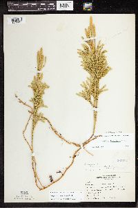 Lycopodium dendroideum Michaux 283102[1341113]Butters, F.K. 4441932-07-16 United States, Minnesota, Cook, N shore Clearwater Lake, Cook Co. T65N, R1E;Boundary Waters Canoe Area Wilderness / Superior National Forest;065N;01E;, 48.087449 -90.322587 |
MIN:Plants | 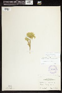 Lycopodium dendroideum Michaux 291856[1341024]Fryklund, P. s.n.1924-08-16 United States, Minnesota, Roseau, Roseau Co.;;N;;, 48.775139 -95.810817 |
MIN:Plants | 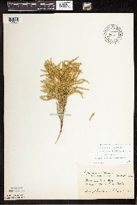 Lycopodium dendroideum Michaux 301028[1341004]Gunderson, Harvey s.n.1940-06-01 United States, Minnesota, Clearwater, Garrison Point Bog, Itasca State Park;Itasca State Park;143N;36W;, 47.197458 -95.201964 |
MIN:Plants | 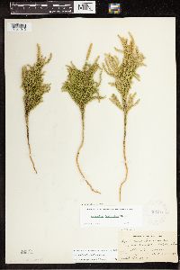 Lycopodium dendroideum Michaux 307210[1341012]Breggie, Jessie s.n.1931-08-20 United States, Minnesota, Grant, Elbow Lake;;;;, 45.990556 -95.975556 |
MIN:Plants |  Lycopodium dendroideum Michaux 333605[1341134]Orr, L. 51929-07-25 United States, Minnesota, Cook, SW1/4, S12, T64, R2W. Cook Co.;Boundary Waters Canoe Area Wilderness / Superior National Forest;064N;02W;12, 48.041154 -90.522854 |
MIN:Plants |  Lycopodium dendroideum Michaux 335518[1341110]Lakela, Olga 18761936-09-20 United States, Minnesota, Saint Louis, About 1/4 of a mi beyond the present bus terminal, Duluth;;N;;, 46.7833 -92.1 |
MIN:Plants |  Lycopodium dendroideum Michaux 346713[1341129]Lakela, Olga 23211937-08-27 United States, Minnesota, Saint Louis, The Lakela farm, Palo, St. Louis Co.;;057N;15W;, 47.415205 -92.259625 |
MIN:Plants |  Lycopodium dendroideum Michaux 347031[1341130]Lakela, Olga 2145b1937-08-06 United States, Minnesota, Saint Louis, On Hwy.35, S of Tower, St. Louis Co.;;N;;, 47.8 -92.2667 |
MIN:Plants |  Lycopodium dendroideum Michaux 350637[1341061]Nielsen, E. 331930-07-21 United States, Minnesota, Cass, back from Norway Beach, Cass Lake;Chippewa National Forest / Leech Lake Indian Reservation;145N;30W;, 47.419288 -94.536519 |
MIN:Plants |  Lycopodium dendroideum Michaux 351580[1341018]Benner, F.R. 5461929-07-29 United States, Minnesota, Cook, 2 1/2 mi N Grand Portage, on old portage trail;Grand Portage National Monument / North Shore;064N;06E;, 47.974454 -89.686529 |
MIN:Plants |  Lycopodium dendroideum Michaux 352412[1341074]Nielsen, E. 131928-07-17 United States, Minnesota, Cass, Cedar Island, Cass Lake;Chippewa National Forest / Leech Lake Indian Reservation;145N;30W;, 47.419288 -94.536519 |
MIN:Plants |  Lycopodium dendroideum Michaux 352685[1341101]Benner, F.R. 6741929-08-23 United States, Minnesota, Cook, Cook Co.; 2 blocks W Hwy.#1 about 1 mi N Mineral Center;Grand Portage Indian Reservation / North Shore;063N;05E;, 47.962139 -89.780647 |
MIN:Plants | 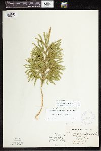 Lycopodium dendroideum Michaux 354293[1341088]Barrows, Vera 1121939-07-14 United States, Minnesota, Saint Louis, Wynne Lake, Biwabik;;N;;, 47.532981 -92.340179 |
MIN:Plants | 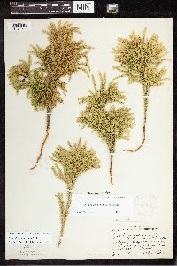 Lycopodium dendroideum Michaux 354883[1341044]Lakela, Olga 26541938-07-30 United States, Minnesota, Saint Louis, On a lake on Hwy. #4 about 5 mi S of Biwabik;;N;;, 47.460607 -92.340179 |
MIN:Plants | 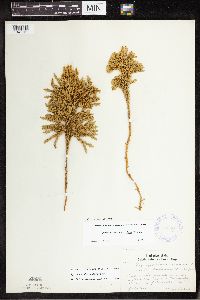 Lycopodium dendroideum Michaux 356404[1341131]Lakela, Olga 31431939-07-15 United States, Minnesota, Lake, Side of the Great Palisade, 65 mi N of Duluth;North Shore / Palisade Head;056N;07W;22, 47.324035 -91.2097 |
MIN:Plants | 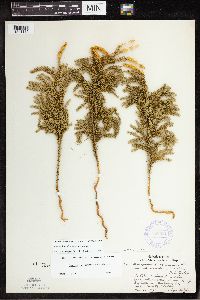 Lycopodium dendroideum Michaux 356531[1341115]Lakela, Olga 34011939-11-30 United States, Minnesota, Lake, On the Great Palisades, 65 mi N of Duluth on Hwy.61, Lake Co.;North Shore / Palisade Head;056N;07W;22, 47.323242 -91.212132 |
MIN:Plants |  Lycopodium dendroideum Michaux 357023[1341031]Rosendahl, C. 68061937-06-28 United States, Minnesota, Winona, N end of Gwinn's Bluff, Winona;Great River Bluffs State Park;106N;05W;, 43.946353 -91.399309 |
MIN:Plants |  Lycopodium dendroideum Michaux 357239[1341132]Nielsen, E. 16241932-09-09 United States, Minnesota, Cook, Pigeon Point, near Grand Portage, Cook Co.;Grand Portage Indian Reservation / North Shore;064N;07E;, 47.997942 -89.538143 |
MIN:Plants |  Lycopodium dendroideum Michaux 357240[1341065]Burns, G. 2141938-07-22 United States, Minnesota, Cook, Cook Co. Cliff N of center of East Pike Lake. T65N R3E.;Boundary Waters Canoe Area Wilderness / Superior National Forest;065N;03E;, 47.726653 -90.386005 |
MIN:Plants |  Lycopodium dendroideum Michaux 357241[1341133]Butters, F.K. 108491939-07-02 United States, Minnesota, Cook, Between Royal Lake and the cliffs S of it. T64N R3E. Cook Co.;Superior National Forest;064N;03E;11, 48.051421 -90.027983 |
MIN:Plants |  Lycopodium dendroideum Michaux 357242[1341137]Butters, F.K. 1321938-07-13 United States, Minnesota, Cook, Small pool S of E end of Mountain Lake.;Boundary Waters Canoe Area Wilderness / Superior National Forest;065N;02E;22, 48.10737 -90.224172 |
MIN:Plants |  Lycopodium dendroideum Michaux 358778[1341125]Butters, F.K. 65651934-09-08 United States, Minnesota, Beltrami, Star Island, Cass Lake, Beltrami Co.;Chippewa National Forest / Leech Lake Indian Reservation;;;, 47.385713 -94.596852 |
MIN:Plants |  Lycopodium dendroideum Michaux 358803[1341056]Bergman, H. 30751914-08-18 United States, Minnesota, Hubbard, Quadrat 15C, Benedict;;143N;32W;35, 47.157195 -94.695017 |
MIN:Plants |  Lycopodium dendroideum Michaux 367166[1341064]Koelnau, L. 1131938-06-24 United States, Minnesota, Cook, Gunflint Trail, E of Poplar Lake, Cook Co.;Superior National Forest;065N;01W;, 48.056001 -90.524269 |
MIN:Plants | 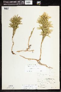 Lycopodium dendroideum Michaux 367305[1341105]Moore, John W. 13434A1940-09-03 United States, Minnesota, Carlton, 8 mi E of Barnum, Carlton Co.;;N;;, 46.502878 -92.520266 |
MIN:Plants | 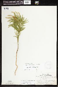 Lycopodium dendroideum Michaux 369172[1341128]Lakela, Olga 45321941-07-23 United States, Minnesota, Saint Louis, At Vermilion River Gorge, St. Louis Co.;Superior National Forest;N;;, 47.891581 -92.366824 |
MIN:Plants | 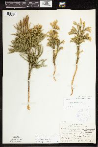 Lycopodium dendroideum Michaux 369763[1341026]Lakela, Olga 44791941-07-09 United States, Minnesota, Lake, On Knife Island in Lake Superior, Knife River, Lake Co.;;N;;, 46.946524 -91.794017 |
MIN:Plants | 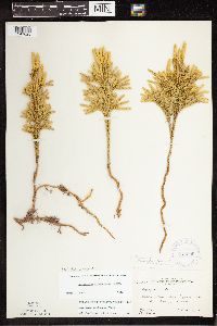 Lycopodium dendroideum Michaux 375599[1341025]Moore, John 151951941-09-22 United States, Minnesota, Lake, Palisade Head, Lake Superior shore, Lake Co.;North Shore / Palisade Head;056N;07W;22, 47.323861 -91.212348 |
MIN:Plants |  Lycopodium dendroideum Michaux 375635[1341050]Moore, John W. 151991941-09-22 United States, Minnesota, Lake, 3 mi W of Illgen City, Lake Co.;;;;, 47.346843 -91.253699 |
MIN:Plants |  Lycopodium dendroideum Michaux 383512[1341114]Moore, John 161081943-09-07 United States, Minnesota, Lake, Palisade Head, Lake Co.;North Shore / Palisade Head;056N;07W;22, 47.323861 -91.212348 |
MIN:Plants |  Lycopodium dendroideum Michaux 385599[1341123]Lakela, Olga 57791944-08-14 United States, Minnesota, Lake, Pancake Island in Lake Superior, between East Beaver Bay and the Palisades. Lake Co.;North Shore;055N;07W;00, 47.2677 -91.282943 |
MIN:Plants |  Lycopodium dendroideum Michaux 387746[1341136]Loula, E. 201938-07-25 United States, Minnesota, Cook, Cook Co. Superior Forest. T62N-R1W-28;Superior National Forest;T062N R01W S28, 47.823738 -90.457648 |
MIN:Plants |  Lycopodium dendroideum Michaux 387747[1341054]Rosendahl, C. s.n.1929-08-15 United States, Minnesota, Cook, Cook Co. Susie Island, T63N R7E;North Shore / Susie Islands, The Nature Conservancy;063N;07E;, 47.987281 -89.581559 |
MIN:Plants |  Lycopodium dendroideum Michaux 387748[1341020]Dahl, A. 341945-06-16 United States, Minnesota, Cook, Cook Co. Near Poplar Lake, T64N R1W 6;Superior National Forest;064N;01W;6, 48.046734 -90.508674 |
MIN:Plants |  Lycopodium dendroideum Michaux 387749[1341141]Lakela, Olga 61881945-09-06 United States, Minnesota, Lake, On Beaver Island in Lake Superior, 2 mi E of Beaver Bay, Lake Co.;North Shore;055N;07W;05, 47.2577 -91.300444 |
MIN:Plants |  Lycopodium dendroideum Michaux 393252[1341017]Ownbey, Gerald 10231948-08-13 United States, Minnesota, Cook, Cook County...NE promentory of Susie Island, Susie Islands near Grand Portage;North Shore / Susie Islands, The Nature Conservancy;064N;07E;, 47.973776 -89.578978 |
MIN:Plants |  Lycopodium dendroideum Michaux 406051[1341011]Lakela, Olga 88741949-07-10 United States, Minnesota, Lake, Back Bay trail, the Hubackek Estate, Basswood Lake, Lake Co.;Boundary Waters Canoe Area Wilderness / Superior National Forest;064N;10W;00, 48.074893 -91.57512 |
MIN:Plants |  Lycopodium dendroideum Michaux 407064[1341087]Lakela, Olga 95011949-08-28 United States, Minnesota, Saint Louis, Near Pakp Point Resort, Lake Kabetogama;Voyageurs National Park;N;;, 48.470908 -93.008801 |
MIN:Plants |  Lycopodium dendroideum Michaux 407163[1341033]Lakela, Olga 97561949-09-12 United States, Minnesota, Saint Louis, Ely-Finland Trail near White Iron Lake, St. Louis Co.;Superior National Forest;N;;, 47.9 -91.8667 |
MIN:Plants |  Lycopodium dendroideum Michaux 412073[1341124]Moore, John 110371939-07-21 United States, Minnesota, Lake of the Woods, Lake of the Woods Co. 1 mi up from the mouth of Pine Creek, Angle Inlet, 3/4 of a mi W of the creek;Northwest Angle;N;;, 49.346587 -95.047469 |
MIN:Plants | 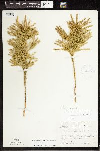 Lycopodium dendroideum Michaux 412770[1341014]Moore, John W. 117971939-08-16 United States, Minnesota, Koochiching, Koochiching Co. About 2 mi south east of Tilson Bay, Rainy Lake;Voyageurs National Park;071N;22W;, 48.607149 -93.198812 |
MIN:Plants | 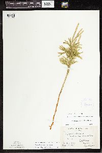 Lycopodium dendroideum Michaux 419285[1341067]Briggs, John De Q. 1201945-08-03 United States, Minnesota, Cook, Cook Co. Sawbill Lake. T62N, R4W.;Boundary Waters Canoe Area Wilderness / Superior National Forest;062N;04W;, 47.88583 -90.87778 |
MIN:Plants | 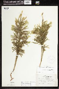 Lycopodium dendroideum Michaux 419770[1341041]Lakela, Olga 117551950-08-25 United States, Minnesota, Saint Louis, Iron Lake, E of Crooked Lake portage, St. Louis Co.;Boundary Waters Canoe Area Wilderness / Superior National Forest;066N;12W;06, 48.203274 -91.857461 |
MIN:Plants | 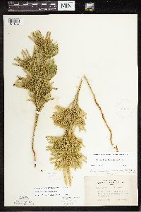 Lycopodium dendroideum Michaux 420569[1341039]Lakela, Olga 97221949-09-01 United States, Minnesota, Saint Louis, Above Ash River, Lake Kabetogama, St. Louis Co.;Voyageurs National Park;N;;, 48.41713 -92.789044 |
MIN:Plants |  Lycopodium dendroideum Michaux 441022[1311319]Myhre, K. 47541994-05-17 United States, Minnesota, Itasca, Itasca Co.; located 6 miles northeast of the town of Inger; T 148N R 26W NW1/4 of SW1/4 of Sec 11;Chippewa National Forest / Leech Lake Indian Reservation;148N;26W;11, 47.649139 -93.942419 |
MIN:Plants |  Lycopodium dendroideum Michaux 442776[1341086]Lakela, Olga 129941951-07-10 United States, Minnesota, Saint Louis, On a point, Namakan Lake at Kettle Falls, St. Louis Co.;Voyageurs National Park;070N;18W;, 48.49944 -92.63889 |
MIN:Plants |  Lycopodium dendroideum Michaux 443236[1341083]Lakela, Olga 137721951-09-13 United States, Minnesota, Saint Louis, Trail to Vermilion river gorge, Crane Lake, St. Louis Co.;Superior National Forest;N;;, 48.2833 -92.4667 |
MIN:Plants |  Lycopodium dendroideum Michaux 444909[1341003]Moore, John W. 195411947-06-12 United States, Minnesota, Itasca, Itasca Co. 10 mi N of Grand Rapids;;N;;, 47.381921 -93.530214 |
MIN:Plants |  Lycopodium dendroideum Michaux 462725[1341091]Lakela, Olga 151391952-07-17 United States, Minnesota, Saint Louis, St. Louis Co. N shore of Kabetogama Lake, 3 mi W Pine Island;Voyageurs National Park;069N;21W;, 48.470908 -93.008801 |
MIN:Plants |  Lycopodium dendroideum Michaux 463062[1341081]Lakela, Olga 159081952-10-13 United States, Minnesota, Saint Louis, St. Louis Co. Beaver Island, Lake Superior, Lake Co.;;055N;07W;, 47.736357 -92.115105 |
MIN:Plants |  Lycopodium dendroideum Michaux 463411[1341094]Lakela, Olga 145521952-07-08 United States, Minnesota, Saint Louis, St. Louis Co. Fox Island, Rainy Lake, most N part of the county.;Voyageurs National Park;071N;21W;, 48.625169 -92.962016 |
MIN:Plants |  Lycopodium dendroideum Michaux 524773[1341135]Benner, F.R. s.n.1938-06-21 United States, Minnesota, Cook, Cross River - Lake Superior;North Shore / Superior National Forest;059N;04W;, 47.726653 -90.386005 |
MIN:Plants | 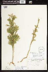 Lycopodium dendroideum Michaux 527327[1341045]Lakela, Olga 176191954-06-24 United States, Minnesota, Saint Louis, St. Louis Co. Gregory Island, Burntside Lake, Ely;Superior National Forest;063N;13W;00, 47.9357 -91.982299 |
Google Map
Google Maps is a web mapping service provided by Google that features a map that users can pan (by dragging the mouse) and zoom (by using the mouse wheel). Collection points are displayed as colored markers that when clicked on, displays the full information for that collection. When multiple species are queried (separated by semi-colons), different colored markers denote each individual species.