University of Minnesota
http://www.umn.edu/
612-625-5000
http://www.umn.edu/
612-625-5000
Minnesota Biodiversity Atlas
Bell Museum
Dataset: MIN-Plants
Taxa: Lycopodiaceae
Search Criteria: excluding cultivated/captive occurrences
Bell Museum plants | |
 MIN:Plants | 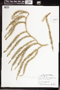 939558[1339715]Smith, Welby R. 316832010-06-16 United States, Minnesota, Koochiching, About a mile west of Margie along County Road 61. NE of NW of section;;153N;26W;10, 48.0898533 -93.9657487 |
MIN:Plants | 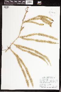 939598[1339761]Smith, Welby R. 317242010-06-17 United States, Minnesota, Itasca, On the south side of Highway 1, about 6 miles west of Effie. NW of NW of section;;062N;27W;26, 47.8379826 -93.7640583 |
MIN:Plants | 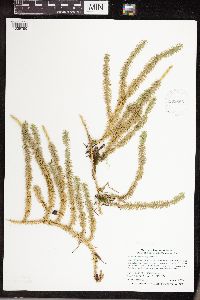 939663[1339790]Smith, Welby R. 321552010-08-29 United States, Minnesota, Cook, About 13 miles northwest of Lutsen. SE of NW of section;;062N;04W;33, 47.8126358 -90.8463763 |
MIN:Plants | 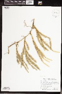 939896[1339725]Smith, Welby R. 307672007-09-05 United States, Minnesota, Saint Louis, About 12 miles N-NW of Virginia. NW of SW of section;;060N;18W;16, 47.680828 -92.6434913 |
MIN:Plants | 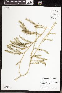 526470[1339712]Smith, Welby R. 307132007-08-24 United States, Minnesota, Koochiching, About 10 miles east of Big Falls. SE of SW of section;Koochiching State Forest;066N;25W;20, 48.1880556 -93.5869444 |
MIN:Plants | 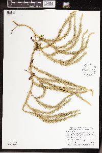 939937[1339647]Smith, Welby R. 307242007-08-24 United States, Minnesota, Koochiching, Along Hwy 65. NE of SW of section;Nett Lake Indian Reservation;065N;23W;16, 48.1163889 -93.3066667 |
MIN:Plants | 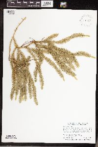 939925[1339724]Smith, Welby R. 307362007-08-24 United States, Minnesota, Itasca, About 13 miles south of Togo. SW of SW of section;George Washington State Forest;060N;22W;31, 47.6342267 -93.1910205 |
MIN:Plants | 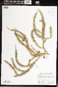 939884[1339713]Smith, Welby R. 307792007-09-05 United States, Minnesota, Saint Louis, About 7 miles northwest of Cook. SE of SW of section;;063N;19W;19, 47.9235943 -92.8217 |
MIN:Plants | 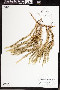 939875[1339711]Smith, Welby R. 307882007-09-05 United States, Minnesota, Saint Louis, About 8 miles W-SW of Cook. SE of SE of section;Sturgeon River State Forest;062N;20W;27, 47.8221814 -92.873805 |
MIN:Plants | 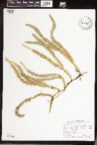 942015[1339723]Smith, Welby R. 323122010-09-07 United States, Minnesota, Saint Louis, Just northeast of the junction of Highways 110 and 16 near Fairbanks. NW of SW of section;;0057;013;33, 47.3766808 -92.0004719 |
MIN:Plants | 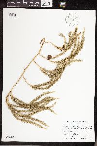 947864[1291999]Smith, Welby R. 304862007-08-02 United States, Minnesota, Cass, Chippewa National Forest, about 5 miles N-NW of Remer. SW of NE of section; T142N R26W sec10, 47.1317422 -93.9511369 |
MIN:Plants | 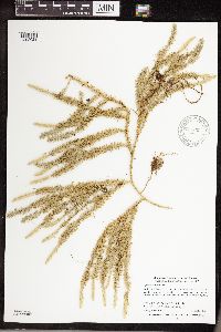 947893[1292028]Smith, Welby R. 305142007-08-02 United States, Minnesota, Aitkin, Hill River State Forest, about 6 miles east of Hill City. SW of SE of section; T052N R25W sec14, 46.9892306 -93.4724094 |
MIN:Plants | 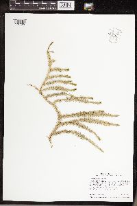 952111[1297209]Smith, Welby R. 349772014-06-24 United States, Minnesota, Saint Louis |
MIN:Plants | 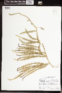 959683[1318001]Gerdes, Lynden B. 73562015-08-05 United States, Minnesota, Koochiching, Koochiching State Forest. Approximately 9.62 miles SW of Littlefork, MN and 0.88 miles east of the Highway 71 and Wisner Trail (FR 239) junction; then north ~ 0.05 miles on winter road., 48.31027778 -93.71194444 |
MIN:Plants | 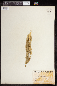 960259[1318736]Friesner, Ray C. 102211936-08-13 United States, Maine, Waldo, bordering Megunticook Lake |
MIN:Plants | 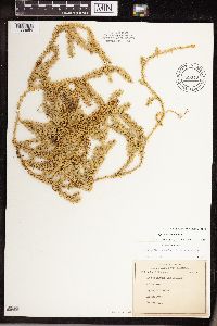 689319[1339654]Ownbey, Gerald B. s.n.1978-00-00 United States, Minnesota |
MIN:Plants | 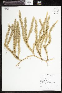 939073[1341253]Mary I. Moore 1966-10-21 Canada, Ontario, Renfrew, Deep RIver, Balmer's Bay Road. E of Wylie, 46.1 -77.5 |
MIN:Plants | 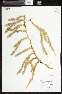 938977[1341254]Mary I. Moore 1966-10-21 Canada, Ontario, Renfrew, Deep RIver, Balmer's Bay Road. E of Wylie; 46.1 -77.5, 46.1 -77.5 |
MIN:Plants | 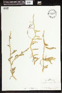 510943[1341255]Frank L. Beals 1944-07-05 United States, Alaska, St. Matthews Island, Bering Sea, 60.42334 -172.764695 |
MIN:Plants | 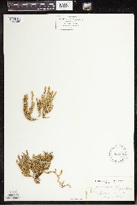 522842[1341256]W.S. Cooper 1903-08-19 United States, Maine, Table land, Mt. Katahadin, 45.908102 -68.934212 |
MIN:Plants | 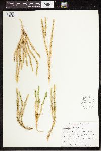 536397[1341257]Garton, C.E. 1955-08-17 Canada, Ontario, Thunder Bay, NW corner of Middlebrun Bay, 3 mi NE of Silver Islet. Sibley Peninsula, 48.364025 -88.770485 |
MIN:Plants | 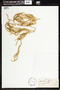 55070[1341258]Waghorne, A.C. 1893-08-14 Canada, Newfoundland and Labrador, 54.333333 -61.749167 |
MIN:Plants | 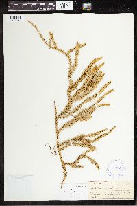 388055[1341259]Newlin Williams 1897-09-02 United States, New Hampshire, Coos, Mount Washington, 44.2667 -71.3, 1585m |
MIN:Plants | 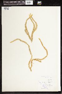 55105[1341260]Fernald, M.L. 1893-08-19 United States, Maine, Aroostook, along the St. John River, St. Francis |
MIN:Plants | 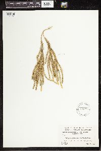 559474[1341261]Hosie, R.C. 1938-08-25 Canada, Ontario, Algoma District near the Magpie River. Vicinity of Michipicoten Harbour, 47.95 -84.916667 |
MIN:Plants | 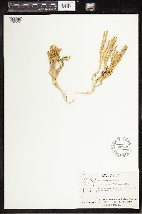 557167[1341262]Moir, D.R. 1953-07-25 Canada, Ontario, 15 miles from the mouth of the Black Duck River, 56.80017 -89.05015 |
MIN:Plants | 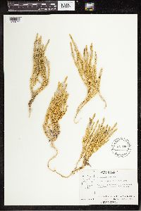 557166[1341263]Moir, D.R. 1953-07-24 Canada, Ontario, 22 miles from the mouth of the Black Duck River, 56.615703 -89.296088 |
MIN:Plants | 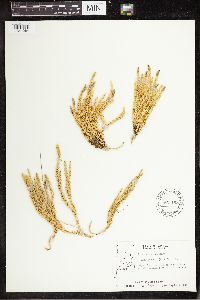 557168[1341264]Moir, D.R. 1957-08-09 Canada, Ontario, Vicinity of Sachigo Lake; near winter road to Sachigo Lake, 53.8 -92.083333 |
MIN:Plants | 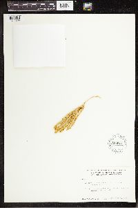 599916[1341265]William S. Cooper 1935-09-04 United States, Alaska, Prince Williams Sound |
MIN:Plants | 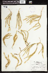 398147[1341266]Harper, Francis 1947-10-20 Canada, Nunavut, Keewatin, Hudson Bay Hill, Red River. 3 mi SW of Simons Lake., 60.80268 -99.812867 |
MIN:Plants | 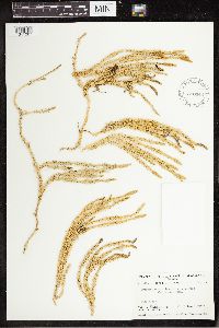 580046[1341267]Raup, H.M. 1939-07-15 Canada, Northwest Territories, Mackenzie, Vicinity of Brintnell Lake, Camp Point, 62.083333 -127.55 |
MIN:Plants | 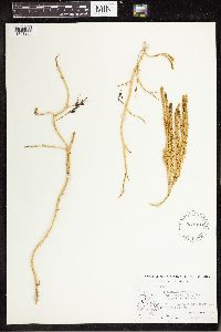 533910[1341268]Abbe, Ernst C. 1939-08-02 Canada, Quebec, East Coast of Hudson Bay. 1/2 mi East of Salmon Fishery Cove |
MIN:Plants | 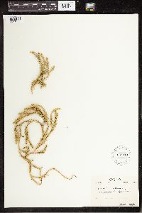 531940[1341269]Oldenburg, Margaret E. 1947-09-09 Canada, Quebec, East Main, James Bay, 45.70357 -81.66486 |
MIN:Plants | 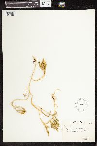 531941[1341270]Oldenburg, Margaret E. 1947-09-09 Canada, Quebec, Fort George, James Bay, 53.833333 -78.993889 |
MIN:Plants | 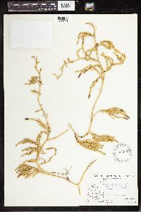 533894[1341271]Abbe, Ernst C. 1939-06-30 Canada, Quebec, East Coast of Hudson Bay. N of the Narrows, Cairn Island, 56.133333 -76.3 |
MIN:Plants | 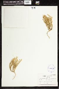 404343[1341272]Sargent, F.H. 1949-07-27 Canada, Quebec, Gaspe, Mount Albert |
MIN:Plants | 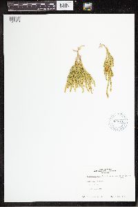 663619[1341273]G.L. Jacobson 1974-08-09 Canada, Newfoundland and Labrador, Webb Bay |
MIN:Plants | 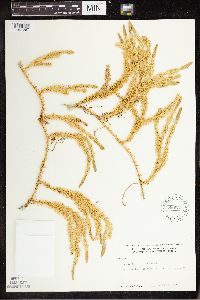 533839[1341287]William S. Cooper 1929-07-21 United States, Alaska, Glacier Bay, Station 21, 58.797845 -136.458473 |
MIN:Plants | 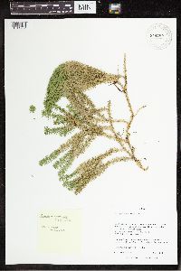 944780[1341292]M. Noe 2014-09-04 United States, Wisconsin, Taylor, Chequamegon National Forest. Along Forest Road 571/Sailor Creek Road 0.5 km S of junction with Lost Lake Road. T32N R1W S6, 45.272397 -90.558959 |
MIN:Plants | 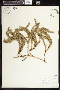 447291[1341293]Robinson S. Abbott 1952-08-12 United States, New York, Tompkins, Slaterville Springs, 42.395628 -76.350491 |
MIN:Plants |  744546[1341294]David. F. Grether 1980-07-26 Canada, British Columbia, N of White Pass along Carcross Highway #2, 59.616667 -135.133333 |
MIN:Plants |  827461[1341295]Grether, David F. 1980-08-05 United States, Alaska, Chugach Mts, Anchorage. Flattop Tundra, 61.218056 -149.900278 |
MIN:Plants |  827516[1341296]Grether, David F. 1980-08-03 United States, Alaska, Along Seward Highway #1, Mt. Alyeska, 60.95 -149.05 |
MIN:Plants |  260890[1341297]E.H. Eames 1908-08-04 Canada, Newfoundland and Labrador, Blow-Me-Down Mountains, 49.152674 -57.963379, 488m |
MIN:Plants | 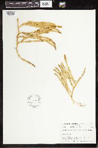 580050[1341298]Raup, H.M. 1939-06-26 Canada, Northwest Territories, Vicinity of Brintnell Lake; E and NE slopes of Red Mt., 62.083333 -127.55, 1066m |
MIN:Plants | 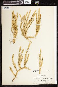 84854[1341299]Holway 1905-07-02 United States, Utah, Moraine Lake, Laggan Alta, 40.588839 -111.637979 |
MIN:Plants | 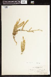 55064[1341300]Holway 1904-08-16 Canada, Alberta, Mount Humph, 54.837656 -115.246094, 1829m |
MIN:Plants | 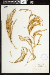 361177[1341301]Ethel H. Looff 1938-05-00 United States, Alaska, Kodiak Island, 57.540467 -153.696675 |
MIN:Plants | 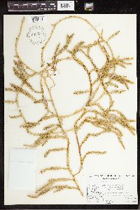 533914[1341302]Abbe, Ernst C. 1939-06-29 Canada, Quebec, East Coast of Hudson Bay, side NW of the narrows, Cairn Island, 56.133333 -76.3 |
MIN:Plants | 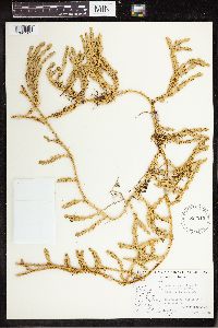 533215[1341303]Abbe, Ernst C. 1939-08-02 Canada, Quebec, East Coast of Hudson Bay, 0.5 mi E of Salmon Fishery Cove, 58.031059 -78.267875 |
MIN:Plants | 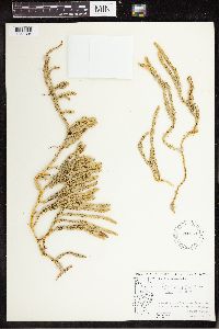 534050[1341304]Abbe, Ernst C. 1939-08-27 Canada, Nunavut, East coast of Hudson Bay, east of Hudson Bay Company buildings. Tukarak Island, 56.25 -78.75 |
MIN:Plants | 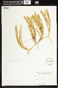 599865[1341307]William S. Cooper 1935-09-05 United States, Alaska, Prince William Sound, Station 28, 60.75 -147 |
MIN:Plants | 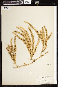 55048[1341308]Briggs, F.P. 1893-10-00 United States, Maine, Orono, 44.883125 -68.671977 |
MIN:Plants | 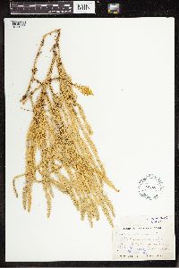 55060[1341309]M.W. Gorman 1894-09-02 United States, Alaska, Shores of Bshur Canal[?], 64.969324 -153.540365 |
MIN:Plants | 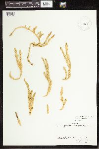 460247[1341312]W.J. Beckenridge 1962-08-20 Canada, Nunavut, Mackenzie, inlet to Conjurer's Bay. Great Bear Lake, 66.151479 -121.274658 |
MIN:Plants | 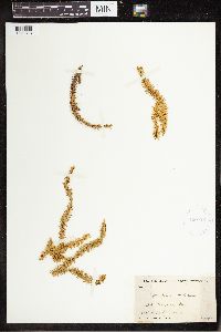 420422[1341313]David Potter 1934-06-24 Canada, Little Mekattina Island, Gulf of the St. Lawrence River, 50.55 -59.333333 |
MIN:Plants |  415797[1341314]W.F. Westerfeld 1941-06-23 United States, Pennsylvania, Sullivan, Davidson Township near Emmons. State Game Lands, 41.307304 -76.438556 |
MIN:Plants |  388051[1341315]Wadmond, S.C. 1898-07-00 United States, Wisconsin, Oneida, Three Lakes, 45.79829 -89.162905 |
MIN:Plants |  388053[1341316]Paul R. Wagner 1937-07-21 United States, Pennsylvania, Schuylkill, North Mahanoy City, S of Girard Manor, 40.812588 -76.141603 |
MIN:Plants |  564988[1341317]Shirley Cotter 1950-06-29 United States, Montana, Lake, Mud Lake, Mission Range, 47.6167 -113.9833 |
MIN:Plants | 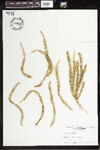 714518[1341318]H.E. Ahles 1979-10-02 United States, Vermont, Windham, West Halifax |
MIN:Plants | 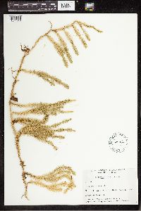 142990[1341319]W.B. Schofield 1950-08-22 Canada, Manitoba, Churchill, Gillam, 56.35 -94.7 |
MIN:Plants | 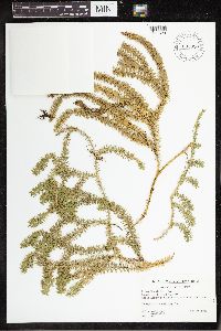 633820[1341320]Walther, A. 1962-08-16 Canada, Quebec, Brome, Brome Mountain, 45.188889 -72.562222, 579 - 594m |
MIN:Plants | 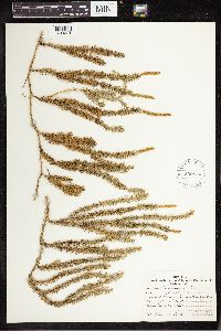 530854[1341321]Rood, Almon N. 1931-09-25 United States, Pennsylvania, Elk, Ridgway, 41.420339 -78.728639 |
MIN:Plants | 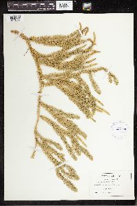 404124[1341322]Sargent, F.H. 1949-08-01 Canada, Quebec, Gaspe, Perce, 48.518233 -64.187745 |
MIN:Plants | 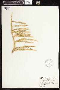 541251[1341323]Raup, H.M. 1932-09-01 Canada, Alberta, Lake Athabaska, Alta. E of Sand Point, 59 -110.5, 213m |
MIN:Plants | 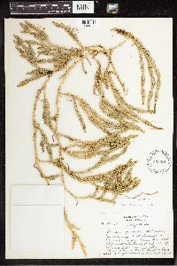 505221[1341324]Eva Beckett 1954-07-25 Canada, Manitoba, 3 mi SE of Churchill, 58.736005 -94.107561 |
MIN:Plants | 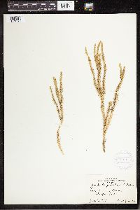 365091[1341325]Don L. Jacobs 1939-07-11 Canada, Ontario, Thunder Bay, Sturgeon Bay, 45.90634 -82.71234 |
MIN:Plants | 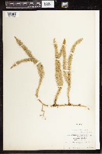 84857[1341326]H. Shaw 1905-06-19 Canada, Selkirk, Howser Lake, 50.383333 -116.95, 762m |
MIN:Plants | 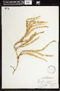 292974[1341327]M.L. Buell 1934-09-16 United States, Montana, SW shore of Lake McGregor, 20 mi W of Kalispell, 48.032096 -114.889807 |
MIN:Plants | 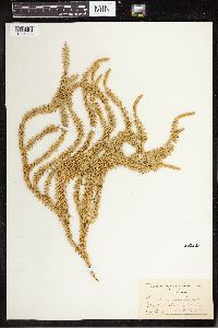 300225[1341328]L.M. Umbach 1903-08-19 United States, Montana, Belton, 47.375521 -110.926346 |
MIN:Plants | 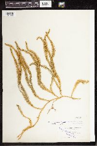 55104[1341329]Fernald, M.L. 1893-07-24 United States, Maine, Aroostook, Along the St. John River, Van Buren, 47.15 -67.9333 |
MIN:Plants | 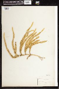 55052[1341330]Briggs, F.P. 1893-10-00 United States, Maine, Orono |
MIN:Plants | 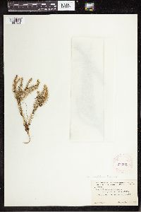 273465[1341331]Wright, A.H. 1919-09-09 United States, New York, Essex, Mt. Marcy trail, 44.112733 -73.923783 |
MIN:Plants | 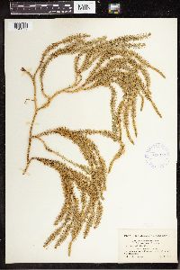 418317[1341332]Fernald, M.L. 1915-07-28 United States, New Hampshire, Mt. Woodstock, 43.977568 -71.68508 |
MIN:Plants | 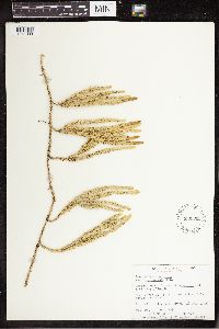 536392[1341333]Garton, C.E. 1955-07-16 Canada, Ontario, Thunder Bay, Middlebrun Island, 3 mi E of Silver Islet, Sibley Peninsula, 48.333315 -88.751356 |
MIN:Plants | 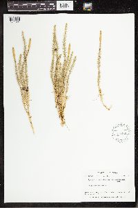 579486[1341334]Raup, H.M. 1944-08-06 United States, Alaska, S side of Tanana River valley, 64.260635 -146.632398 |
MIN:Plants | 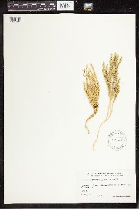 539672[1341335]J.W. Marr 1948-08-11 Canada, Quebec, about 90 mi above the mouth of Leaf River, 58 -72.5 |
MIN:Plants | 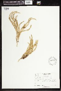 557165[1341336]Moir, D.R. 1951-06-25 Canada, Ontario, Big Trout Lake, 53.75 -90 |
MIN:Plants | 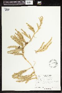 557164[1341337]Moir, D.R. 1951-07-12 Canada, Ontario, R.C. Mission, Sandy Lake, 53.033333 -92.916667 |
MIN:Plants | 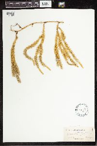 55057[1341338]Briggs, F.P. 1893-10-00 United States, Maine, Orono, 44.883125 -68.671977 |
MIN:Plants | 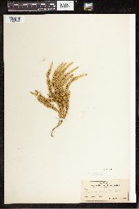 55061[1341339]John W. Harshberger 1904-07-25 United States, Pennsylvania, Pocono Plateau, Moraine, 41.259373 -75.462769 |
MIN:Plants | 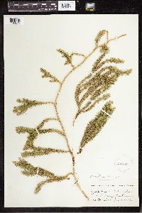 273467[1341340] United States, Vermont, Orange, Corinth, 44.033129 -72.269638 |
MIN:Plants | 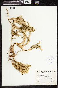 424737[1341341]Marie-Victorin 1940-08-27 Canada, Quebec, Beauce, Saint-Frederic, 46.347712 -70.894237 |
MIN:Plants | 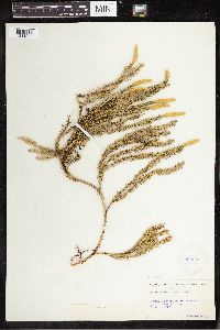 288695[1341342]Stewart H. Burnham 1916-09-07 United States, New York, Lake George Region. Mt. Hope, NW Fort Ann, 43.4833 -73.5333 |
MIN:Plants | 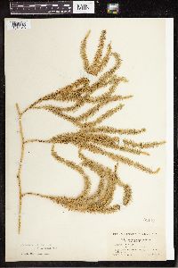 55102[1341343]Fernald, M.L. 1915-07-28 United States, New Hampshire, Mt. Woodstock; 43.977568 -71.68508, 43.977568 -71.68508 |
MIN:Plants | 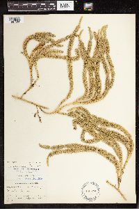 486879[1341344]Churchill, J.R. 1908-07-20 Canada, New Brunswick, Connors, St. John River, 47.2 -68.833333 |
MIN:Plants | 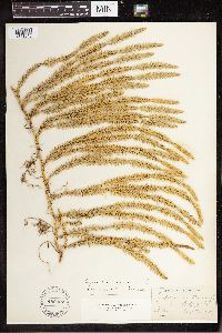 486922[1341345]Walter Deane 1889-08-07 United States, New Hampshire, E of Jaffrey, 42.813973 -72.023136 |
MIN:Plants | 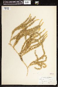 260896[1341346]Fernald, M.L. 1894-09-04 United States, Maine, Piscataquis, Dover, 43.923136 -69.637824 |
MIN:Plants | 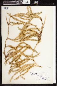 55071[1341347]Fernald, M.L. 1895-07-22 United States, Maine, Piscataquis, Dover, 43.923136 -69.637824 |
MIN:Plants | 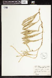 541330[1341348]Raup, H.M. 1932-09-04 Canada, Alberta, N shore of Lake Athabaska, Alta. Sand Point, 59 -110.5, 213m |
MIN:Plants | 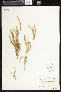 531981[1341349]Oldenburg, Margaret E. 1947-09-09 Canada, Quebec, Fort George, James Bay.; 53.75 -78.833333, 53.75 -78.833333 |
MIN:Plants | 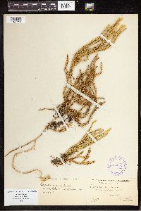 388054[1341350]N.C. Fassett 1932-08-28 United States, Maine, Somerset, Mt. Bigelow, 45.147277 -70.289234 |
MIN:Plants | 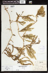 388052[1341351]Wadmond, S.C. 1934-09-08 Canada, Wisconsin, Door, SE corner of Washington Island, 45.347566 -86.874293 |
MIN:Plants | 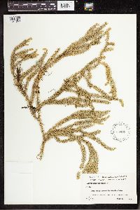 559473[1341353]Hosie, R.C. 1938-07-05 Canada, Ontario, Algoma, Mission Lake, Vicinity of Michipicoten Harbor, 47.95 -84.916667 |
MIN:Plants | 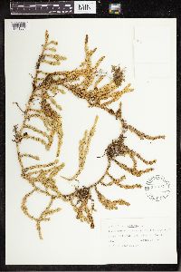 565137[1341354]Shirley Cotter 1951-08-11 Canada, Alberta, Jasper National Park, near Sunwapta Falls on Highway 1, 52.532222 -117.645278 |
MIN:Plants |  530672[1341355]Francis W. Pennell 1937-06-08 United States, Michigan, Schoolcraft, 12 mi W of Manistique, 45.957478 -86.496179 |
MIN:Plants |  531735[1341356]K.S. Snell 1956-09-02 United States, Wisconsin, Forest, Julia Lake. T38N R12E S6, 45.802746 -89.037176 |
MIN:Plants |  528613[1341357]J.M. Gillett 1950-05-27 Canada, Newfoundland and Labrador, Goose Bay, 53.3 -60.416667 |
MIN:Plants |  589257[1341358]L. Jensen 1959-09-04 United States, New York, Delaware, Stamford, 42.405708 -74.617686 |
Google Map
Google Maps is a web mapping service provided by Google that features a map that users can pan (by dragging the mouse) and zoom (by using the mouse wheel). Collection points are displayed as colored markers that when clicked on, displays the full information for that collection. When multiple species are queried (separated by semi-colons), different colored markers denote each individual species.