University of Minnesota
http://www.umn.edu/
612-625-5000
http://www.umn.edu/
612-625-5000
Minnesota Biodiversity Atlas
Bell Museum
Dataset: MIN-Plants
Taxa: Araceae
Search Criteria: excluding cultivated/captive occurrences
Bell Museum plants | |
 MIN:Plants |  Lemna minuta Kunth 84562[1337091]Goodding, Leslie N. 9351902-05-23 United States, Nevada, Lincoln |
MIN:Plants |  Lemna minuta Kunth 236058[1337092]Congdon, J. S. s.n.1882-10-15 United States, California, Mariposa |
MIN:Plants |  Lemna minuta Kunth 84557[1337093]Hansen, George 4821894-00-00 United States, California, Placer, New York Canyon Falls, 39.0833 -120.8333, 457m |
MIN:Plants |  Lemna minuta Kunth 255277[1337094]Goodding, Leslie N. 9351902-05-23 United States, Nevada, Lincoln |
MIN:Plants | 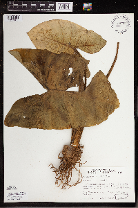 Xanthosoma sagittifolium (L.) Schott 775254[1337805]Lane, C.; Gieschen, R. 1731977-07-12 Puerto Rico, Near Orocovis, off #566 near Rio Bautia.;;;;, 18.203115 -66.412171 |
MIN:Plants | 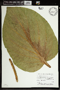 Symplocarpus foetidus (L.) Salisbury ex W. P. C. Barton 914975[1337618]Whitfeld, T.J.S. 6832006-06-14 United States, Minnesota, Hubbard, Hubbard County...1-1/2 miles west of Hwy 71; 3/4 southeast of Hay Creek...UTM (NAD83): E337559 N5210478;;141N;35W;00, 47.02176 -95.10692 |
MIN:Plants | 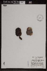 Symplocarpus foetidus (L.) Salisbury ex W. P. C. Barton 471946[1311650]Cholewa, A. 25942006-08-14 United States, Minnesota, Anoka, Cedar Creek National History Area. Anoka County, Cedar Creek Natural History Area, County Road 24 about 2 miles east of highway 65, vicinity of Chickadee Cabin, T34N R23W S27. 034N 23W 27, 45.406779 -93.193727 |
MIN:Plants | 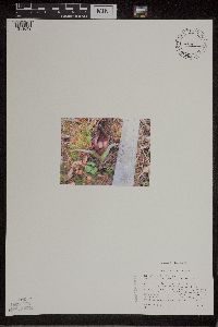 Symplocarpus foetidus (L.) Salisbury ex W. P. C. Barton 493187[1311649]Ritter, Jason s.n.2004-00-00 United States, Minnesota, Saint Louis, St. Louis Co. Near Floodwood.;;;;, 46.958889 -92.7472229 |
MIN:Plants |  Symplocarpus foetidus (L.) Salisbury ex W. P. C. Barton 485601[1337666]Rand, Edward s.n.1890-06-20 United States, Maine, Hancock, Mount Desert Island...Sea Wall Marsh;Acadia National Park;;;, 44.3333 -68.3333 |
MIN:Plants |  Symplocarpus foetidus (L.) Salisbury ex W. P. C. Barton 431798[1311647]Carlson, Bruce 011332001-08-13 United States, Minnesota, Itasca, Itasca County...8 miles NNW of Bovey, 0.5 mile south of Cnty Rd 59, 0.3 miles north of Clearwater Lake. T057N R25W NWSWSW24.. 057N 25W 24, 47.406169 -93.461326 |
MIN:Plants |  Symplocarpus foetidus (L.) Salisbury ex W. P. C. Barton 264244[1337607]Holzinger, John s.n.1887-04-20 United States, Minnesota, Winona, Winona Co.;;N;;, 43.910786 -91.723308 |
MIN:Plants |  Symplocarpus foetidus (L.) Salisbury ex W. P. C. Barton 270621[1337611]Johnson, G. s.n.1987-08-09 United States, Minnesota, Kanabec, T42N R24W NW1/4 of sec.20, Kanabec Co.;;042N;24W;20, 46.108821 -93.399469 |
MIN:Plants |  Symplocarpus foetidus (L.) Salisbury ex W. P. C. Barton 288110[1337609]Erickson, Lawrence s.n.1915-03-00 United States, Minnesota, Hennepin, Minnehaha Creek bottoms.;;N;;, 44.905162 -93.166462 |
MIN:Plants |  Symplocarpus foetidus (L.) Salisbury ex W. P. C. Barton 288217[1337615]Anonymous 31914-04-25 United States, Minnesota, Snelling Reservation [old regional park spanning junction of Minnesota and Mississippi rivers];;028N;23W;, 44.90516 -93.16646 |
MIN:Plants |  Symplocarpus foetidus (L.) Salisbury ex W. P. C. Barton 288501[1337608]Jahnke, E. s.n.1914-05-06 United States, Minnesota, Chippewa, Beltline Bridge.;;;; Montevideo, 44.94897 -95.729982 |
MIN:Plants |  Symplocarpus foetidus (L.) Salisbury ex W. P. C. Barton 288572[1337643]Meck, Carlton s.n.1914-04-14 United States, Minnesota, Hennepin, Minnehaha Glen.;Minnehaha Falls Park;028N;23W;, 44.905162 -93.166462 |
MIN:Plants |  Symplocarpus foetidus (L.) Salisbury ex W. P. C. Barton 360907[1337610]Moyle, J. 35641940-07-25 United States, Minnesota, Lake, On the shores of Knife River.;;N;;, 46.946524 -91.794017 |
MIN:Plants |  Symplocarpus foetidus (L.) Salisbury ex W. P. C. Barton 362652[1337614]Butters, F.; Moore, John 135831940-09-18 United States, Minnesota, Chisago, 3 mi. N of Taylors Falls.;;N;;, 45.445347 -92.652429 |
MIN:Plants |  Symplocarpus foetidus (L.) Salisbury ex W. P. C. Barton 367695[1337644]Moore, John; et al. 125221940-05-18 United States, Minnesota, Fillmore, 7 mi SW of Preston. Fillmore Co.;;102N;11W;, 43.630642 -92.14936 |
MIN:Plants |  Symplocarpus foetidus (L.) Salisbury ex W. P. C. Barton 370153[1337606]Moore, John; et al. 141041941-05-24 United States, Minnesota, Pine, NW1/4 sec.28, Rock Creek Twp, Pine Co.;Chengwatana State Forest;038N;20W;28, 45.751754 -92.847125 |
MIN:Plants |  Symplocarpus foetidus (L.) Salisbury ex W. P. C. Barton 370783[1337632]Moore, John; et al. 137881941-05-03 United States, Minnesota, Washington, NE1/4 Section 21 Stillwater Township, Washingto Co.;;030N;20W;21, 45.071961 -92.812692 |
MIN:Plants |  Symplocarpus foetidus (L.) Salisbury ex W. P. C. Barton 371243[1337635]Moore, John 148811941-07-13 United States, Minnesota, Fillmore, NW1/4, Sec.29, Fountain Twp, Fillmore Co.;Dorer Memorial Hardwood State Forest;103N;11W;29, 43.695364 -92.179153 |
MIN:Plants |  Symplocarpus foetidus (L.) Salisbury ex W. P. C. Barton 441362[1337624]Smith, Welby 128651987-06-09 United States, Minnesota, Washington, Saint Croix National Riverway. Washington Cunty ... In the St. Croix River Valley, about 2 mi S of Marine on St. Croix ... NW1/4 NE1/4 sec.19 T 31N R 19W. 031N 19W 19, 45.1633339 -92.7630539 |
MIN:Plants |  Symplocarpus foetidus (L.) Salisbury ex W. P. C. Barton 441697[1311654]Lee, Michael MDL1251993-05-14 United States, Minnesota, Dakota, Dakota Co.; Macalester College Field Station, River Lake; T 27N R 22W NW1/4 of SW1/4 of sec 23;;027N;22W;23, 44.809161 -93.006793 |
MIN:Plants |  Symplocarpus foetidus (L.) Salisbury ex W. P. C. Barton 443360[1311644]Lee, Michael MDL11771996-05-23 United States, Minnesota, Fillmore, Fillmore Co.; Shattuck Creek valley 2 miles west of Choice; T102N R8W SE1/4 NW1/4 NW1/4 Sec. 8, NE1/4 NW1/4 Sec. 8;Dorer Memorial Hardwood State Forest;102N;08W;8, 43.652328 -91.819713 |
MIN:Plants |  Symplocarpus foetidus (L.) Salisbury ex W. P. C. Barton 446516[1337639]Moore, John; Huff, N. 185351946-06-10 United States, Minnesota, Kanabec, Kanabec Co. 3 mi N of Mora.;;040N;24W;, 45.942918 -93.327854 |
MIN:Plants |  Symplocarpus foetidus (L.) Salisbury ex W. P. C. Barton 455278[1337633]Svang, M. 61958-05-06 United States, Minnesota, Hennepin, Hennepin Co, Fort Snelling Reservation [poss. intended Fort Snelling military reservation & not the old regional park];Fort Snelling Military Reservation;028N;23W;, 44.905162 -93.166462 |
MIN:Plants |  Symplocarpus foetidus (L.) Salisbury ex W. P. C. Barton 456935[1311651]Myhre, K. 34871993-04-26 United States, Minnesota, Pine, Pine Co.; located one half mile west of the St. Croix River; small creek; T 38N R 20W SE1/4 of SE1/4 of SEc 23;Chengwatana State Forest;038N;20W;23, 45.766369 -92.8059 |
MIN:Plants | 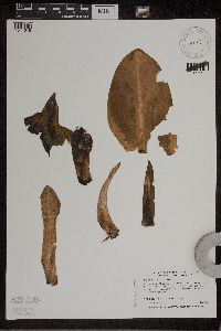 Symplocarpus foetidus (L.) Salisbury ex W. P. C. Barton 458712[1311646]Boe, J. 970603011997-06-03 United States, Minnesota, Aitkin, Aitkin Co.; near County Road 64 NE of Round Lake. In stand of plant list PL97-01; T49N R22W NE1/4 of SE1/4 of Sec 16;Savanna State Forest;049N;22W;16, 46.730736 -93.136824 |
MIN:Plants | 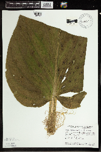 Symplocarpus foetidus (L.) Salisbury ex W. P. C. Barton 459164[1337625]Smith, Welby 130461987-06-18 United States, Minnesota, Pine, Pine Co.; in the St. Croix River Valley, about 7 mi SE of Pine City; NE1/4 NE1/4 sec.21, T38N R20W;;038N;20W;21, 45.7722206 -92.8411102 |
MIN:Plants | 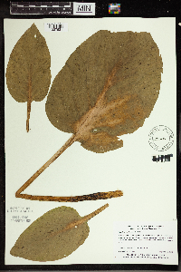 Symplocarpus foetidus (L.) Salisbury ex W. P. C. Barton 475686[1337621]Myhre, K. 9431991-09-06 United States, Minnesota, Aitkin, Aitkin Co.; 4 miles south fo Glen, 5 miles east, 1 mile south; T 45N R 24W NE1/4 of NW1/4 of Sec 29;;045N;24W;29, 46.355106 -93.400047 |
MIN:Plants | 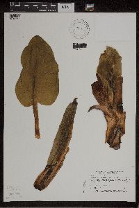 Symplocarpus foetidus (L.) Salisbury ex W. P. C. Barton 514451[1311652]Myhre, K. 35351993-05-06 United States, Minnesota, Pine, Banning State Park. Pine Co.; located less than 1 mi N of the town of Sandstone, in the vicinity of the bat hibernacleum; escarpments of the Pine Co.; located less than 1 mi N of the town of Sandstone, in the vicinity of the bat hibernacleum; escarpments of the Kettle River; T42N R20W NW1/4 of NW1/4 of Sec 10. 042N 20W 10, 46.136086 -92.855561 |
MIN:Plants |  Symplocarpus foetidus (L.) Salisbury ex W. P. C. Barton 520231[1337620]Smith, Welby 129631987-06-16 United States, Minnesota, Washington, Washington County...on the E side of Highway 4, about 1/2 mi NW of Marine on St. Croix; abut 150 feet above the floodplain of the St. Croix River; SW1/4 NE1/4 sec.1, T31N R20W. 031N 20W 1, 45.2061111 -92.7797222 |
MIN:Plants |  Symplocarpus foetidus (L.) Salisbury ex W. P. C. Barton 572797[1337641]Moore, John 254121961-06-08 United States, Minnesota, Houston, Along Beaver Creek, 5 mi. W of Caledonia.;Beaver Creek Valley State Park;102N;07W;, 43.630496 -91.670784 |
MIN:Plants |  Symplocarpus foetidus (L.) Salisbury ex W. P. C. Barton 583998[1337637]Gunderson, R. 3761961-07-03 United States, Minnesota, Washington, St. Croix River 3 mi N of Stillwater;Saint Croix National Riverway;030N;20W;, 45.09983 -92.80583 |
MIN:Plants |  Symplocarpus foetidus (L.) Salisbury ex W. P. C. Barton 586446[1337616]Moore, John 264261963-08-01 United States, Minnesota, Anoka, S of the Norris cabin, Cedar Creek Natural History Area.;Cedar Creek National History Area;034N;23W;, 45.428063 -93.203997 |
MIN:Plants |  Symplocarpus foetidus (L.) Salisbury ex W. P. C. Barton 588237[1337645]Morley, T. 10511964-06-14 United States, Minnesota, Chisago, Chisago Co. T36N R20W Sec.6;Wild River State Park;036N;20W;6, 45.636682 -92.893254 |
MIN:Plants |  Symplocarpus foetidus (L.) Salisbury ex W. P. C. Barton 681120[1337640]Swanson, Steven 24921976-04-00 United States, Minnesota, Houston, Mississippi River (Navigation Pool #8). Houston Co. Site 42.;Upper Mississippi National Wildlife Refuge;N;;, 43.771295 -91.250286 |
MIN:Plants |  Symplocarpus foetidus (L.) Salisbury ex W. P. C. Barton 695858[1337646]Clemants, Steven 11061978-06-09 United States, Minnesota, Chisago, Goose Creek, ca. 3 mi. NE of Harris.;;036N;21W;, 45.600632 -92.960367 |
MIN:Plants |  Symplocarpus foetidus (L.) Salisbury ex W. P. C. Barton 701522[1337638]Johnson, Gary s.n.1977-06-12 United States, Minnesota, Kanabec, S of hwy. 27, 4 mi E of Isle. T42N R20W Sec.20. Kanabec Co.;;042N;24W;20, 46.108821 -93.399469 |
MIN:Plants |  Symplocarpus foetidus (L.) Salisbury ex W. P. C. Barton 708398[1337636]Ownbey, Gerald 64761979-09-13 United States, Minnesota, Washington, Washington County ... T 30 N R 20 W Sec. 14 NW1/4, 1.5-2.0 mi NE of Stillwater ... St. Croix River.;Saint Croix National Riverway;030N;20W;14, 45.090515 -92.777311 |
MIN:Plants |  Symplocarpus foetidus (L.) Salisbury ex W. P. C. Barton 729930[1337604]Converse, C. 6491980-08-29 United States, Minnesota, Pine, Pine co. Kettle River Natural Area: 5.5 mi E of Hinckley. T41N R20W SW1/4 NW1/4 sec.23;Kettle River Scientific Natural Area / Sandstone National Wildlife Refuge;041N;20W;23, 46.018609 -92.835797 |
MIN:Plants |  Symplocarpus foetidus (L.) Salisbury ex W. P. C. Barton 730388[1337603]Phelps, V. 1081980-08-21 United States, Minnesota, Chisago, Goose Creek Natural Area: 5 mi. SE of Rush City.;Wild River State Park;036N;21W;13, 45.607985 -92.908918 |
MIN:Plants |  Symplocarpus foetidus (L.) Salisbury ex W. P. C. Barton 737998[1337623]Monson, Paul 51391981-05-03 United States, Minnesota, Saint Louis, Jean Duluth Road, 6 5/8 mi. N of Duluth city limits (Martin Rd.). W side of the road.;;052N;14W;24, 46.974386 -92.058529 |
MIN:Plants |  Symplocarpus foetidus (L.) Salisbury ex W. P. C. Barton 746286[1337605]Smith, Welby 38221981-05-18 United States, Minnesota, Houston, Houston Co. On the N side of hwy. 16, ca. 2 mi. W of Hokah.;Dorer Memorial Hardwood State Forest;103N;05W;1, 43.753424 -91.382708 |
MIN:Plants |  Symplocarpus foetidus (L.) Salisbury ex W. P. C. Barton 758066[1337627]Smith, Welby 58741982-04-18 United States, Minnesota, Winona, Winona Co. On the S-side of Trout Creek, ca. 1/8 mi. W of its confluence with the Mississippi River.;Upper Mississippi National Wildlife Refuge;106N;05W;7, 43.998558 -91.470475 |
MIN:Plants |  Symplocarpus foetidus (L.) Salisbury ex W. P. C. Barton 774896[1337602]Wheeler, Gerald 83511984-06-19 United States, Minnesota, Fillmore, Fillmore Co. Forestville State Park. On a N-facing wooded ravine, overlooking a small creek.;Forestville State Park;102N;11W;7, 43.652307 -92.199253 |
MIN:Plants | Symplocarpus foetidus (L.) Salisbury ex W. P. C. Barton 774936[1337628]Wheeler, Gerald 81901984-05-10 United States, Minnesota, Houston, Beaver Creek Valley State Park. Near Beaver Creek.;Beaver Creek Valley State Park;102N;06W;8, 43.652273 -91.581116 |
MIN:Plants |  Symplocarpus foetidus (L.) Salisbury ex W. P. C. Barton 774966[1337626]Wheeler, Gerald 61281982-07-10 United States, Minnesota, Winona, Winona Co. Ca. 1 mi. SE of LaMoille on Rte. 61. Adjacent to Big Trout Creek (S side of the creek).;Upper Mississippi National Wildlife Refuge;106N;05W;7, 43.998558 -91.470475 |
MIN:Plants |  Symplocarpus foetidus (L.) Salisbury ex W. P. C. Barton 787200[1337601]Smith, Welby 100011985-03-16 United States, Minnesota, Hennepin, Hennepin Co.; On the S side of 106th St. in Bloomington Central Park. Along Nine-Mile Creek.;;027N;24W;21, 44.811938 -93.298819 |
MIN:Plants |  Symplocarpus foetidus (L.) Salisbury ex W. P. C. Barton 800105[1337630]Johnson, G. s.n.1988-08-03 United States, Minnesota, Crow Wing, N.E.1/4 of N.E.1/4 S.10 T43N R29W. Crow Wing Co.;;043N;29W;10, 46.221453 -93.989226 |
MIN:Plants |  Symplocarpus foetidus (L.) Salisbury ex W. P. C. Barton 825685[1337634]Sanford, J. s.n.1948-05-12 United States, Minnesota, Hennepin, Hennepin County, Ft. Snelling region.;;N;;, 44.905162 -93.166462 |
MIN:Plants |  Symplocarpus foetidus (L.) Salisbury ex W. P. C. Barton 833486[1311653]Juhnke, C. 0021991-04-20 United States, Minnesota, Fillmore, Forestville State Park. Fillmore Co. T102N R11W Sec.18 SW NE NE;Forestville State Park;102N;11W;18, 43.637926 -92.199183 |
MIN:Plants |  Symplocarpus foetidus (L.) Salisbury ex W. P. C. Barton 841585[1337622]Smith, Welby 150781988-09-10 United States, Minnesota, Washington, Saint Croix National Riverway. Washington County ... In the St. Croix Valley, about 2 mi S of Marine on St. Croix ... NW1/4 SE1/4 sec.18 T31N R19W. 031N 19W 18, 45.1730537 -92.7624969 |
MIN:Plants |  Symplocarpus foetidus (L.) Salisbury ex W. P. C. Barton 842923[1311645]Lee, Michael MDL9301995-05-24 United States, Minnesota, Wabasha, Wabasha Co.; N-facing bluff 3/4 mi W of Minneiska; T109N R9W SWNWSW 34.;;109N;09W;34, 44.199734 -91.881002 |
MIN:Plants |  Symplocarpus foetidus (L.) Salisbury ex W. P. C. Barton 84535[1337613]Rosendahl, C. 24131910-04-01 United States, Minnesota, Snelling Reservation [old regional park spanning junction of Minnesota and Mississippi rivers];;028N;23W;, 44.90516 -93.16646 |
MIN:Plants |  Symplocarpus foetidus (L.) Salisbury ex W. P. C. Barton 84536[1337612]Sandberg, John s.n.1890-05-00 United States, Minnesota, Hennepin, [no further data];;;;, 45 -93.47 |
MIN:Plants |  Symplocarpus foetidus (L.) Salisbury ex W. P. C. Barton 84537[1337631]Holzinger, John s.n.1888-04-17 United States, Minnesota, Winona, [Lake Winona];;;;, 44.049963 -91.639315 |
MIN:Plants |  Symplocarpus foetidus (L.) Salisbury ex W. P. C. Barton 84538[1337642]Aiton, G. s.n.1891-05-00 United States, Minnesota, Hennepin, Near Minneapolis.;;N;;, 44.979965 -93.263836 |
MIN:Plants |  Symplocarpus foetidus (L.) Salisbury ex W. P. C. Barton 438881[1337619]Boe, J. 020723022002-07-23 United States, Minnesota, Otter Tail, Ottertail [sic] County ... Above Leaf River in northeastern Ottertail County ... T135N R36W SWNE Section 35;;135N;36W;35, 46.463276 -95.186762 |
MIN:Plants |  Symplocarpus foetidus (L.) Salisbury ex W. P. C. Barton 295411[1337665]Benner, F.S. 2741928-05-26 United States, Wisconsin, Polk, N. St. Croix Falls, on River Road;Saint Croix National Riverway;;;, 45.432915 -92.64204 |
MIN:Plants | 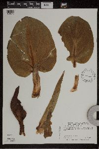 Symplocarpus foetidus (L.) Salisbury ex W. P. C. Barton 439014[1311648]Moriarity, J. M11999-04-23 United States, Minnesota, Ramsey, Ramsey County ... Battle Creek Park. At end of culdesac of the north arm of Pt. Douglas Road ...T28N R22W SE1/4 of Sec 3;Battle Creek County Park;028N;22W;03, 44.941333 -93.035318 |
MIN:Plants |  Symplocarpus foetidus (L.) Salisbury ex W. P. C. Barton 923928[1337629]Schimpf, D. DJS6062011-04-30 United States, Minnesota, Houston, Brownsville Township;Dorer Memorial Hardwood State Forest;102N;04W;11, 43.6472361 -91.2772361 |
MIN:Plants |  Symplocarpus foetidus (L.) Salisbury ex W. P. C. Barton 923292[1337617]Rowe, Erika ERR3682009-06-18 United States, Minnesota, Cass, Chippewa National Forest / Leech Lake Indian Reservation. T144N R27W NWNE 22...~290 SW of F.S. road 2127; 7.4 miles SW of Ball Club; 3.75 miles south of Hwy 2. North side of Six Mile Creek. 144N 27W 22, 47.2805556 -94.0808333 |
MIN:Plants |  Symplocarpus foetidus (L.) Salisbury ex W. P. C. Barton 960882[1329768]Perry, Ethan F. 170082017-06-20 United States, Minnesota, Koochiching, 2.9 miles northeast of Big Falls., 48.22 -93.76 |
MIN:Plants |  Symplocarpus foetidus (L.) Salisbury ex W. P. C. Barton 246262[1337647]Deam, Chas. C. 51961908-03-29 United States, Indiana, Wells, along creek on Shoemaker farm about 3 miles E of Bluffton, 40.738644 -85.114257 |
MIN:Plants |  Symplocarpus foetidus (L.) Salisbury ex W. P. C. Barton 446953[1337648]Abbot, Robinson S. s.n.1947-04-12 United States, Pennsylvania, Northumberland, Montandon, 40.965363 -76.850798 |
MIN:Plants |  Symplocarpus foetidus (L.) Salisbury ex W. P. C. Barton 360805[1337649]Minshall, W.H. 431939-05-20 Canada, Ontario, Carleton, Osgoode Station, 45.133333 -75.6 |
MIN:Plants |  Symplocarpus foetidus (L.) Salisbury ex W. P. C. Barton 288562[1337650]Kleinschind, A. s.n.1912-10-15 United States, Illinois, Du page |
MIN:Plants |  Symplocarpus foetidus (L.) Salisbury ex W. P. C. Barton 525090[1337651] s.n.1885-04-00 United States, Massachusetts |
MIN:Plants |  Symplocarpus foetidus (L.) Salisbury ex W. P. C. Barton 84534[1337652]Morris, E. L. s.n.1895-04-00 United States, Massachusetts, Hampshire |
MIN:Plants |  Symplocarpus foetidus (L.) Salisbury ex W. P. C. Barton 337490[1337653]Smith, L. B. 6381936-05-01 United States, Massachusetts, Norfolk |
MIN:Plants |  Symplocarpus foetidus (L.) Salisbury ex W. P. C. Barton 581235[1337654]Dutton, D. Lewis s.n.1923-04-30 United States, Vermont, Addison |
MIN:Plants | 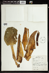 Symplocarpus foetidus (L.) Salisbury ex W. P. C. Barton 362423[1337655]Hayden, Ada 98231940-04-24 United States, Iowa, Linn, Clinton Township, about 3 miles NW of Cedar Rapids by Ellis Park river road and about 1 mile N of Covington Cemetery near end of lane; Hillside woodland bog, from which stream runs down under R. R. track, 42.039061 -91.685432 |
MIN:Plants | 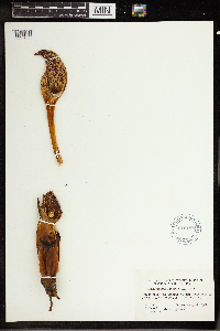 Symplocarpus foetidus (L.) Salisbury ex W. P. C. Barton 616199[1337656]Miller, Richard 2211968-02-22 United States, North Carolina, Watauga, branch head; Jim Council's farm; S face of Howard's Knob; Boone, 36.216795 -81.674552 |
MIN:Plants | 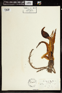 Symplocarpus foetidus (L.) Salisbury ex W. P. C. Barton 523448[1337657]Cooper, W. S. s.n.1903-03-31 United States, Michigan, Gratiot |
MIN:Plants | 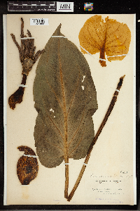 Symplocarpus foetidus (L.) Salisbury ex W. P. C. Barton 84539[1337658]Steele, E. S. s.n.1896-00-00 United States, District of Columbia |
MIN:Plants |  Symplocarpus foetidus (L.) Salisbury ex W. P. C. Barton 738841[1337659]Mustard, Timothy S. 2091977-04-14 United States, Michigan, Eaton, Fitzgerald Park, steam at western boundary of park, 42.759977 -84.762457 |
MIN:Plants |  Symplocarpus foetidus (L.) Salisbury ex W. P. C. Barton 766598[1337660]Pettit, R. H. s.n.1891-04-23 United States, New York, Tompkins, Fall Creek, 42.440628 -76.496607 |
MIN:Plants |  Symplocarpus foetidus (L.) Salisbury ex W. P. C. Barton 389585[1337661]Davies, Philip 12231927-03-12 United States, Wisconsin, Walworth, Isham's Springs; Delavan, 42.63307 -88.643714 |
MIN:Plants |  Symplocarpus foetidus (L.) Salisbury ex W. P. C. Barton 389582[1337662]Wadmond, S. C. 12231908-04-12 United States, Wisconsin, Walworth, W of Spring Grove Cemetery; Delavan, 42.638338 -88.637903 |
MIN:Plants | 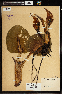 Symplocarpus foetidus (L.) Salisbury ex W. P. C. Barton 389584[1337663]Wadmond, S. C. 12231934-05-05 United States, Wisconsin, Chippewa, Chippewa co; Lafayette; Sec. 14, 44.908064 -91.317312 |
MIN:Plants | 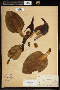 Symplocarpus foetidus (L.) Salisbury ex W. P. C. Barton 389583[1337664]Wadmond, S. C. 8811899-04-23 United States, Wisconsin, Racine, Horlicksville |
MIN:Plants | 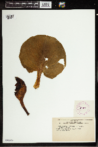 Symplocarpus foetidus (L.) Salisbury ex W. P. C. Barton 279527[1337667]Carpenter s.n.1925-05-03 United States, Vermont, Rutland |
MIN:Plants | 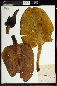 Symplocarpus foetidus (L.) Salisbury ex W. P. C. Barton 84527[1337668]Fink, B. s.n.1894-06-07 United States, Iowa, Fayette |
MIN:Plants |  Symplocarpus foetidus (L.) Salisbury ex W. P. C. Barton 84529[1337669]Durand, E. J. s.n.1892-04-06 United States, New York, Tompkins, Indian Spr. marsh, 42.440628 -76.496607 |
MIN:Plants |  Symplocarpus foetidus (L.) Salisbury ex W. P. C. Barton 84533[1337670]Wilkinson, E. 107571896-00-00 United States, Ohio, Richland |
MIN:Plants |  Symplocarpus foetidus (L.) Salisbury ex W. P. C. Barton 84528[1337671]Wilkinson, E. 107571896-00-00 United States, Ohio, Richland |
MIN:Plants |  Symplocarpus foetidus (L.) Salisbury ex W. P. C. Barton 84532[1337672]Wilkinson, E. 107571892-03-31 United States, Ohio, Richland |
MIN:Plants |  Symplocarpus foetidus (L.) Salisbury ex W. P. C. Barton 84531[1337673] s.n.1891-06-06 United States, New Jersey, Essex, Short Hills, 40.747879 -74.325427 |
MIN:Plants |  Symplocarpus foetidus (L.) Salisbury ex W. P. C. Barton 246264[1337674]Wilkinson, E. 107571896-00-00 United States, Ohio, Richland |
MIN:Plants |  Symplocarpus foetidus (L.) Salisbury ex W. P. C. Barton 716542[1337675]Rossbech, G. B. 9251956-05-12 United States, West Virginia, Pocahontas, along Deer Creek, 2550 ft E of Greenbrier River; between Cass and Green Bank, 38.405102 -79.866845 |
MIN:Plants |  Symplocarpus foetidus (L.) Salisbury ex W. P. C. Barton 544737[1337676]Daubenmire, R. F. s.n.1930-07-10 United States, Indiana, Parke |
MIN:Plants |  Symplocarpus foetidus (L.) Salisbury ex W. P. C. Barton 544738[1337677]Daubenmire, R. F. s.n.1930-02-26 United States, Indiana, Marion |
MIN:Plants |  Symplocarpus foetidus (L.) Salisbury ex W. P. C. Barton 470216[1337678]Rolland-Germain, F. 10711943-05-14 Canada, Quebec, Isle St. Paul, near Verdun., 45.45 -73.566667 |
MIN:Plants |  Symplocarpus foetidus (L.) Salisbury ex W. P. C. Barton 643853[1337679]Ahles, Harry E. 785481973-08-18 United States, Massachusetts, Hampshire, South Amherst, 42.340368 -72.505087 |
MIN:Plants |  Symplocarpus foetidus (L.) Salisbury ex W. P. C. Barton 643862[1337680]Ahles, Harry E. 763361973-03-24 United States, New York, Dutchess, N of Cardinal Road and W of Forest Drive; Hyde Park, 41.799431 -73.893933 |
MIN:Plants |  Symplocarpus foetidus (L.) Salisbury ex W. P. C. Barton 337489[1337681]Smith, L. B. 6371936-03-23 United States, Massachusetts, Norfolk |
MIN:Plants | 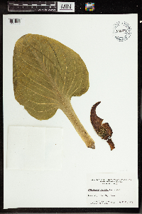 Symplocarpus foetidus (L.) Salisbury ex W. P. C. Barton 643971[1337682]Ahles, Harry E. 763461973-04-21 United States, New Hampshire, Cheshire, Keene; Silent Way, 42.914654 -72.275155 |
MIN:Plants | Symplocarpus foetidus (L.) Salisbury ex W. P. C. Barton []Timothy J. S. Whitfeld 35212023-05-10 United States, Minnesota, Washington, Crystal Spring Scientific and Natural Area, 0.4 miles northeast of the intersection of Scandia Trail North and Hwy 95, 45.25575 -92.764608, 241m |
Google Map
Google Maps is a web mapping service provided by Google that features a map that users can pan (by dragging the mouse) and zoom (by using the mouse wheel). Collection points are displayed as colored markers that when clicked on, displays the full information for that collection. When multiple species are queried (separated by semi-colons), different colored markers denote each individual species.