University of Minnesota
http://www.umn.edu/
612-625-5000
http://www.umn.edu/
612-625-5000
Minnesota Biodiversity Atlas
Bell Museum
Dataset: MIN-Plants
Taxa: Amaranthaceae
Search Criteria: excluding cultivated/captive occurrences
Bell Museum plants | |
 MIN:Plants |  Chenopodium standleyanum Aellen 104482[1192601]Bergman, H. F. 1115 United States, North Dakota, Barnes |
MIN:Plants |  Chenopodium standleyanum Aellen 104479[1192602]Steele, E. S. s.n. United States, District of Columbia |
MIN:Plants |  Chenopodium standleyanum Aellen 104480[1192603]Heller, A. A. 657 United States, Pennsylvania, Northampton |
MIN:Plants |  Chenopodium standleyanum Aellen 104478[1192604]Bates, J. M. 8944 United States, Nebraska, Webster |
MIN:Plants |  Chenopodium standleyanum Aellen 247369[1192605]Stevens, O. A. s.n. United States, North Dakota, Cass |
MIN:Plants |  Chenopodium standleyanum Aellen 247383[1192606]Johnson, C. F. s.n. United States, Illinois, Stephenson |
MIN:Plants |  Chenopodium standleyanum Aellen 225210[1192607]Rydberg, P. A. 5153 United States, Wisconsin, Pierce |
MIN:Plants |  Chenopodium standleyanum Aellen 352931[1192608]Nielsen, E. L. 3445 United States, Nebraska, Holt |
MIN:Plants | 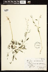 Chenopodium standleyanum Aellen 593187[1192609]Hartley, T. G. 8460 United States, Iowa, Winneshiek |
MIN:Plants | 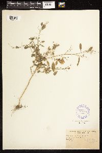 Chenopodium standleyanum Aellen 345777[1192610]Pease, A. S. 12456 United States, Illinois, Champaign |
MIN:Plants | 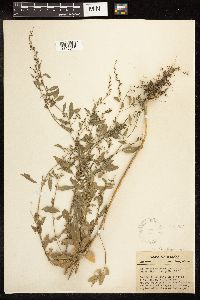 Chenopodium standleyanum Aellen 299307[1192611]Deam, C. C. 18296 United States, Indiana, Knox |
MIN:Plants | 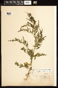 Chenopodium standleyanum Aellen 104477[1192612]Mackenzie, K. K. s.n. United States, Missouri, Jackson |
MIN:Plants | 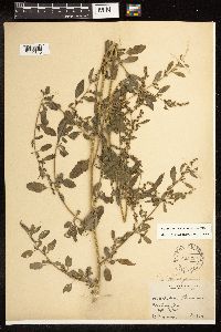 Chenopodium standleyanum Aellen 225229[1192613]Bush, B. F. 8111 United States, Missouri, Jackson |
MIN:Plants | 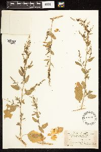 Chenopodium standleyanum Aellen 490191[1192614]Stevens, O. A. 72 United States, North Dakota, Cass |
MIN:Plants | 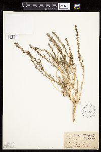 Kochia americana S. Watson 105000[1037532]Coville, Frederick; Funston, Frederick 9051891-06-11 United States, California, Inyo, Darwin Mesa, Inyo County.;Death Valley National Park, 1450m |
MIN:Plants | 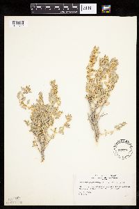 Atriplex confertifolia (Torrey & Fr̩mont) S. Watson 527776[1036759]Weber, W. s.n.1954-05-16 United States, Colorado, Mesa, Mesa Co.: escarpment, Fruita entrance, Colo. Nat. Monument;Colorado National Monument |
MIN:Plants | Atriplex confertifolia (Torrey & Fr̩mont) S. Watson 456070[]Davis, Owen s.n.1979-09-13 United States, Idaho, Cassia, [no further data] |
MIN:Plants |  Atriplex confertifolia (Torrey & Fr̩mont) S. Watson 573849[1036757]Stevens, O. 24121961-06-21 United States, North Dakota, Billings, Theodore Roosevelt National Memorial Park. Medora;Theodore Roosevelt National Park |
MIN:Plants |  Atriplex confertifolia (Torrey & Fr̩mont) S. Watson 279307[1036758]Goodman, G.; Hitchcock, C. 13651930-06-29 United States, Colorado, Montezuma, N entrance to Mesa Verde National Park;Mesa Verde National Park, 2134m |
MIN:Plants |  Atriplex confertifolia (Torrey & Fr̩mont) S. Watson 794689[1036760]Schaaf, J. 301982-07-27 United States, Nevada, Pershing, Pershing Co. ... SR 399 MP-16-17.21, 1250m |
MIN:Plants | Atriplex confertifolia (Torrey & Fr̩mont) S. Watson 454029[]Davis, Owen s.n.1978-08-28 United States, Idaho, Bingham, [no further data] |
MIN:Plants | Atriplex confertifolia (Torrey & Fr̩mont) S. Watson []Allen, A. GW25052005-06-29 United States, Colorado, Delta, Adobe Hills, 38.761528 -107.6515, 2070m |
MIN:Plants | Atriplex gardneri (Moquin-Tandon) D. Dietrich 427135[]Davis, Owen s.n.1979-09-13 United States, Idaho, Cassia, [no further data] |
MIN:Plants | Atriplex gardneri (Moquin-Tandon) D. Dietrich []Prenot, C. GW25062005-06-29 United States, Colorado, Delta, Adobe Hills, 38.761528 -107.6515, 2070m |
MIN:Plants |  Halogeton glomeratus (M. Bieberstein) C.A. Meyer 794724[1037531]DeBunch, P. 321983-10-01 United States, Nevada, Elko, Elko Co. ... near Oasis, along I-80, MP 112, 1829m |
MIN:Plants |  Atriplex californica Moquin-Tandon 295955[1036747]Clokey, Ira 49181930-06-04 United States, California, Santa Barbara, Santa Barbara Islands...Santa Cruz Island;Channel Islands |
MIN:Plants |  Chenopodium cornutum (Torr.) Benth. & Hook. f. ex S. Watson 104530[1192239]Holzinger, J. M. s.n. United States, New Mexico, Grant |
MIN:Plants |  Chenopodium cornutum (Torr.) Benth. & Hook. f. ex S. Watson 104529[1192240]Heller, A. A. 3844 United States, New Mexico, Santa Fe |
MIN:Plants |  Chenopodium cornutum (Torr.) Benth. & Hook. f. ex S. Watson 104532[1192241]Metcalfe, O. B. 604 United States, New Mexico, Socorro |
MIN:Plants |  Chenopodium cornutum (Torr.) Benth. & Hook. f. ex S. Watson 104536[1192242]Earle, F. S. 401 United States, New Mexico, Lincoln |
MIN:Plants |  Chenopodium cornutum (Torr.) Benth. & Hook. f. ex S. Watson 104537[1192243]Rusby, H. H. 365 United States, New Mexico, [Socorro] |
MIN:Plants |  Chenopodium cornutum (Torr.) Benth. & Hook. f. ex S. Watson 299303[1192244]Metcalfe, O. B. 1305 United States, New Mexico, Sierra |
MIN:Plants |  Chenopodium cornutum (Torr.) Benth. & Hook. f. ex S. Watson 104534[1192245]Rothrock, J. T. 737 United States, Arizona, Graham |
MIN:Plants |  Chenopodium cornutum (Torr.) Benth. & Hook. f. ex S. Watson 247421[1192246]Wooton, E. O. 3476 United States, New Mexico, Lincoln |
MIN:Plants |  Chenopodium cornutum (Torr.) Benth. & Hook. f. ex S. Watson 104533[1192247]Heller, A. A. 3844 United States, New Mexico, Santa Fe |
MIN:Plants |  Chenopodium cornutum (Torr.) Benth. & Hook. f. ex S. Watson 104535[1192248]Wooton, E. O. 301 United States, New Mexico, Lincoln |
MIN:Plants | 708345[]Ownbey, Gerald 6495-21979-09-16 United States, Minnesota, Freeborn, Freeborn County ... Albert Lea;;;;, 43.648013 -93.368266 |
MIN:Plants | 708354[]Ownbey, Gerald 6495-81979-09-16 United States, Minnesota, Freeborn, Freeborn County ... Albert Lea;;;;, 43.648013 -93.368266 |
MIN:Plants |  412691[1036817]Moore, John; et al. 114731939-08-05 United States, Minnesota, Roseau, Roseau County...along the north bank of the Warroad River, Warroad.;;163N;36W;, 48.930291 -95.287489 |
MIN:Plants |  Kochia scoparia subsp. scoparia (L.) Schrader 913899[1037555]Smith, Welby 254921994-09-13 United States, Minnesota, Murray, Lake Shetek State Park. About 3 miles northwest of Currie. Lake Shetek. SW1/4 of SW1/4 of section of SW1/4 of Sec 31. 107N 40W 31, 44.1111111 -95.7011111 |
MIN:Plants |  Kochia scoparia subsp. scoparia (L.) Schrader 282291[1037564]Dellman, J. s.n.1932-09-00 United States, Minnesota, Hennepin, Minneapolis;;;;, 44.979965 -93.263836 |
MIN:Plants |  Kochia scoparia subsp. scoparia (L.) Schrader 353163[1037553]Nielsen, E. 17171932-09-20 United States, Minnesota, Dakota, 1 mi E of village of Savage, Carver Co. [this actually in Dakota Co.];;115N;21W;, 44.770189 -93.307702 |
MIN:Plants |  Kochia scoparia subsp. scoparia (L.) Schrader 364304[1037556]Rosendahl, C. s.n.1933-08-20 United States, Minnesota, Ramsey, Along sidewalk, Commonwealth Ave, St. Anthony Park [St. Paul neighborhood near U of M];;029N;23W;, 44.992077 -93.166387 |
MIN:Plants |  Kochia scoparia subsp. scoparia (L.) Schrader 367364[1037562]Moore, John; Moore, Marjorie 105391938-09-15 United States, Minnesota, Lincoln, Lake Benton;;109N;45W;, 44.24108 -96.26172 |
MIN:Plants |  Kochia scoparia subsp. scoparia (L.) Schrader 413751[1037548]Moore, John; Moore, Marjorie 101681937-09-20 United States, Minnesota, Dakota, Along Concord Street, S of the tannery, South St. Paul;;028N;22W;, 44.905226 -93.045075 |
MIN:Plants |  Kochia scoparia subsp. scoparia (L.) Schrader 501530[1037561]Stevens, O. s.n.1954-09-14 United States, Minnesota, Pipestone, Along quarry trail;Pipestone National Monument;106N;46W;, 43.979723 -96.367859 |
MIN:Plants |  Kochia scoparia subsp. scoparia (L.) Schrader 526038[1037559]Lakela, Olga 195841955-10-09 United States, Minnesota, Saint Louis, Boulevard, First Street and Seventh Ave. East, Duluth;;;;, 46.79438 -92.0907 |
MIN:Plants |  Kochia scoparia subsp. scoparia (L.) Schrader 526436[1037546]Moore, John 212151951-08-07 United States, Minnesota, Wilkin, Along the rail road 1 mi N of Doran;;;;, 46.198604 -96.48257 |
MIN:Plants |  Kochia scoparia subsp. scoparia (L.) Schrader 549964[1037565]Moore, John; Ownbey, Gerald 222251954-09-21 United States, Minnesota, Pipestone, 1.5 mi NW of Pipestone;;106N;46W;, 43.979723 -96.367859 |
MIN:Plants |  Kochia scoparia subsp. scoparia (L.) Schrader 554088[1037566]Moore, John 226721955-07-27 United States, Minnesota, Clay, At Barnesville;;;;, 46.652182 -96.41979 |
MIN:Plants |  Kochia scoparia subsp. scoparia (L.) Schrader 558219[1037567]Moore, John; Hsi, Yu-tseng [Eugene] 234451957-08-08 United States, Minnesota, Blue Earth, Roadside at Mankato;;;;, 44.163578 -93.9994 |
MIN:Plants |  Kochia scoparia subsp. scoparia (L.) Schrader 558529[1037557]Moore, John; Moore, Marjorie 235541957-09-19 United States, Minnesota, Isanti, Old house site, Cedar Creek Forest; Athens Twp. NW1/4 of section;Cedar Creek National History Area;034N;23W;16, 45.435724 -93.214819 |
MIN:Plants |  Kochia scoparia subsp. scoparia (L.) Schrader 565207[1037545]Cotter Tucker, Shirley 42181957-08-06 United States, Minnesota, Polk, Along Great Northern railroad, E of Northwest School of Agriculture, Crookston;;;;, 47.796437 -96.621603 |
MIN:Plants |  Kochia scoparia subsp. scoparia (L.) Schrader 566503[1037568]Moore, John; Heig, V. 239971958-09-08 United States, Minnesota, Kittson, At Hallock;;161N;49W;, 48.760418 -96.996127 |
MIN:Plants |  Kochia scoparia subsp. scoparia (L.) Schrader 585444[1037549]Moore, John 261871962-10-02 United States, Minnesota, Houston, 1 mi N of La Crescent;;104N;04W;, 43.801454 -91.319283 |
MIN:Plants |  Kochia scoparia subsp. scoparia (L.) Schrader 590418[1037552]Ownbey, Gerald; Johnson, Miles 38361965-08-18 United States, Minnesota, Polk, 2 mi W, 2.5 mi N of Eldred. W1/2 NW1/4 of section;Malmberg Prairie Scientific Natural Area;149N;48W;16, 47.72417 -96.813965 |
MIN:Plants |  Kochia scoparia subsp. scoparia (L.) Schrader 592371[1037551]Westkaemper, Remberta s.n.1964-00-00 United States, Minnesota, Stearns, St. Joseph; around building under construction;;124N;29W;, 45.543642 -94.322053 |
MIN:Plants |  Kochia scoparia subsp. scoparia (L.) Schrader 598578[1037554]Abbott, Robinson 1958-09-01 United States, Minnesota, Hennepin, Just N. of Camden section, Minneapolis, on Tyndale Ave, by Miss. Ct.;;028N;23W;, 44.905162 -93.166462 |
MIN:Plants |  Kochia scoparia subsp. scoparia (L.) Schrader 602227[1037560]Westkaemper, Remberta s.n.1962-07-00 United States, Minnesota, Stearns, SBC [St. Benedict College] campus, St. Joseph;;124N;29W;, 45.543642 -94.322053 |
MIN:Plants |  Kochia scoparia subsp. scoparia (L.) Schrader 618945[1037563]Monserud, W. 1661949-08-08 United States, Minnesota, Hennepin, Backyard at 5255 Dupont Ave. No, Minneapolis;;;;, 45.05112 -93.29414 |
MIN:Plants |  Kochia scoparia subsp. scoparia (L.) Schrader 645886[1037569]Westkaemper, Remberta s.n.1970-09-00 United States, Minnesota, Stearns, St. Joseph;;124N;29W;, 45.543642 -94.322053 |
MIN:Plants |  Kochia scoparia subsp. scoparia (L.) Schrader 670150[1037535]Westkaemper, Remberta s.n.1974-08-00 United States, Minnesota, Stearns, Game preserve, St. Joseph;<No data>;;;, 45.543642 -94.322053 |
MIN:Plants |  Kochia scoparia subsp. scoparia (L.) Schrader 681715[1037534]Gustitus, J. 11973-09-21 United States, Minnesota, Ramsey, Univ. of Minn, St. Paul campus, in lot near chicken house;;029N;23W;, 44.992077 -93.166387 |
MIN:Plants |  Kochia scoparia subsp. scoparia (L.) Schrader 687518[1037558]Wheeler, Gerald; Glaser, Paul 19601977-07-09 United States, Minnesota, Itasca, Collection site no. 99, ca. 21 mi WNW of Grand Rapids, railroad track embankment just E of where the tracks cross the Mississippi River (east bank). NE1/4 NW1/4 of section;Chippewa National Forest / Leech Lake Indian Reservation;145N;26W;03, 47.404599 -93.956013 |
MIN:Plants |  Kochia scoparia subsp. scoparia (L.) Schrader 709707[1037547]Wheeler, Gerald 47161979-08-03 United States, Minnesota, Lac Qui Parle, Salt Lake, ca. 3.5 mi SW of Marietta, near the shore of the lake;;117N;46W;05, 44.972372 -96.443681 |
MIN:Plants |  Kochia scoparia subsp. scoparia (L.) Schrader 724445[1037550]Smith, Welby 34001980-08-17 United States, Minnesota, Wright, On the NW shore of Howard Lake. SW1/4 SE1/4 of section;;119N;27W;28, 45.08695 -94.084081 |
MIN:Plants |  Kochia scoparia subsp. scoparia (L.) Schrader 739557[1037533]Converse, C. 22291982-09-05 United States, Minnesota, Otter Tail, E1/2 of section;Ottertail Prairie Scientific Natural Area;131N;44W;17, 46.159244 -96.235363 |
MIN:Plants |  Kochia scoparia subsp. scoparia (L.) Schrader 744668[1037543]Converse, C. 22691982-08-24 United States, Minnesota, Otter Tail, E1/2 of section;Ottertail Prairie Scientific Natural Area;131N;44W;17, 46.159244 -96.235363 |
MIN:Plants |  Kochia scoparia subsp. scoparia (L.) Schrader 745263[1037537]Smith, Welby 55731981-08-26 United States, Minnesota, Mower, About 2 mi ESE of the junction of state hwy 56 and co. hwy 2 in Brownsdale. SE1/4 SE1/4 of section;Wild Indigo Scientific Natural Area;103N;17W;11, 43.739545 -92.839221 |
MIN:Plants |  Kochia scoparia subsp. scoparia (L.) Schrader 755833[1037544]Davis, Owen MN76-21976-10-31 United States, Minnesota, Hennepin, 515 15th Ave. SE;;;;, 44.98245 -93.23271 |
MIN:Plants |  Kochia scoparia subsp. scoparia (L.) Schrader 813059[1037536]Wheeler, Gerald 119181988-08-20 United States, Minnesota, Norman, Ca. 3.5 mi SSE of Gary, N of rte 200, near North Branch Wild Rice River. SE1/4 SE1/4 of section;;145N;44W;34, 47.33269 -96.24767 |
MIN:Plants |  Kochia scoparia subsp. scoparia (L.) Schrader 813060[1037540]Wheeler, Gerald 121441988-09-10 United States, Minnesota, Traverse, Ca. 11 mi E of Browns Valley, wildlife area N of rte 2, on W side of lake. SW1/4 of section;Foley Wildlife Management Area;125N;47W;29, 45.607514 -96.60438 |
MIN:Plants |  Kochia scoparia subsp. scoparia (L.) Schrader 813539[1037538]Wheeler, Gerald 121811988-09-11 United States, Minnesota, Big Stone, Ca. 1.2 mi NW of Barry, ca. 0.3 mi E of rte 57, between Barry Lake and road. SE1/4 NW1/4 of secton;Barry Lake Wildlife Management Area;124N;47W;08, 45.565691 -96.586118 |
MIN:Plants |  Kochia scoparia subsp. scoparia (L.) Schrader 834023[1037542]Smith, Welby 161621989-08-23 United States, Minnesota, Nobles, About 4 mi NW of Worthington. NW1/4 NW1/4 of section;Herlein-Boote Wildlife Management Area;102N;40W;07, 43.6588889 -95.6919444 |
MIN:Plants |  Kochia scoparia subsp. scoparia (L.) Schrader 834024[1037539]Smith, Welby 161951989-08-23 United States, Minnesota, Nobles, About 10 mi NW of Worthington. NW1/4 NW1/4 of section;Groth Wildlife Management Area;103N;41W;02, 43.754218 -95.722931 |
MIN:Plants |  Kochia scoparia subsp. scoparia (L.) Schrader 909198[1037570]Smith, Welby 219401992-09-07 United States, Minnesota, Watonwan, On the north side of Kansas Lake, about 5 mi SW of St. James. NE1/4 of NE1/4 of section;;105N;32W;08, 43.92 -94.7022222 |
MIN:Plants |  Kochia scoparia subsp. scoparia (L.) Schrader 478133[1037541]Wheeler, Gerald 201741999-08-01 United States, Minnesota, Sibley, W side of Winthrop. NW1/4 of section;;112N;29W;01, 44.536177 -94.260407 |
MIN:Plants | 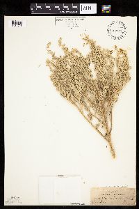 Atriplex canescens canescens (Pursh) Nutall 522507[1036756]Wooton, E. s.n.1899-06-19 United States, New Mexico, Dona Ana, White Sands, Dona Ana Co.;White Sands National Monument |
MIN:Plants | 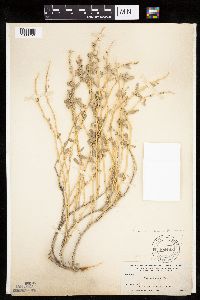 Atriplex canescens canescens (Pursh) Nutall 104145[1036750]Nelson, Aven; et al. 59951899-07-19 United States, Wyoming, Park, Gardiner River;Yellowstone National Park |
MIN:Plants | 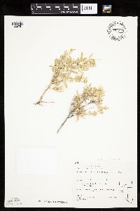 Atriplex canescens canescens (Pursh) Nutall 794778[1036751]Schaaf, J. 291982-07-26 United States, Nevada, Pershing, Pershing Co. ... above Rye Patch Res., 1280m |
MIN:Plants | 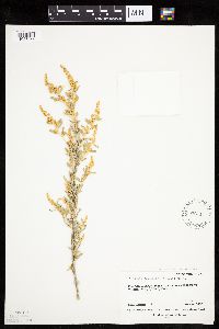 Atriplex canescens canescens (Pursh) Nutall 576711[1036755]Erdman, J. 561959-06-17 United States, Colorado, Montezuma, Montezuma Co.: Mesa Verde National Park. Wetherill Mesa;Mesa Verde National Park, 2438m |
MIN:Plants | 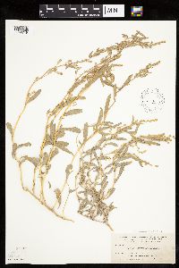 Atriplex canescens canescens (Pursh) Nutall 103993[1036749]Nelson, Aven; et al. 59761899-07-19 United States, Wyoming, Park, Gardiner River;Yellowstone National Park |
MIN:Plants | 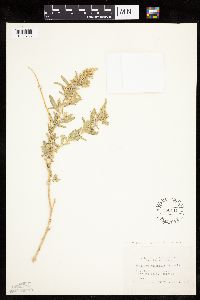 Atriplex canescens canescens (Pursh) Nutall 550411[1036753]Cotter, Shirley 8131950-06-15 United States, South Dakota, Pennington, Pennington County...Badlands;Badlands National Monument |
MIN:Plants | 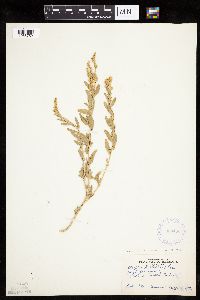 Atriplex canescens canescens (Pursh) Nutall 333453[1036752]Brannon, M. s.n.1896-08-12 United States, North Dakota, Slope, Marmarth |
MIN:Plants | 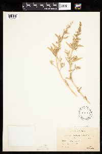 Atriplex canescens canescens (Pursh) Nutall 536303[1036754]Brenckle, J. 40-371940-09-20 United States, South Dakota, Pennington, Badlands...east of Wall;Badlands National Monument |
MIN:Plants |  332055[1037113]Moyle, J. 20501935-08-21 United States, Minnesota, Kandiyohi, Norway Lake;;;;, 45.320377 -95.121252 |
MIN:Plants |  337081[1037119]Lakela, Olga 17161936-08-16 United States, Minnesota, Saint Louis, Oatka Beach Addition near Minnesota Ave. at 42nd St....Duluth.;Minnesota Point;049N;13W;18, 46.74205 -92.06285 |
MIN:Plants |  360420[1037114]Rosendahl, C. 64521933-09-06 United States, Minnesota, Kandiyohi, Foot Lake, near Willmar, Kandiyohi County;;119N;35W;, 45.110139 -95.062995 |
MIN:Plants |  440845[1037108]Haferman, J. 1841995-09-30 United States, Minnesota, Scott, Scott Co. T115N R22W S36 SW of SW. Approx. 0.1 mi north-northeast of intersection of State Highway 13 and County Road 44 on north side of highway.. 115N 22W 36, 44.724586 -93.409031 |
MIN:Plants |  448021[1037118]Abbott, Robinson s.n.1961-08-01 United States, Minnesota, Stevens, Stevens County...Page Lake E. of Hancock.;;124N;41W;27, 45.520797 -95.799002 |
MIN:Plants |  460562[1037110]Smith, Welby 145961988-07-22 United States, Minnesota, Washington, Afton State Park. Wawshington County...In Afton State Park, about 3 miles south of the town of Afton...beach of the St. Croix River... NE1/4 NW1/4 section 2, T 27N R 20W.. 027N 20W 2, 44.854763 -92.775046 |
MIN:Plants |  554444[1037117]Moore, John 232961957-06-19 United States, Minnesota, Martin, Martin County...east shore of Big Twin Lake, 2-1/2 miles south west of Monterey.;;103N;33W;, 43.718294 -94.794347 |
MIN:Plants |  566668[1037115]Moore, John; Bernardini, J. 243141958-09-19 United States, Minnesota, Blue Earth, Blue Earth County...Growing along the Blue Earth River, 1 mile south of Mankato.;;108N;27W;, 44.152457 -94.068583 |
MIN:Plants |  574651[1037116]Moore, John 245711959-06-04 United States, Minnesota, Blue Earth, Blue Earth County...Growing along the north shore of Loon Lake.;;107N;28W;03, 44.101228 -94.178562 |
MIN:Plants |  628150[1037107]Ownbey, Gerald 46531972-08-17 United States, Minnesota, Mahnomen, Mahnomen County...Sullivan Lake, Rte. 113, ca. 1 mi east of Waubun. On south side of fill through lake;White Earth Indian Reservation;143N;41W;00, 47.194255 -95.869088 |
MIN:Plants |  812566[1037111]Wheeler, Gerald 113231988-07-24 United States, Minnesota, Big Stone, Big Stone County...Ca. 6 mi. NNE of Ortonville; N of Rte. 62...along margin of Thielke Lake (SW shore)...W1/2 SE1/4 SW1/4 Sec. 11, T122N, R46W. 122N 46W 11, 45.391492 -96.400528 |
MIN:Plants |  461934[1037109]Wheeler, Gerald 170151997-08-08 United States, Minnesota, Swift, Swift County...Ca. 5 mi. NNE of Benson; on NW margin of Frovold Lake ... NW1/4 SE1/4 NE1/4 Sec. 16 T122N R39W;;122N;39W;16, 45.376026 -95.571928 |
MIN:Plants |  903816[1037112]Lee, Michael MDL4168A2005-09-08 United States, Minnesota, Stearns, STEARNS COUNTY ... Along the Mississippi River on the north side of St. Cloud. On downstream end of small island at the mouth of the Sauk River ... T125N R28W E1/2 of NW1/4 of SW1/4 Sec.35 (small, irregular section). 125N 28W 35, 45.589261 -94.176157 |
MIN:Plants |  429080[1037106]Wheeler, Gerald 170231997-08-08 United States, Minnesota, Swift, Swift County ... Ca. 6 mi. NNE of Benson; NW shore of Lake Hassel, at public water access ..NE1/4 NW1/4 Sec.9 T122N R39W (Benson 9). 122N 39W 9, 45.39048 -95.571817 |
MIN:Plants |  545846[1192352]Scoggan, H. J. 6167 Canada, Manitoba |
Google Map
Google Maps is a web mapping service provided by Google that features a map that users can pan (by dragging the mouse) and zoom (by using the mouse wheel). Collection points are displayed as colored markers that when clicked on, displays the full information for that collection. When multiple species are queried (separated by semi-colons), different colored markers denote each individual species.