University of Minnesota
http://www.umn.edu/
612-625-5000
http://www.umn.edu/
612-625-5000
Minnesota Biodiversity Atlas
Bell Museum
Dataset: MIN-Plants
Taxa: Amaranthaceae
Search Criteria: excluding cultivated/captive occurrences
Bell Museum plants | |
 MIN:Plants |  Chenopodium NULL 104531[1122485]Blumer, J. 13811906-09-15 United States, Arizona, Cochise, Chiricahua Mountains...Barfoot Park, 2515m |
MIN:Plants |  Chenopodium NULL 485096[1122482]Cholewa, A. 25061997-07-31 United States, Minnesota, Anoka, Ham Lake County Park [now a city park] (in the town of Ham Lake)...between ball fields and picnic shelter.;;032N;23W;21, 45.247884 -93.214062 |
MIN:Plants |  Chenopodium NULL 813016[1122484]Morley, T. 17041990-08-03 United States, Minnesota, Ramsey, New Brighton...N of oak woods between Rush Lake and the railroad. S1/4 NW1/4 SE1/4 of section;Long Lake County Park;030N;23W;17, 45.08629 -93.198398 |
MIN:Plants |  Chenopodium NULL 439186[1122483]Dana, R. 880251988-08-15 United States, Minnesota, Big Stone, Glacial River Warren gorge, above present-day Big Stone Lake. SW1/4 of SW1/4 of section;;123N;47W;31, 45.421036 -96.606564 |
MIN:Plants |  Chenopodium NULL 520295[1122481]Smith, Welby 210661992-07-20 United States, Minnesota, Redwood, about 4 miles N-NW of Redwood Falls. NW1/4 of NW1/4 of Section;Cedar Rock Wildlife Management Area;113N;36W;11, 44.6122222 -95.1563889 |
MIN:Plants |  Chenopodium NULL 104336[1191925]Martindale, I.C. s.n. United States, New Jersey, Camden |
MIN:Plants |  Chenopodium NULL 231007[1191926]Congdon, J.W. s.n. United States, California, Santa Clara |
MIN:Plants |  Chenopodium NULL 104332[1191927]Metcalfe, O.B. 217 United States, New Mexico, Grant |
MIN:Plants |  Chenopodium NULL 595563[1191928]Welsh, S.L. 3794 United States, Utah, Utah |
MIN:Plants |  Chenopodium NULL 618271[1191929]Iltis, H.H. 12060 United States, Wisconsin, Monroe |
MIN:Plants |  Chenopodium NULL 279955[1191930]Bush, B. F. 11621 United States, Missouri, Jackson |
MIN:Plants |  Chenopodium NULL 225234[1191931]Bush, B. F. 8021 United States, Missouri, Jackson |
MIN:Plants |  Chenopodium NULL 246461[1191932]Lunell, J. 595 United States, North Dakota, Burleigh |
MIN:Plants |  Chenopodium NULL 104680[1191933]Williams, T. A. s.n. United States, South Dakota, Brookings |
MIN:Plants |  Chenopodium NULL 104654[1191934]Moyer, L. R. 149 United States, South Dakota, Meade |
MIN:Plants |  Chenopodium NULL 546665[1191935]Scoggan, H. J. 11227 Canada, Manitoba |
MIN:Plants |  Chenopodium NULL 602321[1191936]Monserud, W. 997 United States, South Dakota, Day |
MIN:Plants |  966416[1356953] 1944-08-21 United States, South Dakota, Codington |
MIN:Plants | Atriplex NULL 454115[]Smith, O. s.n.1924-07-07 United States, Idaho, Twin Falls, Twin Falls Co. Above Snake R, W of Hagerman, 853m |
MIN:Plants |  Atriplex NULL 552197[1122479]Stevens, O. 20341958-09-22 United States, Minnesota, Clay, (Clay Co.);;139N;48W;, 46.845648 -96.728846 |
MIN:Plants | Amaranthus NULL 480949[]Northrup King Corp. s.n. United States, [no data] |
MIN:Plants |  Corispermum NULL 782187[1122518]Dana, R. 850571985-07-17 United States, Minnesota, Norman, Norman County...NE1/4 SE1/4 Sec. 18, T146N, R44W.;Prairie Smoke Dunes Scientific Natural Area;146N;44W;18, 47.46366 -96.313166 |
MIN:Plants |  Chenopodium berlandieri Moquin-Tandon 630497[1037030]Halse, Richard 6121971-08-10 United States, Arizona, Apache, Antelope House Ruins, Canyon del Muerto, Canyon de Chelly National Monument;Canyon de Chelly National Monument, 1743m |
MIN:Plants |  Chenopodium berlandieri Moquin-Tandon 479277[1037027]DeMink, L. 4072000-09-17 United States, Minnesota, Morrison, Crane Meadows National Wildlife Refuge; SWNE 30-T40N-R31W;Crane Meadows National Wildlife Refuge;040N;31W;30, 45.933896 -94.251564 |
MIN:Plants |  Chenopodium berlandieri Moquin-Tandon 479226[1037026]Husveth, J. 95-17221995-09-04 United States, Minnesota, Goodhue, Goodhue Co, T113N R15W SE1/4 of the NE1/4 of s19; Cannon River;Dorer Memorial Hardwood State Forest;113N;15W;19, 44.579109 -92.662048 |
MIN:Plants |  Chenopodium berlandieri Moquin-Tandon 552146[1037028]Stevens, O. 20011958-08-21 United States, Minnesota, Clay, Moorhead (Clay Co.);;N;;, 46.845648 -96.728846 |
MIN:Plants |  Chenopodium berlandieri Moquin-Tandon 478829[1037025]Husveth, J. 95-17371995-09-04 United States, Minnesota, Goodhue, Goodhue Co, T113N R15W SE1/4 of the NE1/4 of S19; along Cannon River;Dorer Memorial Hardwood State Forest;113N;15W;19, 44.579109 -92.662048 |
MIN:Plants |  Chenopodium berlandieri Moquin-Tandon 438241[1037029]Cully, Anne; et al. s.n.1998-08-10 United States, Minnesota, Pipestone, Pipestone County, Pipestone National Monument UTM 0714399N 4876297E;Pipestone National Monument;106N;46W;01, 44.015848 -96.317669 |
MIN:Plants |  Chenopodium berlandieri Moquin-Tandon 937215[1122496]Anderson, Chel; Lee, Jeffrey 22552012-07-29 United States, Minnesota, Lake, Above Kekakabic Lake. UTM: 5326481.161783 / 636744.864168. NE1/4 NE1/4 of section.;Boundary Waters Canoe Area Wilderness / Superior National Forest;065N;07W;36, 48.0769194 -91.1640822 |
MIN:Plants |  Chenopodium berlandieri Moquin-Tandon 447959[1192101]Abbott, R. S. s.n. United States, Texas, Nueces |
MIN:Plants |  Chenopodium berlandieri Moquin-Tandon 305127[1192102]Lunell, J. s.n. United States, North Dakota, Benson |
MIN:Plants |  Chenopodium berlandieri Moquin-Tandon 225240[1192103]Bush, B. F. 8021 United States, Missouri, Jackson |
MIN:Plants |  Chenopodium berlandieri Moquin-Tandon 225236[1192104]Runyon, R. 287 United States, Texas, Cameron |
MIN:Plants |  Chenopodium berlandieri Moquin-Tandon 225237[1192105]Bush, B. F. 8808 United States, Missouri, Jackson |
MIN:Plants |  Chenopodium berlandieri Moquin-Tandon 299305[1192106]Deam, C. C. 14466 United States, Indiana, Allen |
MIN:Plants |  Chenopodium berlandieri Moquin-Tandon 530833[1192107]Rood, A. N. 1800 United States, Ohio, Trumbull |
MIN:Plants |  Chenopodium berlandieri Moquin-Tandon 379843[1192108]Ek, C. M. s.n. United States, Indiana, Howard |
MIN:Plants |  Chenopodium berlandieri Moquin-Tandon 104466[1192109]Bebb, M. S. s.n. United States, Illinois, Winnebago |
MIN:Plants |  Chenopodium berlandieri Moquin-Tandon 104467[1192110]Mackenzie, K. K. 28 United States, Missouri, Jackson |
MIN:Plants |  Chenopodium berlandieri Moquin-Tandon 451680[1192111]Demaree, D. 26914 United States, Arkansas, White |
MIN:Plants |  Chenopodium berlandieri Moquin-Tandon 490195[1192112]Stevens, O. A. 11 United States, North Dakota, Cass |
MIN:Plants |  Chenopodium berlandieri Moquin-Tandon 953718[1294567]Bennett, H. R. 7785 United States, Idaho, Lemhi |
MIN:Plants | Bassia hyssopifolia (Pallas) Kuntze 454055[]Bright, R. 71-21971-00-00 United States, Idaho, Bannock, [no further data] |
MIN:Plants |  Bassia hyssopifolia (Pallas) Kuntze 794905[1036816]DeBunch, P. 331983-10-01 United States, Nevada, Humboldt, Humboldt Co. ... South of Winnemucca along I-80 ... Elev. 4500 ft. |
MIN:Plants | Salicornia rubra A. Nelson 435223[1122476]Bright, R. United States, Idaho, Franklin, Detailed locality information protected. This is typically done to protect rare or threatened species localities. |
MIN:Plants | Salicornia rubra A. Nelson 909937[1037588]Gockman, Otto; et al. United States, Minnesota, Kittson, Detailed locality information protected. This is typically done to protect rare or threatened species localities. |
MIN:Plants | Salicornia rubra A. Nelson 909938[1037589]Milburn, Scott; et al. United States, Minnesota, Hennepin, Detailed locality information protected. This is typically done to protect rare or threatened species localities. |
MIN:Plants | Salicornia rubra A. Nelson 105139[1037596]Ballard, C. United States, Minnesota, Kittson, Detailed locality information protected. This is typically done to protect rare or threatened species localities. |
MIN:Plants | Salicornia rubra A. Nelson 412147[1037598]Moore, John; Moore, Marjorie United States, Minnesota, Kittson, Detailed locality information protected. This is typically done to protect rare or threatened species localities. |
MIN:Plants | Salicornia rubra A. Nelson 412365[1037597]Moore, John; Moore, Marjorie United States, Minnesota, Kittson, Detailed locality information protected. This is typically done to protect rare or threatened species localities. |
MIN:Plants | Salicornia rubra A. Nelson 707948[1037595]Smith, Welby United States, Minnesota, Lac Qui Parle, Detailed locality information protected. This is typically done to protect rare or threatened species localities. |
MIN:Plants | Salicornia rubra A. Nelson 709321[1037592]Wheeler, Gerald United States, Minnesota, Lac Qui Parle, Detailed locality information protected. This is typically done to protect rare or threatened species localities. |
MIN:Plants | Salicornia rubra A. Nelson 709705[1037593]Wheeler, Gerald United States, Minnesota, Lac Qui Parle, Detailed locality information protected. This is typically done to protect rare or threatened species localities. |
MIN:Plants | Salicornia rubra A. Nelson 728839[1037594]Huber, R. United States, Minnesota, Kittson, Detailed locality information protected. This is typically done to protect rare or threatened species localities. |
MIN:Plants | Salicornia rubra A. Nelson 789552[1037587]Smith, Welby United States, Minnesota, Lac Qui Parle, Detailed locality information protected. This is typically done to protect rare or threatened species localities. |
MIN:Plants | Salicornia rubra A. Nelson 827978[1037586]Dana, R. United States, Minnesota, Kittson, Detailed locality information protected. This is typically done to protect rare or threatened species localities. |
MIN:Plants | Salicornia rubra A. Nelson 835423[1037591]Monson, Paul United States, Minnesota, Lac Qui Parle, Detailed locality information protected. This is typically done to protect rare or threatened species localities. |
MIN:Plants | Salicornia rubra A. Nelson 435224[1122475]Bright, R. United States, Idaho, Bannock, Detailed locality information protected. This is typically done to protect rare or threatened species localities. |
MIN:Plants | Salicornia rubra A. Nelson 909936[1037590]Gockman, Otto; et al. United States, Minnesota, Saint Louis, Detailed locality information protected. This is typically done to protect rare or threatened species localities. |
MIN:Plants |  831883[1299483]Rech, Robert s.n.1970-08-23 United States, Nebraska, Nance, County: Nance ... Ed Zuroske farm, 7-1/2 mi. southwest of Fullerton ... Section: 31 R- 6W R- 16N;;016N;06W;31, 503m |
MIN:Plants | 435242[]Bright, R. 72-911972-00-00 United States, Idaho, Franklin, [no further data] |
MIN:Plants |  511409[1343719]Wheeler, Gerald 205011999-09-09 United States, Minnesota, Nicollet, Nicollet County ... Ca. 2.3 mi. W of Nicollet on Rte. 14, N of road; Swan Lake WMA ... N1/2 Sec. 6 T109N R28W;Swan Lake Wildlife Management Area;109N;28W;6, 44.275753 -94.240942 |
MIN:Plants | 510276[]Wheeler, Gerald 205081999-09-11 United States, Minnesota, Sibley, Ca. 2.2 mi. E of Winthrop; where Rte. 4 crosses RR tracks. NW1/4 NW1/4 of section;;112N;29W;03, 44.536183 -94.301247 |
MIN:Plants | 105629[]Ballard, C. 30381901-08-09 United States, Minnesota, Clay, Moorhead;;139N;48W;, 46.845648 -96.728846 |
MIN:Plants | 105630[]MacMillan, C.; et al. 3211900-08-00 United States, Minnesota, Polk, Crookston;;150N;46W;30, 47.782 -96.60007 |
MIN:Plants | 105631[]Holzinger, John s.n.1886-07-00 United States, Minnesota, Winona, Winona Co.;;;;, 43.963131 -91.691238 |
MIN:Plants | 105632[]Aiton, G. s.n.1889-08-00 United States, Minnesota, Hennepin, [no further data];;;;, 45 -93.47 |
MIN:Plants | 105634[]Ballard, C. 27171900-08-00 United States, Minnesota, Kittson, Kennedy.;;160N;49W;, 48.673805 -96.975896 |
MIN:Plants | 105635[]Ballard, C. 26321900-08-00 United States, Minnesota, Kittson, St. Vincent;;163N;51W;, 48.945898 -97.210703 |
MIN:Plants | 105636[]Manning, Sara s.n.1880-08-29 United States, Minnesota, Wabasha, Lake City;;111N;12W;, 44.4081 -92.252454 |
MIN:Plants | 105637[]Aiton, G. s.n.1891-09-00 United States, Minnesota, Hennepin, [no further data];;;;, 45 -93.47 |
MIN:Plants | 105638[]Ballard, C. 27071900-08-00 United States, Minnesota, Kittson, Northcote.;;162N;49W;, 48.84528 -97.00083 |
MIN:Plants | 11726[]Smith, Welby 18031979-09-08 United States, Minnesota, Scott, Scott Co. T115N, R21W; E1/2 NE1/4 S18. 0.2 mi W of Hwy 13, about 0.5 mi S of it's jnc with Hwy 101.;;115N;21W;18, 44.768182 -93.388793 |
MIN:Plants | 265364[]Goldsmith, G. G311912-00-00 United States, Minnesota, Rice, Northfield;;N;;, 44.458298 -93.161604 |
MIN:Plants | 265367[]Goldsmith, G. G411912-00-00 United States, Minnesota, Rice, Northfield;;N;;, 44.458298 -93.161604 |
MIN:Plants | 276032[]Grant, Martin 30261929-08-06 United States, Minnesota, Clearwater, Itasca Park, campus, SW-SW-2, T143, R36;Itasca State Park;143N;36W;2, 47.231973 -95.201528 |
MIN:Plants | 336343[]Lakela, Olga 17121936-08-16 United States, Minnesota, Saint Louis, Along Minnesota Avenue on Oatka Beach Addition at 42nd St, Duluth;Minnesota Point;049N;13W;18, 46.74205 -92.06285 |
MIN:Plants | 359285[]Alaspa, E.; Alaspa, H. s.n.51940-08-16 United States, Minnesota, Carlton, Cloquet;;N;;, 46.72161 -92.459357 |
MIN:Plants | 383598[]Moore, John 159541943-08-21 United States, Minnesota, Fillmore, Chatfield, Fillmore Co.;;104N;11W;, 43.803917 -92.14917 |
MIN:Plants | 412143[]Moore, John; et al. 114851939-08-07 United States, Minnesota, Kittson, Noyes. Kittson Co.;;;;, 48.9975 -97.204167 |
MIN:Plants | 412153[]Moore, John; et al. 110831939-07-24 United States, Minnesota, Lake of the Woods, Angle Inlet;Northwest Angle;168N;34W;, 49.344621 -95.028893 |
MIN:Plants | 412417[]Moore, John; et al. 119141939-08-19 United States, Minnesota, Koochiching, Koochiching County...South of Frank Bay, Rainy Lake;;;;, 48.600761 -93.212088 |
MIN:Plants |  427424[1343715]Darveaux, B. s.n.1991-07-23 United States, Minnesota, Scott, Shakopee, Scott Co. Minnesota Valley Wildlife Refuge. Rt. 101 N.;Minnesota Valley National Wildlife Refuge;115N;23W;1, 44.797739 -93.53047 |
MIN:Plants | 427805[]Jones, George Neville 185721946-08-01 United States, Minnesota, Saint Louis, Ely;;N;;, 47.903237 -91.867087 |
MIN:Plants | 437258[]Moore, John; et al. 122211939-08-29 United States, Minnesota, Lake of the Woods, Four Mile Bay, Lake of the Woods;;;;, 48.85455 -94.72893 |
MIN:Plants | 443936[]Abbott, Robinson s.n.1961-08-13 United States, Minnesota, Stevens, Stevens County...behind Ridge Rd, Morris.;;124N;42W;02, 45.578583 -95.902081 |
MIN:Plants | 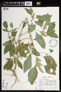 454193[1343714]Haferman, J. 1741995-09-16 United States, Minnesota, Scott, Scott Co. T115N R22W S36 SW of SW. Approx. 0.1 mi N-NE of intersection of State Hwy.13 and Co. Road 44 on N side of high Scott Co. T115N R22W S36 SW of SW. Approx. 0.1 mi N-NE of intersection of State Hwy.13 and Co. Road 44 on N side of highway.. 115N 22W 36, 44.724586 -93.409031 |
MIN:Plants | 501532[]Stevens, O. s.n.1954-09-14 United States, Minnesota, Pipestone, Pipestone Nat. Monument;Pipestone National Monument;106N;46W;, 43.979723 -96.367859 |
MIN:Plants | 524496[]Benner, J. s.n.1928-10-01 United States, Minnesota, Hennepin, Jackson Square, Mpls.;;;;, 45.010521 -93.249947 |
MIN:Plants | 541383[]Scharf, J. 301956-09-06 United States, Minnesota, Murray, State owned wetland 9 mi N and 4 mi W of Lake Wilson. Lange Marsh Transect.;;N;;, 44.126958 -96.033508 |
MIN:Plants | 542981[]Lakela, Olga 215891957-07-25 United States, Minnesota, Lake, Lake County...East of Phoebe River Tomahawk Trail;Boundary Waters Canoe Area Wilderness / Superior National Forest;063N;06W;00, 47.933219 -91.087921 |
MIN:Plants |  550212[]Moore, John; et al. 22221 United States, Minnesota, Pipestone, Pipestone County...1/2 mi north of Pipestone;;106N;46W;, 43.979723 -96.367859 |
MIN:Plants | 550293[]Cotter Tucker, Shirley 38281954-08-28 United States, Minnesota, Polk, Polk County...2 mi N of Crookston;;;;, 47.777033 -96.608121 |
MIN:Plants | 558288[]Moore, John; Hsi, Yu-tseng [Eugene] 234111957-08-07 United States, Minnesota, Blue Earth, Blue Earth Co.; S shore of Indian Lake;;108N;25W;, 44.152492 -93.828355 |
MIN:Plants | 558505[]Moore, John; Hsi, Yu-tseng [Eugene] 234601955-08-09 United States, Minnesota, Waseca, E shore of Lake Elysian;;N;;, 44.171695 -93.69741 |
MIN:Plants | 558554[]Moore, John; et al. 235501957-09-19 United States, Minnesota, Isanti, Isanti County...old house site, NW1/4 S16, Athens Twp, Cedar Creek Forest;Cedar Creek National History Area;034N;23W;16, 45.435724 -93.214819 |
MIN:Plants | 578863[]Ownbey, Gerald 33201962-08-16 United States, Minnesota, Clearwater, Itasca State Park. Douglas Lodge, S end of E arm, Lake Itasca. T143N, R36W, NE1/4 S24. Near pier below lodge;Itasca State Park;143N;36W;24, 47.188748 -95.180071 |
MIN:Plants | 585644[]Moore, John 262061962-10-03 United States, Minnesota, Houston, 3 mi SE of Caledonia;;N;;, 43.603957 -91.454353 |
MIN:Plants | 592197[]Westkaemper, Remberta s.n.1964-06-00 United States, Minnesota, Stearns, Stearns County...St. Joseph. St. Benedict's [College] farm;;124N;29W;10, 45.566172 -94.311699 |
MIN:Plants | 616826[]Moore, John; et al. 4581969-08-27 United States, Minnesota, Crow Wing, Crow Wing Natural History Area, Crow Wing County...SW1/4 S6, Garrison Twp;Crow Wing Natural Area;044N;28W;06, 46.323097 -93.926287 |
Google Map
Google Maps is a web mapping service provided by Google that features a map that users can pan (by dragging the mouse) and zoom (by using the mouse wheel). Collection points are displayed as colored markers that when clicked on, displays the full information for that collection. When multiple species are queried (separated by semi-colons), different colored markers denote each individual species.