University of Minnesota
http://www.umn.edu/
612-625-5000
http://www.umn.edu/
612-625-5000
Minnesota Biodiversity Atlas
Bell Museum
Dataset: MIN-Plants
Taxa: Equisetaceae
Search Criteria: excluding cultivated/captive occurrences
Bell Museum plants | |
 MIN:Plants |  541669[1336644]Scamman, Edith 16831940-06-19 United States, Alaska, Livengood, about 80 miles north northwest of Fairbanks., 65.900864 -148.755726 |
MIN:Plants |  533218[1336645]Abbe, Ernst C. 33811939-07-21 Canada, Quebec, Richmond Gulf, East Coast of Hudson Bay; valley of river, Wiachewn Bay |
MIN:Plants |  423554[1336646]Tryon, R.M. 49101947-08-31 Canada, Ontario, Thunder Bay, Thunder Cape. 1 mile NW of Silver Islet |
MIN:Plants |  54885[1336647]Moyer s.n.1892-07-07 Canada, Ontario, C.P.R. |
MIN:Plants |  521995[1336648]Shreve, Forrest s.n.1905-05-09 United States, Maryland, Loch Raven |
MIN:Plants |  503975[1336649]Russell, N.H. 715421954-07-01 United States, New York, Albany, easternmost inlet of Lincoln Pond; at NE part of Preserve; E.N. Huyck Preserve, Rensselaerville, 488m |
MIN:Plants |  525036[1336650]Bradley, W.E. s.n.1884-05-00 United States, Massachusetts, Brook Wilbraham |
MIN:Plants |  381782[1336651]Dudley, Margaret G. s.n.1938-10-18 Canada, Manitoba, Lake Brereton Man. |
MIN:Plants |  961044[1336652]Flett, J.B. 15241900-07-20 United States, Alaska, 16 miles W. of Nome City, 64.562732 -165.904458 |
MIN:Plants |  54901[1336653]Fallas, C.W. s.n.1897-05-09 United States, Michigan, Cedar Springs |
MIN:Plants |  568314[1336654]Abbott, R.S. s.n.1952-05-17 United States, New York, Tompkins, W. of airport, N. of Ithaca |
MIN:Plants |  548340[1336655]Ownbey, Marion 31901949-05-28 United States, Idaho, Latah, along Mannring Creek, 2 1/2 miles south of the Benewah County line, on road between Harvard and Emida |
MIN:Plants | 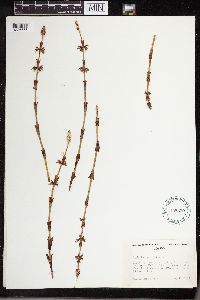 458339[1336656]Ownbey, Marion 31771949-05-15 United States, Idaho, Latah, along Ruby Creek, near junction with East Fork of Potlatch Creek, about 5 miles south of Boville, S.18, T. 40N, R.1E. |
MIN:Plants | 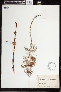 54886[1336657]Manning, Sara M. s.n.1882-05-04 United States, New Hampshire, Concord |
MIN:Plants | 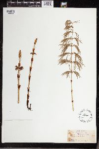 54907[1336658]Morton, J.A. s.n.1891-05-29 Canada, Ontario, Wingham |
MIN:Plants | 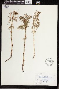 552145[1336681]Moir, D.R. 17671958-06-13 United States, North Dakota, Cavalier, above Tongue River; Olga |
MIN:Plants | 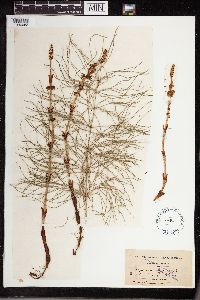 54902[1336682]Macoun, John s.n.1890-07-23 Canada, British Columbia, Revelstoke |
MIN:Plants | 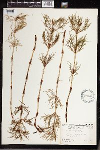 497180[1336683]Harper, Francis 35591953-07-11 Canada, Newfoundland and Labrador, Labrador: Attikamagen Lake, Iron Arm, NW. end, 54.933333 -66.65, 471m |
MIN:Plants | 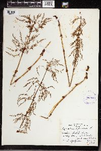 403414[1336684]Spetzman, L. s.n.1948-06-15 United States, Alaska, Anchorage, 61.218056 -149.900278 |
MIN:Plants | 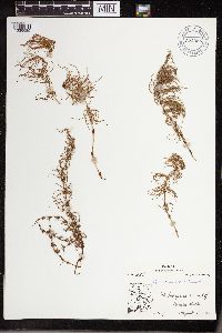 672055[1336685]Oldenburg, Margaret E. 54-5861954-08-03 Canada, Northwest Territories, Ft. Enterprise, w. end of Winter Lake; Sta. 7 |
MIN:Plants |  671515[1336686]Oldenburg, Margaret E. 54-661954-08-01 Canada, Northwest Territories, Mackenzie, Artillery Lake; Sta. 2 |
MIN:Plants |  55010[1336687]Hollinshead, Cornelia 66 United States, Wisconsin, Osceola, 45.32052 -92.70493 |
MIN:Plants |  54915[1336688]Butters, F.K. 30961915-07-08 United States, Wisconsin, N.E. of Chippewa Falls |
MIN:Plants |  388180[1336689]Wadmond, S.C. 35151901-05-30 United States, Wisconsin, Racine, Wind Point |
MIN:Plants |  15025[1336690]Hatch, Sandra 171971-05-09 United States, Wisconsin, Rusk, Sec. 36, T33N, R9W; near Clear Lake |
MIN:Plants |  812048[1336691]Bursik, R. 0131987-05-18 United States, Idaho, Bonner, Panhandle National Forest; Kaniksu Marsh Research Natural Area, ca. 8 mi south of Priest Lake, SE 1/4, NE 1/4, sec. 25 T59N R5W, 756m |
MIN:Plants |  800384[1336692]JJEV 78/191978-06-08 Canada, Yukon, Snag junction Public Campgr.; km 1913--[illegible] |
MIN:Plants |  776225[1336693]Cooper, William S. 631929-08-02 Canada, Saskatchewan, Prince Albert National Park |
MIN:Plants | 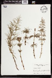 714490[1336694]Ahles, H.E. 663941967-06-07 United States, New Hampshire, Cheshire, 1.2 miles west of junction of New Hampshire Rt. 10 and 123 (Marlow) on Rt. 123, 43.115909 -72.220843 |
MIN:Plants | 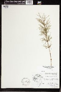 593170[1336695]Hartley, Thomas G. 77861959-07-25 United States, Wisconsin, Juneau, Hwy. 12-16 near Lyndon Station; T14N R5E S24 & 13; Lyndon Twp |
MIN:Plants | 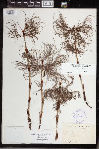 388045[1336696]Wadmond, S.C. 35151898-06-20 United States, Wisconsin, Forest, [illegible] Lake |
MIN:Plants | 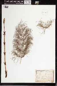 932346[1336885]Hylten-Cavallins, G.E. s.n.1886-05-00 Mexico, Vallejo [remainder illegible] |
MIN:Plants |  897083[1338026]Pacyna, A. 1976-05-13 Poland, Okocim, 20.616667 -50.95, 300m |
MIN:Plants |  766211[1338027] Switzerland, Bremgartenwald by Bern |
MIN:Plants |  54946[1338028]Schrenk 1842-00-00 |
MIN:Plants |  54547[1338029]Murray, Alex United Kingdom |
MIN:Plants |  552864[1338030]Weber, F. 1933-08-02 Czech Republic, Moravia, Vysoke Jeseniky mountains, Karlova, 900m |
MIN:Plants |  552860[1338031]Pulchart, Mir. s.n.1935-05-15 Czech Republic, Bohemia, in Piceto, Spala valley. Near Rychnov and Kneznou, 350m |
MIN:Plants |  54942[1338032]Hylten-Cavallins, G.E. 1886-07-05 Sweden |
MIN:Plants |  54944[1338033][illegible] |
MIN:Plants | 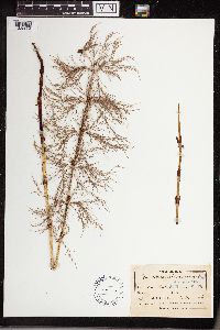 54939[1338034]Hylten-Cavallins, G.E. 1886-07-05 Sweden, Sm. Valleys |
MIN:Plants | 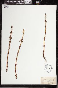 54941[1338035]Lomax, A.E. 1888-05-21 United Kingdom, Yorkshire, near Clapham |
MIN:Plants | 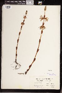 54938[1338036]Dorfler Austria, near Ried and Gnezda |
MIN:Plants | 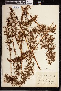 54950[1338037]Paridra, H. 1897-06-00 France, Lherm, Sardines, Alpes |
MIN:Plants |  587744[1338038]Jokela, Paavo S. 1963-06-08 Finland, Pudasjarvi, Oulu |
MIN:Plants |  341308[1338039]Gustafsson, C.E. 1911-05-26 Sweden, Vastervik, Norrlandee |
MIN:Plants |  384410[1338040] 1800-00-00 |
MIN:Plants |  260847[1338041]Jahn, J. 1908-05-19 Germany, Bohmen, Waldrand near Konradsgrund |
MIN:Plants | 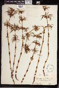 54931[1338042]Landmark, Jonas R. 1900-00-00 Norway, Flakstad, Lofoben |
MIN:Plants | 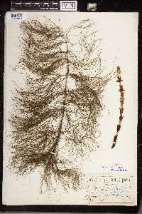 54940[1338043]Painter, W.H. s.n.1889-07-00 United Kingdom, Biddulph |
MIN:Plants | 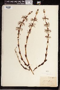 54949[1338044] s.n.1882-00-00 |
MIN:Plants | 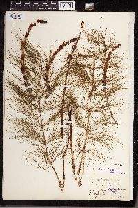 54947[1338045]Jeanpert 1893-07-00 France, Villers-Cotterets Forest |
MIN:Plants | 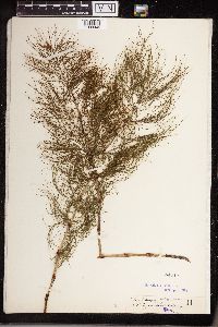 54945[1338046] Hungary |
MIN:Plants | 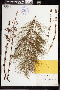 384620[1338047] 1865-08-06 Russian Federation, Novgorod |
MIN:Plants | 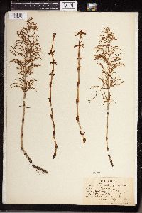 54932[1338048]Bagenholm, Gosta 1896-05-00 Sweden, Gyesta and Laugbro in Neke |
MIN:Plants | 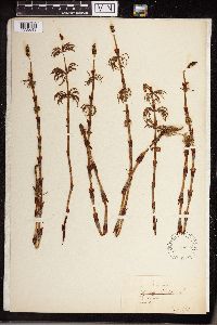 54933[1338049]Ryder 1910-06-00 Sweden, Skofds |
MIN:Plants |  341311[1338050]Issen, P.A. 1914-07-13 Sweden, Osterg, Haradshammar, Shogsallmannengen |
MIN:Plants |  341312[1338051]Hjertman, Ernst s.n.1915-06-00 Sweden, Goteborg, Anggarden |
MIN:Plants |  54935[1338052]Semler, Karl 1897-02-18 Germany, Schmausenbuck by Nurnburg |
MIN:Plants |  54934[1338054]Schulz, Paul F.F. 1901-06-13 Germany, Tpandan: Hadtheide |
MIN:Plants |  54943[1338057] Sweden |
MIN:Plants |  54936[1338058]Kaulfuss, T. 1901-05-29 Germany, Bavaria, Kersbach near Vorimbergam |
MIN:Plants |  54937[1338059]Kaulfuss, T. 1901-06-18 Germany, Bavaria, Vorimbergen |
MIN:Plants |  54948[1338582][illegible] 1885-04-29 Austria, Rind in Lufusbinaysufuf Suiful? |
MIN:Plants |  962769[1346394]Pilla, Na. J. s. n.2019-05-27 United States, Minnesota, Kanabec, 2925 Ivory Street at Farnum property, 46.012764 -93.335516 |
MIN:Plants |  965282[1375951]Lee, Michael MDL52192010-06-24 United States, Minnesota, Cook, Boundary Waters Canoe Area Wilderness, Rolling bedrock terrain northwest of Eagle Mountain, 15 miles northwest of Grand Marais. T63N R2W SE1/4 of SW1/4 of SW1/4 Sec. 27, 47.90582154 -90.57128856, 600m |
MIN:Plants |  973473[1397027]Lee, Michael MDL57292011-08-30 United States, Minnesota, Lake, Boundary Waters Canoe Area Wilderness; Rugged bedrock terrain along the Canadian border, 34 miles east-northeast of Ely, on the ridge between the North and South Arms of Knife Lake., 48.1071382 -91.18476413, 436m |
MIN:Plants |  974396[1396760]Smith, Welby R WRS361312019-05-10 United States, Minnesota, Pine, Banning State Park. On the west side of the Kettle River about 5.9 km (3.6 miles) NNE of the approximate center of Sandstone at a heading of 26 degrees., 46.17878 -92.83405 |
MIN:Plants | 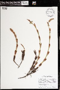 974339[1396703]Smith, Welby R WRS361492019-05-20 United States, Minnesota, Pine, Banning State Park. On the west side of the Kettle River about 4.4 km (2.7 miles) southwest of Askov at a heading of 246 degrees., 46.172037 -92.834329 |
MIN:Plants | 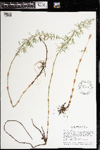 974369[1396733]Smith, Welby R WRS362092019-06-16 United States, Minnesota, Lake, In the Boundary Waters Canoe Area Wilderness, Superior National Forest. About 45 km (28 miles) east of the approximate center of Ely at 86 degrees. In a Thuja swamp at the NW end of Insula Lake., 47.92609 -91.26321 |
MIN:Plants | 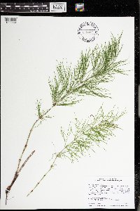 974469[1396833]Smith, Welby R WRS365422019-09-10 United States, Minnesota, Aitkin, Pliny State Wildlife Management Area. About 32 km (20 miles) S-SE of McGregor at a heading of 164 degrees., 46.33161 -93.19705 |
MIN:Plants | 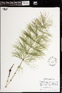 974300[1396664]Smith, Welby R WRS365552019-09-10 United States, Minnesota, Aitkin, Woross State Wildlife Management Area. About 16.5 km (10.2 miles) south of McGregor at a heading of 176 degrees., 46.45858 -93.29195 |
MIN:Plants |  976083[1373636]Smith, Welby R WRS367562020-07-13 United States, Minnesota, Itasca, Chippewa National Forest, about 21 km (13 miles) northwest of the town of Deer River., 47.469724 -93.982933 |
MIN:Plants |  977630[1401218]Anderson, Derek S. 37482021-10-05 United States, Minnesota, Aitkin, Solana State Forest. About 5.3 km northeast of Dads Corner (intersection of State Hwy. 65 and Cty. Rd. 2). Approximately 500 m west of the end of East White Pine Forest Road., 46.3647 -93.20999 |
MIN:Plants |  977642[1401230]Anderson, Derek S. 37552021-10-05 United States, Minnesota, Kanabec, Snake River State Forest. About 8.7 km east-northeast of Woodland. Approximately 900 m east of where Chelsey Brook crosses Chelsey Brook Forest Road., 46.12811 -93.17233 |
MIN:Plants |  977570[1401157]Anderson, Derek S. 35332021-06-07 United States, Minnesota, Mille Lacs, Mille Lacs WMA. About 8 km southeast of Onamia. About 860 m southeast of the intersection of 320th St. and 100th Ave., 46.00716 -93.61109 |
MIN:Plants |  977662[1401250]Anderson, Derek S. 37832021-10-29 United States, Minnesota, Carlton, Fond du Lac State Forest. About 8.7 km southeast of Cromwell. About 4 km south of the intersection of State Hwy 210 and Kettle Lake Rd. At the end of Kettle Lake Rd., 46.64098 -92.78396 |
MIN:Plants |  Equisetum pratense Ehrhart 907193[1333195]Smith, Welby 308932008-06-12 United States, Minnesota, Benton, Benton County...Wisneski State Wildlife Management Area, about 5 miles east of Rice...T38N R30W SW1/4 of SW1/4 of Sec 29;Wisneski Wildlife Area;038N;30W;29, 45.7530556 -94.1077778 |
MIN:Plants |  Equisetum pratense Ehrhart 906516[1333217]Smith, Welby 310082008-07-09 United States, Minnesota, Aitkin, Hill River State Forest. Aitkin County...About one mile north-northwest of Washburn Lake and 6 miles east of Hill City...T52N R25W NW1/4 of SE1/4 of Sec 14. 052N 25W 14, 46.9911111 -93.4725 |
MIN:Plants |  Equisetum pratense Ehrhart 561047[1333179]Scott, P. 13882002-08-16 United States, Minnesota, Lake, LAKE CO ... Ottertrack Lake, BWCAW. T66N R6W sec. 33 SENWNW.;Boundary Waters Canoe Area Wilderness / Superior National Forest;066N;06W;33, 48.158302 -91.125201 |
MIN:Plants |  Equisetum pratense Ehrhart 904439[1333218]Smith, Welby 283071999-09-10 United States, Minnesota, Pine, Pine County ... Banning State Park, about 3 miles SW of Askov ... T43N R20W NE1/4 of SW1/4 of Sec 35;Banning State Park;043N;20W;35, 46.1630556 -92.8383333 |
MIN:Plants |  Equisetum pratense Ehrhart 510867[1305991]Gerdes, Lynden 30931998-08-06 United States, Minnesota, Cook, Superior National Forest. T65N R04W S26NWSW. Cook County ... Superior National Forest. Roadside; SE of the Gunflint Trail (Hwy. 12) & Cty. 47 (Round Lake road) junction.. 065N 04W 26, 47.991796 -89.998638 |
MIN:Plants |  Equisetum pratense Ehrhart 907077[1333175]Smith, Welby 309982008-07-09 United States, Minnesota, Beltrami, Leech Lake Indian Reservation / Pennington Bog Scientific Natural Area. Beltrami County...Pennington Bog State Scientific and Natural Area, about 19 miles east of Bemidji...T146N R30W SE1/4 of NW1/4 of sec 3. 146N 30W 3, 47.4947222 -94.4733333 |
MIN:Plants |  Equisetum pratense Ehrhart 472883[1305998]Lee, Michael MDL12321996-06-03 United States, Minnesota, Wabasha, Dorer Memorial Hardwood State Forest. Wabasha Co.; Valley of West Indian Creek 5 miles NNE of Plainview; along base of 230ft, north-facing slope; At mouth of large tributary valley entering from the east; T109N R11W SW1/4 NW1/4 NE1/4 Sec. 21. 109N 11W 21, 44.331645 -92.326458 |
MIN:Plants |  Equisetum pratense Ehrhart 494042[1305996]Lee, Michael MDL24691998-09-16 United States, Minnesota, Stearns, Stearns Co.; Along the Mississippi River on the south side of St. Cloud; T124N R28W SE1/4 of NW1/4 Sec. 36;;124N;28W;36, 45.507784 -94.149738 |
MIN:Plants |  Equisetum pratense Ehrhart 911553[1333236]Smith, Welby 287632000-07-21 United States, Minnesota, Pine, Pine County...St. Croix State Park; where Sand Creek joins the St. Croix River...T 40N R 18W SE1/4 of SW1/4 of Sec 19;Saint Croix State Park;040N;18W;19, 45.9322222 -92.64 |
MIN:Plants |  Equisetum pratense Ehrhart 912874[1333172]Smith, Welby 241971994-05-31 United States, Minnesota, Koochiching, Franz Jevne State Park. Koochiching County...Franz Jevne State Park. In the Rainy River Valley, about 2 miles northeast of Birchdale... T 160N R 27W SW1/4 of SW1/4 of Sec 26. 160N 27W 26, 48.6427778 -94.0783333 |
MIN:Plants |  Equisetum pratense Ehrhart 915917[1333216]Smith, Welby 314002009-08-27 United States, Minnesota, Cook, Boundary Waters Canoe Area Wilderness / Superior National Forest. Cook County...Boundary Waters Canoe Area Wilderness, Superior National Forest. At the east end of Winchell Lake... T 64N R 2W SE1/4 of SE1/4 of Sec 26. 064N 02W 26, 47.9936111 -90.5369444 |
MIN:Plants |  Equisetum pratense Ehrhart 515446[1333176]Lee, Michael MDL38772004-09-09 United States, Minnesota, Todd, Burleene WMA. TODD COUNTY ... Burleene State Wildlife Management Area ... Three miles east-southeast of Rose City ... T130N R35W SE1/4 of NW1/4 of SW1/4 Sec.16. 130N 35W 16, 46.053652 -95.116228 |
MIN:Plants |  Equisetum pratense Ehrhart 917074[1333210]Gerdes, Lynden 59292009-09-11 United States, Minnesota, Cook, Superior National Forest. T64N R03E S11NWNW. Cook County, MN. Superior National Forest. Royal River corridor. approximately 0.19 miles WSW of the western portion of Royal Lake...NAD 83 / 721082 / 5326113. 064N 03E 11, 48.0497222 -90.0330556 |
MIN:Plants |  Equisetum pratense Ehrhart 281290[1333187]Moyle, J. 4981931-07-06 United States, Minnesota, Clearwater, Itasca Park; Clearwater Co. NE-SW-1 T143 R36;Itasca State Park;143N;36W;1, 47.232294 -95.180237 |
MIN:Plants |  Equisetum pratense Ehrhart 352800[1333192]Benner, F.R. 5811929-07-27 United States, Minnesota, Cook, Grand Portage;Grand Portage Indian Reservation / North Shore;063N;06E;, 47.9667 -89.7667 |
MIN:Plants |  Equisetum pratense Ehrhart 358808[1333193]Benner, F.R. 5811929-07-29 United States, Minnesota, Cook, 1 mi E of Grand Portage, Cook Co.;Grand Portage Indian Reservation / North Shore;063N;06E;, 47.963774 -89.663197 |
MIN:Plants |  Equisetum pratense Ehrhart 372856[1333230]Moore, John 143711941-06-14 United States, Minnesota, Polk, Polk County...1-1/2 mi SW of Fertile;Agassiz Dunes Scientific Natural Area;147N;44W;, 47.51564 -96.31032 |
MIN:Plants |  Equisetum pratense Ehrhart 381427[1333139]Moore, John 156941942-09-24 United States, Minnesota, Fillmore, 1 1/2 mi NW of Wycoff, Fillmore Co.;Dorer Memorial Hardwood State Forest;103N;12W;, 43.718601 -92.256548 |
MIN:Plants |  Equisetum pratense Ehrhart 381574[1333154]Moore, John 143011942-05-16 United States, Minnesota, Pine, Crooked Creek, 18 mi E of Hinckley, Pine Co.;;N;;, 46.027989 -92.546616 |
MIN:Plants |  Equisetum pratense Ehrhart 381662[1333140]Moore, John 152271942-05-23 United States, Minnesota, Beltrami, Red Lake Village, Beltrami Co.;Red Lake Indian Reservation;;;, 47.830961 -95.010074 |
MIN:Plants |  Equisetum pratense Ehrhart 381684[1333229]Moore, John 155681942-06-28 United States, Minnesota, Polk, 3/4 mi E of Fertile, along creek, Polk Co.;;N;;, 47.528563 -96.224087 |
MIN:Plants |  Equisetum pratense Ehrhart 387858[1333138]Moore, John 198721947-10-03 United States, Minnesota, Fillmore, Fillmore Co. 2 1/2 mi NW of Wykoff;Dorer Memorial Hardwood State Forest;103N;12W;, 43.722548 -92.289474 |
MIN:Plants |  Equisetum pratense Ehrhart 387859[1333147]Moore, John 195101947-06-11 United States, Minnesota, Itasca, Itasca Co.; 12 1/2 mi S of Grand Rapids;;N;;, 47.056221 -93.530214 |
Google Map
Google Maps is a web mapping service provided by Google that features a map that users can pan (by dragging the mouse) and zoom (by using the mouse wheel). Collection points are displayed as colored markers that when clicked on, displays the full information for that collection. When multiple species are queried (separated by semi-colons), different colored markers denote each individual species.