University of Minnesota
http://www.umn.edu/
612-625-5000
http://www.umn.edu/
612-625-5000
Minnesota Biodiversity Atlas
Bell Museum
Dataset: MIN-Plants
Taxa: Equisetaceae
Search Criteria: excluding cultivated/captive occurrences
Bell Museum plants | |
 MIN:Plants | 334699[1331643]Anonymous [poss. R.C. Perry] s.n.1885-06-00 United States, Minnesota, Washington, Dellwood, Washington Co.;;030N;21W;, 45.089966 -92.972266 |
MIN:Plants | 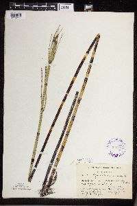 336483[1331552]Smith, L.L. 2001936-08-11 United States, Minnesota, Itasca, Itasca Co, North Star Lake, T59 R26.;Chippewa National Forest;059N;26;, 47.555117 -93.663784 |
MIN:Plants | 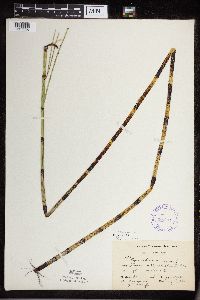 338364[1331530]Smith, L.L. 1991936-08-11 United States, Minnesota, Itasca, Itasca Co, North Star Lake;Chippewa National Forest;N;;, 47.555117 -93.663784 |
MIN:Plants | 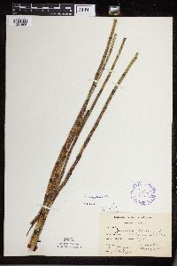 338365[1331506]Moore, W. V6041936-07-21 United States, Minnesota, Lake, Lake Co. Greenwood Lake;Superior National Forest;058N;10W;00, 47.518701 -91.63254 |
MIN:Plants | 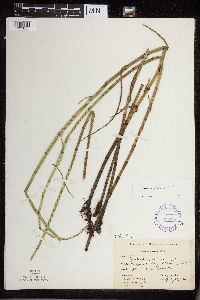 338366[1331657]Moore, W. V7221936-07-23 United States, Minnesota, Saint Louis, St. Louis Co. Cloquet River, Sec.3.;;N;;, 46.950537 -92.407122 |
MIN:Plants | 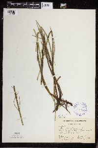 338369[1331658]Moore, W. V7051936-07-22 United States, Minnesota, Saint Louis, St. Louis Co. Cloquet River, Sec.11[?];;N;;, 46.950537 -92.407122 |
MIN:Plants | 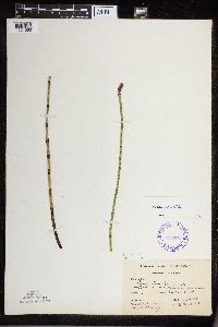 338370[1331560]Moore, W. V4081936-07-16 United States, Minnesota, Lake, Lake Co. Little Isabella, Sec.III;Superior National Forest;N;;, 47.6167 -91.35 |
MIN:Plants | 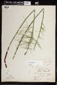 354309[1331621]Moyle, J. 5821931-07-21 United States, Minnesota, Clearwater, Itasca Park. Clearwater Co. SE-NE-3 T143 R36;Itasca State Park;143N;36W;3, 47.231738 -95.223294 |
MIN:Plants | 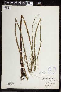 354823[1331660]Barrows, Vera 1041939-07-14 United States, Minnesota, Saint Louis, Higgins swamp. Virginia.;;N;;, 47.52326 -92.536571 |
MIN:Plants |  361023[1331537]Lakela, Olga 37721940-07-20 United States, Minnesota, Saint Louis, St. Louis County...Off St. Louis River at Fond du Lac;;048N;15W;, 47.102709 -92.707208 |
MIN:Plants |  362752[1331503]Lakela, Olga 35881940-06-29 United States, Minnesota, Saint Louis, Oatka Beach Addition, Minnesota Point, St. Louis Co, Duluth;Minnesota Point;049N;13W;18, 46.783273 -92.106579 |
MIN:Plants |  364483[1331599]Moyle, J. 34981940-06-25 United States, Minnesota, Lake, Lake Co. Knife River.;;N;;, 46.946524 -91.794017 |
MIN:Plants |  376010[1331604]Dahl, A. s.n.1937-05-11 United States, Minnesota, Scott, Savage, Scott Co.;;115N;21W;, 44.753049 -93.361742 |
MIN:Plants | 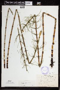 386011[1331673]Lakela, Olga 58021944-06-30 United States, Minnesota, Saint Louis, Oatka Beach Addition, Minneasota Point, Duluth.;;N;;, 46.783273 -92.106579 |
MIN:Plants | 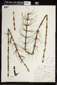 387817[1331671]Lakela, Olga 58021944-06-30 United States, Minnesota, Saint Louis, Oatka Beach Addition, Minnesota Point, Duluth;Minnesota Point;049N;13W;18, 46.783273 -92.106579 |
MIN:Plants | 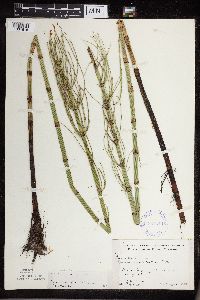 387818[1331615]Moore, John 167171944-08-01 United States, Minnesota, Aitkin, Aitkin Co. Hwy.169, 1 1/2 mi E of Aitkin;;N;;, 46.535135 -93.668897 |
MIN:Plants | 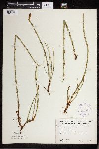 387819[1331488]Moore, John 196351947-06-19 United States, Minnesota, Kandiyohi, Kandiyohi Co. 3 mi W of New London.;;N;;, 45.301059 -95.005938 |
MIN:Plants |  387820[1331566]Schuster, R. 60211947-07-12 United States, Minnesota, Cook, Cook Co. At SW end of Clearwater Lake.;Boundary Waters Canoe Area Wilderness / Superior National Forest;065N;01E;, 48.06841 -90.379235 |
MIN:Plants |  387821[1331703]Butters, F.K. 1111936-06-24 United States, Minnesota, Cook, Cook Co. Rove Lake. T65N R1E.;Boundary Waters Canoe Area Wilderness / Superior National Forest;065N;01E;, 48.094249 -90.361715 |
MIN:Plants |  387822[1331702]Dahl, A. 1601945-06-21 United States, Minnesota, Cook, Cook Co. Loon Lake near dock.;Superior National Forest;065N;03W;, 48.077421 -90.693622 |
MIN:Plants |  387823[1331559]Moore, John 175281945-06-29 United States, Minnesota, Isanti, Isanti Co. 4.5 mi N of Cambridge.;;;;, 45.6379 -93.224392 |
MIN:Plants |  387824[1331694]Rosendahl, C. s.n.1942-05-26 United States, Minnesota, Scott, Near bridge over creek; 3/4 mi W of Savage;;N;;, 44.764689 -93.377129 |
MIN:Plants |  387825[1331696]Lakela, Olga 63381946-06-16 United States, Minnesota, Cook, Hwy.61 near Tofte, Cook Co.;North Shore / Superior National Forest;059N;04W;, 47.57379 -90.836259 |
MIN:Plants |  387826[1331704]Moore, John 185701946-06-11 United States, Minnesota, Itasca, Itasca Co. North Star Lake, 5 mi S of Marcell.;Chippewa National Forest;N;;, 47.555117 -93.663784 |
MIN:Plants |  387827[1331610]Lakela, Olga 64151946-07-13 United States, Minnesota, Cook, Hwy.61, near Schroeder, Cook Co.;North Shore / Superior National Forest;058N;04W;, 47.544347 -90.891818 |
MIN:Plants | 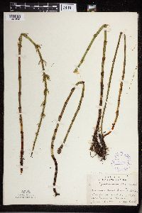 387828[1331542]Lakela, Olga 68721947-06-28 United States, Minnesota, Saint Louis, On #9 between Duluth and Fish Lake. St. Louis Co.;;N;;, 46.786672 -92.100485 |
MIN:Plants | 387829[1331644]Carlander, K. s.n.1938-07-02 United States, Minnesota, Washington, Washington Co. Echo Lake;;030N;21W;17, 45.085798 -92.960873 |
MIN:Plants | 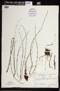 393237[1331628]Ownbey, Gerald 10631948-08-14 United States, Minnesota, Cook, Cook Co. NE end of Belle Rose Island, Susie Islands near Grand Portage;North Shore / Susie Islands, The Nature Conservancy;063N;07E;, 47.970002 -89.582363 |
MIN:Plants | 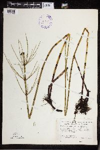 393241[1331622]Ownbey, Gerald 11111948-08-16 United States, Minnesota, Cook, Cook Co. At midcenter of Long Island, Susie Islands near Grand Portage;North Shore / Susie Islands, The Nature Conservancy;063N;07E;, 47.971381 -89.585796 |
MIN:Plants | 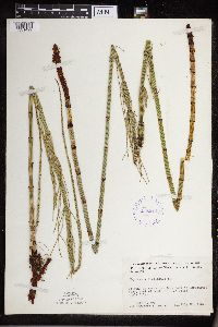 413644[1331499]Moore, John 109961939-07-20 United States, Minnesota, Lake of the Woods, Lake of the Woods Co. W of mouth of Pine Creek, Angle Inlet;Northwest Angle;168N;34W;29, 49.331104 -95.071754 |
MIN:Plants | 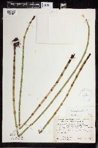 419269[1331691]Schuster, R. s.n.1948-06-26 United States, Minnesota, Cook, Cook Co. 4-5 mi N of Cook-Lake Co. line, on Rt.65 [rt.61];Finland State Forest / North Shore;058N;05W;, 47.989069 -90.55 |
MIN:Plants | 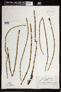 419614[1331539]Lakela, Olga 103641950-06-13 United States, Minnesota, Saint Louis, Railroad tracks, #53, Ash River area, St. Louis Co.;Kabetogama State Forest;N;;, 48.067683 -92.696346 |
MIN:Plants | 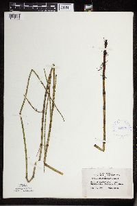 420728[1331536]Lakela, Olga 116011950-08-21 United States, Minnesota, Saint Louis, Crooked Lake, near Curtain Falls, St. Louis Co.;Boundary Waters Canoe Area Wilderness / Superior National Forest;066N;12W;, 48.236564 -91.906242 |
MIN:Plants | 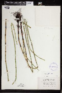 421111[1331538]Lakela, Olga 108661950-07-27 United States, Minnesota, Lake, Hwy.61, near Larsmont, Lake Co.;;N;;, 46.979102 -91.745732 |
MIN:Plants |  421240[1331613]Lakela, Olga 120351950-09-06 United States, Minnesota, Saint Louis, Hwy.216, E of Hibbing, St. Louis Co.;;N;;, 47.424661 -92.711487 |
MIN:Plants |  421744[1331618]Ahlgren, Clifford 10491950-08-22 United States, Minnesota, Saint Louis, St. Louis Co. Bay 1/4 mi SW of Curtain Falls, Crooked Lake;Boundary Waters Canoe Area Wilderness / Superior National Forest;066N;12W;, 48.208387 -91.855151 |
MIN:Plants |  425843[1331479]Emanuel, J. 5131951-06-28 United States, Minnesota, Winona, Winona Co. 1/2 mi W of the Prairie Island Bridge vic of Winona.;;N;;, 44.0667 -91.710079 |
MIN:Plants |  426913[1331573]Smith, Welby 211581992-07-31 United States, Minnesota, Le Sueur, Le Sueur Co.; at the S end of Fish Lake, about 2 mi N of Elysian; T109N R24W SE1/4 of SE1/4 of Sec 23;;109N;24W;23, 44.2272224 -93.6699982 |
MIN:Plants | 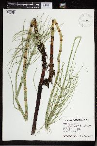 430438[1331486]Smith, Welby 132641987-06-29 United States, Minnesota, Washington, Washington Co.; Corries Swamp, large wetland about 8 miles west of Marine on St. Croix; NW1/4 SE1/4 section 26 T 32N R 21W. 032N 21W 26, 45.2161102 -92.9244461 |
MIN:Plants | 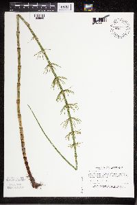 440151[1305960]Myhre, K. 38231993-06-10 United States, Minnesota, Pine, Sandstone National Wildlife Refuge. Pine Co. Located 2.5 mi S of the Sandstone Federal Correctional Institution; escarpment of Kettle River; T41N R20W NE1/4 Pine Co. Located 2.5 mi S of the Sandstone Federal Correctional Institution; escarpment of Kettle River; T41N R20W NE1/4 of NW1/4 of Sec 3.. 041N 20W 3, 46.130343 -92.865853 |
MIN:Plants | 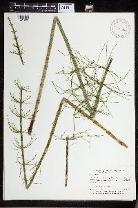 443847[1331555]Myhre, K. 51811994-07-18 United States, Minnesota, Itasca, Itasca Co.; Located one mile east of Rice Lake; T 148N R 26W SW1/4 of SE1/4 of sec 6;Chippewa National Forest / Leech Lake Indian Reservation;148N;26W;6, 47.660487 -94.019977 |
MIN:Plants | 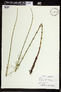 444579[1331515]Myhre, K. 55321995-06-13 United States, Minnesota, Aitkin, Aitkin Co.; Located 3 miles southeast of Big Sandy Lake; Camp Lake; T 49N R 23W SW1/4 of NW1/4 of Sec 13;Savanna State Forest;049N;23W;13, 46.731105 -93.202145 |
MIN:Plants | 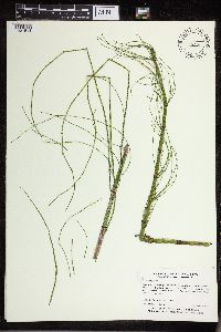 445236[1331514]Myhre, K. 6267A1995-09-07 United States, Minnesota, Aitkin, Savanna Portage State Park. Aitkin Co.; Located in Savana [sic] Portage State Park, 1.2 miles northeast of park headquarters. Plants occur along the Aitkin Co.; Located in Savana [sic] Portage State Park, 1.2 miles northeast of park headquarters. Plants occur along the northwest shore of Shumway Lake; T 50N R 22W SE1/4 of SE1/4 of sEc 8. 050N 22W 8, 46.826512 -93.147801 |
MIN:Plants | 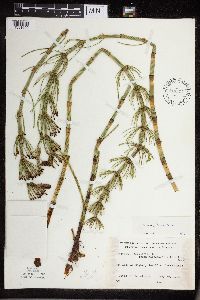 448547[1331600]Bierhorst, D. s.n.1952-05-29 United States, Minnesota, Ramsey, Ramsey Co. On side of Highway 96-100 [sic] at Sucker Lake.;Snail Lake Vadnais Lake County Park;030N;22W;19, 45.0783 -93.09564 |
MIN:Plants | 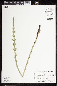 453083[1305956]Smith, Welby 115301986-05-26 United States, Minnesota, Goodhue, Goodhue Co. Perched Valley State Wildlife Area, about 4 mi W of Frontenac. NW1/4 SW1/4 sec 8, T112N R13W;Perched Valley Wildlife Management Area;112N;13W;8, 44.5172234 -92.4063873 |
MIN:Plants | 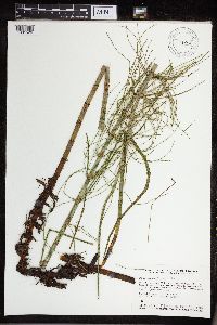 453445[1331526]Smith, Welby 130621987-06-18 United States, Minnesota, Pine, Pine County...In the St. Croix River Valley, about 7 miles southeast of Pine City...70 ft. above the floodplain; NE1/4 NE1/4 section 21, T 38N R 20W. 038N 20W 21, 45.7722222 -92.8411111 |
MIN:Plants |  453447[1331525]Smith, Welby 130801987-06-19 United States, Minnesota, Washington, Washington Co.; About 7 miles west of Marine on St. Croix; NW1/4 NE1/4 section 2, T 31N R 21W;;031N;21W;2, 45.207222 -92.9238892 |
MIN:Plants |  456639[1331478]Smith, Welby 131591987-06-26 United States, Minnesota, Washington, Washington County ... on the E side of Highway 4, about 1/2 mile NW of Marine on St. Croix ... about 150 feet above the floodplain of the St. Croix River; SW1/4 NE1/4 sec.1, T31N R20W. 031N 20W 1, 45.2061119 -92.7797241 |
MIN:Plants |  458819[1331491]Smith, Welby 147131988-08-04 United States, Minnesota, Benton, Benton Co.; Wisneski State Wildlife Management Area, about 5 miles due east of Rice; SE1/4 SE1/4 sec.30, T 38N R 30W;Wisneski Wildlife Area;038N;30W;30, 45.753334 -94.1166687 |
MIN:Plants |  460511[1331688]Myhre, K. 54661995-06-04 United States, Minnesota, Aitkin, Aitkin Co.; Located 8 miles northeast of the town of Aitkin; T 48N R 26W NE1/4 of SE1/4 of Sec 22;;048N;26W;22, 46.629027 -93.6155 |
MIN:Plants |  460807[1331571]Smith, Welby 186291991-06-05 United States, Minnesota, Kandiyohi, Kandiyohi Co.; About 11 miles north of Wilmar, and one mile south of Andrew Lake; T121N R35W SE1/4 of SE1/4 of Sec 14 Kandiyohi Co.; About 11 miles north of Wilmar, and one mile south of Andrew Lake; T 121n R 35W SE1/4 of SE1/4 of Sec 14. 121N 35W 14, 45.2852783 -95.0322189 |
MIN:Plants |  462730[1331554]Lakela, Olga 147301952-07-10 United States, Minnesota, Saint Louis, St. Louis Co. Cranberry Bay of Rainy Lake;Voyageurs National Park;N;;, 48.443479 -92.725488 |
MIN:Plants |  462945[1331568]Lakela, Olga 143831952-06-21 United States, Minnesota, Saint Louis, St. Louis Co. At Namakan Narrows, Namakan Lake.;Voyageurs National Park;N;;, 48.4781 -92.770305 |
MIN:Plants |  471805[1305952]Smith, Welby 194351991-07-10 United States, Minnesota, Koochiching, Koochiching State Forest. Koochiching Co.; On the north side of Moose Lake, about 6 miles east of Little Fork; T68N R24W SE1/4 of SE1/4 of Sec 9 Koochiching Co.; On the north side of Moose Lake, about 6 miles east of Little Fork; T 68N R 24W SE1/4 of SE1/4 of Sec 9. 068N 24W 9, 48.3922234 -93.4236145 |
MIN:Plants |  475134[1331602]Smith, Welby 11602A1986-06-03 United States, Minnesota, Olmsted, Olmsted Co. About 2 mi S-SE of Rock Dell (town) and 1/4 mi N of State Hwy.30; NW1/4 SW1/4 SE1/4 sec.16, T105N R15W;;105N;15W;16, 43.894722 -92.6255569 |
MIN:Plants |  475330[1331524]Smith, Welby 171841990-07-11 United States, Minnesota, Dodge, Wasioja Wildlife Management Area. Dodge County ... In Wasioja State Wildlife Management Area, about 4 miles west of Wasioja ... T 107N R 17W SE1/4 of SW1/4 of Sec 17. 107N 17W 17, 44.0672226 -92.8916702 |
MIN:Plants |  481220[1331659]Lakela, Olga 151601953-07-06 United States, Minnesota, Saint Louis, St. Louis Co. S28-750-R21, Prairie Lake area;;050N;21W;28, 47.582452 -92.098917 |
MIN:Plants |  491800[1331616]Lakela, Olga 165941953-08-06 United States, Minnesota, Saint Louis, St. Louis Co. Bay, Lac La Croix S of Lac La Croix Resort;Boundary Waters Canoe Area Wilderness / Superior National Forest;N;;, 48.343117 -92.144559 |
MIN:Plants | 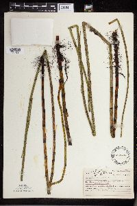 492870[1331501]Lakela, Olga 162821953-07-25 United States, Minnesota, Lake, Back Bay of Basswood Lake, Sec. 9, T64, R10. Lake Co.;Boundary Waters Canoe Area Wilderness / Superior National Forest;064N;10W;09, 48.086381 -91.635754 |
MIN:Plants | 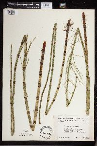 501124[1331508]Moore, John 203321949-06-28 United States, Minnesota, Marshall, Marshall Co. Tamarac River 1 mi N of Standquist;;N;;, 48.516075 -96.452079 |
MIN:Plants | 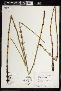 507398[1331678]Moore, John 209671951-06-06 United States, Minnesota, Aitkin, Aitkin County...At Hassman;;;;, 46.6019 -93.613022 |
MIN:Plants | 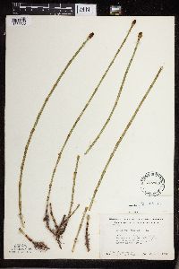 507433[1331700]Moore, John 210201951-06-09 United States, Minnesota, Itasca, Itasca County...W shore of Cedar Lake near the W boundary of Scenic State Park.;Scenic State Park;060N;25W;, 47.715773 -93.56297 |
MIN:Plants |  507578[1305957]Harris, Fred 950091995-06-16 United States, Minnesota, Carver, Carver Co.; at foot of N side of Minnesota River valley; T116 R23 NE1/4 of SE1/4 of Sec 34;;116N;23W;34, 44.810384 -93.564002 |
MIN:Plants |  508396[1305954]Smith, Welby 170271990-06-25 United States, Minnesota, Steele, Steele Co. Pogones State Wildlife Management Area, about 12 mi S-SE of Owatonna; T105N R19W NW1/4 of SE1/4 of Sec 18;Pogones Wildlife Management Area;105N;19W;18, 43.8977776 -93.2783356 |
MIN:Plants |  519622[1305958]Smith, Welby 187521991-06-11 United States, Minnesota, Aitkin, Aitkin Co.; Hill River State Forest, about 5 miles E of Hill City; T52N R25W SW1/4 of NE1/4 of Sec 23;Hill River State Forest;052N;25W;23, 46.9805565 -93.4805527 |
MIN:Plants |  525875[1331547]Lakela, Olga 190821955-08-04 United States, Minnesota, Saint Louis, St. Louis Co. Vermilion River, 4 mi above the gorge, Gold Mine Camp;Superior National Forest;N;;, 48.1741 -92.587962 |
MIN:Plants | 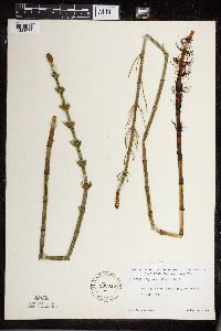 532316[1331675]Lakela, Olga 198951956-06-19 United States, Minnesota, Saint Louis, St. Louis Co. Hwy.#7, S of Fens.;;N;;, 47.589862 -92.461466 |
MIN:Plants | 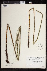 532607[1331544]Lakela, Olga 203781956-07-10 United States, Minnesota, Saint Louis, St. Louis Co. Island in Island Lake S of Hibbing, Hwy. #73;;N;;, 47.398225 -92.93797 |
MIN:Plants | 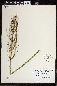 532633[1331617]Lakela, Olga 205331956-07-23 United States, Minnesota, Saint Louis, St. Louis Co. S of Fens, Wilderness Valley Farm area, Hwy.#7;;N;;, 47.589862 -92.461466 |
MIN:Plants |  536099[1331620]Wherry, E. 33691935-06-26 United States, Minnesota, Anoka, Anoka Co. Rice Lake;Rice Creek Chain of Lakes County Park;031N;23W;00, 45.128065 -93.150423 |
MIN:Plants | 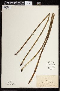 536158[1331705]Wherry, E. 32331935-06-29 United States, Minnesota, Cook, Cook Co. Ca. 1 mi NW of Clearwater Lake.;Boundary Waters Canoe Area Wilderness / Superior National Forest;065N;01E;, 48.08051 -90.366287 |
MIN:Plants |  543445[1331507]Lakela, Olga 216801957-07-26 United States, Minnesota, Lake, Lake Co. Tomahawk Trail, W of Isabella Lake;Boundary Waters Canoe Area Wilderness / Superior National Forest;062N;08W;35, 47.615814 -91.36955 |
MIN:Plants |  54602[1331510]Bergman, H. 30001914-08-06 United States, Minnesota, Hubbard, Quadrat 6, Benedict;;143N;32W;35, 47.157195 -94.695017 |
MIN:Plants |  54603[1331627]Ballard, C. B15401893-07-00 United States, Minnesota, Cass, Lake Kilpatrick, Cass Co.;;135N;29W;, 46.495108 -94.365032 |
MIN:Plants |  54604[1331681]Taylor, B. T13081892-06-00 United States, Minnesota, Chisago, Center City;;N;;, 45.389814 -92.821151 |
MIN:Plants | 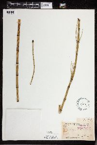 54605[1331612]Arthur, J. B1391886-07-20 United States, Minnesota, Saint Louis, Vermilion Lake;;;;, 47.891581 -92.366824 |
MIN:Plants | 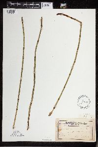 54606[1331626]Taylor, B. s.n.1892-06-00 United States, Minnesota, Chisago, Center City;;N;;, 45.389814 -92.821151 |
MIN:Plants | 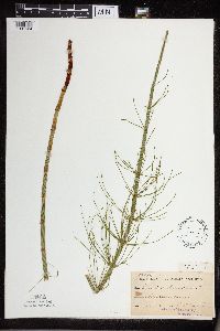 54607[1331624]Ballard, C. B1491891-06-00 United States, Minnesota, Carver, Chaska;;N;;, 44.789407 -93.602179 |
MIN:Plants | 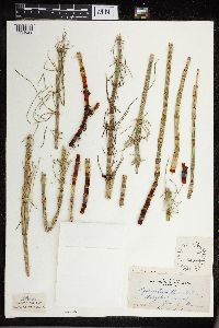 54608[1331629]Butters, F. s.n.1914-09-20 United States, Minnesota, Hennepin, Purgatory Swamp, Hennepin Co.;;N;;, 44.929685 -93.522455 |
MIN:Plants |  54609[1331550]Ballard, C. B5471891-07-00 United States, Minnesota, Scott, Spring Lake, Scott Co.;;114N;22W;, 44.706188 -93.476282 |
MIN:Plants |  54611[1331543]Ballard, C. B3621891-06-00 United States, Minnesota, Scott, Helena, Scott Co.;;113N;23W;, 44.608766 -93.55434 |
MIN:Plants |  54612[1331611]Taylor, B. T4401891-06-00 United States, Minnesota, Waseca, Lake Helma, near Janesville;;N;;, 44.116078 -93.708004 |
MIN:Plants |  54613[1331505]Sheldon, Edmund S2511891-06-00 United States, Minnesota, Le Sueur, Turtle Lake, Le Sueur Co.;;N;;, 44.3833 -93.7333 |
MIN:Plants |  54614[1331504]Taylor, B. T191891-06-00 United States, Minnesota, Le Sueur, Elysian, Le Sueur Co.;;109N;24W;, 44.461354 -93.915242 |
MIN:Plants | 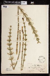 54615[1331670]Lyon, H. 7701903-05-26 United States, Minnesota, Ramsey, Fish hatchery, St. Paul.;;028N;22W;, 44.944534 -93.05372 |
MIN:Plants | 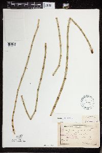 54705[1331698]Sheldon, Edmund S.24131892-06-00 United States, Minnesota, Aitkin, Farm Island Lake, Aitkin Co.;;046N;27W;00, 46.422051 -93.772021 |
MIN:Plants | 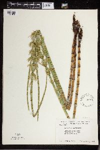 558496[1331570]Moore, John 238451958-06-11 United States, Minnesota, Kittson, Kittson Co. 1 1/2 mi NW of Lake Bronson.;;N;;, 48.750881 -96.686095 |
MIN:Plants | 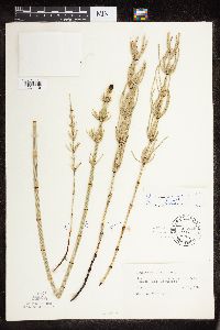 479893[1331119]Tucker, Shirley C. 3864D1955-06-19 United States, Minnesota, Clearwater, Iron Springs bog, Itasca Park;Iron Springs Bog Scientific Natural Area;144N;36W;, 47.260649 -95.244129 |
MIN:Plants | 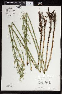 568861[1331674]Moore, John 250371960-06-17 United States, Minnesota, Kittson, Kittson Co. 9 mi N, 1/2 mi E of Lancaster.;;N;;, 48.988557 -96.793188 |
MIN:Plants | 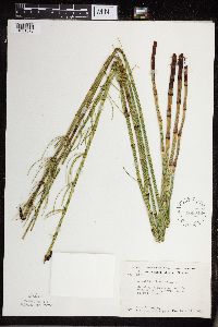 568919[1331676]Moore, John W. 251571960-07-14 United States, Minnesota, Anoka, Anoka County...Across the road along the N shore of Fish Lake;Cedar Creek National History Area;034N;23W;26, 45.402965 -93.16682 |
MIN:Plants | 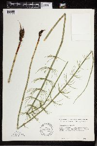 582450[1331623]Isaak, Daniel s.n.1958-00-00 United States, Minnesota, Clearwater, Clearwater Co. Itasca State Park; across the highway from the [Univ. of Minn.] biological station.;Itasca State Park;143N;36W;, 47.197458 -95.201964 |
MIN:Plants | 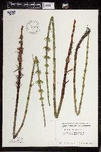 585346[1331605]Moore, John 262561963-05-21 United States, Minnesota, Blue Earth, Blue Earth Co. Along the E side of Eagle Lake;;N;;, 44.18326 -93.890909 |
MIN:Plants | 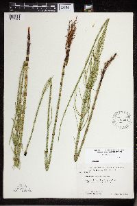 585513[1331475]Moore, John 260251962-06-06 United States, Minnesota, Houston, Houston County...4 mi NW of New Albin;Dorer Memorial Hardwood State Forest;101N;04W;, 43.544208 -91.432292 |
MIN:Plants | 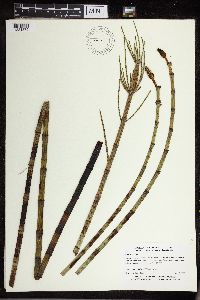 590521[1331579]Myhre, K. 58291995-07-05 United States, Minnesota, Crow Wing, Crow Wing Co.; Located 11 miles west of the town of Garrison. Plants occur along the southeast shore of South Long Lake; Crow Wing Co.; Located 11 miles west of the town of Garrison. Plants occur along the southeast shore of South Long Lake; T 44N R 30W NW1/4 of SE1/4 of Sec 23. 044N 30W 23, 46.277434 -94.090136 |
MIN:Plants | 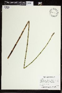 590615[1331689]Myhre, K. 57471995-06-29 United States, Minnesota, Aitkin, Aitkin Co.; Located 8 miles northwest of the town of Aitkin; northeast bay of Blind Lake; T 48N R 27W SW1/4 of SW1/4 of Aitkin Co.; Located 8 miles northwest of the town of Aitkin; northeast bay of Blind Lake; T 48N R 27W SW1/4 of SW1/4 of Sec 11. 048N 27W 11, 46.654453 -93.738039 |
MIN:Plants | 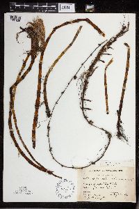 59205[1331625]Morse, Marius 301936-09-24 United States, Minnesota, Carlton, Carlton Co. Big Lake;Fond du Lac Indian Reservation;049N;18W;, 46.700429 -92.630005 |
MIN:Plants | 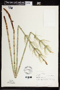 594297[1331668]Thorne, Robert 309071962-07-10 United States, Minnesota, Clearwater, Clearwater Co. Iron Springs Bog, SW1/4 Sec.28, T144N, R36W (Itasca Twp.);Iron Springs Bog Scientific Natural Area;144N;36W;28, 47.260649 -95.244129 |
MIN:Plants | 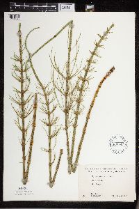 607547[1331549]Westkaemper, Remberta s.n.1963-08-00 United States, Minnesota, Stearns, Stearns Co. St. Joseph;;124N;29W;, 45.546383 -94.305394 |
MIN:Plants | 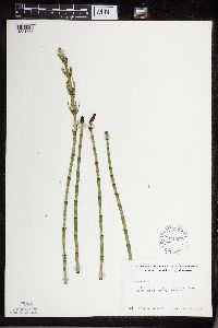 611462[1331565]Lammers, Roberta s.n.1967-06-09 United States, Minnesota, Isanti, Isanti co. Beckman Lake, Cedar Creek Natural History Area.;Cedar Creek National History Area;034N;23W;, 45.422886 -93.185916 |
MIN:Plants | 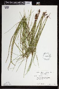 616360[1331553]Moore, John 3591969-07-23 United States, Minnesota, Crow Wing, Crow Wing Natural History Area. Crow Wing Co. E1/2 SE1/4 Sec. 6, Garrison Twp.;Crow Wing Natural Area;044N;28W;6, 46.322662 -93.926222 |
Google Map
Google Maps is a web mapping service provided by Google that features a map that users can pan (by dragging the mouse) and zoom (by using the mouse wheel). Collection points are displayed as colored markers that when clicked on, displays the full information for that collection. When multiple species are queried (separated by semi-colons), different colored markers denote each individual species.