University of Minnesota
http://www.umn.edu/
612-625-5000
http://www.umn.edu/
612-625-5000
Minnesota Biodiversity Atlas
Bell Museum
Dataset: MIN-Plants
Taxa: Lycopodiaceae
Search Criteria: excluding cultivated/captive occurrences
Bell Museum plants | |
 MIN:Plants | 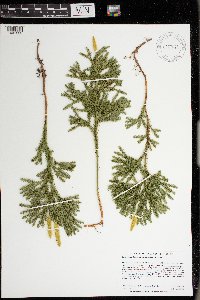 Dendrolycopodium dendroideum (Michx.) A. Haines 977645[1401233]Anderson, Derek S. 37882021-10-29 United States, Minnesota, Carlton, Sawyer WMA. About 3 km south of Sawyer. Off Cty. Rd. 7, about 3.5 km south of its intersection with State Hwy. 210. Near the carry-in access to pool/pond., 46.64442 -92.6364 |
MIN:Plants | 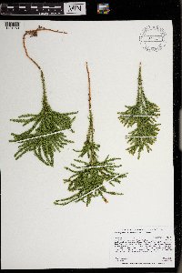 Dendrolycopodium dendroideum (Michx.) A. Haines 977572[1401159]Anderson, Derek S. 35392021-06-09 United States, Minnesota, Hubbard, Paul Bunyan State Forest. About 7.4 km west of Lake George. North of County. Rd. 95, about 1.25 km northwest of the intersection of County. Rd. 3 and County Rd. 95., 47.20317 -95.09043 |
MIN:Plants | 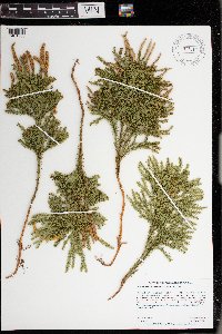 Dendrolycopodium dendroideum (Michx.) A. Haines 977612[1401200]Anderson, Derek S. 34522020-11-06 United States, Minnesota, Pine, Nemadji State Forest. About 10.5 km northwest of Cloverton. On the Park Truck Trail, about 5 km west of the intersection with the Gandy Dancer Trail., 46.25607 -92.37629 |
MIN:Plants | 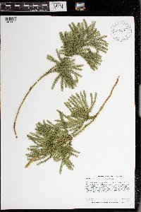 Dendrolycopodium dendroideum (Michx.) A. Haines 977600[1401188]Anderson, Derek S. 34562020-11-06 United States, Minnesota, Pine, Nemadji State Forest. About 12.2 km northwest of Cloverton. On the Park Truck Trail, about 8 km west of the intersection with the Gandy Dancer Trail., 46.26004 -92.40136 |
MIN:Plants |  Dendrolycopodium dendroideum (Michx.) A. Haines 977601[1401189]Anderson, Derek S. 34572020-11-06 United States, Minnesota, Pine, Nemadji State Forest. About 14.5 km northwest of Cloverton. On the Park Truck Trail, about 11 km west of the intersection with the Gandy Dancer Trail., 46.28239 -92.40331 |
MIN:Plants |  Dendrolycopodium dendroideum (Michx.) A. Haines 977649[1401237]Anderson, Derek S. 37812021-10-29 United States, Minnesota, Carlton, Fond du Lac State Forest. About 8.7 km southeast of Cromwell. About 4 km south of the intersection of State Hwy 210 and Kettle Lake Rd. At the end of Kettle Lake Rd., 46.64245 -92.78524 |
MIN:Plants |  Dendrolycopodium dendroideum (Michx.) A. Haines 977664[1401252]Anderson, Derek S. 37712021-10-29 United States, Minnesota, Carlton, Carlton County Forest. About 16 km southwest of Cromwell. On Sauvolz Rd, about 1.7 km west of the intersection with Erickson Rd., 46.57888 -93.03409 |
MIN:Plants |  Dendrolycopodium dendroideum (Michx.) A. Haines 977651[1401239]Anderson, Derek S. 37792021-10-29 United States, Minnesota, Carlton, Carlton County Forest. About 12.7 km southwest of Cromwell. Along trail, about 400 m northeast of Cty. Rd. 22. About 2 km southeast of intersection of Cty. Rd. 22 and Schoolhouse Rd., 46.62133 -93.02957 |
MIN:Plants | 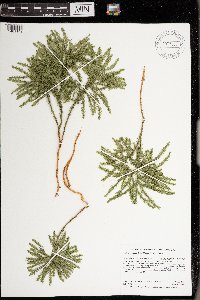 Dendrolycopodium dendroideum (Michx.) A. Haines 977555[1401142]Anderson, Derek S. 34242020-10-08 United States, Minnesota, Chisago, Carlos Avery WMA. About 1.8 km east of Stacy. About 560 m west of the intersection of Hemingway Ave. and Cty. Rd. 19., 45.39795 -92.96464 |
MIN:Plants | 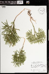 Dendrolycopodium dendroideum (Michx.) A. Haines 977556[1401143]Anderson, Derek S. 34252020-10-08 United States, Minnesota, Chisago, Carlos Avery WMA. About 4 km east-northeast of Stacy. About 470 m southwest of the Cty. Rd. 19 bridge over the Sunrise River., 45.40604 -92.937 |
MIN:Plants | 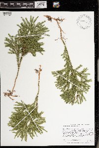 Dendrolycopodium dendroideum (Michx.) A. Haines 977558[1401145]Anderson, Derek S. 34272020-10-08 United States, Minnesota, Chisago, Carlos Avery WMA. About 4 km east-northeast of Stacy. About 470 m southwest of the Cty. Rd. 19 bridge over the Sunrise River., 45.40516 -92.93594 |
MIN:Plants | 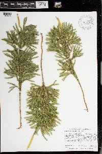 Dendrolycopodium dendroideum (Michx.) A. Haines 977628[1401216]Anderson, Derek S. 34352020-10-15 United States, Minnesota, Chisago, Carlos Avery WMA. About 3.6 km northeast of Stacy. About 900 meters northeast of the intersection of Hemmingway Ave. and 320th St., 45.41683 -92.94977 |
MIN:Plants | 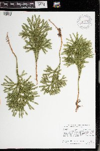 Dendrolycopodium dendroideum (Michx.) A. Haines 977626[1401214]Anderson, Derek S. 34472020-10-15 United States, Minnesota, Chisago, Carlos Avery WMA. About 3 km north-northeast of Wyoming. About 340 meters southeast of the intersection of Foxhill Ave. and 287th St., 45.3629 -92.9851 |
MIN:Plants | 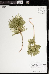 Dendrolycopodium dendroideum (Michx.) A. Haines 977534[1401121]Anderson, Derek S. 34622021-03-13 United States, Minnesota, Chisago, Carlos Avery Wildlife Management Area: Sunrise Unit. About 4.6 km northeast of Stacy. About 180 m south-southeast of the parking lot on County Road 18 (870 m east of the intersection of Hemingway Ave. and Cty. Rd. 18)., 45.42847 -92.94737 |
MIN:Plants | 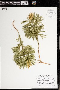 Dendrolycopodium dendroideum (Michx.) A. Haines 977533[1401120]Anderson, Derek S. 34652021-03-13 United States, Minnesota, Chisago, Carlos Avery Wildlife Management Area: Sunrise Unit. About 4.3 km northeast of Stacy. About 660 m south of the parking lot on County Road 18 (870 m east of the intersection of Hemingway Ave. and Cty. Rd. 18)., 45.42405 -92.94716 |
MIN:Plants | 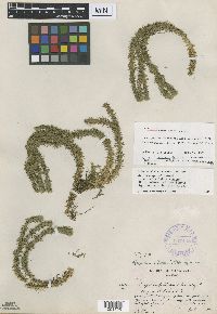 357448[1001728]Butters, F.K. 111a1938-07-11 United States, Minnesota, Cook, Cliff south of Rove Lake;Boundary Waters Canoe Area Wilderness / Superior National Forest;065N;01E;, 48.092221 -90.37664 |
MIN:Plants | 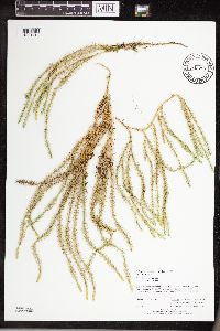 Spinulum canadense (Nessel) A. Haines 943297[1291413]Perry, Ethan F. 130212013-08-02 United States, Minnesota, Saint Louis, 3.2 miles SE of Canyon., 47.01599 -92.41307 |
MIN:Plants | 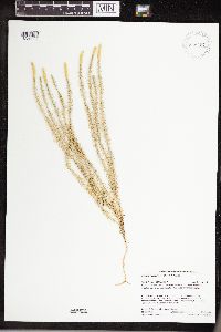 Spinulum canadense (Nessel) A. Haines 946467[1289952]Gerdes, Lynden B. 56722008-08-21 United States, Minnesota, Lake, Superior National Forest. Boundary Waters Canoe Area Wilderness. Crooked Lake area, approximately 0.02 miles NW of Frolic Lake. SWSESW of section; T065N R11W sec02, 48.139426 -91.705887 |
MIN:Plants | 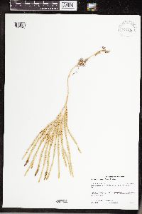 Spinulum canadense (Nessel) A. Haines 946476[1289943]Gerdes, Lynden B. 54862007-07-31 United States, Minnesota, Lake, Superior National Forest. BWCAW. Approximately 0.74 miles SW of Perent Lake. SESE of section; T061N R07W sec02, 47.793163 -91.172668 |
MIN:Plants | 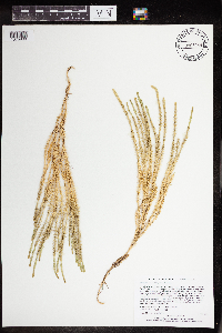 Spinulum canadense (Nessel) A. Haines 965269[1375938]Lee, Michael MDL52052010-06-23 United States, Minnesota, Cook, Boundary Waters Canoe Area Wilderness, Rolling bedrock terrain northeast of Eagle Mountain, 15 miles northwest of Grand Marais. T63N R2W W1/2 of SE1/4 of SE1/4 Sec. 23, 47.92032403 -90.53696976, 588m |
MIN:Plants | 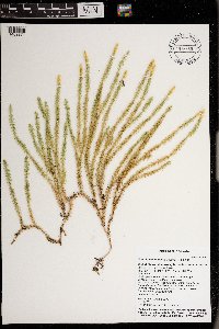 Spinulum canadense (Nessel) A. Haines 976680[1402271]Timothy J. S. Whitfeld 30022021-07-20 United States, Minnesota, St. Louis, Between Crane Lake and Dovre Lake, 48.278311 -92.4487899, 390m |
MIN:Plants | 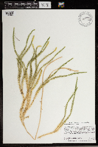 Spinulum canadense (Nessel) A. Haines 966963[1359654]Dahlberg, Nathan B. NBD1912019-08-13 United States, Minnesota, Lake, Superior National Forest. 203m NE of Thorsen Rd, 1197m NW of Sawbill Landing Rd, 25.94 miles from Winton;, 47.71 -91.35 |
MIN:Plants | 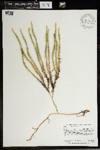 Spinulum canadense (Nessel) A. Haines 966987[1359668]Dahlberg, Nathan B. NBD2162019-09-04 United States, Minnesota, Koochiching, 825m S of County Rd 77, 1843m E of County Rd 13, 9.56 miles from Littlefork;, 48.35 -93.75 |
MIN:Plants | 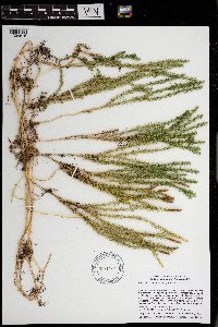 Spinulum canadense (Nessel) A. Haines 971147[1394616]Smith, Welby R WRS361132018-09-17 United States, Minnesota, Lake, Superior National Forest; about 9.7 km (6 miles) north of Isabella at a heading of 7 degrees. Approximately 70 meters NE of Forest Rd 373., 47.70355 -91.3395833 |
MIN:Plants | 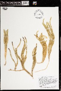 Spinulum canadense (Nessel) A. Haines 973388[1398941]Lee, Michael MDL59822012-07-04 United States, Minnesota, Lake, Boundary Waters Canoe Area Wilderness; Fairly rugged bedrock terrain southwest of Hoist Bay, Basswood Lake, 11 miles northeast of Ely; north of the Four Mile Portage., 48.0053525878 -91.653721203, 424m |
MIN:Plants | 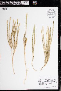 Spinulum canadense (Nessel) A. Haines 977320[1402904]Lee, Michael MDL66142014-07-27 United States, Minnesota, St. Louis, Rolling to fairly rugged terrain south of Highway 169, west-southwest of Twin Lakes, seven miles southwest of Ely., 47.84737221864 -91.98926529488, 165m |
MIN:Plants | 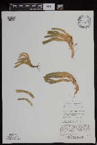 Huperzia x josephbeitellii A. Haines 498982[1295125]Lee, Michael D. MDL29322001-06-12 United States, Minnesota, Lake, On the northeast side of Moose Lake 3 1/2 miles northwest of Cramer. T59N R6W NE1/4 of SW1/4 of NE1/4 Sec. 30 [Superior National Forest], 47.562697 -91.137425 |
MIN:Plants | 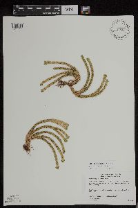 Huperzia x josephbeitellii A. Haines 477298[1295129]Gerdes, Lynden B. 41652000-07-31 United States, Minnesota, Lake, T57N R07W S13SENE. Little Marais. Section 13 Cliff feature approx 1 mile NNE of the Finland Cemetary, 47.410745 -91.110162 |
MIN:Plants | 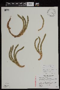 Huperzia x josephbeitellii A. Haines 489098[1295000]Gerdes, Lynden B. 43542001-06-11 United States, Minnesota, Lake, T56N R07W S07NENW. Tettegouche State Park. Silver Bay, MN. Outcrop / cliff feature visible from MicMac camp road, approximately 0.25 mile east of Cty. 4, 47.33958 -91.198054 |
MIN:Plants | 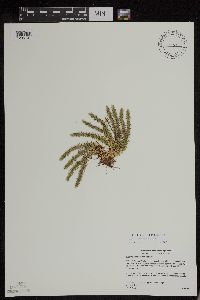 Huperzia x josephbeitellii A. Haines 477741[1295131]Gerdes, Lynden B. 40232000-07-06 United States, Minnesota, Lake, T57N R07W S24NESE. Little Marais. Small northeast-facing cliff feature approx. 1/8 mile SE of the Superior Hiking Trail and County 6 junction. Approx. 1/4 mile SE of the Finland Cemetary., 47.410745 -91.110162 |
MIN:Plants | 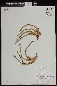 Huperzia x josephbeitellii A. Haines 477748[1295124]Gerdes, Lynden B. 4015A2000-07-06 United States, Minnesota, Lake, T57N R07W S24SWNE. Little Marais. Small northeast-facing cliff feature approx. 1/8 mile SE of the Superior Hiking Trail and County 6 junction. Approx. 1/4 mile SE of the Finland Cemetary., 47.410745 -91.110162 |
MIN:Plants | 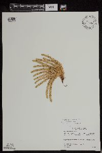 Huperzia x josephbeitellii A. Haines 477757[1295134]Gerdes, Lynden B. 43182000-09-26 United States, Minnesota, Lake, T56N R08W S06SWSE. Tettegouche State Park. Mt. Baldy, Approximately 4 miles north of Silver Bay, MN, 47.33958 -91.198054 |
MIN:Plants | 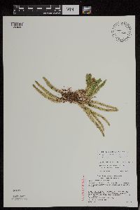 Huperzia x josephbeitellii A. Haines 489096[1294999]Gerdes, Lynden B. 44152001-07-26 United States, Minnesota, Cook, T59N R04W S01NWSW. Leveaux Mountain, Superior National Forest. Approximately 4.1 miles NE of Tofte, 47.623034 -90.777434 |
MIN:Plants | 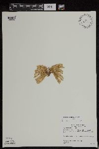 Huperzia x josephbeitellii A. Haines 477740[1295130]Gerdes, Lynden B. 43152000-09-26 United States, Minnesota, Lake, T56N R08W S06SWSE. Tettegouche State Park. Mt. Baldy, Approximately 4 miles north of Silver Bay, 47.33958 -91.198054 |
MIN:Plants | 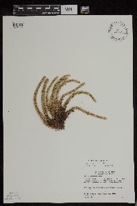 Huperzia x josephbeitellii A. Haines 480573[1295144]Gerdes, Lynden B. 4078b2000-07-17 United States, Minnesota, Lake, T56N R08W S24SESW. Tettegouche State Park, northwest of Silver Bay, MN. Long, north-facing (east-west trending) cliff feature approx. 0.31 mile north of Bean Lake., 47.33958 -91.198054 |
MIN:Plants | 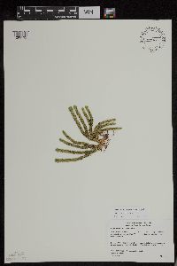 Huperzia x josephbeitellii A. Haines 477742[1295132]Gerdes, Lynden B. 41642000-07-31 United States, Minnesota, Lake, T57N R07W S13SENE. Little Marais. Section 13 Cliff feature approx 1 mile NNE of the Finland Cemetary, 47.410745 -91.110162 |
MIN:Plants | 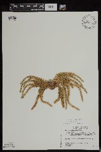 Huperzia x josephbeitellii A. Haines 480574[1295002]Gerdes, Lynden B. 4078A2000-07-17 United States, Minnesota, Lake, T56N R08W S24SESW. Tettegouche State Park, northwest of Silver Bay, MN. Long, north-facing (east-west trending) cliff feature approx. 0.31 mile north of Bean Lake., 47.33958 -91.198054 |
MIN:Plants | 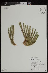 Huperzia x josephbeitellii A. Haines 455165[1295128]Gerdes, Lynden B. 40992000-07-19 United States, Minnesota, Lake, T56N R08W S25NWNW. Tettegouche State Park, northwest of Silver Bay, MN. WSW-facing cliff feature 0.15 mile north of Bean Lake. (Isolated feature south of the prominent east-west trending cliff feature to the north)., 47.33958 -91.198054 |
MIN:Plants | 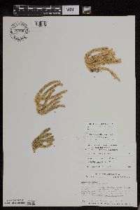 Huperzia x josephbeitellii A. Haines 728736[1295143]Coffin, B. 331980-08-22 United States, Minnesota, Cook, T65N, R1E, NW1/4, SW1/4, Sec.28. Clearwater Lake. Approx. 2 mi from west end of lake on south shore on second north-facing cliff. [Boundary Waters Canoe Area Wilderness / Superior National Forest], 48.08486 -90.335202 |
MIN:Plants | 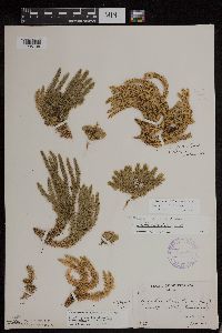 Huperzia x josephbeitellii A. Haines 357225[1295138]Butters, F.K. 841936-06-22 United States, Minnesota, Cook, First cliff on S side of Clearater Lake. Twp. 65N R. 1E [Boundary Waters Canoe Area Wilderness / Superior National Forest], 47.94014 -90.645955 |
MIN:Plants | 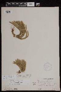 Huperzia x josephbeitellii A. Haines 357229[1295136]Butters, F.K. 94a1936-06-22 United States, Minnesota, Cook, On cliff 2b, S side of Clearwater Lake. T65N R1E. [Boundary Waters Canoe Area Wilderness / Superior National Forest], 48.087449 -90.322587 |
MIN:Plants | 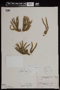 Huperzia x josephbeitellii A. Haines 387742[1295137]Schuster, R.M. 60031947-09-04 United States, Minnesota, Cook, Pigeon Point, about 1/2 mi from tip [Grand Portage Indian Reservation; T64N;R7E;S25], 47.997942 -89.538143 |
MIN:Plants | 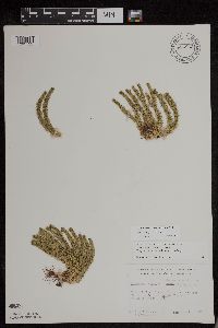 Huperzia x josephbeitellii A. Haines 684843[1295123]Meyer, Robert J. 61977-08-06 United States, Minnesota, Cook, Mouth of Pigeon River. W1/2 sec.28 T64N R7E [Grand Portage Indian Reservation], 47.9667 -89.7667 |
MIN:Plants | 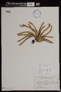 Huperzia x josephbeitellii A. Haines 393213[1295139]Ownbey, Gerald B. 11521948-08-18 United States, Minnesota, Cook, East end of Susie Island along N side of southern promentory, Susie Islands near Grand Portage [Susie Islands, The Nature Conservancy Preserve; T63N;R7E], 47.973776 -89.578978 |
MIN:Plants | 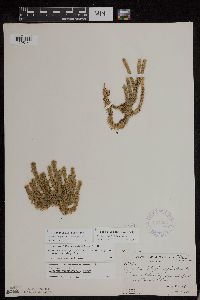 Huperzia x josephbeitellii A. Haines 357226[1295141]Butters, F.K. 654781938-07-09 United States, Minnesota, Cook, 1/2 mi E of east end of Mountain Lake. T65N;R2E [Boundary Waters Canoe Area Wilderness / Superior National Forest], 48.10737 -90.213334 |
MIN:Plants | 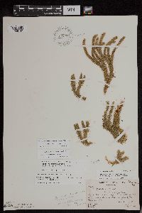 Huperzia x josephbeitellii A. Haines 661298[1295142]Butters, F.K. 246B1937-07-04 United States, Minnesota, Cook, cliffs on south side of Mountain Lake, east of portage to Clearwater Lake. Twp. 65N R. 1E [Boundary Waters Canoe Area Wilderness / Superior National Forest], 48.10737 -90.224172 |
MIN:Plants | 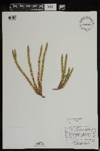 Huperzia x josephbeitellii A. Haines 508923[1295122]Lee, Michael D. MDL28022000-07-13 United States, Minnesota, Lake, cliffs overlooking the Beaver River 1-1/2 miles west of Beaver Bay. T55N R8W N1/2 of SW1/4 of SE1/4 Sec. 10, SE1/4 of NW1/4 of SE1/4 Sec. 10, 47.2577 -91.300444 |
MIN:Plants | 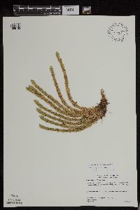 Huperzia x josephbeitellii A. Haines 477743[1295133]Gerdes, Lynden B. 43162000-09-26 United States, Minnesota, Lake, T56N R08W S06SWSE. Tettegouche State Park. Mt. Baldy, Approximately 4 miles north of Silver Bay, 47.33958 -91.198054 |
MIN:Plants |  Huperzia x josephbeitellii A. Haines 480575[1295140]Gerdes, Lynden B. 41032000-07-19 United States, Minnesota, Lake, T56N R08W S24SWSW. Tettegouche State Park, northwest of Silver Bay, MN. Long, north-facing (east-west trending) cliff feature approx. 0.31 mile north of Bean Lake., 47.33958 -91.198054 |
MIN:Plants |  Huperzia x josephbeitellii A. Haines 477759[1295135]Gerdes, Lynden B. 40212000-07-06 United States, Minnesota, Lake, T57N R07W S24NESE. Little Marais, MN. Small, north-facing cliff feature approx. 1/4 mile SE of the Superior Hiking Trail and County 6 junction. Approx. 1/2 mile SE of the Finland Cemetary., 47.410745 -91.110162 |
MIN:Plants |  Huperzia x josephbeitellii A. Haines 455102[1295127]Gerdes, Lynden B. 4106 b2000-07-19 United States, Minnesota, Lake, T56N R08W S24SWSW. Tettegouche State Park, nortwest of Silver Bay. Cliff feature approximately 0.31 mile north of Bean Lake., 47.33958 -91.198054 |
MIN:Plants |  Huperzia x josephbeitellii A. Haines 505507[1295121]Lee, Michael D. MDL3065C2001-07-18 United States, Minnesota, Lake, Along County Road 7 and the East Branch Baptism River, three miles northeast of Finland. T57N R7W S1/2 of SE1/4 of NE1/4 Sec.10., 47.374282 -91.228225 |
MIN:Plants | 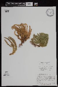 Huperzia x josephbeitellii A. Haines 498958[1295126]Lee, Michael D. MDL3069A2001-07-26 United States, Minnesota, Cook, Superior National Forest. Above the Onion River 3 1/2 miles northeast of Tofte. Atop Leveaux Mountain. T59N R4W S1/2 of SE1/4 Sec.2, 47.620737 -90.778342 |
MIN:Plants | 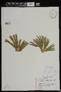 Huperzia x josephbeitellii A. Haines 489099[1295001]Gerdes, Lynden B. 43972001-07-13 United States, Minnesota, Lake, T56N R08W S25NWSW. Tettegouche State Park, Silver Bay, MN. Bean Lake cliff. Approximately 1.5 miles NW of town., 47.33958 -91.198054 |
MIN:Plants | 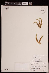 Huperzia x josephbeitellii A. Haines 946443[1289976]Gerdes, Lynden B. 61412010-08-03 United States, Minnesota, Lake, Superior National Forest. BWCAW [Boundary Waters Canoe Area Wilderness]. Midway along the NW-facing shore of Rabbit Lake. SWNE of section; T066N R06W sec34, 48.159832 -91.085619 |
MIN:Plants | 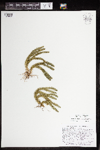 Huperzia x josephbeitellii A. Haines 964681[1375625]Lee, Michael MDL49062009-06-16 United States, Minnesota, Cook, Boundary Waters Canoe Area Wilderness, Rugged bedrock terrain along the Border Route Hiking Trail, 24 miles north of Grand Marais. T65N R1E SE1/4 of SW1/4 of NE1/4 Sec. 21, SW1/4 of SE1/4 of NE1/4 Sec. 21, 48.09953998 -90.33126083 |
MIN:Plants | 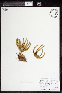 Huperzia x josephbeitellii A. Haines 965159[1375829]Lee, Michael MDL50992009-08-29 United States, Minnesota, Cook, Boundary Waters Canoe Area Wilderness, On a small island in Winchell Lake, in the bay leading to the Omega Lake portage, 22 miles northwest of Grand Marais. T64N R2W E1/2 of NE1/4 of SW1/4 Sec. 30, 47.99551086 -90.62878644 |
MIN:Plants | 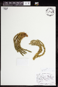 Huperzia x josephbeitellii A. Haines 965108[1375639]Lee, Michael MDL4920A2009-06-18 United States, Minnesota, Cook, Rugged bedrock terrain along the Border Route Hiking Trail, 11 miles north of Hovland. T64N R4E N1/2 of NW1/4 of NE1/4 Sec. 28 (irregular Section), 48.00084584 -89.93824711 |
MIN:Plants | 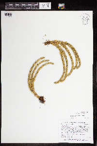 Huperzia x josephbeitellii A. Haines 964685[1375640]Lee, Michael MDL4920B2009-06-18 United States, Minnesota, Cook, Rugged bedrock terrain along the Border Route Hiking Trail, 11 miles north of Hovland. T64N R4E N1/2 of NW1/4 of NE1/4 Sec. 28 (irregular Section), 48.00084584 -89.93824711 |
MIN:Plants | 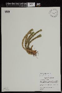 Huperzia x protoporophila A. Haines 480580[1294822]Gerdes, Lynden B. 4086b2000-07-17 United States, Minnesota, Lake, T56N R08W S24SESW. Tettegouche State Park, northwest of Silver Bay, MN. Long, north-facing (east-west trending) cliff feature 0.25-0.50 mile north of Bear and Bean Lakes., 47.33958 -91.198054 |
MIN:Plants |  Huperzia x protoporophila A. Haines 480585[1295022]Gerdes, Lynden B. 40252000-07-06 United States, Minnesota, Lake, T57N R07W S24NESE. Little Marais, MN. Small, north-facing cliff approx. 1/4 mile SE of the Superior Hiking Trail and County 6 junction. Approx. 1/2 mile SE of the Finland Cemetary., 47.410745 -91.110162 |
MIN:Plants |  Huperzia x protoporophila A. Haines 282821[1294824]Butters, F.K. 4661932-07-17 United States, Minnesota, Cook, S of Clearwater Lake. T65N, R1E [Boundary Waters Canoe Area Wilderness / Superior National Forest], 48.087449 -90.322587 |
MIN:Plants |  Huperzia x protoporophila A. Haines 357227[1294825]Butters, F.K. 94b1936-06-22 United States, Minnesota, Cook, On cliff 2b, S side of Clearwater Lake. T65 R1E [Boundary Waters Canoe Area Wilderness / Superior National Forest], 48.087449 -90.322587 |
MIN:Plants |  Huperzia x protoporophila A. Haines 357449[1294826]Burns, G.W. 3841938-08-05 United States, Minnesota, Cook, Alder Lake. T64N R1E [Boundary Waters Canoe Area Wilderness / Superior National Forest], 48.045571 -90.293351 |
MIN:Plants |  Huperzia x protoporophila A. Haines 385897[1294827]Lakela, Olga 57761944-08-14 United States, Minnesota, Lake, Pancake Island in Lake Superior, between East Beaver Bay and the Palisades [T55N;R7W], 47.2677 -91.282943 |
MIN:Plants |  Huperzia x protoporophila A. Haines 498959[1295023]Lee, Michael D. MDL30702001-07-26 United States, Minnesota, Cook, Superior National Forest. Above the Onion River 3 1/2 miles northeast of Tofte. Leveaux Mountain. T59N R4W S1/2 of SE1/4 Sec.2, 47.620737 -90.778342 |
MIN:Plants |  Huperzia x protoporophila A. Haines 387743[1294828]Schuster, R.M. s.n.1947-09-04 United States, Minnesota, Cook, Pigeon Point, about 1/2 mi from tip [Grand Portage Indian Reservation; T64N;R7E;S25], 47.997942 -89.538143 |
MIN:Plants |  Huperzia x protoporophila A. Haines 388086[1294829]Lakela, Olga 57761944-08-14 United States, Minnesota, Lake, On Pancake Island in Lake Superior between East Beaver Bay and the Palisades [T55N;R7W], 47.2677 -91.282943 |
MIN:Plants |  Huperzia x protoporophila A. Haines 462570[1294830]Lakela, Olga 159071952-10-13 United States, Minnesota, Lake, Beaver Island, Lake Superior T55N R7W S5, 47.283672 -91.254864 |
MIN:Plants |  Huperzia x protoporophila A. Haines 477306[1294821]Gerdes, Lynden B. 41392000-07-25 United States, Minnesota, Lake, T57N R07W S34NESE. Wolf Ridge Environmental Learning Center, Finland, MN. Southwest portion of the Wolf Lake cliff feature., 47.378962 -91.203696 |
MIN:Plants |  Huperzia x protoporophila A. Haines 480582[1294823]Gerdes, Lynden B. 40532000-07-13 United States, Minnesota, Lake, T57N R08W S26SWNW. Approx. 3.5 miles SW of Finland, MN. Cliff feature on the south side of Hockamin Creek. [Superior National Forest], 47.410504 -91.26732 |
MIN:Plants |  Huperzia x protoporophila A. Haines 480584[1295021]Gerdes, Lynden B. 41892000-08-02 United States, Minnesota, Lake, T56N R08W S23 [prob S24] NESE. Tettegouche State Park. Cliff feature approx. 2.25 miles NNW of Silver Bay MN and 1 miles south of Lax Lake., 47.33958 -91.198054 |
MIN:Plants | 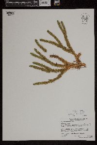 Huperzia x protoporophila A. Haines 959044[1305271]Gerdes, Lynden B. 55092007-08-14 United States, Minnesota, Lake, Superior National Forest. Approximately 9.22 miles WNW of Isabella, MN and 0.25 miles east of the Northwest Road (FR 373)., 47.74861111 -91.38555556 |
MIN:Plants | 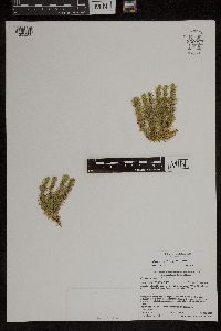 Huperzia x protoporophila A. Haines 959053[1305280]Gerdes, Lynden B. 57022008-09-15 United States, Minnesota, Saint Louis, Superior National Forest. Approximately 5.77 miles NNW of Ely, MN and 0.39 miles N of High Lake. Accessed south off of FR 460., 47.98527778 -91.86361111 |
MIN:Plants | 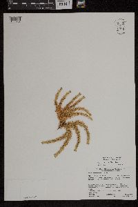 Huperzia x protoporophila A. Haines 959055[1305282]Gerdes, Lynden B. 57042008-09-15 United States, Minnesota, Saint Louis, Superior National Forest. Approximately 5.77 miles NNW of Ely, MN and 0.39 miles N of High Lake. Accessed south off of FR 460., 47.98527778 -91.86361111 |
MIN:Plants | 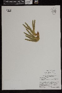 Huperzia x protoporophila A. Haines 959008[1305235]Gerdes, Lynden B. 61102010-07-17 United States, Minnesota, Cook, Superior National Forest. BWCAW. Southeast shore of Bingshick Lake., 48.08361111 -90.89111111 |
MIN:Plants |  Huperzia x protoporophila A. Haines 964729[1375675]Lee, Michael MDL4953B2009-06-25 United States, Minnesota, Cook, On the north slope of Oberg Mountain, in rugged bedrock terrain five miles northeast of Tofte. T59N R4W NE1/4 of NW1/4 of NE1/4 Sec. 1, NW1/4 of NE1/4 of NE1/4 Sec. 1, 47.62975729 -90.77224805 |
MIN:Plants |  291843[1322832]Fryklund, P. s.n.1925-04-23 United States, Minnesota, Roseau, [no further data];;;;, 48.791028 -95.795207 |
MIN:Plants |  55215[1327161]Sandberg, John s.n.1891-08-00 United States, Idaho, Kootenai, Kootenai Co. |
MIN:Plants |  536086[1322834]Wherry, E. 32361935-06-29 United States, Minnesota, Cook, Cook Co.; Clearwater Lake.;Boundary Waters Canoe Area Wilderness / Superior National Forest;065N;01E;, 48.087449 -90.322587 |
MIN:Plants | 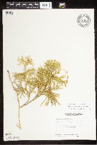 686902[1322838]Wheeler, Gerald 13281977-05-15 United States, Minnesota, Itasca, Itasca Co. Coll. Site #9; NW1/4 NW1/4 Sec.21 T55N R26W, approx. 5 mi W of Grand Rapids;;055N;26W;21, 47.237861 -93.657463 |
MIN:Plants | 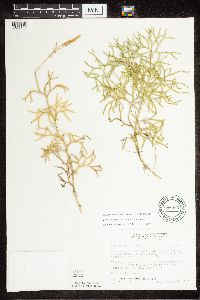 688005[1322840]Wheeler, Gerald 24581977-08-06 United States, Minnesota, Itasca, Scenic State Park. Itasca Co. Coll. Site #176 NE1/4 SE1/4 Sec.31 T61N R25W, approx. 35 mi N of Grand Rapids, Scenic State Park, near Bigfork; near the access road on the west side of the park.. 061N 25W 31, 47.728978 -93.579211 |
MIN:Plants | 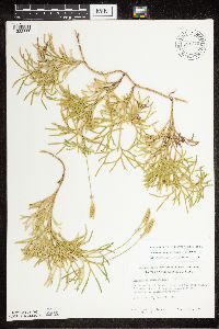 691370[1322837]Clemants, Steven 8501977-08-08 United States, Minnesota, Cook, Cook Co.; Intersection of Kekabic trail and Gunflint trail. 2.5 mi S of Seagull guard station; T65N, R4W, Sec.27, NE1/4;Superior National Forest;065N;04W;27, 48.084242 -90.825443 |
MIN:Plants | 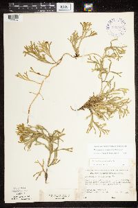 393259[1322830]Ownbey, Gerald 10451948-08-13 United States, Minnesota, Cook, Cook Co.; north promentory of Susie Island, Susie Islands near Grand Portage;North Shore / Susie Islands, The Nature Conservancy;064N;07E;, 47.726653 -90.386005 |
MIN:Plants |  463222[1322833]Lakela, Olga 145401952-07-07 United States, Minnesota, Koochiching, #11, west of the Observation Tower, Rainy Lake, Rilson Bay area;;071N;23W;, 48.606604 -93.401815 |
MIN:Plants |  353282[1322835]Moyle, J. 8891933-07-16 United States, Minnesota, Clearwater, Itasca Park; Clearwater Co, Sec. NW-NW-3 T.143 R.36;Itasca State Park;143N;36W;3, 47.231738 -95.223294 |
MIN:Plants |  354249[1322839]Grant, Martin 33011929-09-13 United States, Minnesota, Clearwater, Sec. SE-NE-14, T. 144, R. 38. Clearwater County;White Earth Indian Reservation / White Earth State Forest;144N;38W;14, 47.376543 -95.329718 |
MIN:Plants |  623070[1322836]Moore, John 274341971-10-16 United States, Minnesota, Anoka, Anoka Co.; west of roadway, N.E. 1/4 sect. 33, Bethel Twp. Cedar Creek Natural History Area.;Cedar Creek National History Area;034N;23W;33, 45.305423 -93.336637 |
MIN:Plants |  590214[1322831]Voss, E. 100631961-07-16 United States, Minnesota, Lake, Lake County...near south end of Cloquet Lake, sec. 9-16, T 57 N, R 9 W, ca. 14 mi. west of Findland;Superior National Forest;057N;09W;09, 47.437098 -91.48128 |
MIN:Plants |  541327[1327112]Raup, Hugh M. 45871932-09-04 Canada, Alberta, Sandy Lake, Athabaska |
MIN:Plants |  470278[1327162]Marie-Victorin 1940-08-07 Canada, Saint-Jerome, Terrebonne, water on a terrace of sand |
MIN:Plants |  358895[1327163]Reed, J.F. 4611934-07-22 United States, Maine, Oxford, W side of Swift River, Roxbury |
MIN:Plants | 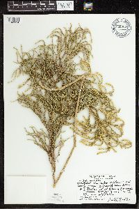 684906[1341834]Degener, Otto 34,403a1977-07-08 United States, Hawaii, Hawaii, 27 miles, Volcano;Hawaii Volcanoes National Park, 19.4 -155.3 |
MIN:Plants | 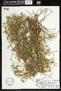 606844[1341835]Degener, Otto 3/,5051967-12-17 United States, Hawaii, Hawaii National Park. 27 miles, Puna, 19.4 -155.3 |
MIN:Plants | 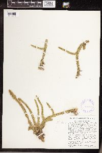 366647[1307793]Hodge, W.H. 47371940-09-09 Cuba, Santa Clara, Buenos Aires, Trinidad Mountains, 25 miles east of Soledad, Cienfuegos |
MIN:Plants | 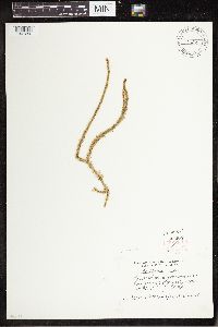 461690[1341252]Freda Stokes 1959-07-22 United States, South Carolina, Richland, University of South Carolina "Y" Camp, 33.999044 -81.026481 |
MIN:Plants |  423123[1322982]Ward, R.T. 8-9-49-131949-08-09 United States, Alaska, Juneau Ice Field; Taku B nunatak., 50.5 -58.75, 1280m |
MIN:Plants |  423121[1322983]Ward, R.T. 9-7-49-21949-09-07 United States, Alaska, Juneau Ice Field; Camp 4 ridge., 1311m |
MIN:Plants |  423124[1322984]Ward, R.T. 8-25-49-21949-08-25 United States, Alaska, Juneau Ice Field ... Taku B nunatak, 1311m |
MIN:Plants |  423122[1322985]Ward, R.T. 8-18-49-131949-08-18 United States, Alaska, Juncture Peak nunatak. Southwest-facing slope., 1219m |
Google Map
Google Maps is a web mapping service provided by Google that features a map that users can pan (by dragging the mouse) and zoom (by using the mouse wheel). Collection points are displayed as colored markers that when clicked on, displays the full information for that collection. When multiple species are queried (separated by semi-colons), different colored markers denote each individual species.