University of Minnesota
http://www.umn.edu/
612-625-5000
http://www.umn.edu/
612-625-5000
Minnesota Biodiversity Atlas
Bell Museum
Dataset: MIN-Plants
Taxa: Trifolium
Search Criteria: excluding cultivated/captive occurrences
Bell Museum plants | |
 MIN:Plants | 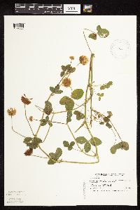 515219[1079087]Smith, Welby 193451991-07-09 United States, Minnesota, Koochiching, Koochiching Co.; at the SW corner of the intersection of TH 11 and CSAH 1, about 19 miles W of International Falls ...T70N R26W NE1/4 of SW1/4 of Sec 31. 070N 26W 31, 48.5119438 -93.7338867 |
MIN:Plants | 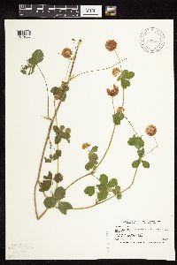 519787[1079088]Smith, Welby 189931991-06-25 United States, Minnesota, Todd, Buckhorn Wildlife Management Area. Todd Co.; Buckhorn State Wildlife Management Area, about 2 miles E of Grey Eagle; Todd Co.; Buckhorn State Wildlife Management Area, about 2 miles E of Grey Eagle; T127N R32W NW1/4 of SW1/4 of Sec 10. 127N 32W 10, 45.8250008 -94.6986084 |
MIN:Plants | 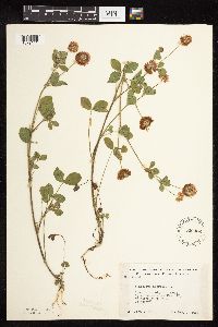 526432[1079141]Moore, John 212461951-08-07 United States, Minnesota, Grant, 4 1/2 mi N of Hwy 27, on N-S road to Wendell;;N;;, 46.100669 -96.101169 |
MIN:Plants | 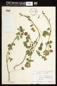 532778[1079184]Lakela, Olga 199421956-06-21 United States, Minnesota, Saint Louis, Reserve Mining Company RR tracks near Pine Lake, Headwaters of St. Louis River;;N;;, 47.451952 -91.812349 |
MIN:Plants | 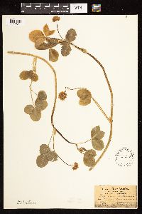 536245[1122821]Aiton, G. s.n.1890-07-00 United States, Minnesota, Hennepin, [no further data];;;;, 45 -93.47 |
MIN:Plants | 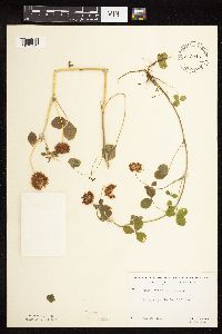 542916[1079112]Lakela, Olga; Davidson, Donald 215431957-07-24 United States, Minnesota, Cook, Lake Co. S35, T63, R5 [this actually in Cook Co.];Boundary Waters Canoe Area Wilderness / Superior National Forest;063N;05W;35, 47.9018236 -89.7757529 |
MIN:Plants | 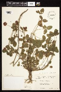 549879[1079142]Moore, John 222391954-09-21 United States, Minnesota, Pipestone, Pipestone Co.; 2 mi north east of Ihlen;;105N;46W;, 43.938661 -96.369759 |
MIN:Plants | 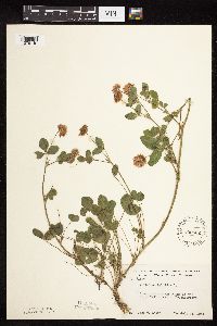 550032[1079140]Moore, John 219401954-07-22 United States, Minnesota, Wilkin, banks of the Otter Tail River at Breckenridge;;N;;, 46.272697 -96.583135 |
MIN:Plants | 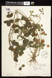 554351[1079145]Moore, John 229841956-09-12 United States, Minnesota, Clay, park area along the Red River at Moorhead;;N;;, 46.873104 -96.773191 |
MIN:Plants | 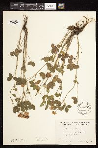 554440[1079137]Moore, John 232341957-06-17 United States, Minnesota, Martin, road embankment 1 1/2 mi SW of Truman;;N;;, 43.812369 -94.458486 |
MIN:Plants | 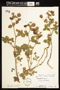 566335[1079135]Moore, John; Heig, V. 240001958-09-08 United States, Minnesota, Kittson, Hallock;;N;;, 48.774426 -96.943357 |
MIN:Plants | 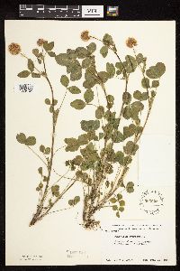 566625[1079134]Moore, John 239281958-06-14 United States, Minnesota, Kittson, along hwy 1 mi E of Hallock;;N;;, 48.774877 -96.912815 |
MIN:Plants | 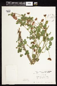 572432[1079187]Moore, John 255711961-07-06 United States, Minnesota, Anoka, Along the roadside near the laboratory grounds.;Cedar Creek Ecosystem Preserve;034N;23W;, 45.408613 -93.192178 |
MIN:Plants | 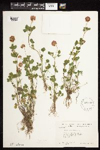 572624[1079166]Moore, John; Baker, Gary 254651961-06-21 United States, Minnesota, Houston, Houston County...near the upper end of Winnebago Valley 3 mi SE of Caledonia;Dorer Memorial Hardwood State Forest;102N;05W;00, 43.603957 -91.454353 |
MIN:Plants | 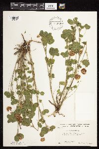 572636[1079167]Moore, John; Baker, Gary 254561961-06-20 United States, Minnesota, Faribault, along rr 1 mi SE of Wells;;N;;, 43.730986 -93.695604 |
MIN:Plants | 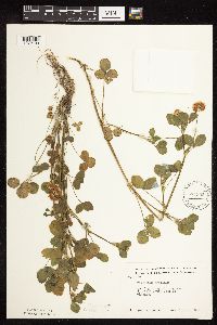 574395[1079109]Moore, John 245541959-06-03 United States, Minnesota, Blue Earth, along hwy 4 1/2 mi SE of Mankato;;N;;, 44.112298 -93.883657 |
MIN:Plants |  583505[1079181]Kellner, H. 1141956-06-28 United States, Minnesota, Lake, Lake Co, Station 4b, Lafayette Bluff [this is near mouth of Encampment River];North Shore;053N;10W;11, 47.09139 -91.57111 |
MIN:Plants |  592375[1079101]Westkaemper, Remberta s.n.1963-06-00 United States, Minnesota, Stearns, Stearns Co. St. Joseph, St. Benedict College campus;;124N;29W;, 45.580034 -94.393284 |
MIN:Plants |  594362[1079185]Thorne, Robert 307501962-06-30 United States, Minnesota, Clearwater, along path, N end of Bear Paw Point, between N and E arms. lake Itasca, Lake Itasca State park, NE1/4 S11, T143N, R36W;Itasca State Park;143N;36W;11, 47.2175215 -95.2014955 |
MIN:Plants |  594410[1079179]Thorne, Robert 310761962-07-16 United States, Minnesota, Clearwater, campus, S side, Itasca State Park, NE1/4 S11, T143N, R36W;Itasca State Park;143N;36W;11, 47.2175215 -95.2014955 |
MIN:Plants |  604011[1079170]Moore, John; Hsi, Yu-tseng [Eugene] 271651967-06-15 United States, Minnesota, Winona, along the W side of Lake Winona;;107N;07W;, 44.034763 -91.64168 |
MIN:Plants |  616457[1079162]Moore, John; Moore, Marjorie 1401969-06-17 United States, Minnesota, Crow Wing, Crow Wing Natural History Area, S end of Chandler Lake, SW1/4 S22, Garrison Twp;Crow Wing Natural Area;044N;28W;22, 46.2789902 -93.8633363 |
MIN:Plants |  670592[1079189]Heitlinger, M. 2561971-07-11 United States, Minnesota, McLeod, Schaefer Prairie, SE1/4 S34, T115N, R29W; E of prominent N-S ridge and ca 10 m N of old field;Schaefer Prairie, The Nature Conservancy;115N;29W;34, 44.7250496 -94.3049103 |
MIN:Plants |  673650[1079110]Borchard, Alma s.n.1937-07-04 United States, Minnesota, Saint Louis, Duluth;;N;;, 46.783273 -92.106579 |
MIN:Plants | 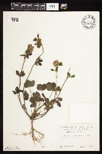 691268[1079183]Lightfoot, J. s.n.1977-09-01 United States, Minnesota, Pine, Pine Co. SW1/4 of the NW1/4 S20, T43, R21;;043N;21W;20, 46.1947638 -93.0223974 |
MIN:Plants | 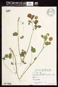 698285[1079136]Wheeler, Gerald; Glaser, Paul 30851978-06-30 United States, Minnesota, Beltrami, Ca 14.5 mi N of the Waskish Airport on Rte 72, just W of the road, next to hwy;Red Lake Peatland Scientific Natural Area;156N;31W;1, 47.9256196 -94.5581684 |
MIN:Plants | 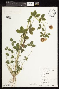 698671[1079125]Sather, Nancy 5051977-08-16 United States, Minnesota, Saint Louis, St. Louis Co. Burley's Resort on White Iron Lake, SW1/4 NE1/4 S12, T62N, R12W;Superior National Forest;062N;12W;12, 47.8689795 -91.809651 |
MIN:Plants | 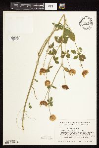 712062[1079124]Smith, Welby 10831979-07-15 United States, Minnesota, Wright, T121N [120?] R26W; SE1/4 SW1/4 S13; between Soo Line tracks and State Hwy 55, 1.8 mi NW of its jnc with State Hwy 25 in T121N [120?] R26W; SE1/4 SW1/4 S13; between Soo Line tracks and State Hwy 55, 1.8 mi NW of its jnc with State Hwy 25 in Buffalo. 121N 26W 13, 45.2896731 -93.9010148 |
MIN:Plants | 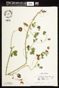 717088[1079117]Heitlinger, M. 7961975-07-23 United States, Minnesota, Anoka, Anoka Co. Allison Savanna, N1/2 of NE1/4 of S2, T33N, R23W, N central portion of old field on W side of tract;Helen Allison Savanna Scientific Natural Area;033N;32W;2, 45.3777015 -93.1738785 |
MIN:Plants | 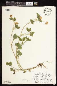 717478[1079119]Mathisen, Ron 1121979-07-07 United States, Minnesota, Hubbard, Spearhead Lake Reserve;Spearhead Lake Preserve (Audubon);145N;34W;, 47.372044 -94.95883 |
MIN:Plants | 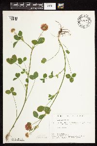 722667[1079123]Lustig, K. 6291979-07-05 United States, Minnesota, Anoka, 18 mi SE of Cambridge;Boot Lake Scientific Natural Area;033N;22W;, 45.34066 -93.08146 |
MIN:Plants | 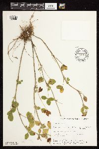 734393[1079098]Cross-Cella, J. 2801980-08-27 United States, Minnesota, Becker, Green Water Lake Natural Area: 5 mi W of Ponsford, SE1/4 NE1/4 S33, T141N, R38W;Greenwater Lake Scientific Natural Area / White Earth Indian Reservation;141N;38W;33, 46.9838935 -95.4976994 |
MIN:Plants | 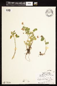 739519[1079114]Stackler, S. 15611976-06-17 United States, Minnesota, Carlton, Skunk Creek Basin, away from rr tracks, SW along Soo Line from Duesler crossing, ca 7 1/2 mi E Barnum (T45N, R17W, S5);;045N;17W;5, 46.4105264 -92.5192101 |
MIN:Plants | 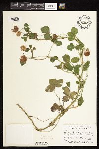 746558[1079190]Smith, Welby 44831981-06-24 United States, Minnesota, Mower, Wild Indigo Scientific Natural Area. Wild Indigo Scientific and Natural Area, ca 2 1/4 mi E of the jnc of State Hwy 56 and Co Hwy 2 in Brownsdale, SE1/4 SW1/ Wild Indigo Scientific and Natural Area, ca 2 1/4 mi E of the jnc of State Hwy 56 and Co Hwy 2 in Brownsdale, SE1/4 SW1/4 S12, T103N, R17W. 103N 17W 12, 43.7395999 -92.8192378 |
MIN:Plants | 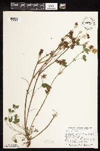 758941[1079161]Smith, Welby 74441982-08-20 United States, Minnesota, Mower, Racine Prairie Scientific Natural Area. Racine Prairie State Scientific and Natural Area, adjacent to E side of US Trunk Hwy 63, ca 2 mi N of Racine, NE1/4 NE1/ Racine Prairie State Scientific and Natural Area, adjacent to E side of US Trunk Hwy 63, ca 2 mi N of Racine, NE1/4 NE1/4 S22, T104N, R14W. 104N 14W 22, 43.7976425 -92.4992666 |
MIN:Plants | 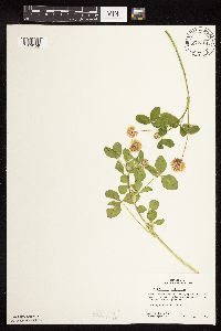 772314[1079159]Boe, J. 4651979-06-29 United States, Minnesota, Lake of the Woods, Roseau Flowage, SW of dam, T159N, R36W, SW1/4 S32;;159N;36W;32, 48.5472477 -95.3101278 |
MIN:Plants |  772635[1079160]Boe, J. 5731979-07-06 United States, Minnesota, Lake of the Woods, on N bank of Rapid River where crossed by hwy 72, T158N, R30W, NW1/4 S6;;158N;30W;6, 48.5337891 -94.5498309 |
MIN:Plants |  774286[1079158]Monson, Paul 54101983-06-18 United States, Minnesota, Saint Louis, Voyageurs National Park, International Falls, R20W, T69N, SE1/4 S16, Lake Kabetogama, N shore;Voyageurs National Park;069N;20W;16, 48.4629469 -92.9069348 |
MIN:Plants |  778303[1079154]Duxbury, Alexis 18301983-07-23 United States, Minnesota, Murray, Lundblad Prairie: W1/2 NW1/4 S1, T105N, R41W;Lundblad Prairie Scientific Natural Area;105N;41W;1, 43.9278165 -95.7133858 |
MIN:Plants |  778373[1079157]Duxbury, Alexis 14931983-07-10 United States, Minnesota, Redwood, Redwood Co. Wahpeton Prairie: S1/2 NW1/4 S29, T110N, R38W;Wahpeton Prairie, The Nature Conservancy;110N;38W;29, 44.3047823 -95.4408133 |
MIN:Plants |  778374[1079155]Duxbury, Alexis 14081983-06-30 United States, Minnesota, Lincoln, Hole-in-the-Mountain Prairie: portions of S1/2 S19, and SW1/4 S20, T109N, R45W;Hole-in-the-Mountain Prairie, The Nature Conservancy;109N;45W;, 44.2337348 -96.291139 |
MIN:Plants |  778375[1079156]Duxbury, Alexis 16951983-07-19 United States, Minnesota, Jackson, Blue Gentian Prairie: part of SW1/4 SE1/4 S13, T103N, R36W;Blue Gentian Prairie;103N;36W;13, 43.7249294 -95.1050766 |
MIN:Plants |  795776[1079153]Sanford, J. s.n.1947-08-02 United States, Minnesota, Clearwater, Itasca State Park, Biological Station;Itasca State Park;143N;36W;, 47.226096 -95.194411 |
MIN:Plants |  829283[1079090]Myhre, K. 21711992-06-08 United States, Minnesota, Cass, Cass Co. Located 1/2 mi S of the town of Pine River; T137N R29W NW1/4 of SW1/4 of Sec 6;;137N;29W;6, 46.7113578 -94.3984754 |
MIN:Plants | 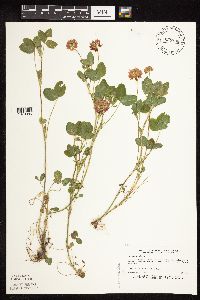 829296[1079086]Myhre, K. 22761992-06-18 United States, Minnesota, Cass, Cass Co. Located 1 mi E of Wabedo Lake; T140N R28W NW1/4 of SW1/4 of Sec 25;;140N;28W;25, 46.9127922 -94.1639891 |
MIN:Plants | 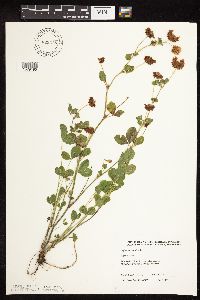 829578[1079195]Boe, J. 920801071992-08-01 United States, Minnesota, Marshall, Marshall Co. Agassiz NWR; NE1/4 NE1/4 Sec.36 T156N R41W.;Agassiz National Wildlife Refuge;156N;41W;36, 48.2878486 -95.8627917 |
MIN:Plants | 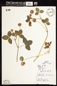 833527[1079092]Juhnke, C. 0951991-06-07 United States, Minnesota, Fillmore, Forestville State Park. Fillmore Co. T102N R12W Sec.20 NE NE SE; along trail to Mystery Cave II;Forestville State Park;102N;12W;20, 43.6236562 -92.2986037 |
MIN:Plants | 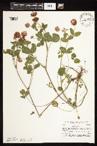 836343[1079192]Smith, Welby 188411991-06-14 United States, Minnesota, Morrison, Camp Ripley Military Reservation. Camp Ripley Military Reservation Morrsion Co. Along East Boundary Road, about 2.5 km N of the airfield. UTM: 394700E 510 Camp Ripley Military Reservation Morrsion Co. Along East Boundary Road, about 2.5 km N of the airfield. UTM: 394700E 5107700N T131N R30W SE1/4 of NW1/4 of Sec 32. 131N 30W 32, 46.1145839 -94.4846274 |
MIN:Plants | 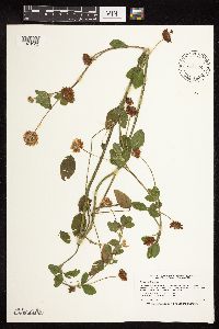 840604[1079122]Smith, Welby 181821990-08-29 United States, Minnesota, Dodge, Pheasants Forever Wildlife Management Area. Dodge Co. 'Pheasants Forever' State Wildlife Management Area, about 2.5 mi W-SW of Mantorville; Dodge Co. 'Pheasants Forever' State Wildlife Management Area, about 2.5 mi W-SW of Mantorville; T107N R17W SW1/4 of SE1/4 of Sec 24. 107N 17W 24, 44.0530548 -92.9300003 |
MIN:Plants | 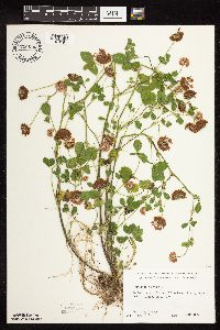 700636[1079191]Ownbey, Gerald 60221978-07-07 United States, Minnesota, Clearwater, Clearwater Co.; De Soto Lake. E side of N end near trail; Itasca State Park;Itasca State Park;143N;36W;, 47.152357 -95.214797 |
MIN:Plants | 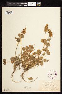 264583[1079197]Holzinger, John s.n.1897-07-00 United States, Minnesota, Winona, near Minnesota City, Winona Co.;;107N;08W;, 44.093852 -91.749596 |
MIN:Plants | 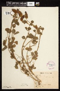 267025[1079196]Stevenson, J. 3261912-08-19 United States, Minnesota, Itasca, Grand Rapids;;055N;25W;, 47.225976 -93.523348 |
MIN:Plants | 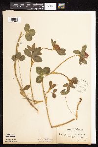 143677[1079295]Anonymous s.n.1892-06-00 United States, Minnesota, Meeker, Litchfield;;N;;, 45.127185 -94.528047 |
MIN:Plants | 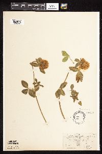 143678[1079288]Manning, Warren 5371883-07-02 United States, Minnesota, Wabasha, Lake City;;111N;12W;, 44.449412 -92.266844 |
MIN:Plants | 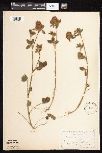 143679[1079286]Moyer, Lycurgus s.n.1893-07-08 United States, Minnesota, Chippewa, Montevideo;;117N;40W;, 44.953148 -95.715397 |
MIN:Plants | 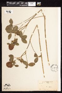 143680[1079285]Moyer, Lycurgus s.n.1897-07-25 United States, Minnesota, Chippewa, Montevideo;;117N;40W;, 44.953148 -95.715397 |
MIN:Plants |  143681[1079258]Manning, Sara s.n.1883-07-02 United States, Minnesota, Wabasha, Lake City;;111N;12W;, 44.449412 -92.266844 |
MIN:Plants |  143682[1079279]Ainslie, G. 20751902-06-19 United States, Minnesota, Olmsted, Rochester;;106N;14W;, 43.97834 -92.49834 |
MIN:Plants |  143683[1079346]Taylor, B. s.n.1891-06-00 United States, Minnesota, Waseca, Janesville;;N;;, 44.116078 -93.708004 |
MIN:Plants |  143684[1079256]Sheldon, Edmund S441891-06-00 United States, Minnesota, Le Sueur, Elysian;;109N;24W;, 44.202392 -93.675383 |
MIN:Plants | 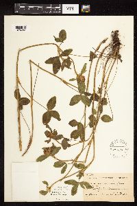 143685[1079255]Frost, W. F1261892-06-00 United States, Minnesota, Meeker, Litchfield;;N;;, 45.127185 -94.528047 |
MIN:Plants | 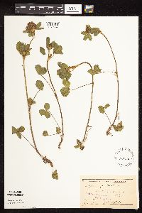 143686[1079357]Sheldon, Edmund S24481892-06-00 United States, Minnesota, Mille Lacs, Mille Lacs Lake;;N;;, 46.167478 -93.631145 |
MIN:Plants | 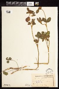 143687[1079253]Frost, W. F130 (a)1892-06-00 United States, Minnesota, Meeker, Acton [pioneer village], Meeker Co.;;119N;32W;26, 45.0877751 -94.6653797 |
MIN:Plants |  143688[1079289]Campbell, Jennie C1401896-07-00 United States, Minnesota, Stearns, St. Cloud;;N;;, 45.5582 -94.181183 |
MIN:Plants | 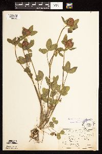 143690[1122825]Sandberg, John s.n.1890-06-00 United States, Minnesota, Hennepin, Roadsides;;N;;, 45.006226 -93.451965 |
MIN:Plants | 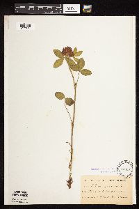 143691[1079361]Kassube, J. s.n.1878-06-00 United States, Minnesota, Hennepin, Minneapolis;;N;;, 44.970736 -93.268643 |
MIN:Plants | 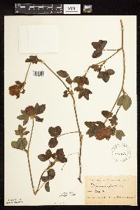 143692[1079254]Oestlund, O. s.n.1986-06-00 United States, Minnesota, Hennepin, Minneapolis;;N;;, 44.970736 -93.268643 |
MIN:Plants | 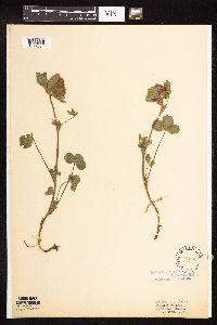 143693[1079354]White, Sidney s.n.1889-05-20 United States, Minnesota, Winona, Winona;;N;;, 43.978945 -91.713211 |
MIN:Plants | 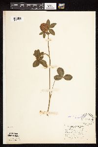 143694[1079360]Hammond, George 131881-06-00 United States, Minnesota, Wabasha, Lake City;;111N;12W;, 44.449412 -92.266844 |
MIN:Plants | 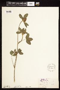 143695[1079250]Herrick, C. s.n.1877-06-01 United States, Minnesota, Hennepin, Minneapolis;;N;;, 44.970736 -93.268643 |
MIN:Plants | 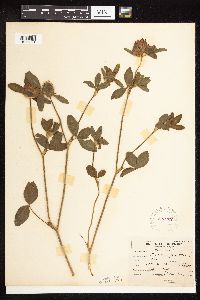 226227[1079324]Roberts, Thomas s.n.1904-07-00 United States, Minnesota, Wabasha, Brook Lodge;;N;;, 44.277558 -92.210339 |
MIN:Plants | 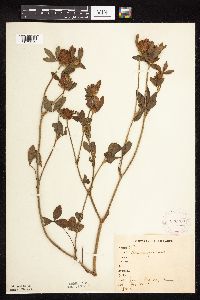 226263[1079312]Stevenson, J. 3931912-08-30 United States, Minnesota, Itasca, Grand Rapids;;055N;25W;, 47.225976 -93.523348 |
MIN:Plants | 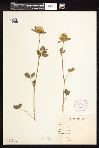 265426[1079328]Goldsmith, G. G871912-00-00 United States, Minnesota, Rice, Northfield;;N;;, 44.4496671 -93.1708471 |
MIN:Plants |  267057[1079313]Stevenson, J. 2651912-08-01 United States, Minnesota, Beltrami, Bemidji;;146N;33W;09, 47.4755499 -94.874419 |
MIN:Plants |  276060[1079348]Moyle, J. 801930-06-28 United States, Minnesota, Clearwater, Itasca Park, along road, N of campus; NE1/4 SE1/4 Sec. 2 T143N R36W;Itasca State Park;143N;36W;2, 47.1452906 -95.2013601 |
MIN:Plants |  278162[1079329]Roberts, Thomas s.n.1887-06-28 United States, Minnesota, Hennepin, Minneapolis;;N;;, 44.970736 -93.268643 |
MIN:Plants |  282428[1079311]Buell, Murray 2901932-06-27 United States, Minnesota, Clearwater, Itasca Park. Along road near campus. SE1/4 SE1/4 T143N, R36W.;Itasca State Park;143N;36W;2, 47.1452906 -95.2013601 |
MIN:Plants | 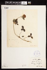 334716[1079303]Anonymous [poss. R.C. Perry] s.n.1884-09-00 United States, Minnesota, Washington, Dellwood, Washington Co.;;030N;21W;, 45.097964 -92.967631 |
MIN:Plants | 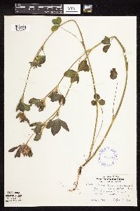 345826[1079282]Lakela, Olga 20271937-07-03 United States, Minnesota, Saint Louis, Bay shore near Duluth Harbor;;N;;, 46.777851 -92.101 |
MIN:Plants |  348151[1079340]Seim, A. 501937-06-19 United States, Minnesota, Ramsey, Near Y.M.C.A, Midway district, St. Paul.;;028N;23W;, 44.962346 -93.166878 |
MIN:Plants | 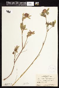 348224[1079325]McCartney, James 691938-07-14 United States, Minnesota, Scott, Hwy. 5 and Grass [sic =Geis] Lake. Scott Co.;;114N;23W;00, 44.688577 -93.546512 |
MIN:Plants | 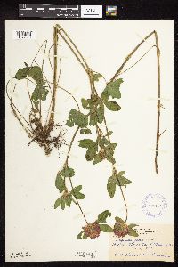 349634[1079310]Hedman, H. 231938-06-00 United States, Minnesota, Hennepin, W shore of Gideon Bay, Lake Minnetonka.;;N;;, 44.909285 -93.591156 |
MIN:Plants |  351328[1079278]Benner, F.; Benner, J. 4921929-07-27 United States, Minnesota, Cook, 1/2 mi east Grand Portage;Grand Portage Indian Reservation / North Shore;063N;06E;, 47.966763 -89.674004 |
MIN:Plants |  366929[1079352]Moore, John; Moore, Marjorie 102101938-06-26 United States, Minnesota, Dakota, 1/4 mi W of Fifth Avenue and just S of Church Street, South St. Paul;;028N;22W;, 44.873603 -93.035331 |
MIN:Plants |  381075[1079364]Moore, John 156401942-06-20 United States, Minnesota, Stearns, Sauk River, Sauk Center, Stearns Co.;;126N;34W;, 45.737596 -94.941623 |
MIN:Plants |  383065[1079290]Moore, John; Hall, Robert 161171943-09-08 United States, Minnesota, Lake, 1 mi W of Finland on the Ely-Finland Road;;N;;, 47.414634 -91.27044 |
MIN:Plants | 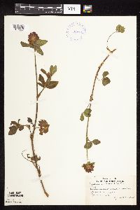 392961[1079294]Lakela, Olga; et al. 64541946-06-26 United States, Minnesota, Saint Louis, Sandbar Island in Duluth harbor, Duluth;;N;;, 46.771987 -92.096966 |
MIN:Plants | 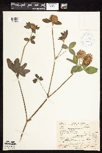 395235[1079293]Loula, E. 71938-07-10 United States, Minnesota, Cook, Brule River; T64N R1E Sec. 32;Superior National Forest;064N;01E;32, 47.9831438 -90.3503334 |
MIN:Plants | 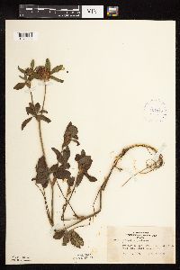 407113[1079338]Lakela, Olga 97371949-09-02 United States, Minnesota, Saint Louis, Terrace of Ash River, the end of the road.;;N;;, 48.39867 -92.810673 |
MIN:Plants | 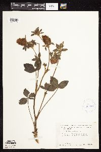 412401[1079296]Moore, John; Moore, Marjorie 120881939-08-23 United States, Minnesota, Koochiching, Koochiching Co.; 4 mi east of Birchdale;;;;, 48.626872 -94.014268 |
MIN:Plants |  413012[1079246]Moore, John; Moore, Marjorie 118491939-08-17 United States, Minnesota, Koochiching, Koochiching Co.; Along the roadside west of Tilson Bay, Rainy Lake.;;071N;23W;, 48.599405 -93.231439 |
MIN:Plants |  418927[1079335]Ahlgren, Clifford 3981949-08-31 United States, Minnesota, Lake, Quetico-Superior Wilderness Research Center...Lake Co.;Boundary Waters Canoe Area Wilderness / Superior National Forest;064N;10W;09, 48.0316509 -91.6188616 |
MIN:Plants |  419315[1079337]Briggs, John De Q.; Moore, Marjorie 781945-08-06 United States, Minnesota, Cook, Near Sawbill Lodge. T62N, R4W.;Boundary Waters Canoe Area Wilderness / Superior National Forest;063N;04W;, 47.865178 -90.884444 |
MIN:Plants |  420869[1079341]Lakela, Olga 117141950-08-25 United States, Minnesota, Saint Louis, The resort grounds at Curtain Falls on Crooked Lake;Boundary Waters Canoe Area Wilderness / Superior National Forest;066N;12W;, 48.237307 -91.906929 |
MIN:Plants |  422702[1079309]Lakela, Olga 79081948-09-18 United States, Minnesota, Saint Louis, Roadside terrace near Floodwood;;N;;, 46.927469 -92.916558 |
MIN:Plants |  422708[1079339]Lakela, Olga 75011948-06-15 United States, Minnesota, Carlton, Esko;;N;;, 46.705776 -92.363247 |
MIN:Plants |  424138[1079291]Emanuel, J. 981946-07-28 United States, Minnesota, Itasca, County: Itasca. Locality: Nashwauk Township (3 mi No. Keewatin);;057N;22W;00, 47.443048 -93.073864 |
MIN:Plants |  429361[1079318]Smith, Welby 196821991-07-18 United States, Minnesota, Roseau, Roseau Co.; In Warroad, boat landing on Lake of the Woods (Muskeg Bay); T 163N R 36W SE1/4 of SW1/4 of Sec 28;;163N;36W;28, 48.9055557 -95.3016663 |
MIN:Plants | 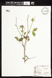 434981[1079261]Swanson, Gary 271999-07-15 United States, Minnesota, Morrison, Crane Meadows National Wildlife Refuge; SWSE 30-40-31;Crane Meadows National Wildlife Refuge;040N;31W;30, 45.9338958 -94.2515644 |
MIN:Plants | 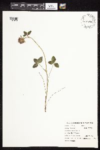 435063[1079260]Hanson, Catherine 2351999-07-16 United States, Minnesota, Morrison, Crane Meadows National Wildlife Refuge; NWSE 30-40-31;Crane Meadows National Wildlife Refuge;040N;31W;30, 45.9338958 -94.2515644 |
Google Map
Google Maps is a web mapping service provided by Google that features a map that users can pan (by dragging the mouse) and zoom (by using the mouse wheel). Collection points are displayed as colored markers that when clicked on, displays the full information for that collection. When multiple species are queried (separated by semi-colons), different colored markers denote each individual species.