University of Minnesota
http://www.umn.edu/
612-625-5000
http://www.umn.edu/
612-625-5000
Minnesota Biodiversity Atlas
Bell Museum
Dataset: MIN-Plants
Taxa: Lycopodiaceae
Search Criteria: excluding cultivated/captive occurrences
Bell Museum plants | |
 MIN:Plants |  Lycopodium lagopus (Laestadius ex C. Hartman) G. Zinserling ex Kuzeneva-Prochorova 86864[1341579]Holway 1905-08-27 Canada, Alberta, Morraine Lake, Laggan, 45.38951 -74.70515, 1829m |
MIN:Plants |  Lycopodium lagopus (Laestadius ex C. Hartman) G. Zinserling ex Kuzeneva-Prochorova 55205[1341580]Butters 1904-08-26 Canada, Alberta, Mount Temple, 51.350556 -116.206667, 1829m |
MIN:Plants |  Lycopodium lagopus (Laestadius ex C. Hartman) G. Zinserling ex Kuzeneva-Prochorova 86862[1341581]Shaw, Charles H. 1905-08-03 Canada, Selkirk, near Goldstream, 48.45 -123.533333, 914m |
MIN:Plants |  Lycopodium lagopus (Laestadius ex C. Hartman) G. Zinserling ex Kuzeneva-Prochorova 579483[1341582]H.M. & L.G. Raup 1944-08-12 United States, Alaska, North slope of Nutzotin Mts., 69 -152 |
MIN:Plants | 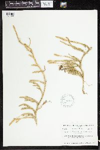 Lycopodium lagopus (Laestadius ex C. Hartman) G. Zinserling ex Kuzeneva-Prochorova 580016[1341583]Raup, H.M. 1939-08-02 Canada, Mackenzie, NE of Brintnell Lake Camp, Mackenzie Mts., 55.8 -114.716667, 1128m |
MIN:Plants | 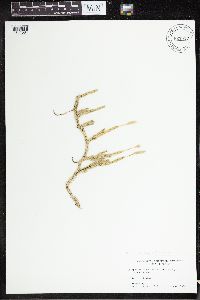 Lycopodium lagopus (Laestadius ex C. Hartman) G. Zinserling ex Kuzeneva-Prochorova 827517[1341584]Grether, David F. 1980-08-01 United States, Alaska, McKinley Village, 63.655 -148.829722 |
MIN:Plants | 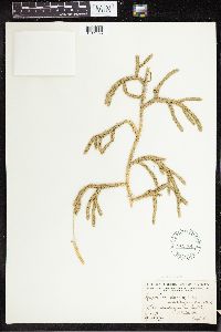 Lycopodium lagopus (Laestadius ex C. Hartman) G. Zinserling ex Kuzeneva-Prochorova 541324[1341585]Raup, H.M. 1932-09-04 Canada, Alberta, Lake Athabaska, 59 -110.5 |
MIN:Plants | 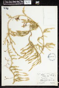 Lycopodium lagopus (Laestadius ex C. Hartman) G. Zinserling ex Kuzeneva-Prochorova 497185[1341586]Harper, Francis 1953-08-09 Canada, Quebec, Mollie T. Lake |
MIN:Plants | 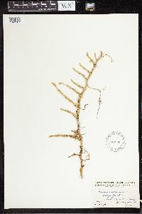 Lycopodium lagopus (Laestadius ex C. Hartman) G. Zinserling ex Kuzeneva-Prochorova 541250[1341587]Raup, H.M. 1932-07-26 Canada, Alberta, Mt. Selwyn, 55.991667 -123.606667, 1067m |
MIN:Plants | 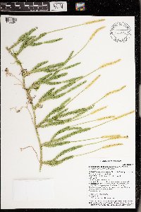 Lycopodium lagopus (Laestadius ex C. Hartman) G. Zinserling ex Kuzeneva-Prochorova 976673[1402264]Timothy J. S. Whitfeld 30012021-07-20 United States, Minnesota, St. Louis, Between Crane Lake and Dovre Lake, 48.278126 -92.44742, 395m |
MIN:Plants | 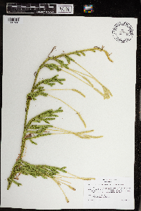 Lycopodium lagopus (Laestadius ex C. Hartman) G. Zinserling ex Kuzeneva-Prochorova 968933[1391568]Milburn, Scott 242020-08-30 United States, Minnesota, Lake, Located 2.45km due east of Birch Lake., 47.773089 -91.72262 |
MIN:Plants | 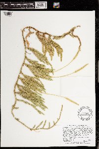 Lycopodium lagopus (Laestadius ex C. Hartman) G. Zinserling ex Kuzeneva-Prochorova 973384[1398937]Lee, Michael MDL60192012-07-20 United States, Minnesota, Lake, Boundary Waters Canoe Area Wilderness; Rolling bedrock terrain on the northeast side of Wind Lake, 17 miles northeast of Ely., 48.0175981087 -91.5066901567, 411m |
MIN:Plants | 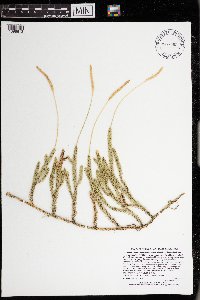 Lycopodium lagopus (Laestadius ex C. Hartman) G. Zinserling ex Kuzeneva-Prochorova 973060[1398613]Lee, Michael MDL61712012-08-30 United States, Minnesota, Morrison, Crane Meadows State Wildlife Management Area within Crane Meadows National Wildlife Refuge; Along the lower reaches of Buckman Creek on gently rolling sandy outwash five miles west of Buckman, eight miles southeast of Little Falls., 45.9094711076 -94.2023467384, 337m |
MIN:Plants | 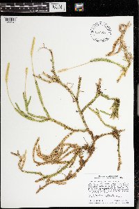 Lycopodium lagopus (Laestadius ex C. Hartman) G. Zinserling ex Kuzeneva-Prochorova 974620[1396949]Smith, Welby R WRS365742019-09-24 United States, Minnesota, Carlton, University of Minnesota Cloquet Forestry Experiment Station, about 7 km (4.3 miles) west of the approximate center of Cloquet., 46.707169 -92.53564 |
MIN:Plants | 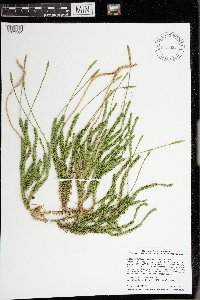 Lycopodium lagopus (Laestadius ex C. Hartman) G. Zinserling ex Kuzeneva-Prochorova 976031[1373584]Smith, Welby R WRS366972020-06-17 United States, Minnesota, Lake Of The Woods, Beltrami Island State Forest. Along Bankton Forest Road (south side) about 57 km (35.4 miles) southeast of Warroad at a heading of 149 degrees., 48.47116 -94.9221 |
MIN:Plants | 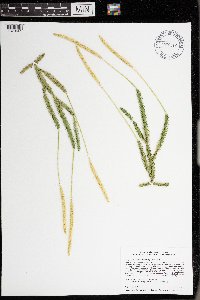 Lycopodium lagopus (Laestadius ex C. Hartman) G. Zinserling ex Kuzeneva-Prochorova 976112[1373665]Smith, Welby R WRS368062020-08-12 United States, Minnesota, St. Louis, About 3.3 km (2 miles) west of the edge of Hibbing. In an abandoned iron ore mine site. Habitat left to natural recovery for perhaps 50+ years., 47.41787 -92.99126 |
MIN:Plants |  Lycopodium lagopus (Laestadius ex C. Hartman) G. Zinserling ex Kuzeneva-Prochorova 977603[1401191]Anderson, Derek S. 34602020-11-06 United States, Minnesota, Pine, Nemadji State Forest. About 14.5 km northwest of Cloverton. On the Park Truck Trail, about 11 km west of the intersection with the Gandy Dancer Trail., 46.28344 -92.40369 |
MIN:Plants |  Lycopodium lagopus (Laestadius ex C. Hartman) G. Zinserling ex Kuzeneva-Prochorova 977619[1401207]Anderson, Derek S. 34422020-10-15 United States, Minnesota, Chisago, Carlos Avery WMA. About 3 km north-northeast of Wyoming. About 440 meters southeast of the intersection of Foxhill Ave. and 287th St., 45.36291 -92.98355 |
MIN:Plants |  Lycopodium lagopus (Laestadius ex C. Hartman) G. Zinserling ex Kuzeneva-Prochorova 976975[1402555]Lee, Michael MDL63172013-07-26 United States, Minnesota, Lake, Boundary Waters Canoe Area Wilderness. Fairly rugged bedrock terrain north of Jackfish Bay, Basswood Lake, 12 miles north-northeast of Ely., 48.05808357 -91.7399327, 399m |
MIN:Plants |  Lycopodium lagopus (Laestadius ex C. Hartman) G. Zinserling ex Kuzeneva-Prochorova 977318[1402902]Lee, Michael MDL66902014-08-23 United States, Minnesota, St. Louis, Boundary Waters Canoe Area Wilderness. Strongly rolling bedrock terrain north of Fourtown Lake, 15 miles north of Ely, just inland from the south shore of Bullet Lake., 48.12750372193 -91.80537707677, 107m |
MIN:Plants | 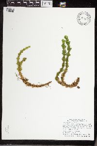 Huperzia lucidula (Michaux) Trevisan 914863[1338793]Smith, Welby 314652009-09-11 United States, Minnesota, Cook, Boundary Waters Canoe Area Wilderness / Superior National Forest. Cook County ... Boundary Waters Canoe Area Wilderness, Superior National Forest. At the south end of the Royal River ... T64N R3E NE1/4 of NW1/4 of Sec 11. 064N 03E 11, 48.0483333 -90.0272222 |
MIN:Plants | 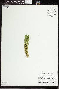 Huperzia lucidula (Michaux) Trevisan 431696[1338857]Dahle, R.M. 020432002-10-09 United States, Minnesota, Itasca, Itasca County...About two miles northeast of the town of Swan River. On the east side of Hwy 65, about half way between the highway and a small bog lake...T 53 R 22 NW1/4 of NE!/4 of Sec 6. 053N 22W 6, 47.1069444 -93.1711111 |
MIN:Plants | 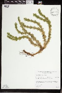 Huperzia lucidula (Michaux) Trevisan 475966[1338861]Gerdes, Lynden 25741998-06-02 United States, Minnesota, Cook, T64N R01E S28SWSWNE. Cook County; Superior National Forest, BWCAW. Clearwater Lake (Cliff 2b).;Boundary Waters Canoe Area Wilderness / Superior National Forest;064N;01E;28, 48.08486 -90.335202 |
MIN:Plants | 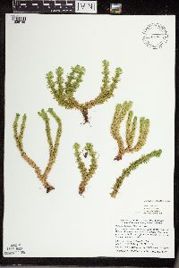 Huperzia lucidula (Michaux) Trevisan 456104[1338785]Dahle, Rolf M. 200222000-08-16 United States, Minnesota, Itasca, In a taconite tailings basin just south of the village of Holman; T 56 R 24 SE1/4 of SW1/4 of Sec 26, 47.2994461 -93.3533325 |
MIN:Plants |  Huperzia lucidula (Michaux) Trevisan 914149[1338784]Lee, Michael MDL41912006-04-26 United States, Minnesota, Todd, Todd County ... South of Molly Lake, two miles southeast of Burtrum ... T127N R32W NW1/4 of NE1/4 of NW1/4 Sec.1, NW1/4 of SE1/4 of NE1/4 Sec.1. 127N 32W 1, 45.838472 -94.654077 |
MIN:Plants |  Huperzia lucidula (Michaux) Trevisan 498957[1338856]Lee, Michael MDL31162001-09-18 United States, Minnesota, Lake, Superior National Forest. Lake County ... Superior National Forest. On the southeast side of Thunderbird Lake 4 1.2 miles north of Cramer ... T59N R6W SE1/4 of NW1/4 of SE1/4 Sec. 16. 059N 06W 16, 47.594518 -91.09675 |
MIN:Plants |  Huperzia lucidula (Michaux) Trevisan 907258[1338834]Smith, Welby 312422008-08-21 United States, Minnesota, Beltrami, Red Lake Wildlife Management Area. Beltrami County...At the west end of the road that skirts the north shore of Upper Red Lake, about 12 miles west of Highway 72 in Waskish...T 155N R 32W SE1/4 of SW1/4 of Sec 31. 155N 32W 31, 48.1969444 -94.8097222 |
MIN:Plants |  Huperzia lucidula (Michaux) Trevisan 492056[1338759]Whitfeld, T.J.S. 5772005-05-18 United States, Minnesota, Clearwater, White Earth Indian Reservation. Clearwater County...6 miles south of Roy Lake; 1 mile south of Norris Road; 3/4 mile east of Strawberry Mountain Road...T144N R38W SESE31. 144N 38W 31, 47.245525 -95.540928 |
MIN:Plants |  Huperzia lucidula (Michaux) Trevisan 907259[1338753]Smith, Welby 309202008-06-17 United States, Minnesota, Cook, Cook County...About 2.5 miles south of Eagle Mountain, in Superior National Forest...T 62N R 2W SW1/4 of SW1/4 of Sec 11;Superior National Forest;062N;02W;11, 47.867577 -90.542617 |
MIN:Plants |  Huperzia lucidula (Michaux) Trevisan 55272[1338923]Rust, Missus s.n.1890-09-00 United States, Pennsylvania, Bucks, Buckwampum Mt. Bucks Co. |
MIN:Plants |  Huperzia lucidula (Michaux) Trevisan 643947[1338922]Ahles, H. 763371973-03-24 United States, New York, Dutchess, Dutchess County ... north of Cardinal Road and west of Forest Drive, Hyde Park;Roosevelt-Vanderbilt National Historic Site |
MIN:Plants |  Huperzia lucidula (Michaux) Trevisan 220279[1338835]Rosendahl, C. 49251936-05-16 United States, Minnesota, Wabasha, 2 mi E of Lake City, Wabasha Co.;;N;;, 44.449405 -92.226268 |
MIN:Plants | 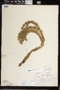 Huperzia lucidula (Michaux) Trevisan 229273[1338733]Rosendahl, C.O. 45331924-07-01 United States, Minnesota, Cook, Along Brule River about 1/2 mi above the mouth, Cook Co.;Judge Magney State Park / North Shore;062N;03E;, 48.001162 -90.464967 |
MIN:Plants | 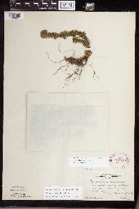 Huperzia lucidula (Michaux) Trevisan 262149[1338807]Sargent, Phillis s.n.1925-04-05 United States, Minnesota, Hennepin, Near the mouth of Nine Mile Creek, S Hennepin Co.;;N;;, 44.824856 -93.313263 |
MIN:Plants | 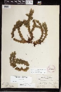 Huperzia lucidula (Michaux) Trevisan 262189[1338855]Butters, F.K. 39991921-05-29 United States, Minnesota, Houston, W of Caledonia, Houston Co.;;;;, 43.63472 -91.49667 |
MIN:Plants | 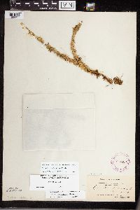 Huperzia lucidula (Michaux) Trevisan 264169[1338822]Holzinger, John s.n.1897-06-10 United States, Minnesota, N. Minn.;;;;, 47.579307 -93.818729 |
MIN:Plants | 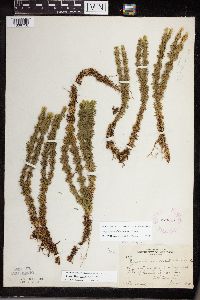 Huperzia lucidula (Michaux) Trevisan 273347[1338758]Rosendahl, C. 60111929-08-11 United States, Minnesota, Cook, W side of Grand Portage Bay;Grand Portage Indian Reservation / North Shore;063N;06E;, 47.962387 -89.683423 |
MIN:Plants | 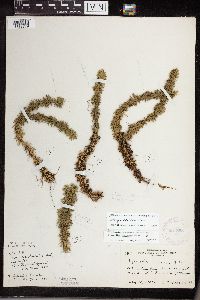 Huperzia lucidula (Michaux) Trevisan 281855[1338779]Rosendahl, C. 64021931-05-10 United States, Minnesota, Rice, Nerstrand Woods. SE Rice Co.;Nerstrand Woods State Park;110N;19W;, 44.341172 -93.111247 |
MIN:Plants | 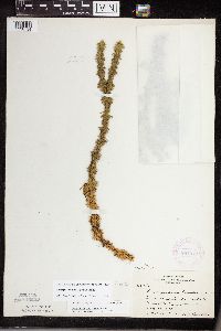 Huperzia lucidula (Michaux) Trevisan 281979[1338734]Rosendahl, C.O. 62211930-08-19 United States, Minnesota, Cook, Head of Clark's Bay, Grand Portage;Grand Portage Indian Reservation / North Shore;064N;07E;, 47.9667 -89.7667 |
MIN:Plants | 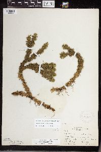 Huperzia lucidula (Michaux) Trevisan 282063[1338838]Rosendahl, C. 61671929-10-18 United States, Minnesota, Washington, About halfway between Bog Lake and Marine Lake, Washington Co.;;;;, 45.214127 -92.862683 |
MIN:Plants | 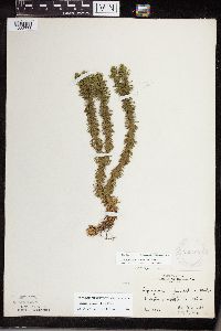 Huperzia lucidula (Michaux) Trevisan 283169[1338778]Rosendahl, C.O. s.n.1932-08-00 United States, Minnesota, Rice, Nerstrand - Rice Co.;;N;;, 44.341909 -93.067988 |
MIN:Plants | 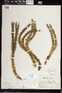 Huperzia lucidula (Michaux) Trevisan 283325[1338762]Butters, F.K. 4461932-07-16 United States, Minnesota, Cook, N shore Clearwater Lake, Cook Co. T65N R1E;Boundary Waters Canoe Area Wilderness / Superior National Forest;065N;01E;, 48.087449 -90.322587 |
MIN:Plants | 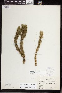 Huperzia lucidula (Michaux) Trevisan 338347[1338816]Burns, G. s.n.1937-10-14 United States, Minnesota, Itasca, Near Cut Foot Sioux, Itasca Co.;Chippewa National Forest / Leech Lake Indian Reservation;N;;, 47.508306 -94.084057 |
MIN:Plants | 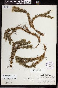 Huperzia lucidula (Michaux) Trevisan 345913[1338745]Lakela, Olga 19201937-05-27 United States, Minnesota, Carlton, St. Louis River terrace, in Jay Cook Park. Carlton Co.;Jay Cooke State Park;048N;16W;, 46.649665 -92.330748 |
MIN:Plants |  Huperzia lucidula (Michaux) Trevisan 347281[1338805]Lakela, Olga 19051937-05-31 United States, Minnesota, Saint Louis, Across the ridge from Peabody's place. Sec.19. Duluth;;N;;, 46.7833 -92.1 |
MIN:Plants |  Huperzia lucidula (Michaux) Trevisan 351060[1338782]Seashore, Mauritz s.n.1932-05-15 United States, Minnesota, Rice, Near Northfield;;N;;, 44.458298 -93.161604 |
MIN:Plants |  Huperzia lucidula (Michaux) Trevisan 354570[1338800]Lakela, Olga 26931938-08-06 United States, Minnesota, Saint Louis, Hwy.61, about 17 mi from Duluth, St. Louis Co.;;N;;, 46.7833 -92.1 |
MIN:Plants |  Huperzia lucidula (Michaux) Trevisan 355703[1338797]Lakela, Olga 28911939-05-28 United States, Minnesota, Saint Louis, On Grand Rapids Rd, about 1/2 mi from the jnc. of Miller Trunk Hwy, 11 mi N of Duluth;;N;;, 46.942517 -92.106579 |
MIN:Plants | 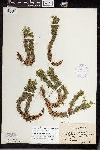 Huperzia lucidula (Michaux) Trevisan 357394[1338740]Rosendahl, C.O. 68271937-08-14 United States, Minnesota, Isanti, Along hwy.65, near Stanchfield, Isanti Co.;;N;;, 45.675094 -93.19083 |
MIN:Plants | 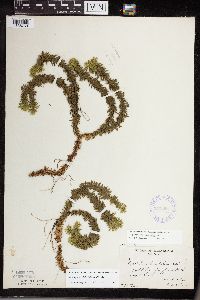 Huperzia lucidula (Michaux) Trevisan 357395[1338769]Burns, G. 2351938-07-25 United States, Minnesota, Cook, S of Royal Lake, T64N R3E. Cook Co.;Superior National Forest;064N;03E;11, 48.05 -90.0167 |
MIN:Plants | 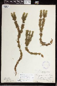 Huperzia lucidula (Michaux) Trevisan 357401[1338763]Butters, F.K. 1481938-07-13 United States, Minnesota, Cook, S of E end of Mountain Lake.;Boundary Waters Canoe Area Wilderness / Superior National Forest;065N;02E;, 48.10737 -90.224172 |
MIN:Plants | 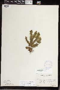 Huperzia lucidula (Michaux) Trevisan 357402[1338767]Burns, G. 3291938-07-27 United States, Minnesota, Cook, Cook Co. Portage trail at outlet of Royal Lake, T65N R3E;Boundary Waters Canoe Area Wilderness / Superior National Forest;065N;03E;, 48.05 -90.0167 |
MIN:Plants |  Huperzia lucidula (Michaux) Trevisan 357403[1338755]Burns, G. 3671938-08-01 United States, Minnesota, Cook, Cook Co. Cliff ("Mountain Lookout") near lodge on McFarland L. T64N R3E;Superior National Forest;064N;03E;, 47.726653 -90.386005 |
MIN:Plants |  Huperzia lucidula (Michaux) Trevisan 357447[1338820]Rosendahl, C. 68051937-06-28 United States, Minnesota, Winona, N end of Gwinn's Bluff, Winona Co.;Great River Bluffs State Park;106N;05W;, 43.946353 -91.399309 |
MIN:Plants |  Huperzia lucidula (Michaux) Trevisan 358801[1338796]Gilbert, H. 351923-05-12 United States, Minnesota, Saint Louis, Duluth;;N;;, 46.7833 -92.1 |
MIN:Plants |  Huperzia lucidula (Michaux) Trevisan 362073[1338771]Moyle, J. 34671940-07-17 United States, Minnesota, Lake, Along Gooseberry R. Lake Co.;Gooseberry Falls State Park / North Shore;054N;09W;00, 47.146872 -91.463229 |
MIN:Plants | 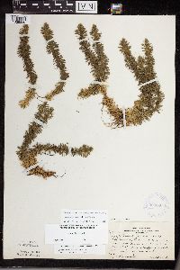 Huperzia lucidula (Michaux) Trevisan 366080[1338830]Rosendahl, C. 74221940-05-20 United States, Minnesota, Winona, N end of Gwinn's Bluff, near base, short distance S of old red barn; Winona Co.;Great River Bluffs State Park;106N;05W;, 43.946353 -91.399309 |
MIN:Plants | 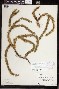 Huperzia lucidula (Michaux) Trevisan 374014[1338781]Linnaean Club, U of M, 991939-05-21 United States, Minnesota, Rice, Nerstrand Woods. Rice Co.;Nerstrand Woods State Park;110N;19W;, 44.341172 -93.111247 |
MIN:Plants | 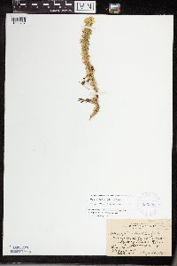 Huperzia lucidula (Michaux) Trevisan 383328[1338737]Rosendahl, C.O. 68531937-08-26 United States, Minnesota, Itasca, Along Hwy. #1, halfway between Effie and Toga, Itasca Co.;Chippewa National Forest;N;;, 47.808871 -93.384789 |
MIN:Plants | 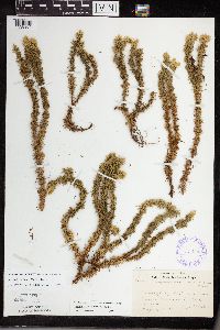 Huperzia lucidula (Michaux) Trevisan 385904[1338804]Lakela, Olga 55191944-05-22 United States, Minnesota, Saint Louis, Creek along Hwy.61, near French River, St. Louis Co.;;N;;, 46.942992 -91.949958 |
MIN:Plants |  Huperzia lucidula (Michaux) Trevisan 387739[1338775]Moore, J.W. 198901947-10-15 United States, Minnesota, Lake, Lake Co. Baptism River State Park [=Tettegouche];North Shore / Tettegouche State Park;056N;07W;00, 47.33958 -91.198054 |
MIN:Plants |  Huperzia lucidula (Michaux) Trevisan 387744[1338766]Butters, F.K. 7901944-07-30 United States, Minnesota, Cook, Cook Co. Between Partridge Lake and South Lake, T65N R1W;Boundary Waters Canoe Area Wilderness / Superior National Forest;065N;01W;, 48.084387 -90.488868 |
MIN:Plants |  Huperzia lucidula (Michaux) Trevisan 387745[1338828]Rosendahl, C. 75011942-05-10 United States, Minnesota, Winona, Immediately above first vertical sandstone ledge, 100 ft S of old barn. Gwinn's Bluff, Winona Co.;Great River Bluffs State Park;106N;05W;, 43.955293 -91.410815 |
MIN:Plants |  Huperzia lucidula (Michaux) Trevisan 391661[1338777]Rosendahl, C. s.n.1946-11-15 United States, Minnesota, Rice, Rice Co. Nerstrand Woods;Nerstrand Woods State Park;110N;19W;, 44.341172 -93.111247 |
MIN:Plants |  Huperzia lucidula (Michaux) Trevisan 393249[1338764]Ownbey, Gerald 983c1948-08-11 United States, Minnesota, Cook, Cook Co. About 1 mi NE of Cook Co. line, Hwy. #61;Finland State Forest / North Shore;058N;05W;, 47.736887 -90.37079 |
MIN:Plants |  Huperzia lucidula (Michaux) Trevisan 405341[1338803]Lakela, Olga 79341949-05-01 United States, Minnesota, Saint Louis, Prairie Lake, SW area of St. Louis Co.;;050N;20W;, 46.79124 -92.904888 |
MIN:Plants |  Huperzia lucidula (Michaux) Trevisan 407308[1295034]Lakela, Olga 92611949-08-06 United States, Minnesota, Saint Louis, Lake Hegman portage. Echo Trail, N of Ely [Superior National Forest; T64N;R12W;S7], 48.116014 -92.14764 |
MIN:Plants |  Huperzia lucidula (Michaux) Trevisan 407564[1338799]Lakela, Olga 81791949-06-11 United States, Minnesota, Saint Louis, Prairie Lake, SW St. Louis Co.;;050N;20W;, 46.79124 -92.904888 |
MIN:Plants |  Huperzia lucidula (Michaux) Trevisan 419496[1338801]Lakela, Olga 114921950-08-20 United States, Minnesota, Saint Louis, Curtain Falls, Crooked Lake, St. Louis Co.;Boundary Waters Canoe Area Wilderness / Superior National Forest;066N;12W;, 48.203274 -91.857461 |
MIN:Plants |  Huperzia lucidula (Michaux) Trevisan 419962[1338821]Lakela, Olga 118901950-08-30 United States, Minnesota, Saint Louis, At Palmer, St. Louis Co.;;N;;, 47.5833 -92.5 |
MIN:Plants |  Huperzia lucidula (Michaux) Trevisan 420016[1338776]Lakela, Olga 118641950-08-30 United States, Minnesota, Lake, At Encampment River, Lake Co. [assuming along highway 61 as other collections];North Shore;053N;10W;11, 47.0931 -91.575835 |
MIN:Plants |  Huperzia lucidula (Michaux) Trevisan 421621[1338770]Ahlgren, Clifford 11451950-08-11 United States, Minnesota, Saint Louis, Lake Co. At Curtain Falls, Crooked Lake;Boundary Waters Canoe Area Wilderness / Superior National Forest;066N;12W;, 48.203274 -91.857461 |
MIN:Plants |  Huperzia lucidula (Michaux) Trevisan 427450[1338827]Smith, Welby 148581988-08-12 United States, Minnesota, Washington, Washington Co. Belwin Outdoor Education Laboratory, about 1/2 mi W of St. Mary's Point; NE1/4 NE1/4 sec.15, T28N R20W;Belwin Outdoor Education Laboratory;028N;20W;15, 44.917836 -92.784221 |
MIN:Plants |  Huperzia lucidula (Michaux) Trevisan 432817[1338752]Harris, Fred 940121994-05-23 United States, Minnesota, Olmsted, Olmsted Co.; Whitewater WMA; NW slope along Logan Branch of Whitewater river; SW1/4 of NE1/4 of SW1/4 Sect. 3 T107n R11W;Whitewater Wildlife Management Area;107N;11W;3, 44.097269 -92.132956 |
MIN:Plants |  Huperzia lucidula (Michaux) Trevisan 442029[1338747]Moore, John W. 181931945-08-21 United States, Minnesota, Carlton, Carlton Co. Along the St. Louis River, Jay Cooke State Park;Jay Cooke State Park;048N;16W;, 46.649665 -92.330748 |
MIN:Plants |  Huperzia lucidula (Michaux) Trevisan 442282[1338786]Lakela, Olga 123641951-05-30 United States, Minnesota, Saint Louis, N of Floodwood, Hwy.2, St. Louis Co.;;N;;, 46.92911 -92.919648 |
MIN:Plants | 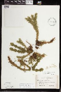 Huperzia lucidula (Michaux) Trevisan 442306[1338802]Lakela, Olga 137811951-09-14 United States, Minnesota, Saint Louis, Crane Lake, St. Louis Co.;Superior National Forest;067N;17W;, 48.2833 -92.4667 |
MIN:Plants | 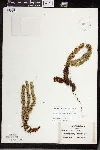 Huperzia lucidula (Michaux) Trevisan 442499[1338794]Lakela, Olga 135021951-07-24 United States, Minnesota, Saint Louis, Pike River Rd, S of Tower, St. Louis Co.;;N;;, 47.8 -92.2667 |
MIN:Plants | 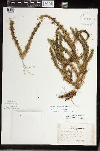 Huperzia lucidula (Michaux) Trevisan 442674[1338851]Lakela, Olga 126761951-06-25 United States, Minnesota, Saint Louis, At Eagles Nest Lake on Hwy. #1 SW of Ely, St. Louis Co.;;N;;, 47.9 -91.8667 |
MIN:Plants | 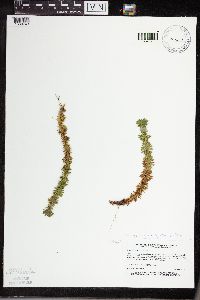 Huperzia lucidula (Michaux) Trevisan 453647[1338743]Boe, J. 940915031994-09-15 United States, Minnesota, Cass, Chippewa National Forest. Cass Co.; north of Schoolcraft State Park near MCBS Site 73. Chipp. Nat. Forest ECS transect 09; T 142N R 25W NW1/4 of N Cass Co.; north of Schoolcraft State Park near MCBS Site 73. Chipp. Nat. Forest ECS transect 09; T 142N R 25W NW1/4 of NE1/4 of Sec 2 [Schoolcraft State Park is in T143N]. 143N 25W 2, 47.134092 -93.845941 |
MIN:Plants |  Huperzia lucidula (Michaux) Trevisan 459067[1295013]Lee, Michael D. MDL4111994-05-10 United States, Minnesota, Fillmore, 1.5 miles SE of Whalan; T103N R09W SW1/4 of SW1/4 of Sec 15 [Dorer Memorial Hardwood State Forest], 43.724368 -91.900099 |
MIN:Plants |  Huperzia lucidula (Michaux) Trevisan 462517[1338852]Lakela, Olga 158151952-09-11 United States, Minnesota, Saint Louis, St. Louis Co. Sand Point Lake W of Harrison's Narrows;Voyageurs National Park;N;;, 48.483546 -92.838098 |
MIN:Plants |  Huperzia lucidula (Michaux) Trevisan 462683[1338791]Lakela, Olga 142691952-06-19 United States, Minnesota, Saint Louis, St. Louis Co. S shore of Namakan Lake, near Gull Island;Voyageurs National Park;N;;, 48.433517 -92.705646 |
MIN:Plants |  Huperzia lucidula (Michaux) Trevisan 463355[1338819]Lakela, Olga 153331952-08-01 United States, Minnesota, Saint Louis, St. Louis Co. Isle of Pines, Vermilion Lake;Superior National Forest;N;;, 47.891581 -92.366824 |
MIN:Plants | 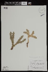 Huperzia lucidula (Michaux) Trevisan 473653[1295008]Myhre, K.M. 15651992-04-06 United States, Minnesota, Cass, about 5 miles South of Walker; along the Shingobee River; T 141N R 31W SW1/4 of NW1/4 of sec 16 [Chippewa National Forest], 47.033848 -94.615967 |
MIN:Plants | 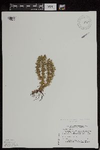 Huperzia lucidula (Michaux) Trevisan 477994[1295012]Myhre, K.M. 17171992-05-07 United States, Minnesota, Cass, located on the south side of Little Thunder Lake, 1 mile northeast of Thunder Lake; T 140N R 26W SW1/4 of SW1/4 of sec 2, 46.964811 -93.940951 |
MIN:Plants | 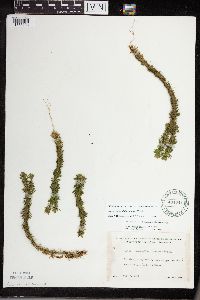 Huperzia lucidula (Michaux) Trevisan 491741[1338798]Lakela, Olga 166051953-08-06 United States, Minnesota, Saint Louis, St. Louis Co. Bay of Lac La Croix S of Lac La Croix Resort;Boundary Waters Canoe Area Wilderness / Superior National Forest;N;;, 48.3333 -92.1167 |
MIN:Plants | 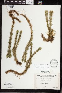 Huperzia lucidula (Michaux) Trevisan 491787[1338789]Lakela, Olga 165421953-08-04 United States, Minnesota, Saint Louis, St. Louis Co. Hwy.73, N of Chisholm;;N;;, 47.489097 -92.883796 |
MIN:Plants | 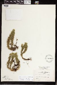 Huperzia lucidula (Michaux) Trevisan 526918[1338772]Lakela, Olga 181991954-08-14 United States, Minnesota, Lake, above Chippewa Lake, Lake Co.;Boundary Waters Canoe Area Wilderness / Superior National Forest;066N;11W;31, 48.156545 -91.788226 |
MIN:Plants | 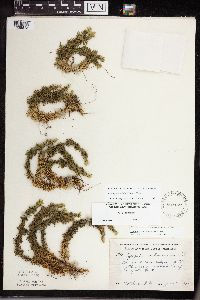 Huperzia lucidula (Michaux) Trevisan 529162[1338818]Rosendahl, C. 79451951-06-14 United States, Minnesota, Winona, Winona Co. At the N base of Gwinn's Bluff.;Great River Bluffs State Park;106N;05W;, 43.942065 -91.4667 |
MIN:Plants | 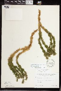 Huperzia lucidula (Michaux) Trevisan 543095[1338783]Lakela, Olga 220661957-08-17 United States, Minnesota, Lake, Lake Co. 14 mi N of Two Harbors;Superior National Forest;N;;, 47.225377 -91.670732 |
MIN:Plants | 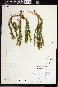 Huperzia lucidula (Michaux) Trevisan 543240[1338773]Lakela, Olga 224671957-09-13 United States, Minnesota, Lake, Lake Co. Snow Bank Lake;Boundary Waters Canoe Area Wilderness / Superior National Forest;N;;, 47.988692 -91.416956 |
MIN:Plants | 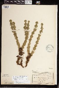 Huperzia lucidula (Michaux) Trevisan 55290[1338768]MacMillan, C. 1361901-08-18 United States, Minnesota, Cook, N - S Lake Portage, Cook Co.;Boundary Waters Canoe Area Wilderness / Superior National Forest;065N;02W;, 48.099056 -90.505101 |
MIN:Plants | 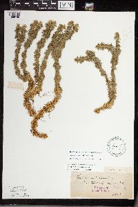 Huperzia lucidula (Michaux) Trevisan 55291[1338735]Roberts, Thomas s.n.1879-08-25 United States, Minnesota, Cook, Carlton's Peak, Cook Co.;North Shore / Superior National Forest;T059N R04W S27, 47.9167 -90.55 |
MIN:Plants | 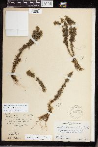 Huperzia lucidula (Michaux) Trevisan 55292[1338788]Butters, F.K. s.n.1918-06-01 United States, Minnesota, Saint Louis, 10 mi W of Duluth.;;;;, 46.783078 -92.317992 |
MIN:Plants | 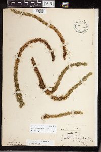 Huperzia lucidula (Michaux) Trevisan 55293[1338795]Rosendahl, C. 23681909-08-28 United States, Minnesota, Saint Louis, Near Pelican Lake (St. Louis Co.);;N;;, 48.07265 -92.934264 |
MIN:Plants | 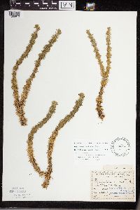 Huperzia lucidula (Michaux) Trevisan 55294[1338813]Sandberg, John s.n.1891-08-00 United States, Minnesota, Aitkin, [no further data];;;;, 46.476315 -93.610352 |
MIN:Plants | 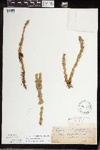 Huperzia lucidula (Michaux) Trevisan 55295[1338765]Roberts, Thomas s.n.1879-08-21 United States, Minnesota, Cook, Devil`s Track River. Cook Co, near Gd. Marais;North Shore / Superior National Forest;061N;01E;, 47.8167 -90.4167 |
MIN:Plants | 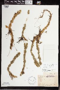 Huperzia lucidula (Michaux) Trevisan 55296[1338848]Arthur, J. B3091886-07-23 United States, Minnesota, Saint Louis, St. Louis R. [other collections indicated St. Louis Co.];;;;, 47.589862 -92.461466 |
MIN:Plants | 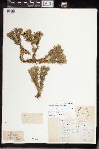 Huperzia lucidula (Michaux) Trevisan 55297[1338751]Butters, F.K. 34581918-05-03 United States, Minnesota, Goodhue, N of Welch, Goodhue Co.;Dorer Memorial Hardwood State Forest;;;, 44.576126 -92.738532 |
Google Map
Google Maps is a web mapping service provided by Google that features a map that users can pan (by dragging the mouse) and zoom (by using the mouse wheel). Collection points are displayed as colored markers that when clicked on, displays the full information for that collection. When multiple species are queried (separated by semi-colons), different colored markers denote each individual species.