University of Minnesota
http://www.umn.edu/
612-625-5000
http://www.umn.edu/
612-625-5000
Minnesota Biodiversity Atlas
Bell Museum
Dataset: MIN-Plants
Taxa: Trifolium
Search Criteria: excluding cultivated/captive occurrences
Bell Museum plants | |
 MIN:Plants |  436358[1079264]Myhre, K. 38911993-06-22 United States, Minnesota, Pine, Pine Co. Located 2 mi S of Sturgeon Lake; T45N R19W NE1/4 of SW1/4 of Sec 33;;045N;19W;33, 46.338863 -92.7512491 |
MIN:Plants |  436476[1079319]Smith, Welby 195501991-07-16 United States, Minnesota, Koochiching, Koochiching State Forest. Koochiching County...On the north side of TH 65, about 18 miles northwest of Silverdale... T 65N R 24W SE1/4 of NE1/4 of Sec 3. 065N 24W 3, 48.1500015 -93.4186096 |
MIN:Plants |  441048[1079262]Myhre, K. 49511994-06-12 United States, Minnesota, Itasca, Itasca Co.; located 3 miles east of Cedar Lake; T 148N R 25W SW1/4 of SW1/4 of Sec 7;Chippewa National Forest;148N;25W;20, 47.6204859 -93.8689259 |
MIN:Plants |  441859[1079233]Cholewa, A. 25762000-06-25 United States, Minnesota, Anoka, Anoka Co, T34N R23W Sec.32, East Bethel, frontage road on east side of highway 65.;;034N;23W;32, 45.3920036 -93.2344179 |
MIN:Plants |  444925[1079287]Moore, John; et al. 175761945-07-08 United States, Minnesota, Rock, 4 mi NNW of Luverne;;;;, 43.70769 -96.24315 |
MIN:Plants |  446315[1079252]Moore, John; Huff, N. 187071946-06-20 United States, Minnesota, Pipestone, Pipestone;;106N;46W;, 43.997068 -96.313414 |
MIN:Plants |  446420[1079327]Moore, John 173951945-06-21 United States, Minnesota, Pennington, 6 mi. W of Thief River Falls;;N;;, 48.119934 -96.321024 |
MIN:Plants |  449342[1079251]Moore, John; et al. 174011945-06-28 United States, Minnesota, Kanabec, Kanabec Co. 8 1/2 mi S of Mora;;038N;24W;, 45.753831 -93.293835 |
MIN:Plants | 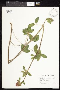 453208[1079299]Smith, Welby 211101992-07-28 United States, Minnesota, Fillmore, Dorer Memorial Hardwood State Forest. Fillmore Co.; In the Root River Valley, about 0.5 mile south of Peterson (about 3/8 mile west of mile post 23 on the Root River Trail). Gravel pit...T 104N R 8W SW1/4 of SE1/4 of Sec 30. 104N 08W 30, 43.7791672 -91.8386078 |
MIN:Plants | 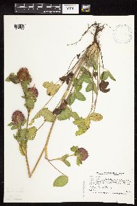 456629[1079204]Smith, Welby 213271992-08-10 United States, Minnesota, Wadena, Wadena Co.; between Trunk Highway 10 and the Burlington Northern Railroad tracks, about 3 mi SE of Wadena (town); Wadena Co.; between Trunk Highway 10 and the Burlington Northern Railroad tracks, about 3 mi SE of Wadena (town); T134N R35W SE1/4 of SW1/4 of SEc 14. 134N 35W 14, 46.4158325 -95.0627747 |
MIN:Plants | 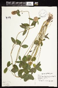 457065[1079210]Smith, Welby 189661991-06-25 United States, Minnesota, Todd, Grey Eagle Wildlife Management Area. Todd Co.; Grey Eagle State Wildlife Management Area, about 3 miles west of Grey Eagle; Todd Co.; Grey Eagle State Wildlife Management Area, about 3 miles west of Grey Eagle; T 127N R 33W SW1/4 of SE1/4 of sec 10. 127N 33W 10, 45.8191681 -94.815834 |
MIN:Plants | 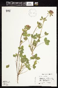 458994[1079211]Darveaux, B. s.n.1991-07-15 United States, Minnesota, Steele, Owatonna, Steele Co. Rt 14 heading east off of Hwy 35, near 176 mile marker on left side of road;;107N;20W;, 44.095575 -93.245954 |
MIN:Plants | 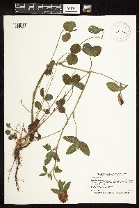 475852[1079232]Smith, Welby 196121991-07-17 United States, Minnesota, Itasca, Itasca Co.; Scenic State Park, about 3 miles southeast of Big Fork; T 60N R 26W NE1/4 of NE1/4 of sec 1;Scenic State Park;060N;26W;1, 47.7213898 -93.5805588 |
MIN:Plants | 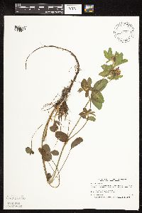 506863[1079371]Smith, Welby 170091990-06-25 United States, Minnesota, Steele, Aurora Wildlife Management Area. Steele Co. Aurora State Wildlife Management Area. On the W side of U.S. Trunk Hwy 218, about 9 mi SE of Owatonna; Steele Co. Aurora State Wildlife Management Area. On the W side of U.S. Trunk Hwy 218, about 9 mi SE of Owatonna; T106N R19W NE1/4 of NW1/4 of sEc 28. 106N 19W 28, 43.9627762 -93.1175003 |
MIN:Plants | 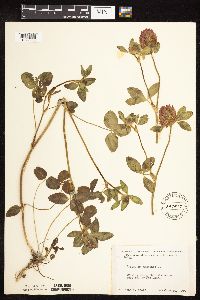 507207[1079358]Moore, John 206311950-06-19 United States, Minnesota, Martin, Along the lake shore W end of Fox Lake;;N;;, 43.67528 -94.721522 |
MIN:Plants | 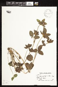 515544[1079374]Smith, Welby 168571990-06-18 United States, Minnesota, Waseca, Senn-Rich Wildlife Management Area. Waseca Co.; Senn-Rich State Wildlife Management Area, about 5 miles south of Waseca; Waseca Co.; Senn-Rich State Wildlife Management Area, about 5 miles south of Waseca; T 106N R 22W SE1/4 of NW1/4 of Sec 8. 106N 22W 8, 44.002224 -93.4977798 |
MIN:Plants |  518970[1079208]Smith, Welby 209941992-07-16 United States, Minnesota, Pennington, Pennington County...on the west side of County Road 73, about 4.5 miles northwest of the center of Thief River Falls. In abandoned gravel pit...T 154N R 44W NE1/4 of NE1/4 of sec. 13. 154N 44W 13, 48.1638889 -96.2405556 |
MIN:Plants |  519010[1079370]Smith, Welby 154711989-06-25 United States, Minnesota, Freeborn, Freeborn Co.; Helmer Myre State Park, about 2 miles southeast of Albert Lea; NW1/4 NE1/4 sec.23, T102N R21W;Myre Big Island State Park;102N;21W;23, 43.6223849 -93.3187032 |
MIN:Plants |  519020[1079209]Smith, Welby 192731991-07-09 United States, Minnesota, Koochiching, Pine Island State Forest. Koochiching Co.; about 5 miles southwest of Big Falls. Along Hickes Ridge Road, about 0.5 mil north of US Hwy 71. Abandoned gravel pit; T154N R25W NE1/4 of SW1/4 of [etc. 154N 25W 30, 48.127224 -93.8974991 |
MIN:Plants |  520318[1079205]Smith, Welby 193921991-07-10 United States, Minnesota, Koochiching, Koochiching County...about 2 miles S-SW of Little Fork. Abandoned gravel pit...T68N R25W T68N R25W NW1/4 of NW1/4 of Sec 20. 068N 25W 20, 48.3713875 -93.5875015 |
MIN:Plants |  520477[1079373]Smith, Welby 169031990-06-20 United States, Minnesota, Dodge, Dodge Co.; Dodge Center Creek Park. On the N side of Dodge Center Creek, and 1 mi W of the town of Dodge Center; Dodge Co.; Dodge Center Creek Park. On the N side of Dodge Center Creek, and 1 mi W of the town of Dodge Center; T107N R17W SW1/4 of SW1/4 of Sec 28. 107N 17W 28, 44.040554 -92.8780518 |
MIN:Plants |  520591[1079203]Smith, Welby 187691991-06-11 United States, Minnesota, Aitkin, Hill River State Forest. Aitkin Co.; Hill River State Forest, about 5 mi E of Hill City; along an old logging road; Aitkin Co.; Hill River State Forest, about 5 mi E of Hill City; along an old logging road; T52N R25W SW1/4 of NE1/4 of Sec 23. 052N 25W 23, 46.9805565 -93.4805527 |
MIN:Plants |  526648[1079284]Merrell, Ted s.n.1947-09-28 United States, Minnesota, Rice, Northfield;;N;;, 44.4496671 -93.1708471 |
MIN:Plants |  542516[1079356]Moore, John 218271954-07-20 United States, Minnesota, Wilkin, 2.5 mi S of Breckenridge;;N;;, 46.227375 -96.588129 |
MIN:Plants |  542720[1079355]Moore, John 217171952-06-04 United States, Minnesota, Brown, At old clay pits at Springfield;;N;;, 44.210582 -95.078377 |
MIN:Plants |  542945[1079359]Lakela, Olga; Davidson, Donald 215421957-07-24 United States, Minnesota, Cook, [no further data];Boundary Waters Canoe Area Wilderness / Superior National Forest;063N;05W;35, 47.9018236 -89.7757529 |
MIN:Plants |  551416[1079330]Cotter, Shirley 6671948-08-06 United States, Minnesota, Clearwater, Biological Station, Itasca State Park.;Itasca State Park;143N;36W;, 47.226329 -95.194754 |
MIN:Plants |  553719[1079297]Moore, John 227021955-07-28 United States, Minnesota, Clay, 4.5 mi E of Hawley;;N;;, 46.880754 -96.221424 |
MIN:Plants |  553894[1079298]Moore, John 224471955-05-31 United States, Minnesota, Sibley, Along the W shore of High Island Lake at New Auburn;;114N;28W;, 44.673798 -94.223984 |
MIN:Plants |  558517[1079249]Moore, John; Moore, Marjorie 235351957-09-19 United States, Minnesota, Isanti, NW1/4 Sec. 15, Athens Twp, Cedar Creek Forest.;Cedar Creek National History Area;034N;23W;15, 45.4358955 -93.1940736 |
MIN:Plants |  566275[1079280]Moore, John; Bernardini, J. 242641958-09-17 United States, Minnesota, Blue Earth, Roadside N of Lily Lake, Lake Crystal;;N;;, 44.121662 -94.223474 |
MIN:Plants |  566556[1079281]Moore, John; Heig, V. 240021958-09-09 United States, Minnesota, Kittson, Creek bank 1/4 mi N of Hallock;;N;;, 48.786188 -96.948507 |
MIN:Plants |  566586[1079277]Moore, John 238701958-06-12 United States, Minnesota, Kittson, Along the banks of the river at Hallock;;N;;, 48.775784 -96.940267 |
MIN:Plants |  572631[1079248]Moore, John; Baker, Gary 254571961-06-20 United States, Minnesota, Faribault, 1 mi. SE of Wells;;N;;, 43.73235 -93.708135 |
MIN:Plants |  572826[1079292]Moore, John 253751961-06-06 United States, Minnesota, Houston, Church grounds at the Evangelical Church of Peace, E of Freeburg;;102N;04W;, 43.611081 -91.364304 |
MIN:Plants |  572833[1079247]Moore, John; Baker, Gary 254161961-06-17 United States, Minnesota, Blue Earth, Roadside, 1 mi. S of St. Clair.;;N;;, 44.075156 -93.85125 |
MIN:Plants |  588095[1079343]Marion, J. s.n.1982-00-00 United States, Minnesota, Cook, Cook Co, North Shore of Lake Superior, ca. 200 ft. from lakeshore;North Shore;;;, 47.46396 -91.02551 |
MIN:Plants |  594687[1079333]Moore, John; Goodwin, D. 521946-10-19 United States, Minnesota, Crow Wing, Along the S shore of Rabbit Lake.;;N;;, 46.528239 -93.924547 |
MIN:Plants |  595353[1079332]Cahoon, E. 811956-07-08 United States, Minnesota, Brown, Och's Clay Pit, ca. 1 mi. SW of Springfield.;;N;;, 44.223217 -95.008622 |
MIN:Plants |  602188[1079331]Westkaemper, Remberta s.n.1966-06-00 United States, Minnesota, Stearns, Stearns Co. St. Joseph;;124N;29W;, 45.564083 -94.30917 |
MIN:Plants |  616519[1079347]Moore, John; Moore, Marjorie 1411969-06-17 United States, Minnesota, Crow Wing, S end of Chandler Lake; SW1/4 Sec. 22 Garrison Twp.;;N;;22, 46.272405 -93.871902 |
MIN:Plants | 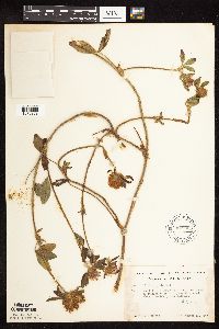 618925[1079363]Monserud, W. 2681953-10-11 United States, Minnesota, Cook, Cook Co.; About 1 mile west of Hovland, below highway 61;Grand Portage State Forest / North Shore;062N;03E;, 47.828408 -89.990858 |
MIN:Plants | 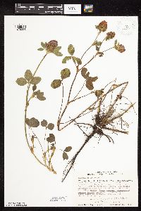 670685[1079334]Heitlinger, M. 3781971-09-10 United States, Minnesota, McLeod, Schaefer Prairie, The Nature Conservancy. Schaefer Prairie: SE1/4 of Sec. 34, T115N, R29W. Just S of the marsh W of the prominent N-S ridge. Old field S of pra Schaefer Prairie: SE1/4 of Sec. 34, T115N, R29W. Just S of the marsh W of the prominent N-S ridge. Old field S of prairie.. 115N 29W 34, 44.7250496 -94.3049103 |
MIN:Plants | 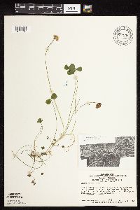 680933[1079212]Swanson, Steven 15271975-07-17 United States, Minnesota, Houston, Mississippi River (Navigation Pool #8), Houston Co, site 36;Upper Mississippi National Wildlife Refuge;N;;, 43.841616 -91.279998 |
MIN:Plants | 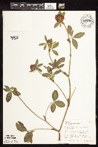 681679[1079367]Gustitus, J. 151973-09-28 United States, Minnesota, Washington, Washington Co. O'Brien State Park. Along trail above St. Croix R, N of canoe campgrounds;William O'Brien State Park;032N;19W;, 45.223522 -92.762609 |
MIN:Plants | 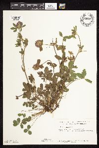 685127[1079336]Stassen, Carol 1861977-07-06 United States, Minnesota, Lyon, Camden State Park; T110N, R42W, Sec. 5. Along trail to Lynd Trading Post site.;Camden State Park;110N;42W;5, 44.3631806 -95.9274434 |
MIN:Plants | 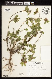 687121[1079342]Wheeler, Gerald; Glaser, Paul 15481977-06-04 United States, Minnesota, Itasca, Site 37. SE1/4 SE1/4 Sec. 20, T55N, R26W; ca. 5 mi. W of Grand Rapids.;;055N;26W;20, 47.2325665 -93.6706029 |
MIN:Plants | 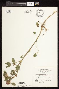 689264[1079229]Marshall, John s.n.1966-06-13 United States, Minnesota, Washington, Washington Co.; Point Douglas;;026N;20W;, 44.759124 -92.821758 |
MIN:Plants | 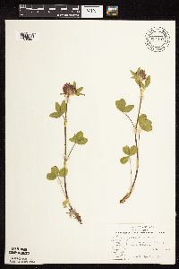 691187[1079362]Sperling, C. 2411976-06-08 United States, Minnesota, Douglas, 4 mi E of Kensington;;N;;, 45.777985 -95.613116 |
MIN:Plants |  695915[1079326]Clemants, Steven 9291977-09-17 United States, Minnesota, Crow Wing, West shore road, Crosslake. T137N, R27W, NW1/4 Sec. 30.;;137N;27W;30, 46.6531384 -94.1459091 |
MIN:Plants |  695963[1079323]Clemants, Steven 8991977-09-01 United States, Minnesota, Olmsted, Dorer Memorial Hardwood State Forest. Olmsted Co. Simpson's Bluff, 3 mi. S of Simpson on Co. Rd. 1. North Branch Root River. T105N, R13W, East Center Sec. 2 Olmsted Co. Simpson's Bluff, 3 mi. S of Simpson on Co. Rd. 1. North Branch Root River. T105N, R13W, East Center Sec. 20.. 151N 13W 20, 43.9274947 -92.3484177 |
MIN:Plants |  698908[1079351]Sather, Nancy; et al. 5041977-08-16 United States, Minnesota, Saint Louis, St. Louis Co. Grounds on Burley's Resort on White Iron Lake; SW1/4 NE1/4 Sec. 12 T62N R12W;Superior National Forest;062N;12W;12, 47.8689795 -91.809651 |
MIN:Plants |  700895[1079350]Dorio, J. 7951977-08-29 United States, Minnesota, Morrison, Morrison Co.; Lake Alexander, ca. 7 mi N of Randall on co. rd 6 [co. #1?]; T131N R30W Sec. 6;Lake Alexander Preserve, The Nature Conservancy;131N;30W;6, 46.18707 -94.50623 |
MIN:Plants |  701048[1079349]Dorio, J. 7851977-08-16 United States, Minnesota, Morrison, Ripley Esker, ca. 3 mi NE of Camp Ripley Junction; T42N R31W Sec. 19;Ripley Esker Scientific Natural Area;042N;31W;19, 46.1062834 -94.30299 |
MIN:Plants |  710080[1079365]Wheeler, Gerald 51111979-10-06 United States, Minnesota, Le Sueur, Le Sueur Co. Approx. 1 mi SW of Kasota; on bluff overlooking the Minnesota River, High Lime Prairie; T109N R26W Sec. 6;East Minnesota River Wildlife Management Area;109N;26W;6, 44.3626183 -93.939379 |
MIN:Plants |  712156[1079213]Smith, Welby 19001979-09-13 United States, Minnesota, Wright, Lake Marie State Park, ca. 1/4 mi NW of the jnc of co. rd 111 and 39; T121N R26W SE1/4 NE1/4 Sec. 10;Lake Maria State Park;121N;26W;10, 45.3039609 -93.9428922 |
MIN:Plants |  715733[1079308]Clausen, B. 1061977-09-20 United States, Minnesota, Hubbard, Lake Hattie SE1/4 SW1/4 Sec. 24, T144N, R35W.;;144N;35W;24, 47.2758346 -95.0570514 |
MIN:Plants | 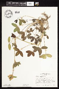 715734[1079307]Clausen, B. 1021977-09-20 United States, Minnesota, Hubbard, Lake Hattie, SE1/4 SW1/4 Sec. 24, T144N, R35W.;;144N;35W;24, 47.2758346 -95.0570514 |
MIN:Plants | 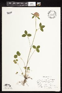 717479[1079283]Mathisen, Ron 1151979-07-09 United States, Minnesota, Hubbard, Spearhead Lake Preserve;Spearhead Lake Preserve (Audubon);145N;34W;, 47.372044 -94.95883 |
MIN:Plants | 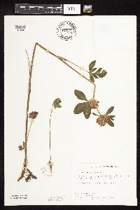 717591[1079306]Farrell, P. 561979-06-25 United States, Minnesota, Norman, Frenchman's Bluff: (TNC) 2.5 mi. N of Flom, frac. of Sec. 18, T143N, R43W.;Frenchmans Bluff Scientific Natural Area;143N;43W;18, 47.2019677 -96.1838932 |
MIN:Plants | 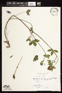 721145[1079353]Lustig, K. 7041979-06-11 United States, Minnesota, Sherburne, Clear Lake-Mississippi Scenic and Recreational River SNA, 12 mi SE of St. Cloud; Sec. 14, 22, 23 T34N R30W;Clear Lake Scientific Natural Area;034N;30W;, 45.4362154 -94.0372393 |
MIN:Plants |  722815[1079214]Lustig, K. 4861979-06-14 United States, Minnesota, Anoka, Anoka County...Boot Lake SNA, 18 mi SE of Cambridge; Sec. 17, 18, 19, 20 T33N R22W;Boot Lake Scientific Natural Area;033N;22W;00, 45.34066 -93.08146 |
MIN:Plants |  727357[1079215]Ottoson, S. 1301979-08-16 United States, Minnesota, Clay, Clay County Bicentennial Prairie, 4 mi SE of Felton; SW1/4 Sec. 5 T141N R45W;Felton Prairie-Bicentennial Prairie Scientific Natural Area;141N;45W;5, 47.0567136 -96.4173556 |
MIN:Plants |  728058[1079245]Farrell, P.; et al. 701979-06-26 United States, Minnesota, Polk, Pembina Trail Preserve Scientific Natural Area. Polk County...Pembina Trail Preserve...6 1/2 mi. E of Harold, all sec. 36, frac. sec, 25, 30, 31, T149N, R45W, frac. sec. 1, 2, T148N, R45W.. , 47.6660064 -96.3343338 |
MIN:Plants |  729185[1079243]Berlin, N. 891979-06-22 United States, Minnesota, Goodhue, Wacouta Pond Natural Area, The Nature Conservancy. Wacouta Pond Natural Area: 5 mi. SE of Red Wing. Hwy. 61 roadside. Portions of: Sec. 6, T112N, R13W and Sec. 31, 32, Wacouta Pond Natural Area: 5 mi. SE of Red Wing. Hwy. 61 roadside. Portions of: Sec. 6, T112N, R13W and Sec. 31, 32, T113N, R13W.. N , 44.5351457 -92.4198697 |
MIN:Plants |  729802[1079244]Phelps, V. 811980-07-09 United States, Minnesota, Pine, Pine Co. Kettle River Natural Area: 5.5 mi. E of Hinckley. SW1/4 NW1/4 Sec. 23, T41N, R20W.;Kettle River Scientific Natural Area / Sandstone National Wildlife Refuge;041N;20W;23, 46.0186087 -92.8357974 |
MIN:Plants |  734573[1079235]Severson, M. 2341980-06-03 United States, Minnesota, Clay, Bluestem Prairie: 13 mi. E of Moorhead. SE1/4 NE1/4 Sec. 15, T139N, R46W.;Bluestem Prairie Scientific Natural Area;139N;46W;15, 46.8549481 -96.4734033 |
MIN:Plants |  734772[1079242]Severson, M. 2801980-06-11 United States, Minnesota, Becker, Green Water Lake Natural Area: 5 mi. W of Ponsford. NE1/4 SE1/4 Sec. 33, T141N, R38W.;Greenwater Lake Scientific Natural Area / White Earth Indian Reservation;141N;38W;33, 46.9838935 -95.4976994 |
MIN:Plants |  738375[1079217]Galatowitsch, S. 2841982-06-22 United States, Minnesota, Rice, Rice Co. Trout Lily Preserve; T110N R20W;Cannon River Trout Lily Scientific Natural Area;110N;20W;, 44.381274 -93.211815 |
MIN:Plants |  738385[1079218]Galatowitsch, S. 2991982-06-22 United States, Minnesota, Goodhue, Grace Nature Preserve, rr edge; T109N R18W NW1/4 SW1/4 and SW1/4 SW1/4 Sec. 8;Grace Nature Preserve, The Nature Conservancy;109N;18W;8, 44.2620117 -93.0105438 |
MIN:Plants |  738527[1079216]Galatowitsch, S. 3641982-07-01 United States, Minnesota, Wabasha, [no further data];Kellogg-Weaver Dunes Scientific Natural Area / Kellogg-Weaver Dunes, The Nature Conservancy;109N;09W;, 44.2331079 -91.9172451 |
MIN:Plants |  739324[1079241]Stackler, S. 15591976-06-17 United States, Minnesota, Carlton, SW along Soo Line fron Duesler Crossing, ca. 7 1/2 mi. E of Barnum (T45N, R17W, Sec. 5).;;045N;17W;5, 46.4105264 -92.5192101 |
MIN:Plants |  739711[1079230]Converse, C. 14211982-07-04 United States, Minnesota, Douglas, Staffanson Prairie: T127N, R40W, NW1/4 NE1/4 and NE1/4 NW1/4 Sec. 18.;Staffanson Prairie, The Nature Conservancy;127N;40W;18, 45.810665 -95.7480052 |
MIN:Plants |  739796[1079239]Converse, C. 11991982-06-18 United States, Minnesota, Pope, Ordway Prairie: T123N, R36W, SE1/4 SW1/4 Sec. 19.;Ordway Prairie, The Nature Conservancy;123N;36W;19, 45.4486737 -95.2450193 |
MIN:Plants |  741410[1079240]Converse, C. 16901982-07-20 United States, Minnesota, Otter Tail, Otter Tail Preserve: T131N, R44W, E1/2 of Sec. 17;Ottertail Prairie Scientific Natural Area;131N;44W;17, 46.1592444 -96.2353633 |
MIN:Plants |  741504[1079236]Converse, C. 11761982-06-16 United States, Minnesota, Pope, Moe Woods: T123N, R36W, part of S1/2 SW1/4 Sec. 34.;Moe Woods, The Nature Conservancy;123N;36W;34, 45.4198101 -95.1833376 |
MIN:Plants |  741527[1079238]Converse, C. 11071982-06-11 United States, Minnesota, Chippewa, Chippewa & Swift Cos.; Chippewa Prairie: T120N, R43W, parts of Sec. 35; T119N, R43W, parts of Sec. 1. 12, 13.;Chippewa Prairie, The Nature Conservancy;119N;43W;, 45.1447136 -95.990404 |
MIN:Plants |  747047[1079237]Galatowitsch, S. 4001982-07-14 United States, Minnesota, Houston, Caledonia Oaks. T102N, R05W, E1/2 SW1/4 Sec. 24.;Caledonia Oaks, The Nature Conservancy;102N;05W;24, 43.6231026 -91.3824233 |
MIN:Plants |  753111[1079219]Boe, J. 19751983-07-06 United States, Minnesota, Kittson, Norway Dunes; SE1/4 SE1/4 Sec. 10 T160N R46W;Norway Dunes, The Nature Conservancy;160N;46W;10, 48.6957357 -96.5727704 |
MIN:Plants |  759379[1079366]Smith, Welby 63881982-06-15 United States, Minnesota, Mower, Racine Prairie Scientific Natural Area. Racine Prairie State Scientific and Natural Area, adjacent to the E side of U.S. Trunk hwy 63, ca. 2 mi N of Racine; NE1 Racine Prairie State Scientific and Natural Area, adjacent to the E side of U.S. Trunk hwy 63, ca. 2 mi N of Racine; NE1/4 NE1/4 Sec. 22 T104N R14W. 104N 14W 22, 43.7976425 -92.4992666 |
MIN:Plants |  772926[1079305]Boe, J. 4151979-06-27 United States, Minnesota, Lake of the Woods, Lady Slipper Rest, roadside rest area in Williams. NE1/4 of section;<No data>;161N;34W;13, 48.7642959 -94.9695496 |
MIN:Plants |  774012[1079304]Boe, J. 8291979-07-15 United States, Minnesota, Lake of the Woods, Angle Inlet. T168N, R34W, N1/2 Sec. 31.;Northwest Angle;168N;34W;31, 49.3307275 -95.0815356 |
MIN:Plants |  774025[1079302]Boe, J. 3321979-06-22 United States, Minnesota, Lake of the Woods, Clementson. Near rock outcrops at mouth of Rapid River. E1/2 Sec. 12, R30W, T160N.;;160N;30W;12, 48.690302 -94.4392173 |
MIN:Plants |  778113[1079220]Duxbury, Alexis 19851983-08-06 United States, Minnesota, Lyon, Glynn Prairie; S1/2 NE1/4 Sec. 7 T109N R40W;Glynn Prairie Scientific Natural Area;109N;40W;7, 44.2610945 -95.7045759 |
MIN:Plants |  778116[1079223]Duxbury, Alexis 17641983-07-22 United States, Minnesota, Murray, Lundblad Prairie; W1/2 NW1/4 Sec. 1 T105N R41W;Lundblad Prairie Scientific Natural Area;105N;41W;1, 43.9278165 -95.7133858 |
MIN:Plants |  778117[1079224]Duxbury, Alexis 14991983-07-10 United States, Minnesota, Redwood, Redwood Co. Wahpeton Prairie; S1/2 NW1/4 Sec. 29 T110N R38W;Wahpeton Prairie, The Nature Conservancy;110N;38W;29, 44.3047823 -95.4408133 |
MIN:Plants |  778368[1079226]Duxbury, Alexis 13191983-06-21 United States, Minnesota, Lyon, Glynn Prairie; S1/2 NE1/4 Sec. 7 T109N R40W;Glynn Prairie Scientific Natural Area;109N;40W;7, 44.2610945 -95.7045759 |
MIN:Plants |  778376[1079221]Duxbury, Alexis 13311983-06-23 United States, Minnesota, Redwood, Redwood Co. Wahpeton Prairie; S1/2 NW1/4 Sec. 29 T110N R38W;Wahpeton Prairie, The Nature Conservancy;110N;38W;29, 44.3047823 -95.4408133 |
MIN:Plants |  778377[1079222]Duxbury, Alexis 12251983-06-16 United States, Minnesota, Murray, Lundblad Prairie; W1/2 NW1/4 Sec. 1 T105N R41W;Lundblad Prairie Scientific Natural Area;105N;41W;1, 43.9278165 -95.7133858 |
MIN:Plants |  778378[1079225]Duxbury, Alexis 12731983-06-19 United States, Minnesota, Nobles, Compass Prairie; SE1/4 SW1/4 Sec. 3 T101N R41W;Compass Prairie Scientific Natural Area;101N;41W;3, 43.5801077 -95.7438528 |
MIN:Plants |  778379[1079227]Duxbury, Alexis 11781983-06-15 United States, Minnesota, Jackson, Blue Gentian Priarie; SW1/4 SE1/4 Sec. 13 T103N R36W;Blue Gentian Prairie;103N;36W;13, 43.7249294 -95.1050766 |
MIN:Plants |  795715[1079228]Sanford, J. s.n.1947-08-02 United States, Minnesota, Clearwater, Itasca State Park, Biological Station;Itasca State Park;143N;36W;, 47.226096 -95.194411 |
MIN:Plants |  815916[1079317]Wheeler, Gerald 121791988-09-11 United States, Minnesota, Big Stone, Ca. 1.2 mi NW of Barry, ca. 0.3 mi E of rte 57, between Barry Lake and road. SE1/4 NW1/4 of secton;Barry Lake Wildlife Management Area;124N;47W;08, 45.5656911 -96.586118 |
MIN:Plants |  815917[1079368]Wheeler, Gerald 121431988-09-10 United States, Minnesota, Traverse, Foley Wildlife Management Area. Traverse Co.; Ca. 11 mi E of Browns Valley, wildlife area N of rte 2, on W side of lake; SW1/4 Sec. 19 T125N R47W (Parnell Twp.). 125N 47W 29, 45.6075142 -96.6043801 |
MIN:Plants |  815918[1079316]Wheeler, Gerald 123961988-09-26 United States, Minnesota, Lac Qui Parle, Lac Qui Parle State Park. Ca. 15 mi E of Madison, Lac Qui Parle State Park, NE of rte 33, bordering Lac Qui Parle Lake; N1/2 E1/2 Sec. 15 T118N R4 Ca. 15 mi E of Madison, Lac Qui Parle State Park, NE of rte 33, bordering Lac Qui Parle Lake; N1/2 E1/2 Sec. 15 T118N R42W (Lac Qui Parle Twp.). 118N 42W 15, 45.0299043 -95.9093176 |
MIN:Plants |  816207[1079231]Bender, J. s.n.1986-07-01 United States, Minnesota, Washington, Belwin Outdoor Education Laboratory. T28N, R20W.;Belwin Outdoor Education Laboratory;028N;20W;, 44.9271878 -92.7918522 |
MIN:Plants |  816631[1079315]Ordway, E. s.n.1986-08-04 United States, Minnesota, Pope, Strandness Prairie, 4 mi. NE of Starbuck, T125N, R38W, Sec. 6.;Strandness Prairie, The Nature Conservancy;125N;38W;6, 45.6651515 -95.5001117 |
MIN:Plants |  829280[1079202]Myhre, K. 21731992-06-08 United States, Minnesota, Cass, Cass Co. Located 1/2 mi S of the town of Pine River; T137N R29W NW1/4 of SW1/4 of sec 6;;137N;29W;6, 46.7113578 -94.3984754 |
MIN:Plants |  829295[1079207]Myhre, K. 22771992-06-18 United States, Minnesota, Cass, Cass Co. Located 1 mi E of Wabedo Lake; T140N R28W NW1/4 of SW1/4 of sec 25.;;140N;28W;25, 46.9127922 -94.1639891 |
MIN:Plants |  829577[1079206]Boe, J. 920801081992-08-01 United States, Minnesota, Marshall, Marshall Co. Agassiz NWR; NE1/4 NE1/4 sec.36 T156N R41W.;Agassiz National Wildlife Refuge;156N;41W;36, 48.2878486 -95.8627917 |
Google Map
Google Maps is a web mapping service provided by Google that features a map that users can pan (by dragging the mouse) and zoom (by using the mouse wheel). Collection points are displayed as colored markers that when clicked on, displays the full information for that collection. When multiple species are queried (separated by semi-colons), different colored markers denote each individual species.