University of Minnesota
http://www.umn.edu/
612-625-5000
http://www.umn.edu/
612-625-5000
Minnesota Biodiversity Atlas
Bell Museum
Dataset: MIN-Plants
Taxa: Lycopodiaceae
Search Criteria: excluding cultivated/captive occurrences
Bell Museum plants | |
 MIN:Plants |  Huperzia lucidula (Michaux) Trevisan 55298[1338790]Taylor, B. T15761892-08-00 United States, Minnesota, Chisago, Taylor's Falls, Chisago Co.;;N;;, 45.401187 -92.651766 |
MIN:Plants |  Huperzia lucidula (Michaux) Trevisan 55303[1338837]Lyon, H. s.n.1903-04-27 United States, Minnesota, Hennepin, Fort Snelling.;Fort Snelling Military Reservation;N;;, 44.870583 -93.209602 |
MIN:Plants |  Huperzia lucidula (Michaux) Trevisan 560816[1338749]Ownbey, Gerald B. 2698a1959-06-21 United States, Minnesota, Clearwater, Clearwater Co. NW1/4 sec.23, T143N, R37W, 1/6 mi W of W boundary of Itasca Park, along forest access road;;143N;37W;23, 47.187615 -95.329026 |
MIN:Plants |  Huperzia lucidula (Michaux) Trevisan 585556[1338742]Moore, John 260381962-06-07 United States, Minnesota, Houston, Houston County...Along Beaver Creek, Sec.13, Black Hammer Twp.;Dorer Memorial Hardwood State Forest;102N;07W;13, 43.637653 -91.620937 |
MIN:Plants |  Huperzia lucidula (Michaux) Trevisan 608094[1338736]Moore, John 272681968-09-27 United States, Minnesota, Isanti, Isanti Co. 1/4 mi NE of Beckman Lake, Cedar Creek Natural History Area, Athens Twp, Isanti Co.;Cedar Creek National History Area;034N;23W;, 45.429512 -93.184131 |
MIN:Plants |  Huperzia lucidula (Michaux) Trevisan 615934[1338808]Moore, John 273211969-09-30 United States, Minnesota, Anoka, Anoka Co. S of Cedar Bog Lake, Bethel Twp, Cedar Creek Natural History Area;Cedar Creek National History Area;034N;23W;, 45.40217 -93.199397 |
MIN:Plants |  Huperzia lucidula (Michaux) Trevisan 616809[1338756]Moore, John 4881969-09-11 United States, Minnesota, Crow Wing, Crow Wing Natural History Area. Crow Wing Co. W shore of Chandler Lake, SW1/4, Sec.22, Garrison Twp.;Crow Wing Natural Area;044N;28W;22, 46.278961 -93.86289 |
MIN:Plants |  Huperzia lucidula (Michaux) Trevisan 622092[1338731]Ownbey, Gerald 45091971-07-15 United States, Minnesota, Clearwater, Clearwater Co. 1.3 mi due W [actually NW] of Lake Itasca Post Office, E side of Sucker Brook, SE1/4 Sec.28, T144N, R36W;;144N;36W;28, 47.257445 -95.239923 |
MIN:Plants |  Huperzia lucidula (Michaux) Trevisan 623067[1338815]Moore, John 274381971-10-23 United States, Minnesota, Anoka, Anoka Co. N of Norris Cabin, Bethel Twp. Cedar Creek Natural History Area.;Cedar Creek National History Area;034N;23W;, 45.40217 -93.199397 |
MIN:Plants |  Huperzia lucidula (Michaux) Trevisan 631554[1338847]Richards, Donald 15411954-05-10 United States, Minnesota, Itasca, Itasca County...Near N shore of lake; Deer Lake, 18 mi NW of Grand Rapids;;;;, 47.37852 -93.66181 |
MIN:Plants |  Huperzia lucidula (Michaux) Trevisan 661303[1338757]Butters, F.K. 1481938-07-13 United States, Minnesota, Cook, S of E end of Mountain Lake.;Boundary Waters Canoe Area Wilderness / Superior National Forest;065N;02E;, 48.10737 -90.224172 |
MIN:Plants |  Huperzia lucidula (Michaux) Trevisan 662451[1338839]Morley, T. 12921975-05-24 United States, Minnesota, Washington, Washington Co. S side of stream ca. 1/2 mi W of Afton. Location is ca. 200 m W of deepest part of ravine through which the stream flows into Afton. Near middle of sec.22, T28N, R20W. 028N 20W 22, 44.898112 -92.791857 |
MIN:Plants |  Huperzia lucidula (Michaux) Trevisan 681647[1338780]Peck, J. 770910221977-09-10 United States, Minnesota, Rice, Rice Co. Nerstrand Woods State Park; T-110N R-19W sec.9;Nerstrand Woods State Park;110N;19W;9, 44.349161 -93.110599 |
MIN:Plants |  Huperzia lucidula (Michaux) Trevisan 681771[1338862]Wheeler, Gerald 10981977-05-11 United States, Minnesota, Houston, Beaver Creek Valley State Park. Houston Co. Beaver Creek Valley State Park, about 1/2 mi W of the 'Floating Bridge' across Beaver Creek; S bank of Beave Houston Co. Beaver Creek Valley State Park, about 1/2 mi W of the 'Floating Bridge' across Beaver Creek; S bank of Beaver Creek. T102N R6W Sec.8. 102N 06W 8, 43.651972 -91.581068 |
MIN:Plants |  Huperzia lucidula (Michaux) Trevisan 686868[1338817]Wheeler, Gerald 12941977-05-15 United States, Minnesota, Itasca, Itasca Co. Coll. Site #6. NW1/4 SW1/4 Sec.32 T55N R26W, approx. 6 mi SW of Grand Rapids;;055N;26W;32, 47.201795 -93.678693 |
MIN:Plants |  Huperzia lucidula (Michaux) Trevisan 687564[1338840]Wheeler, Gerald 20091977-07-10 United States, Minnesota, Itasca, Itasca Co. Coll. Site #105. SE1/4 NW1/4 Sec.28 T54N R26W, approx. 8.5 mi SW of Grand Rapids.;;054N;26W;28, 47.132456 -93.653258 |
MIN:Plants |  Huperzia lucidula (Michaux) Trevisan 687684[1338841]Wheeler, Gerald 21301977-07-19 United States, Minnesota, Itasca, Itasca Co. Coll. Site 124, near Releve 20. NW1/4 NW1/4 Sec.26 T57N R26W; approx. 11 mi N-NW of Grand Rapids; extreme NE Itasca Co. Coll. Site 124, near Releve 20. NW1/4 NW1/4 Sec.26 T57N R26W; approx. 11 mi N-NW of Grand Rapids; extreme NE shore of Deer Lake. 057N 26W 26, 47.39888 -93.619053 |
MIN:Plants |  Huperzia lucidula (Michaux) Trevisan 690840[1338748]Wheeler, Gerald 25381978-06-10 United States, Minnesota, Carlton, Carlton Co. Approx. 1 mi NW of Holyoke and 1.5 mi E of Hwy 23; near the Net River; on the W side. T46N R16W Sec.17.;;046N;16W;17, 46.468452 -92.396174 |
MIN:Plants |  Huperzia lucidula (Michaux) Trevisan 691346[1338809]Clemants, Steven 12611978-06-14 United States, Minnesota, Fillmore, Fillmore Co. About 2 mi NE of Whalan on US 16; T103N, R9W, Sec.10;Dorer Memorial Hardwood State Forest;103N;09W;10, 43.738734 -91.90009 |
MIN:Plants |  Huperzia lucidula (Michaux) Trevisan 691358[1338732]Ownbey, Gerald 58501978-06-13 United States, Minnesota, Clearwater, Clearwater Co. Itasca State Park, Bohall Trail, just E of Bohall Lake along trail.;Itasca State Park;143N;36W;, 47.197458 -95.201964 |
MIN:Plants |  Huperzia lucidula (Michaux) Trevisan 692737[1338746]Meyer, Rob 2481978-06-25 United States, Minnesota, Cook, Cook Co. Devils Track River. 3 mi NE of Grand Marais on US661. Central part sec.13 R1E T61N;Superior National Forest;061N;01E;13, 47.770339 -90.266878 |
MIN:Plants |  Huperzia lucidula (Michaux) Trevisan 699139[1338774]Sather, Nancy 5021977-08-17 United States, Minnesota, Lake, Lake Co.; plot G27, NW1/4, NW1/4, S20, T60N, R11W;Superior National Forest;060N;11W;20, 47.669648 -91.748062 |
MIN:Plants |  Huperzia lucidula (Michaux) Trevisan 701593[1338812]Ownbey, Gerald 63021979-07-15 United States, Minnesota, Fillmore, Fillmore Co. T103N, R8W, NE1/4 and NW1/4, Sec.31. S side of U.S. 16, 1.6 mi SW of its jnc. with the turnoff to Peterson;Dorer Memorial Hardwood State Forest;103N;08W;31, 43.681109 -91.839982 |
MIN:Plants |  Huperzia lucidula (Michaux) Trevisan 701596[1338849]Ownbey, Gerald 62491979-07-13 United States, Minnesota, Winona, Winona Co. Queens Bluff, ca. 12 mi SE of Winona. At NE corner of the bluff near the base.;Great River Bluffs State Park;106N;05W;, 43.946353 -91.399309 |
MIN:Plants |  Huperzia lucidula (Michaux) Trevisan 703019[1338810]Peck, J. 79-7131979-08-26 United States, Minnesota, Fillmore, Fillmore Co, Rushford Twp, 1 mi NE of Peterson, T104N R8W S20; S side of US 16; Root River;;104N;08W;20, 43.796284 -91.820385 |
MIN:Plants |  Huperzia lucidula (Michaux) Trevisan 703042[1338824]Ownbey, Gerald 63771979-08-11 United States, Minnesota, Houston, Dorer Memorial Hardwood State Forest. Houston County...T103N, R6W, Sect. 27, SW1/4. Sheldon Twp. Rte. 76, 5.5 mi S of its jct. with U.S. 16, 1 mi E of Houston...Badger Creek. 27, 43.695804 -91.541529 |
MIN:Plants |  Huperzia lucidula (Michaux) Trevisan 708754[1338833]Wheeler, Gerald 37411979-06-08 United States, Minnesota, Pine, Pine Co. Approx. 2.25 mi W of Askow on Hwy.23; bluff of the Kettle River (E bank). T43N R20W Sec.23;;043N;20W;23, 46.164123 -92.834446 |
MIN:Plants |  Huperzia lucidula (Michaux) Trevisan 711528[1338744]Smith, Welby 11631979-07-17 United States, Minnesota, Cook, Cook County...T64N R6E, NW1/4 SE1/4 sec.34. 1/5 mi NW of Grand Portage. S of Hwy.61 on SW slope of Mt. Josephine;Grand Portage Indian Reservation / North Shore;064N;06E;34, 47.983098 -89.662439 |
MIN:Plants |  Huperzia lucidula (Michaux) Trevisan 717933[1338741]Johnson, Gary s.n.1978-05-07 United States, Minnesota, Mille Lacs, Mille Lacs Co. S of Shakopee Lake Rd, 2 mi from Hwy.169;Mille Lacs Kathio State Park;N;;, 46.128848 -93.740527 |
MIN:Plants |  Huperzia lucidula (Michaux) Trevisan 727242[1338787]Smith, Welby 24641980-06-12 United States, Minnesota, Saint Louis, St. Louis Co. T51N R18W, NW1/4 SW1/4 sec.4. On the N side of Co.Rd.8, about 13 mi due E of Floodwood;;051N;18W;4, 46.92911 -92.919648 |
MIN:Plants |  Huperzia lucidula (Michaux) Trevisan 729277[1338853]Heidel, B. 81-101981-05-31 United States, Minnesota, Houston, Houston Co. T102N, R6W, Sec.17, NW1/4. Beaver Creek Valley State Park;Beaver Creek Valley State Park;102N;06W;17, 43.640917 -91.585661 |
MIN:Plants |  Huperzia lucidula (Michaux) Trevisan 738507[1338814]Galatowitsch, S. 3821982-07-01 United States, Minnesota, Goodhue, Goodhue Co. Binger's Farm: T112N R13W S1/2 NE1/4, N1/2 SE1/4, and NW1/4 NE1/4 of Sec.21; part of SW1/4 of Sec. 22; part Goodhue Co. Binger's Farm: T112N R13W S1/2 NE1/4, N1/2 SE1/4, and NW1/4 NE1/4 of Sec.21; part of SW1/4 of Sec. 22; part of N1/2 NW1/4 of Sec. 27.. 112N 13W, 44.483848 -92.369922 |
MIN:Plants |  Huperzia lucidula (Michaux) Trevisan 743953[1338844]Ownbey, Gerald 68301982-07-02 United States, Minnesota, Beltrami, Beltrami Co. Pennington Bog, 0.5 mi N of Pennington on E side of Rt.36. T146N, R30W, Sec.3, N1/2 of the NW1/4;Leech Lake Indian Reservation / Pennington Bog Scientific Natural Area;146N;30W;3, 47.494806 -94.474276 |
MIN:Plants |  Huperzia lucidula (Michaux) Trevisan 746695[1338739]Smith, Welby 46991981-07-07 United States, Minnesota, Fillmore, Fillmore Co. About 2 1/2 mi SW of Peterson, in the Root River Valley; SE1/4 SW1/4 sec.35, T104N R9W;Dorer Memorial Hardwood State Forest;104N;09W;35, 43.762279 -91.882959 |
MIN:Plants |  Huperzia lucidula (Michaux) Trevisan 746719[1338854]Smith, Welby 38211981-05-18 United States, Minnesota, Houston, Houston Co. On the N side of State Hwy.16, about 2 mi W of Hokah. NE1/4 NW1/4 sec.1, T103N R5W.;;103N;05W;1, 43.75857 -91.386055 |
MIN:Plants |  Huperzia lucidula (Michaux) Trevisan 759520[1338750]Morton, C. 79861951-09-09 United States, Minnesota, Carlton, Carlton Co.: Jacob Park;;N;;, 46.592402 -92.677052 |
MIN:Plants |  Huperzia lucidula (Michaux) Trevisan 773061[1338811]Boe, J. 15981979-08-16 United States, Minnesota, Lake of the Woods, Lake of the Woods Co. Near Norris Camp; SE1/4 Sec.5 R35W T159N;;159N;35W;5, 48.619622 -95.181203 |
MIN:Plants |  Huperzia lucidula (Michaux) Trevisan 792816[1338829]Johnson, Gary s.n.1986-07-31 United States, Minnesota, Hubbard, SE1/4 S.28 Farden [Twp.], Hubbard Co.;;145N;32W;28, 46.827818 -94.985321 |
MIN:Plants |  Huperzia lucidula (Michaux) Trevisan 792826[1338843]Johnson, Gary s.n.1986-07-29 United States, Minnesota, Beltrami, SE1/4 S.28 Summit [Twp.], Beltrami Co.;;149N;30W;28, 47.72847 -94.526026 |
MIN:Plants |  Huperzia lucidula (Michaux) Trevisan 792827[1338738]Johnson, Gary s.n.1987-08-03 United States, Minnesota, Mille Lacs, NE1/4 S.23 T42N R25W, Mille Lacs Co.;;T042N R25W S23, 46.103941 -93.463217 |
MIN:Plants |  Huperzia lucidula (Michaux) Trevisan 792828[1338842]Johnson, Gary s.n.1987-08-09 United States, Minnesota, Kanabec, NW1/4 S.20 T42N R24W, Kanabec Co.;;T042N R24W S20, 46.108821 -93.399469 |
MIN:Plants |  Huperzia lucidula (Michaux) Trevisan 806394[1295005]Cholewa, A.F. 19401990-07-17 United States, Minnesota, Washington, Carpenter Nature Center. T26N R20W S4. Ridge along S side of "Fern Alley"., 44.768259 -92.812758 |
MIN:Plants |  Huperzia lucidula (Michaux) Trevisan 817475[1295014]Engels, Audrey s.n.1991-05-16 United States, Minnesota, Aitkin, T49N R25W, sec.28, ca. 2 mi SW of Palisade, 46.703158 -93.516483 |
MIN:Plants |  Huperzia lucidula (Michaux) Trevisan 829827[1295010]Zager, Scott C. 931011-11993-10-11 United States, Minnesota, Houston, MCBS #66, NW1/4 SE1/4 NE1/4 NW1/4 Sec.24 T104N R06W, 43.801709 -91.502948 |
MIN:Plants |  Huperzia lucidula (Michaux) Trevisan 831072[1295006]Engels, Audrey s.n.1993-04-16 United States, Minnesota, Aitkin, NE of Dam Lake, T47N R25W NE1/4 Sec.36, 46.515723 -93.438077 |
MIN:Plants |  Huperzia lucidula (Michaux) Trevisan 833197[1295007]Leoschke, Mark J. 14981994-09-14 United States, Minnesota, Wabasha, Site is approx. 5 mi N/NW of the town of Plainview. It is S of Middle Creek and NE of Co.rd.8. W-facing slope. T109N R12W SW1/4 of NE1/4 of Sec 24. [Dorer Memorial Hardwood State Forest], 44.237169 -92.199435 |
MIN:Plants |  Huperzia lucidula (Michaux) Trevisan 833956[1338836]Smith, Welby 139921988-05-04 United States, Minnesota, Washington, Washington Co. Abut 1/2 mi W of Afton; NW1/4 SW1/4 sec.22, T28N R20W;;028N;20W;22, 44.896288 -92.799153 |
MIN:Plants |  Huperzia lucidula (Michaux) Trevisan 839207[1295011]Boe, Janet 930825031993-08-25 United States, Minnesota, Cass, Mad Dog Lake. In stand of releve 93-46; T142N R28W SW1/4 of NE1/4 of sec 27. [Chippewa National Forest / Leech Lake Indian Reservation], 47.091625 -94.21145 |
MIN:Plants |  Huperzia lucidula (Michaux) Trevisan 840705[1295009]Boe, Janet 930908041993-09-08 United States, Minnesota, Cass, Shingobee Recreation Area in Chippewa National Forest; T141N R31W SW1/4 of NW1/4 of Sec 17, 47.033904 -94.636435 |
MIN:Plants |  Huperzia lucidula (Michaux) Trevisan 841222[1338831]Smith, Welby 145341988-07-13 United States, Minnesota, Winona, Winona Co.; N-facing forested slope on the S side of Trout Creek, about 1/2 mi S of LaMoille. SW1/4 SE1/4 sec.7, T106N R Winona Co.; N-facing forested slope on the S side of Trout Creek, about 1/2 mi S of LaMoille. SW1/4 SE1/4 sec.7, T106N R5W. 106N 05W 7, 44.16985 -91.924889 |
MIN:Plants |  Huperzia lucidula (Michaux) Trevisan 841368[1338826]Smith, Welby 133841987-07-08 United States, Minnesota, Washington, Washington Co. About 2 mi NE of Scandia; SW1/4 NW1/4 sec.7, T32N R19W;Falls Creek Scientific Natural Area;032N;19W;7, 45.2747231 -92.7705536 |
MIN:Plants |  Huperzia lucidula (Michaux) Trevisan 913026[1338846]Smith, Welby 241141994-05-20 United States, Minnesota, Wabasha, Wabasha County... On the south side of Spring Creek, about 1.5 miles east of West Albany... T110N R12W NE1/4 of SE1/4 of Sec 28.. 110N 12W 28, 44.3011111 -92.2508333 |
MIN:Plants |  Huperzia lucidula (Michaux) Trevisan 907536[1338832]Lee, Michael MDL45712007-10-05 United States, Minnesota, Todd, Todd County ...West of U.S. Highway 71, between McCarrahan and Charolette Lakes, 1.5 miles southwest of Long Prairie ... T129N R33W E1/2 of SE1/4 of NW1/4 Sec. 30 ... UTM: 5090917N 353675E. 129N 33W 30, 45.954671 -94.886725 |
MIN:Plants |  Huperzia lucidula (Michaux) Trevisan 903366[1338863]Lee, Michael MDL41352005-08-31 United States, Minnesota, Becker, White Earth Indian Reservation / White Earth State Forest. Becker County...southeast of Juggler Lake, 6 mi SE of the village of Elbow Lake...T142N R38W SE1/4 of NE1/4 Sec. 23...UTM: 5219762N 314418E. 142N 38W 23, 47.1022 -95.44891 |
MIN:Plants | 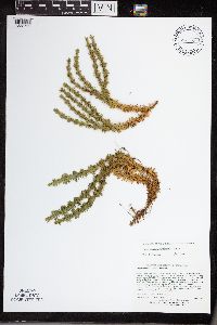 Huperzia lucidula (Michaux) Trevisan 505508[1338792]Lee, Michael MDL3065A2001-07-18 United States, Minnesota, Lake, North Shore. Lake County ... Along County Road 7 and the East Branch Baptism River, three miles northeast of Finland ... T57N R7W S1/2 of SE1/4 of NE1/4 Sec.10. 057N 07W 10, 47.43911 -91.191833 |
MIN:Plants | 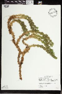 Huperzia lucidula (Michaux) Trevisan 478100[1338867]Gerdes, Lynden 41092000-07-19 United States, Minnesota, Lake, North Shore / Tettegouche State Park. T56N R08W S24SWSW. Lake County ... Tettegouche State Park, northwest of Silver Bay, MN. Long, north-facing (east-west trending) cliff feature approx. 0.31 mile north of Bean Lake.. 056N 08W 24, 47.33958 -91.198054 |
MIN:Plants | 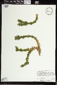 Huperzia lucidula (Michaux) Trevisan 480852[1338865]Lee, Michael MDL24031998-08-25 United States, Minnesota, Morrison, Camp Ripley Military Reservation. Morrison County ... Camp Ripley National Guard Base. Rolling terrain three miles southeast of Pillager ... T133N R30W NE1/4 of NW1/4 Sec. 26. 133N 30W 26, 46.30374 -94.421256 |
MIN:Plants |  Huperzia lucidula (Michaux) Trevisan 915922[1338858]Smith, Welby 313982009-08-27 United States, Minnesota, Cook, Boundary Waters Canoe Area Wilderness / Superior National Forest. Cook County...Boundary Waters Canoe Area Wilderness, Superior National Forest. At the east end of Winchell Lake... T 64N R 2W SE1/4 of SE1/4 of Sec 26. 064N 02W 26, 47.9936111 -90.5369444 |
MIN:Plants | 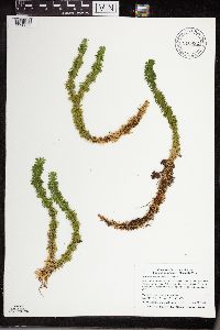 Huperzia lucidula (Michaux) Trevisan 910992[1338859]Smith, Welby 310272008-07-22 United States, Minnesota, Lake, Boundary Waters Canoe Area Wilderness / Superior National Forest. Lake County...Near the southeast end of Fourtown Lake in the Boundary Waters Canoe Area Wilderness, Superior National Forest...T 65N R 11W SE1/4 of SE1/4 of Sec 31. 065N 11W 31, 48.0669444 -91.7822222 |
MIN:Plants |  Huperzia lucidula (Michaux) Trevisan 436044[1338860]Smith, Michael R. 5541997-08-16 United States, Minnesota, Saint Louis, Voyageurs National Park. St. Louis Co.; Plot name: Voya 119 DNR # 7308; Daley Bay;Voyageurs National Park;069N;20W;32, 48.4108315 -92.930275 |
MIN:Plants |  Huperzia lucidula (Michaux) Trevisan 934114[1338868]Smith, Welby R. 33423 United States, Minnesota, Koochiching, About 20 miles N-NE of Waskish. SE of SE of section;Pine Island State Forest;156N;29W;03, 48.3543 -94.3433667 |
MIN:Plants |  Huperzia lucidula (Michaux) Trevisan 910578[1338850]Lee, Michael MDL45732007-10-29 United States, Minnesota, Stearns, Birch Lakes State Forest. Stearns County...Birch Lakes State Forest...just south of the Todd County line, between Big and Little Birch Lakes 1.5 miles southeast of Ward Springs, four miles south-southwest of Grey Eagle...T127N R33W NE1/4 of NW1/4 of NW1/4 Sec. 36...UTM: 5070382N 361265E. 127N 33W 36, 45.766949 -94.777658 |
MIN:Plants |  Huperzia lucidula (Michaux) Trevisan 923792[1338825]Lee, Michael MDL35192003-08-04 United States, Minnesota, Todd, N side of Mound Lake, 2 miles S of Burtrum, 3.5 miles E-NE of Grey Eagle, above E end of Little Mound Lake.;;127N;32W;02, 45.838507 -94.685014 |
MIN:Plants |  Huperzia lucidula (Michaux) Trevisan 934075[1338864]Smith, Welby R. 33489 United States, Minnesota, Koochiching, About 19 miles east of Waskish. SW of SW of section;Pine Island State Forest;154N;27W;22, 48.1372 -94.1009333 |
MIN:Plants |  Huperzia lucidula (Michaux) Trevisan 936602[1338754]Smith, Welby R. 300642007-06-13 United States, Minnesota, Itasca, About 2 miles north-northwest of Swan River (town). SW of SW of section;;053N;22W;06, 47.0998111 -93.1849152 |
MIN:Plants |  Huperzia lucidula (Michaux) Trevisan 937738[1338845]Gerdes, Lynden B. 67112012-08-16 United States, Minnesota, Lake, Disappointment Lake area. Hiking trail approximately 0.37 miles SE of the landing/portage to Ahsub Lake and 0.07 east of lake.;Boundary Waters Canoe Area Wilderness / Superior National Forest;064N;08W;27, 47.994722 -91.345 |
MIN:Plants |  Huperzia lucidula (Michaux) Trevisan 942322[1338761]Gerdes, Lynden B. 69152013-08-15 United States, Minnesota, Saint Louis, Approximately 13.40 miles ENE of Crane Lake, MN and 0.07 miles north of Little Beartrack Lake. NENW of section;Boundary Waters Canoe Area Wilderness / Superior National Forest;67N;15W;12, 48.303506 -92.203127 |
MIN:Plants |  Huperzia lucidula (Michaux) Trevisan 946444[1289975]Gerdes, Lynden B. 61202010-07-19 United States, Minnesota, Cook, Superior National Forest. BWCAW. Paulson Lake; approximately 0.03 miles east of the northern most finger of lake. NWNWSWNE of section; T065N R05W sec24, 48.102778 -90.910278 |
MIN:Plants |  Huperzia lucidula (Michaux) Trevisan 950705[1290007]Perry, Ethan F. 110022011-08-10 United States, Minnesota, Lake, T65N R6W NE1/4 of SW1/4 of Sec 10; About 170m north of South Arm of Knife Lake [Boundary Waters Canoe Area Wilderness / Superior National Forest], 48.12555 -91.090226 |
MIN:Plants |  Huperzia lucidula (Michaux) Trevisan 950728[1290068]Perry, Ethan F. 140232014-08-15 United States, Minnesota, Saint Louis, T57N R16W NW1/4 of NE1/4 of Sec1; 5.3 miles southeast of Gilbert; 1.4 miles west of Lost Lake boat landing, 47.426598 -92.398356 |
MIN:Plants |  Huperzia lucidula (Michaux) Trevisan 948378[1292525]Smith, Welby R. WRS341532012-08-09 United States, Minnesota, Koochiching, Lake Agassiz Peatland National Natural Landmark, about 15 miles (24 km) southeast of Big Falls.; T064N R25W sec05, 48.0639833 -93.5552833 |
MIN:Plants |  Huperzia lucidula (Michaux) Trevisan 948225[1292384]Smith, Welby R. WRS308332007-09-14 United States, Minnesota, Wabasha, Krugar Recreation Area, about 3 miles southwest of Wabasha (town).; T110N R10W sec18, 44.3273806 -92.0530311 |
MIN:Plants |  Huperzia lucidula (Michaux) Trevisan 947891[1292026]Smith, Welby R. 305122007-08-02 United States, Minnesota, Aitkin, Hill River State Forest, about 6 miles east of Hill City. SW of SE of section; T052N R25W sec14, 46.9892306 -93.4724094 |
MIN:Plants |  Huperzia lucidula (Michaux) Trevisan 947967[1291973]Smith, Welby R. 305942007-08-16 United States, Minnesota, Carlton, In Fond Du Lac State forest, about 5 miles northeast of Cromwell. NW of SW of section; T049N R20W sec13, 46.7271603 -92.8260808 |
MIN:Plants |  Huperzia lucidula (Michaux) Trevisan 949797[1297455]Smith, Welby R. 33663 United States, Minnesota, Goodhue |
MIN:Plants |  Huperzia lucidula (Michaux) Trevisan 959049[1305276]Gerdes, Lynden B. 57072008-09-15 United States, Minnesota, Saint Louis, Superior National Forest. Approximately 5.74 miles NNW of Ely, MN and 0.36 miles N of High Lake. Accessed south off of FR 460., 47.985 -91.86222222 |
MIN:Plants |  Huperzia lucidula (Michaux) Trevisan 959064[1305291]Gerdes, Lynden B. 59442009-09-15 United States, Minnesota, Cook, Superior National Forest. Boundary Waters Canoe Area Wilderness. South of the Royal River and 0.32 miles SE of John Lake., 48.06138889 -90.04361111 |
MIN:Plants |  Huperzia lucidula (Michaux) Trevisan 959014[1305241]Gerdes, Lynden B. 60212010-06-16 United States, Minnesota, Cook, Superior National Forest. Approximately 0.74 miles southeast of McFarland Lake and 0.30 miles northeast of Cty. Rd.16., 48.03805556 -90.04555556 |
MIN:Plants |  Huperzia lucidula (Michaux) Trevisan 959020[1305247]Gerdes, Lynden B. 61202010-07-19 United States, Minnesota, Cook, Superior National Forest. BWCAW. Paulson Lake; approximately 0.03 miles east of the northern most finger of lake., 48.10277778 -90.91027778 |
MIN:Plants |  Huperzia lucidula (Michaux) Trevisan 959022[1305249]Gerdes, Lynden B. 63812011-08-16 United States, Minnesota, Lake, Superior National Forest. Approximately 20.73 miles NW of Isabella, MN and 1.56 miles east of Birch Lake. Area of ongoing mining exploration and recent timber sale layout., 47.77916667 -91.7275 |
MIN:Plants |  Huperzia lucidula (Michaux) Trevisan 959006[1305233]Gerdes, Lynden B. 64602011-11-02 United States, Minnesota, Lake, Superior National Forest. Approximately 9.60 miles north of Isabella, MN and 0.35 miles east of the Tomahawk Road (FR377) and Northwest Road (FR 373) intersection., 47.75416667 -91.38416667 |
MIN:Plants |  Huperzia lucidula (Michaux) Trevisan 958957[1305177]Gerdes, Lynden B. 71582014-08-01 United States, Minnesota, Saint Louis, Superior National Forest, Lake Agnes, BWCAW. Large bedrock outcrop complex southeast of lake., 48.20472222 -92.03944444 |
MIN:Plants |  Huperzia lucidula (Michaux) Trevisan 959372[1311203]Gerdes, Lynden B. 72392015-06-17 United States, Minnesota, Koochiching, Koochiching State Forest. Approximately 6.49 miles east of Littlefork, MN and 0.15 miles north of Highway 217., 48.39861111 -93.40861111 |
MIN:Plants |  Huperzia lucidula (Michaux) Trevisan 959900[1318197]Anderson, Chel E. 24372017-07-31 United States, Minnesota, Koochiching, 9.2 mi north of Kelliher on Hwy 72. East 3.1 mi on Beltrami Cty i6. North 3.8 mi on Kooch Cty NFR98, Lt. Tamarac Rd NE. West ~.2 mi into wetland forest complex., 48.13 -94.41 |
MIN:Plants |  Huperzia lucidula (Michaux) Trevisan 959905[1318202]Anderson, Chel E. 24302017-07-20 United States, Minnesota, Koochiching, 4.3 miles NE of Big Falls on Hwy 71. About .6 mi SE into lowland forest and peatland complex., 48.24 -93.74 |
MIN:Plants |  Huperzia lucidula (Michaux) Trevisan 960347[1318828]Sundberg, Marsh 1969-08-18 United States, Wisconsin, Washburn, Tomahawk Scout Reservation |
MIN:Plants |  Huperzia lucidula (Michaux) Trevisan 960346[1318829]Friesner, Ray 90811935-08-20 United States, Maine, Waldo, Megunticook Lake |
MIN:Plants |  Huperzia lucidula (Michaux) Trevisan 960345[1318830] 1905-00-00 United States, Massachusetts |
MIN:Plants |  Huperzia lucidula (Michaux) Trevisan 968006[1368566]T. J. S. Whitfeld 21662019-06-17 United States, Minnesota, Lake, Boundary Waters Canoe Area Wilderness, northeast part of Alice Lake, 47.947108 -91.208844, 472m |
MIN:Plants |  Huperzia lucidula (Michaux) Trevisan 0967526[1368057]T. J. S. Whitfeld 21922019-06-18 United States, Minnesota, Lake, Boundary Waters Canoe Area Wilderness, western area of Insula Lake, 47.923972 -91.300778, 464m |
MIN:Plants |  Huperzia lucidula (Michaux) Trevisan 386897[1338760]Smith, Welby R. 2011-06-27 United States, Minnesota, Pine Island State Forest, about 22 miles W of Big Falls. T154N R28W S7, 48.165556 -94.275 |
MIN:Plants |  Huperzia lucidula (Michaux) Trevisan 55269[1338869]Watson, J.R. s.n.1895-05-05 United States, Michigan, Medina |
MIN:Plants |  Huperzia lucidula (Michaux) Trevisan 55289[1338870] 1897-06-08 United States, North Carolina, at the crest of the Balsam Mountains |
MIN:Plants |  Huperzia lucidula (Michaux) Trevisan 522834[1338871]Cooper, W.S. s.n.1906-04-03 United States, North Carolina, Turnpike |
MIN:Plants |  Huperzia lucidula (Michaux) Trevisan 55274[1338872]Heller, A.A. 1890-08-11 United States, North Carolina, Grandfather Mountains |
MIN:Plants |  Huperzia lucidula (Michaux) Trevisan 565473[1338873]Wherry, Edgar T. s.n.1952-09-12 United States, Pennsylvania, Susquehanna, 2 miles SW of South Montrose, 41.776804 -75.918793 |
MIN:Plants |  Huperzia lucidula (Michaux) Trevisan 411632[1338874]Small, John K. s.n.1891-12-31 United States, Pennsylvania, Lebanon, South Mountain in the vicinity of Penryn |
MIN:Plants |  Huperzia lucidula (Michaux) Trevisan 55275[1338875]Eby, A.F. 1895-00-00 United States, Pennsylvania, Lancaster, Michy, Beartown |
MIN:Plants |  Huperzia lucidula (Michaux) Trevisan 415902[1338876]Gloenke, Stanley L. 1946-07-26 United States, Pennsylvania, Lackawanna, around W slope of West Mt. 2 miles SSW of Chinchilla |
MIN:Plants |  Huperzia lucidula (Michaux) Trevisan 633730[1338877]Maycock, P.F. 1962-07-03 Canada, Ontario, Perth, 1 mile S of Brunner, Ellice Tp., 43.505915 -80.92241 |
Google Map
Google Maps is a web mapping service provided by Google that features a map that users can pan (by dragging the mouse) and zoom (by using the mouse wheel). Collection points are displayed as colored markers that when clicked on, displays the full information for that collection. When multiple species are queried (separated by semi-colons), different colored markers denote each individual species.