University of Minnesota
http://www.umn.edu/
612-625-5000
http://www.umn.edu/
612-625-5000
Minnesota Biodiversity Atlas
Bell Museum
Dataset: MIN-Plants
Taxa: Ruscaceae
Search Criteria: excluding cultivated/captive occurrences
Bell Museum plants | |
 MIN:Plants | Maianthemum stellatum (L.) Link []Timothy J. S. Whitfeld 35652023-06-13 United States, Minnesota, Washington, Crystal Spring Scientific and Natural Area, 0.4 miles northeast of the intersection of Scandia Trail North and Hwy 95, 45.25703 -92.76459, 249m |
MIN:Plants | 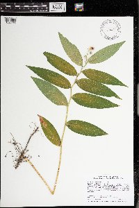 Maianthemum stellatum (L.) Link 974422[1396786]Smith, Welby R WRS364242019-08-07 United States, Minnesota, McLeod, Liable Woods (Nature Conservancy preserve), about 4.8 km (3 miles) east of Biscay at a heading of 80 degrees., 44.834664 -94.215364 |
MIN:Plants | 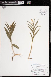 Maianthemum stellatum (L.) Link 977740[1401347]Don Henson 581971-05-28 United States, Michigan, Schoolcraft, SE1/4 NW1/4 Sec 12 T41N R15W, 45.961458 -86.126935 |
MIN:Plants | 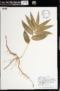 Maianthemum stellatum (L.) Link 977087[1402668]Lee, Michael MDL62682013-06-21 United States, Minnesota, Olmsted, On the east side of U.S. Highway 63, south of County Road 21, eight miles north of downtown Rochester., 44.13429803 -92.41247425, 347m |
MIN:Plants | Maianthemum trifolium (L.) Sloboda 680135[]Coffin, Barbara 3431976-07-11 United States, Wisconsin, Ashland, Presque Isle Point, Stockton Island, Apostle Islands National Lakeshore;Apostle Islands National Lakeshore;;;, 46.916326 -90.548792 |
MIN:Plants | Maianthemum trifolium (L.) Sloboda 473058[]Lee, Michael MDL16761997-06-03 United States, Minnesota, Stearns, Stearns Co.; along the Sauk River 3/4 mile west of Rockville; T123N R29W NE1/4 of NW1/4 Sec. 17, SE1/4 of SE1/4 of SW1/4;;123N;29W;, 45.469043 -94.355202 |
MIN:Plants | Maianthemum trifolium (L.) Sloboda 454522[]US Nat. Arboretum staff s.n.1981-00-00 United States, Minnesota, Crow Wing, Crow Wing Co.;;;;, 46.482372 -94.070879 |
MIN:Plants | Maianthemum trifolium (L.) Sloboda 505461[]Whitfeld, T.J.S. 3502002-06-26 United States, Minnesota, Pope, Pope County ... 7 miles northeast of Glenwood; 3/4 mile north of County Hwy 22 ... T125N R36W NENE 7;;125N;36W;07, 45.7219 -95.28691 |
MIN:Plants | Maianthemum trifolium (L.) Sloboda 461221[]Gerdes, Lynden; et al. 26391998-06-08 United States, Minnesota, Cook, T65N R02W S30SENE. Cook County; Superior National Forest. NEar the NE end of Crab Lake.;Superior National Forest;065N;02W;30, 48.084458 -90.630526 |
MIN:Plants | Maianthemum trifolium (L.) Sloboda 907576[]Lee, Michael MDL42652006-06-27 United States, Minnesota, Otter Tail, Otter Tail County...2.5 miles north-northeast of Hillview, 6.5 miles southwest of Menahga...headwaters of Cat Creek ...T137N R36W NW1/4 of NE1/4 Sec.4 ... UTM: 5175873N 329296E. 137N 36W 4, 46.709692 -95.237474 |
MIN:Plants | Maianthemum trifolium (L.) Sloboda 507969[]Lee, Michael MDL22631998-07-20 United States, Minnesota, Wright, Wright Co. ... Stanley Eddy County Park 3-1/2 miles south-southwest of South Haven ... T120N R28W NW1/4 of NW1/4 Sec. 5;Stanley Eddy County Park;120N;28W;5, 45.232465 -94.226148 |
MIN:Plants | Maianthemum trifolium (L.) Sloboda 226896[]Rosendahl, C.; Butters, F. 45561924-07-02 United States, Minnesota, Cook, Near Pigeon River.;Grand Portage Indian Reservation / North Shore;;;, 48.010163 -89.708422 |
MIN:Plants | Maianthemum trifolium (L.) Sloboda 273238[]Rosendahl, C. 60041929-08-11 United States, Minnesota, Cook, W side of Grand Portage Bay;Grand Portage Indian Reservation / North Shore;063N;06E;, 47.962387 -89.683423 |
MIN:Plants | Maianthemum trifolium (L.) Sloboda 275991[]Grant, Martin 27861929-07-15 United States, Minnesota, Hubbard, Itasca State Park; SE of Mary Lake;Itasca State Park;143N;35W;30, 47.173999 -95.161385 |
MIN:Plants | Maianthemum trifolium (L.) Sloboda 276766[]Huff, N. 471914-07-02 United States, Minnesota, Lake, North Kawishiwi River;Superior National Forest;N;;, 47.900775 -91.387134 |
MIN:Plants | Maianthemum trifolium (L.) Sloboda 282009[]Rosendahl, C. 12331903-05-23 United States, Minnesota, Hennepin, ? mi S of Deephaven Station, Minnetonka Car line.;;N;;, 44.913296 -93.503288 |
MIN:Plants | Maianthemum trifolium (L.) Sloboda 349859[]Nielsen, E. 24781934-05-31 United States, Minnesota, Clearwater, Garrison Point [Lake Itasca], Itasca State Park;Itasca State Park;143N;36W;, 47.197458 -95.201964 |
MIN:Plants | Maianthemum trifolium (L.) Sloboda 352697[]Benner, F.; Benner, J. 6901929-08-22 United States, Minnesota, Cook, Just E of Grand Portage.;Grand Portage Indian Reservation / North Shore;063N;06E;, 47.9667 -89.7667 |
MIN:Plants | Maianthemum trifolium (L.) Sloboda 353311[]Lakela, Olga 24271938-06-05 United States, Minnesota, Saint Louis, About 10 mi E of Brookstone on Hwy no. 2.;;N;;, 46.866505 -92.388261 |
MIN:Plants | Maianthemum trifolium (L.) Sloboda 360313[]Lakela, Olga 36621940-07-05 United States, Minnesota, Cook, Near Windigo Point, Sea Gull Lake.;Boundary Waters Canoe Area Wilderness / Superior National Forest;065N;05W;, 48.149256 -90.887916 |
MIN:Plants | Maianthemum trifolium (L.) Sloboda 362728[]Lakela, Olga 36701940-07-05 United States, Minnesota, Cook, The Major's Place, Sea Gull Lake.;Boundary Waters Canoe Area Wilderness / Superior National Forest;065N;05W;, 46.443433 -94.351228 |
MIN:Plants | Maianthemum trifolium (L.) Sloboda 368220[]Oppedahl, R. s.n.1981-06-19 United States, Minnesota, Saint Louis, Elevation 1460' [This locality ca. 12 mi out of Ely on FR 1036--rd to Cedar Lake];Superior National Forest;064N;12W;36, 47.390946 -92.344904 |
MIN:Plants | Maianthemum trifolium (L.) Sloboda 368766[]Lakela, Olga 45661941-06-24 United States, Minnesota, Saint Louis, Meander Lake, Echo Trail.;Superior National Forest;065N;14W;, 48.116014 -92.14764 |
MIN:Plants | Maianthemum trifolium (L.) Sloboda 369244[]Lakela, Olga 43881941-06-22 United States, Minnesota, Saint Louis, Normanna Road about 14 mi N of Duluth.;;N;;, 46.985947 -92.106579 |
MIN:Plants | Maianthemum trifolium (L.) Sloboda 391192[]Dayton, E. 381944-05-30 United States, Minnesota, Anoka, Cedar Creek Bog;Cedar Creek National History Area;034N;23W;, 45.40217 -93.199397 |
MIN:Plants | Maianthemum trifolium (L.) Sloboda 395253[]Butters, F.; Abbe, E. 9721944-08-09 United States, Minnesota, Cook, About 1 mi E of Grand Portage.;Grand Portage Indian Reservation / North Shore;063N;06E;, 47.966437 -89.677655 |
MIN:Plants | Maianthemum trifolium (L.) Sloboda 395254[]Dahl, A. 641945-06-17 United States, Minnesota, Cook, Near Poplar Lake.;Superior National Forest;064N;02W;, 48.046734 -90.508674 |
MIN:Plants | Maianthemum trifolium (L.) Sloboda 395323[]Butters, F.; Abbe, E. 1301936-06-27 United States, Minnesota, Cook, Portage between Lize Lake and Caribou Lake.;Boundary Waters Canoe Area Wilderness / Superior National Forest;064N;02W;, 48.024057 -90.510933 |
MIN:Plants | Maianthemum trifolium (L.) Sloboda 395324[]Brown, Spencer 401935-00-00 United States, Minnesota, Cook, Grand Portage;Grand Portage Indian Reservation / North Shore;063N;06E;, 47.962387 -89.683423 |
MIN:Plants | Maianthemum trifolium (L.) Sloboda 407829[]Lakela, Olga 82391949-06-09 United States, Minnesota, Saint Louis, Near Duluth Heights, Duluth.;;N;;, 46.7833 -92.1 |
MIN:Plants | Maianthemum trifolium (L.) Sloboda 412901[]Moore, John; Moore, Marjorie 118931939-08-18 United States, Minnesota, Koochiching, 1 mi east of Tilson Bay, Rainy Lake.;;071N;22W;, 48.607149 -93.198812 |
MIN:Plants | Maianthemum trifolium (L.) Sloboda 413689[]Moore, John; Moore, Marjorie 107521939-05-29 United States, Minnesota, Clearwater, Back of Garrison Point, near the W shore of Lake Itasca, Itasca State Park.;Itasca State Park;143N;36W;, 47.197458 -95.201964 |
MIN:Plants | Maianthemum trifolium (L.) Sloboda 416808[]Lakela, Olga 84271949-06-21 United States, Minnesota, Saint Louis, N of Soudan.;;N;;, 47.812966 -92.238149 |
MIN:Plants | Maianthemum trifolium (L.) Sloboda 421053[]Lakela, Olga 10528a1950-06-24 United States, Minnesota, Saint Louis, At the jcn of Hwy 216 and 7, to Hibbing.;;N;;, 47.427155 -92.937689 |
MIN:Plants | Maianthemum trifolium (L.) Sloboda 421065[]Lakela, Olga 106071950-07-01 United States, Minnesota, Saint Louis, Twin Lakes bog, SE of Brookston.;;N;;, 46.86772 -92.603804 |
MIN:Plants | Maianthemum trifolium (L.) Sloboda 421648[]Ahlgren, Clifford 8161950-07-30 United States, Minnesota, Lake, Quetico-Superior Widerness Research Center, Basswood Lake, Ely;Boundary Waters Canoe Area Wilderness / Superior National Forest;064N;10W;09, 48.074893 -91.57512 |
MIN:Plants | Maianthemum trifolium (L.) Sloboda 421649[]Ahlgren, Clifford 8151950-07-20 United States, Minnesota, Lake, Quetico-Superior Wilderness Research Center, Basswood Lake, Ely.;Boundary Waters Canoe Area Wilderness / Superior National Forest;T064N R10W S10, 48.032733 -91.595634 |
MIN:Plants | Maianthemum trifolium (L.) Sloboda 424001[]Emanuel, J. 1281946-09-04 United States, Minnesota, Itasca, County: Itasca. Locality: Nashwauk Township;;057N;22W;00, 47.40917 -93.195 |
MIN:Plants | Maianthemum trifolium (L.) Sloboda 428277[]Dana, R. 920881992-08-06 United States, Minnesota, Kittson, Twin Lakes Wildlife Management Area. Kittson Co.; Twin Lakes Wildlife Mgmt. Area; at base of prominent beach ridge of Glacial Lake Agassiz; T 159N R 45W NW1/ Kittson Co.; Twin Lakes Wildlife Mgmt. Area; at base of prominent beach ridge of Glacial Lake Agassiz; T 159N R 45W NW1/4 of NE1/4 of Sec 8. 159N 45W 8, 48.622724 -96.486548 |
MIN:Plants | Maianthemum trifolium (L.) Sloboda 440108[]Smith, Welby 128341987-06-04 United States, Minnesota, Mille Lacs, Mille Lacs Co. About 6 miles N of Bock, on the W side of CSAH 24; NE 1/4 NE 1/4 Sec. 14, T39N R26W;Rum River State Forest;039N;26W;14, 45.8777771 -93.5411148 |
MIN:Plants | Maianthemum trifolium (L.) Sloboda 442334[]Lakela, Olga 124551951-06-19 United States, Minnesota, Saint Louis, Curtain Falls Resort, Crooked Lake.;Boundary Waters Canoe Area Wilderness / Superior National Forest;066N;12W;, 48.203274 -91.857461 |
MIN:Plants | Maianthemum trifolium (L.) Sloboda 443164[]Lakela, Olga 131191951-07-12 United States, Minnesota, Saint Louis, 4 mi from Kettle Falls towards Rainey Lake.;Voyageurs National Park;070N;18W;, 48.49944 -92.63889 |
MIN:Plants | Maianthemum trifolium (L.) Sloboda 443255[]Lakela, Olga 128811951-06-29 United States, Minnesota, Saint Louis, Crane Lake Road, N of Vermilion River Bridge, NW St. Louis Co.;Kabetogama State Forest;N;;, 48.2833 -92.4667 |
MIN:Plants | Maianthemum trifolium (L.) Sloboda 443869[]Myhre, K. 48781994-06-06 United States, Minnesota, Itasca, Itasca Co.; Located 0.7 mile southeast of Minisogama Lake; T 147N R 29W NE1/4 of SW1/4 of Sec 35;Chippewa National Forest / Leech Lake Indian Reservation;147N;29W;35, 47.505871 -94.3206 |
MIN:Plants | Maianthemum trifolium (L.) Sloboda 444707[]Moore, John; Huff, N. 179281945-07-24 United States, Minnesota, Morrison, 1 mi S of Cushing.;;N;;, 46.12521 -94.576956 |
MIN:Plants | Maianthemum trifolium (L.) Sloboda 445113[]Moore, John; Huff, N. 195691947-06-14 United States, Minnesota, Itasca, 6 mi N of Grand Rapids.;;N;;, 47.324019 -93.530214 |
MIN:Plants | Maianthemum trifolium (L.) Sloboda 445206[]Moore, John; et al. 174881945-06-29 United States, Minnesota, Kanabec, 7 mi SE of Mora;;;;, 45.80523 -93.19067 |
MIN:Plants | Maianthemum trifolium (L.) Sloboda 446533[]Moore, John; Huff, N. 185741946-06-11 United States, Minnesota, Itasca, Chase Point, Scenic State Park.;Scenic State Park;061N;25W;, 47.735173 -93.557477 |
MIN:Plants | Maianthemum trifolium (L.) Sloboda 447117[]Smith, Welby 191401991-07-08 United States, Minnesota, Koochiching, Koochiching County...About 6 miles south of Birchdale...T 159N R 27W NE1/4 of SE1/4 of Sec 34;;159N;27W;34, 48.5475006 -94.082222 |
MIN:Plants | Maianthemum trifolium (L.) Sloboda 453220[]Smith, Welby 130401987-06-18 United States, Minnesota, Pine, Pine County...In the St. Croix River Valley, about 7 miles southeast of Pine City...about 70 feet above the floodplain...SW1/4 NE1/4 section 21, T 38N R 20W. 038N 20W 21, 45.7666667 -92.8475 |
MIN:Plants | Maianthemum trifolium (L.) Sloboda 456934[]Myhre, K. 36141993-05-20 United States, Minnesota, Pine, Pine Co.; located near the entrance to St. Croix State Park; T 41N R 18W NW1/4 of NW1/4 of Sec 27;Saint Croix State Park;041N;18W;27, 46.004857 -92.605603 |
MIN:Plants | Maianthemum trifolium (L.) Sloboda 460276[]Smith, Welby 132351987-06-29 United States, Minnesota, Washington, Washington County...Corries Swamp, large wetland about 8 miles west of Marine on St. Croix...NW1/4 SE1/4 section 26, T 32N R 21W. 032N 21W 26, 45.2161111 -92.9244444 |
MIN:Plants | Maianthemum trifolium (L.) Sloboda 462674[]Lakela, Olga 143711952-06-22 United States, Minnesota, Saint Louis, Namakan Narrows, International Boundary.;Voyageurs National Park;069N;17W;, 48.430739 -92.490154 |
MIN:Plants | Maianthemum trifolium (L.) Sloboda 462980[]Lakela, Olga 148181952-07-10 United States, Minnesota, Saint Louis, Off Rainy Lake, Cranberry Bay area.;Voyageurs National Park;071N;21W;, 48.623498 -93.206383 |
MIN:Plants | Maianthemum trifolium (L.) Sloboda 481092[]Lakela, Olga 161381953-06-28 United States, Minnesota, Saint Louis, Prairie Lake;;050N;21W;28, 46.79124 -92.904888 |
MIN:Plants | Maianthemum trifolium (L.) Sloboda 481532[]Lakela, Olga 160121953-06-08 United States, Minnesota, Saint Louis, On Vermilion Lake near Treasure Island Resort.;;N;;, 47.891581 -92.366824 |
MIN:Plants | Maianthemum trifolium (L.) Sloboda 497344[]Monson, George 3081946-06-23 United States, Minnesota, Saint Louis, French Township;;060N;21W;, 46.942992 -91.949958 |
MIN:Plants | Maianthemum trifolium (L.) Sloboda 506650[]Puchalski, L. 1201992-07-09 United States, Minnesota, Saint Louis, T59N R16W S10 NW1/4; St. Louis Co.;Superior National Forest;059N;16W;10, 47.610427 -92.358318 |
MIN:Plants | Maianthemum trifolium (L.) Sloboda 507430[]Moore, John; et al. 210111951-06-08 United States, Minnesota, Itasca, Itasca County...back of shore of Coon Lake, Scenic Sate Park;Scenic State Park;061N;25W;, 47.723007 -93.563738 |
MIN:Plants | Maianthemum trifolium (L.) Sloboda 508275[]Smith, Welby 187321991-06-07 United States, Minnesota, Todd, Todd Co.; about 3.5 mi SW of Motley; T133N R32W NW1/4 of NE1/4 of Sec 27;;133N;32W;27, 46.3088875 -94.7011108 |
MIN:Plants | Maianthemum trifolium (L.) Sloboda 524457[]Benner, J. s.n.1938-06-19 United States, Minnesota, Cook, Cook County ... E of Echo Lake;Boundary Waters Canoe Area Wilderness / Superior National Forest;063N;02W;, 47.726653 -90.386005 |
MIN:Plants | Maianthemum trifolium (L.) Sloboda 526903[]Lakela, Olga 174371954-06-15 United States, Minnesota, Saint Louis, Pelican Lake at Orr.;Kabetogama State Forest;N;;, 48.07265 -92.934264 |
MIN:Plants | Maianthemum trifolium (L.) Sloboda 527146[]Lakela, Olga 179321954-07-24 United States, Minnesota, Saint Louis, Gun Lake, N of Ely, Superior National Forest.;Boundary Waters Canoe Area Wilderness / Superior National Forest;065N;12W;, 48.114633 -91.831223 |
MIN:Plants | Maianthemum trifolium (L.) Sloboda 533089[]Lakela, Olga 201041956-06-25 United States, Minnesota, Saint Louis, On Hwy #5 about 5 mi S of Greaney;;N;;, 47.894777 -93.021006 |
MIN:Plants | Maianthemum trifolium (L.) Sloboda 560943[]Ownbey, Gerald; Anderson, Henry 27191959-06-24 United States, Minnesota, Clearwater, E side of County Road 103, about 6.8 straight-line mi N-NW of Zerkel.;;145N;37W;5, 47.404523 -95.519704 |
MIN:Plants | Maianthemum trifolium (L.) Sloboda 578604[]Ownbey, Gerald 31101962-06-14 United States, Minnesota, Hubbard, Itasca State Park. Bog "D", ca. .5 mi SE of Mary Lake.;Itasca State Park;143N;35W;30, 47.173999 -95.161385 |
MIN:Plants | Maianthemum trifolium (L.) Sloboda 590222[]Voss, E. 100691961-07-16 United States, Minnesota, Lake, Lake County...Ca. 14 mi W of Finland; near S end of Cloquet Lake. Sect. 9-16, T57N R9W;Superior National Forest;057N;09W;09, 47.437098 -91.48128 |
MIN:Plants | Maianthemum trifolium (L.) Sloboda 594315[]Thorne, Robert 303591962-06-13 United States, Minnesota, Hubbard, Bog D, about ? mi SE of Mary Lake;Itasca State Park;143N;35W;, 47.194443 -95.1103 |
MIN:Plants | Maianthemum trifolium (L.) Sloboda 603633[]Moore, John 269701966-08-03 United States, Minnesota, Isanti, W side of Beckman Lake, Cedar Creek Natural History Area.;Cedar Creek National History Area;034N;23W;, 45.424392 -93.186774 |
MIN:Plants | Maianthemum trifolium (L.) Sloboda 616402[]Moore, John; Moore, Marjorie 3941969-07-31 United States, Minnesota, Crow Wing, [This locality in general vic of Jack Pine Lake];;044N;28W;29, 46.265228 -93.904064 |
MIN:Plants | Maianthemum trifolium (L.) Sloboda 623127[]Moore, John 273791971-06-04 United States, Minnesota, Isanti, West margin of Beckman Lake, near S end of the Lake. Cedar Creek Natural History Area.;Cedar Creek National History Area;034N;23W;, 45.419091 -93.186946 |
MIN:Plants | Maianthemum trifolium (L.) Sloboda 623333[]Rathbun, E.; et al. s.n.1972-05-23 United States, Minnesota, Cass, Cass County...Boy River Bog, 3 mi E of Boy River. T143N R27W Sec.23 N1/2 NE1/4;Chippewa National Forest;143N;27W;23, 47.101979 -94.06127 |
MIN:Plants | Maianthemum trifolium (L.) Sloboda 669861[]Wheeler, Gerald s.n.1974-06-22 United States, Minnesota, Aitkin, Approximately 3 mi S of Hill City; 2 mi E of Hwy 169 on Willow River Road. Willow River Bog.;Hill River State Forest;N;;, 46.957786 -93.559597 |
MIN:Plants | Maianthemum trifolium (L.) Sloboda 686913[]Wheeler, Gerald; Glaser, Paul 13391977-05-15 United States, Minnesota, Itasca, Collection Site No. 11. Approximately 5 mi W of Grand Rapids.;;055N;26W;21, 47.237524 -93.641535 |
MIN:Plants | Maianthemum trifolium (L.) Sloboda 689599[]Anonymous s.n.1924-06-04 United States, Minnesota, Hennepin, Purgatory Swamp.;;N;;, 44.90005 -93.501232 |
MIN:Plants | Maianthemum trifolium (L.) Sloboda 691140[]Sperling, C. 1861976-05-29 United States, Minnesota, Douglas, Douglas Co.; 1 mi NE of Spruce Center. Wildlife Area.;Spruce Creek Wildlife Management Area;130N;36W;, 46.080756 -95.208887 |
MIN:Plants | Maianthemum trifolium (L.) Sloboda 695819[]Clemants, Steven 13481978-06-20 United States, Minnesota, Crow Wing, Near the Mississippi. 1.5 mi E of County road 6 on county road 11.;;136N;26W;26, 46.565318 -93.920601 |
MIN:Plants | Maianthemum trifolium (L.) Sloboda 698145[]Wheeler, Gerald; Glaser, Paul 29451978-06-08 United States, Minnesota, Beltrami, Approximately 11 mi N of the Waskish Airport on Route 72, about 0.1 mi E of the road. Coll. site No. 3.;Red Lake Peatland Scientific Natural Area;156N;30W;19, 48.316018 -94.543054 |
MIN:Plants | Maianthemum trifolium (L.) Sloboda 699062[]Sather, Nancy; et al. 1081976-06-14 United States, Minnesota, Lake, Lake Co. Jcn of USFS 173 and Minn. Hwy. 1.;Superior National Forest;061N;10W;31, 47.726354 -91.650915 |
MIN:Plants | Maianthemum trifolium (L.) Sloboda 699063[]Sather, Nancy; et al. 3761977-06-14 United States, Minnesota, Lake, Lake Co. Sect. 26, T61N R10W;Superior National Forest;061N;10W;26, 47.740548 -91.565635 |
MIN:Plants | Maianthemum trifolium (L.) Sloboda 699064[]Sather, Nancy; et al. 3591977-06-30 United States, Minnesota, Lake, Lake Co, Plot G02, Sec. 34, T62N R11W;Superior National Forest;062N;11W;34, 47.812447 -91.714681 |
MIN:Plants | Maianthemum trifolium (L.) Sloboda 715361[]Farrell, P. 271979-06-19 United States, Minnesota, Beltrami, Lake Bemidji Bog SNA: 1 mi NW of Lake Bemidji.;;147N;33W;24, 47.536135 -94.815118 |
MIN:Plants | Maianthemum trifolium (L.) Sloboda 715362[]Keller, C. 231979-06-08 United States, Minnesota, Beltrami, Lake Bemidji Bog SNA: 1 mi NW of Lake Bemidji.;;147N;33W;24, 47.536135 -94.815118 |
MIN:Plants | Maianthemum trifolium (L.) Sloboda 715623[]Keller, C. 251979-06-17 United States, Minnesota, Beltrami, Pennington Orchid Bog SNA: 1 mi N of Pennington.;Leech Lake Indian Reservation / Pennington Bog Scientific Natural Area;146N;30W;3, 47.494806 -94.474276 |
MIN:Plants | Maianthemum trifolium (L.) Sloboda 724069[]Smith, Welby 21861980-05-24 United States, Minnesota, Saint Louis, On the S side of State Hwy 2, about 5 mi NW of its jcn with County Hwy 73 in Floodwood.;;052N;21W;21, 46.97618 -93.005586 |
MIN:Plants | Maianthemum trifolium (L.) Sloboda 724613[]Smith, Welby 24801980-06-12 United States, Minnesota, Saint Louis, Arlberg Bog. On N side of county road 2, about 13 mi E of its jcn with State hwy 73 in Floodwood.;;051N;18W;4, 46.923275 -92.614082 |
MIN:Plants | Maianthemum trifolium (L.) Sloboda 724723[]Smith, Welby 24451980-06-11 United States, Minnesota, Cass, Cass Co. On N side of State Hwy 2, about 5.5 mi W of Bena. Sec.23 NW1/4 SW1/4, T145N R29W;Chippewa National Forest / Leech Lake Indian Reservation;145N;29W;23, 47.359203 -94.328728 |
MIN:Plants | Maianthemum trifolium (L.) Sloboda 758151[]Smith, Welby 62961982-06-11 United States, Minnesota, Clearwater, On the E side of County Hwy 5, about 2? mi N of its jcn with State Hwy 92 in Clearbrook.;;149N;37W;17, 47.724444 -95.420116 |
MIN:Plants | Maianthemum trifolium (L.) Sloboda 758187[]Smith, Welby 62791982-06-11 United States, Minnesota, Beltrami, On the W side of State Hwy 72, about 3? mi S of Waskish.;;154N;30W;32, 48.119426 -94.510738 |
MIN:Plants | Maianthemum trifolium (L.) Sloboda 758225[]Smith, Welby 70601982-08-05 United States, Minnesota, Itasca, George Washington State Forest. Itasca County...about 5-1/2 mi E-SE of Bigfork. SE1/4 of NW1/4 of sec.4, T 60N R 25W Itasca Co.; about 5? mi E-SE of Bigfork. SE1/4 of NW1/4 of sec.4, T 60N R 25W. 060N 25W 4, 47.713274 -93.523246 |
MIN:Plants | Maianthemum trifolium (L.) Sloboda 762807[]Hart, H. s.n.1922-05-26 United States, Minnesota, Hennepin, Purgatory Swamp;;N;;, 44.90005 -93.501232 |
MIN:Plants | Maianthemum trifolium (L.) Sloboda 773091[]Boe, J. 72B1979-06-07 United States, Minnesota, Lake of the Woods, Near Norris Camp.;;159N;35W;8, 48.605309 -95.181076 |
MIN:Plants | Maianthemum trifolium (L.) Sloboda 773123[]Boe, J. 1061979-06-12 United States, Minnesota, Lake of the Woods, Brown's Lake.;;159N;35W;11, 48.605322 -95.116 |
MIN:Plants | Maianthemum trifolium (L.) Sloboda 773125[]Boe, J. 1041979-06-12 United States, Minnesota, Lake of the Woods, Brown's Lake;;159N;35W;11, 48.605322 -95.116 |
MIN:Plants | Maianthemum trifolium (L.) Sloboda 774396[]Monson, Paul 53991983-06-17 United States, Minnesota, Saint Louis, Namakan Lake, Hoist Bay. Westside.;Voyageurs National Park;069N;19W;34, 48.433517 -92.705646 |
MIN:Plants | Maianthemum trifolium (L.) Sloboda 776308[]Morley, T. s.n.1985-07-21 United States, Minnesota, Rice, Rice Co. Ca. ?mi S of E side of Shields Lake.;;110N;22W;2, 44.362941 -93.433063 |
MIN:Plants | Maianthemum trifolium (L.) Sloboda 776419[]Wheeler, Gerald s.n.1985-07-23 United States, Minnesota, Itasca, Marcell Bog. Approximately 18 mi N of Grand Rapids on Route 49; between Cutaway Lake and Spring Lake.;Chippewa National Forest;058N;25W;13, 47.507443 -93.459706 |
MIN:Plants | Maianthemum trifolium (L.) Sloboda 780382[]Ownbey, Gerald 70381985-07-18 United States, Minnesota, Aitkin, Aitkin Co. Just NE of Dam Lake, un-named bog lake. Elev. 1225 ft.;;047N;25W;36, 46.517789 -93.439204 |
MIN:Plants | Maianthemum trifolium (L.) Sloboda 781080[]Smith, Welby 90711984-06-12 United States, Minnesota, Koochiching, Koochiching co.; About 23 mi N of Northome; T 155N R 29W Sec. 35;Lost River Peatland Scientific Natural Area;155N;29W;35, 48.152178 -94.339892 |
MIN:Plants | Maianthemum trifolium (L.) Sloboda 781614[]Smith, Welby 92211984-06-15 United States, Minnesota, Koochiching, Koochiching Co.; Nett Lake Peatland, about 1 mi south of Nett Lake; T 65N R 22W Sec. 33;Nett Lake Indian Reservation / Nett Lake Peatland Scientific Natural Area;065N;22W;33, 48.075085 -93.172301 |
Google Map
Google Maps is a web mapping service provided by Google that features a map that users can pan (by dragging the mouse) and zoom (by using the mouse wheel). Collection points are displayed as colored markers that when clicked on, displays the full information for that collection. When multiple species are queried (separated by semi-colons), different colored markers denote each individual species.