University of Minnesota
http://www.umn.edu/
612-625-5000
http://www.umn.edu/
612-625-5000
Minnesota Biodiversity Atlas
Bell Museum
Dataset: MIN-Plants
Taxa: Lycopodiaceae
Search Criteria: excluding cultivated/captive occurrences
Bell Museum plants | |
 MIN:Plants |  Huperzia lucidula (Michaux) Trevisan 975836[1404887]Dunevitz, Hannah L. 9541993-07-28 United States, Minnesota, Winona, North-facing bluff above Hemingway Creek., 43.85965 -91.896715 |
MIN:Plants |  Huperzia lucidula (Michaux) Trevisan 975936[1373489]Smith, Welby R WRS366072020-03-27 United States, Minnesota, Anoka, Carlos Avery State Wildlife Management Area; 8.75 km (5.4 miles) due west from the junction of Interstate 35 and State 22 in the town of Wyoming., 45.3365833 -93.1162833 |
MIN:Plants |  Huperzia lucidula (Michaux) Trevisan 975929[1373482]Smith, Welby R WRS366342020-04-27 United States, Minnesota, Pine, Along the south side of the Snake River, about 0.75 km (0.5 mile) southwest of its confluence with the St. Croix River., 45.82111 -92.77335 |
MIN:Plants |  Huperzia lucidula (Michaux) Trevisan 976036[1373589]Smith, Welby R WRS367032020-06-18 United States, Minnesota, Lake Of The Woods, Red Lake State Wildlife Management Area. On the Faunce-Butterfield Forest Road 34 km (21 miles) S-SE of Warroad at a heading of 163 degrees., 48.61327 -95.1771 |
MIN:Plants |  Huperzia lucidula (Michaux) Trevisan 976189[1373741]Smith, Welby R WRS369342020-08-27 United States, Minnesota, Pine, At the southwest corner of Dago Lake; about 3.7 km (2.3 miles) southeast of the town of Sturgeon Lake., 46.3533 -92.79713 |
MIN:Plants |  Huperzia lucidula (Michaux) Trevisan 976395[1403113]Dunevitz, Hannah L. 4691991-07-09 United States, Minnesota, Winona, in the Whitewater Wildlife Management Area. About 0.3 miles east of the Whitewater River and 2 miles north of County Road 26, 44.12 -91.99 |
MIN:Plants |  Huperzia lucidula (Michaux) Trevisan 977585[1401172]Anderson, Derek S. 34122020-09-30 United States, Minnesota, Chisago, Wild River State Park. About 5.2 km east-northeast of Almelund. About 750 m east of the intersection of Wild Mountain Rd. and Sandberg Rd., 45.49935 -92.71963 |
MIN:Plants |  Huperzia lucidula (Michaux) Trevisan 977615[1401203]Anderson, Derek S. 34492020-11-02 United States, Minnesota, Isanti, Twin Lakes SNA. About 8 km northwest of Stacy. About 300 m northeast of the intersection of Muhlenberg St. and Cty. Rd. 9 (267th Ave. NE)., 45.45276 -93.04996 |
MIN:Plants |  Huperzia lucidula (Michaux) Trevisan 977633[1401221]Anderson, Derek S. 37522021-10-05 United States, Minnesota, Aitkin, Solana State Forest. About 5.3 km northeast of Dads Corner (intersection of State Hwy. 65 and Cty. Rd. 2). Approximately 500 m west of the end of East White Pine Forest Road., 46.36459 -93.20988 |
MIN:Plants |  Huperzia lucidula (Michaux) Trevisan 977647[1401235]Anderson, Derek S. 37852021-10-29 United States, Minnesota, Carlton, Fond du Lac State Forest. About 8.7 km southeast of Cromwell. About 4 km south of the intersection of State Hwy 210 and Kettle Lake Rd. At the end of Kettle Lake Rd., 46.64257 -92.78381 |
MIN:Plants |  Huperzia lucidula (Michaux) Trevisan 977654[1401242]Anderson, Derek S. 37732021-10-29 United States, Minnesota, Carlton, Carlton County Forest. About 16 km southwest of Cromwell. On Sauvolz Rd, about 1.7 km west of the intersection with Erickson Rd., 46.57861 -93.03365 |
MIN:Plants |  Huperzia lucidula (Michaux) Trevisan 977559[1401146]Anderson, Derek S. 34302020-10-08 United States, Minnesota, Chisago, Carlos Avery WMA. About 4 km east-northeast of Stacy. About 570 m southwest of the Cty. Rd. 19 bridge over the Sunrise River., 45.40398 -92.93521 |
MIN:Plants |  Huperzia lucidula (Michaux) Trevisan 977621[1401209]Anderson, Derek S. 34392020-10-15 United States, Minnesota, Chisago, Carlos Avery WMA. About 3.6 km northeast of Stacy. About 780 meters northeast of the intersection of Hemmingway Ave. and 320th St., 45.41713 -92.95325 |
MIN:Plants |  Huperzia lucidula (Michaux) Trevisan 977739[1401346]Don Henson 21971-04-28 United States, Michigan, Schoolcraft, SE slope. N½ SE ¼ sec 23 T42N-R16W |
MIN:Plants |  Huperzia lucidula (Michaux) Trevisan 977155[1402736]Lee, Michael MDL62212013-06-11 United States, Minnesota, Pine, Banning State Park. Along the Kettle River just north of the Highway 123 bridge at Sandstone., 46.13041652 -92.85532721, 299m |
MIN:Plants |  Huperzia lucidula (Michaux) Trevisan 977339[1402923]Lee, Michael MDL67102014-08-28 United States, Minnesota, Lake, Boundary Waters Canoe Area Wilderness. Strongly rolling bedrock terrain 13 miles north-northeast of Ely, on a fairly large peninsula in the northeast end of Fourtown Lake., 48.09439833875 -91.78350045801, 116m |
MIN:Plants |  Huperzia lucidula (Michaux) Trevisan 977295[1402879]Lee, Michael MDL66712014-08-08 United States, Minnesota, Koochiching, On the margin of an extensive peatland complex just east of the South Fork of the Black River, 20 miles northwest of Big Falls., 48.4128375334 -94.09669358927, 49m |
MIN:Plants |  Huperzia lucidula (Michaux) Trevisan 977357[1402941]Lee, Michael MDL67402014-09-18 United States, Minnesota, Fillmore, Rugged forested terrain along the Root River two miles southwest of Rushford, on the south side of the river two miles east of Peterson., 43.79222330555 -91.7843930316, 21m |
MIN:Plants |  Diphasiastrum complanatum (L.) Holub 283099[1322822]Butters, F.K. 4541932-07-16 United States, Minnesota, Cook, Hillside north of Clearwater Lake, Cook Co. T.65N, R.1E.;Boundary Waters Canoe Area Wilderness / Superior National Forest;065N;01E;, 48.091577 -90.31984 |
MIN:Plants |  Diphasiastrum complanatum (L.) Holub 55235[1322819]Lyon, H. 8641904-07-14 United States, Minnesota, Saint Louis, Tower;;062N;15W;, 47.805475 -92.274605 |
MIN:Plants | 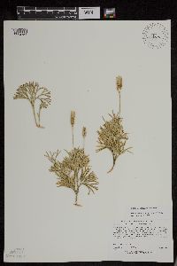 432503[1294754]Lee, Michael D. MDL26631999-08-04 United States, Minnesota, Lake, Ten miles northeast of Toimi. 1-1/2 miles east of Greenwood Lake. T58N R10W SE1/4 of SW1/4 Sec. 10 [Superior National Forest], 47.518697 -91.60039 |
MIN:Plants | 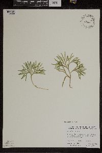 Diphasiastrum complanatum (L.) Holub 484808[1305808]Anderson, Craig 11682000-09-06 United States, Minnesota, Benton, Benton Co.; T38N R31W: 1/4 of NW1/4 of NE1/4 of Sect. 4;;038N;31W;4, 45.723225 -94.003473 |
MIN:Plants | 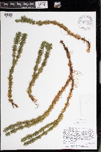 Huperzia lucidula (Michaux) Trevisan 977335[1402919]Lee, Michael MDL67542014-09-24 United States, Minnesota, St. Louis, Strongly rolling forested terrain west of Ash Lake, eight miles north-northeast of the town of Nett Lake, 14 miles northwest of Orr., 48.19674900367 -93.05689569165, 110m |
MIN:Plants | 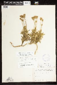 Diphasiastrum complanatum (L.) Holub 387769[1322815]Schuster, R. s.n.1947-08-00 United States, Minnesota, Lake of the Woods, Lake of the Woods Co.; Angle Inlet;Northwest Angle;168N;33W;, 49.341053 -94.913828 |
MIN:Plants |  Diphasiastrum complanatum (L.) Holub 55451[1327098]Wheeler, William 6701900-08-00 United States, Michigan, Keweenaw, Tobin's Harbor, Isle Royal.;Isle Royale National Park |
MIN:Plants |  Diphasiastrum complanatum (L.) Holub 583406[1322786]Kellner, H. 1951956-07-05 United States, Minnesota, Lake, Lake Co. ... between Highway 61 and L. Superior, Encampment Forest;North Shore;053N;10W;00, 47.073479 -91.606077 |
MIN:Plants |  Diphasiastrum complanatum (L.) Holub 477739[1305807]Gerdes, Lynden 42302000-08-11 United States, Minnesota, Lake, North Shore / Tettegouche State Park. Lake County ... Tettegouche State Park. Approximately .25 mile NW of Illgen City, Mn; and just SW up & off Hwy 1 ... T56N R07W S11NESW. 056N 07W 11, 47.33958 -91.198054 |
MIN:Plants |  Diphasiastrum complanatum (L.) Holub 357398[1322825]Rosendahl, C. 6035C1929-08-13 United States, Minnesota, Cook, Cook Co.; in bay at east end of Susie Island;North Shore / Susie Islands, The Nature Conservancy;064N;07E;, 47.973776 -89.578978 |
MIN:Plants |  Diphasiastrum complanatum (L.) Holub 297731[1327097]Mexia, Ynes 22531928-08-16 United States, Alaska, McKinley National Park ... Near center of N. Boundary of Park...Hill crest W. of Wonder Lake.;Denali National Park;;;, 63.45884 -150.86412, 700m |
MIN:Plants |  Diphasiastrum complanatum (L.) Holub 407276[1322818]Lakela, Olga 86021949-06-26 United States, Minnesota, Saint Louis, near Ely, Highway #1. St. Louis Co.;Superior National Forest;063N;12W;, 47.9 -91.8667 |
MIN:Plants |  Diphasiastrum complanatum (L.) Holub 479299[1322796]Swanson, Gary 10641998-07-08 United States, Minnesota, Sherburne, Sherburne National Wildlife Refuge; SENW 26-35-27, FQURU 13;Sherburne National Wildlife Refuge;T035N R27W S26, 45.494002 -93.664739 |
MIN:Plants |  Diphasiastrum complanatum (L.) Holub 441264[1305804]Dahle, Rolf M. 200362000-09-06 United States, Minnesota, Itasca, Itasca County...In a taconite tailings area about 1.4 miles northwest of the town of Taconite...T 56 R 24 NE1/4 of NE1/4 of Sec 20. 056N 24W 20, 47.3244438 -93.4058304 |
MIN:Plants |  Diphasiastrum complanatum (L.) Holub 358130[1322809]Butters, F.K. s.n.1934-08-25 United States, Minnesota, Cook, Poplar Lake, Cook County;Superior National Forest;064N;02W;, 48.046734 -90.508674 |
MIN:Plants |  Diphasiastrum complanatum (L.) Holub 55237[1322820]Roberts, Thomas s.n.1878-07-00 United States, Ohio, Put-in Bay;;;;, 41.65 -82.8167 |
MIN:Plants |  Diphasiastrum complanatum (L.) Holub 913957[1322797]Perry, Ethan 080372008-07-21 United States, Minnesota, Itasca, Itasca County...0.75 miles E of Wolf Lake...Day Brook...T59N R23W SW1/4 of SE1/4 Sec27;George Washington State Forest;059N;23W;27, 47.5625 -93.2411111 |
MIN:Plants |  Diphasiastrum complanatum (L.) Holub 277181[1322828]Rosendahl, C. 58601929-07-03 United States, Minnesota, Hubbard, La Salle Springs region. Itasca Park.;Itasca State Park;143N;35W;, 47.19592 -95.107697 |
MIN:Plants | Diphasiastrum complanatum (L.) Holub 346054[]Clausen, Robert; et al. 30441937-09-16 Canada, Quebec, Quebec. Saguenay County ... Pointe-aux-Alouettes. |
MIN:Plants |  Diphasiastrum complanatum (L.) Holub 560738[1322790]Ownbey, Gerald 22601955-07-11 United States, Minnesota, Becker, Becker County...2.9 miles east of Juggler Lake (8 miles east of Elbow Lake Ranger Station), State Hwy. 113.;White Earth Indian Reservation / White Earth State Forest;142N;37W;, 47.021937 -95.359584 |
MIN:Plants |  Diphasiastrum complanatum (L.) Holub 488110[1305809]Zager, S. 1998# 3291998-09-03 United States, Minnesota, Crow Wing, Crow Wing County...on inside bend of large meander of Mississippi...T47N R28 W - 1/4 of - 1/4 of SE1/4 of Section 18. NAD27...Releve 7781 MCBS Site CW23. 047N 28W 18, 46.5511093 -93.9202805 |
MIN:Plants |  Diphasiastrum complanatum (L.) Holub 55220[1327010]Sandberg, John s.n.1887-07-00 United States, Idaho, Kootenai, Kootenai Co. |
MIN:Plants |  Diphasiastrum complanatum (L.) Holub 387767[1322824]Lakela, Olga 61991945-09-06 United States, Minnesota, Lake, Mt. Mary. Lake Co.;;;;, 47.523171 -91.408849 |
MIN:Plants |  Diphasiastrum complanatum (L.) Holub 55225[1327008]Sandberg, John s.n.1887-07-00 United States, Idaho, Kootenai, Kootenai Co. |
MIN:Plants | 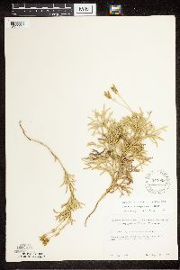 Diphasiastrum complanatum (L.) Holub 543068[1322791]Lakela, Olga 224651957-09-13 United States, Minnesota, Lake, Lake County...Snow Bank Lake, near the Lodge;Superior National Forest;064N;09W;32, 47.98294 -91.462295 |
MIN:Plants | 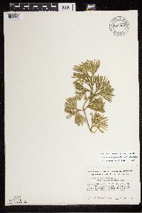 Diphasiastrum complanatum (L.) Holub 679030[1322869]Engels, A. s.n.1975-05-31 United States, Minnesota, Winona, Winona Co. Queen's (Gwynn's ) Bluff, 12 mi SE of Winona, U.S. Rt.61. Scout camp, W side of bluff; W of scout camp.;Great River Bluffs State Park;106N;05W;, 44.044407 -91.640148 |
MIN:Plants | 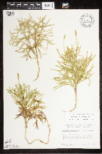 Diphasiastrum complanatum (L.) Holub 684847[1322789]Meyer, Robert J. 151977-08-06 United States, Minnesota, Cook, Cook Co.; Mouth of the Pigeon River; cliff over looking the Pigeon River mouth; W1/2 sec.28 T 64N R 7E;Grand Portage Indian Reservation / North Shore;064N;07E;28, 47.99621 -89.560584 |
MIN:Plants | 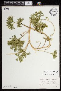 Diphasiastrum complanatum (L.) Holub 694789[1322870]Wagner, W. 732791973-08-15 United States, Minnesota, Saint Louis, St. Louis Co.: Ash River Lookout Area; just S of and across river from Marina in Tourist Resort, T68N, R19W, sec.2;Kabetogama State Forest;068N;19W;2, 48.41713 -92.789044 |
MIN:Plants |  Diphasiastrum complanatum (L.) Holub 699137[1305806]Sather, Nancy 2191976-07-11 United States, Minnesota, Saint Louis, St. Louis Co. Plot 3; NW1/4, SE1/4, S23, T60N, R12W;Superior National Forest; T060N R12W S23, 47.665614 -91.827481 |
MIN:Plants |  Diphasiastrum complanatum (L.) Holub 724687[1305805]Smith, Welby 27321980-07-09 United States, Minnesota, Saint Louis, St. Louis Co. T51N R18W, NE1/4 SE1/4 NW1/4 sec.6. On the N side of Co.Rd.8, and about 11 1/2 mi E of Floodwood;;051N;18W;6, 46.92911 -92.919648 |
MIN:Plants |  Diphasiastrum complanatum (L.) Holub 766346[1322785]Gilbert, H. 201923-05-07 United States, Minnesota, Saint Louis, Duluth;;N;;, 46.7833 -92.1 |
MIN:Plants |  Diphasiastrum complanatum (L.) Holub 773901[1322788]Boe, J. 7891979-07-15 United States, Minnesota, Lake of the Woods, Lake of the Woods Co. Angle Inlet; N1/2 Sec.31 R34W T168N;Northwest Angle;168N;34W;31, 49.346587 -95.047469 |
MIN:Plants |  Diphasiastrum complanatum (L.) Holub 777624[1322787]Coffin, B. 82-1031982-06-17 United States, Minnesota, Cook, Cook Co. T63N, R5E, SW, SW, Sec.25. Red Rock Bay; along Lake Superior.;Grand Portage Indian Reservation / North Shore;063N;05E;25, 47.914337 -89.751755 |
MIN:Plants |  Diphasiastrum complanatum (L.) Holub 821144[1322781]Vixie, D. 4521979-07-26 United States, Minnesota, Saint Louis, St. Louis County ... Moss Lake (formerly Mud Lake), Ely. Morse Twp. T62N R12W S4 SE1/4.;Superior National Forest;062N;12W;4, 47.882157 -91.873168, 442m |
MIN:Plants |  Diphasiastrum complanatum (L.) Holub 910983[1322780]Smith, Welby 291112000-09-08 United States, Minnesota, Cook, Cook County...About 7.5 miles north of Tofte on Co Rd 2 (Sawbill Trail)...T 60N R 4W SE1/4 of SE1/4 of Sec 17;Superior National Forest;060N;04W;17, 47.6747222 -90.8591667 |
MIN:Plants |  Diphasiastrum complanatum (L.) Holub 910599[1322783]Perry, Ethan 20070052007-06-27 United States, Minnesota, Itasca, Itasca County...2.4 miles SW of Dora Lake...T149N R27W NESE23;Chippewa National Forest;149N;27W;23, 47.7069444 -94.0588889 |
MIN:Plants | 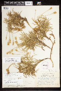 Diphasiastrum complanatum (L.) Holub 275808[1322792]Grant, Martin 31181929-08-18 United States, Minnesota, Clearwater, Itsca Park; Clearwater Co, Headwaters. Sec. NW-NE 3 T. 143 R. 36;Itasca State Park;143N;36W;3, 47.231564 -95.223164 |
MIN:Plants | 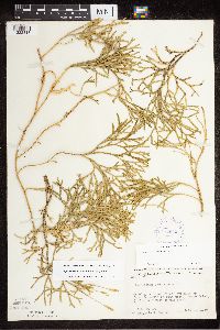 Diphasiastrum complanatum (L.) Holub 412573[1322813]Moore, John s.n.1947-08-00 United States, Minnesota, Lake of the Woods, Lake of the Woods Co.; one mile up from the mouth of Pine Creek, Angle Inlet, 3/4 of a mile west of the creek.;Northwest Angle;168N;34W;, 49.346587 -95.047469 |
MIN:Plants | 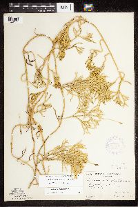 Diphasiastrum complanatum (L.) Holub 357400[1322823]Butters, F.K. 120A1936-06-24 United States, Minnesota, Cook, Cook Co.; Watab Lake. Twp. 65N R. 1E;Boundary Waters Canoe Area Wilderness / Superior National Forest;065N;01E;, 47.726653 -90.386005 |
MIN:Plants | 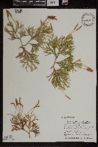 Diphasiastrum complanatum (L.) Holub 505925[1305803]Dahle, Rolf M. 010382001-09-19 United States, Minnesota, Saint Louis, St. Louis County ... In a taconite tailings basin about 2.5 miles west of Hibbing ... T 57 R 21 SW1/4 of SE1/4 of Sec 15. 057N 21W 15, 47.4177778 -92.9919444 |
MIN:Plants |  Diphasiastrum complanatum (L.) Holub 282825[1322821]Butters, F.K. 4561932-07-16 United States, Minnesota, Cook, cliff S. of Clearwater Lake, Cook Co. T.65N, R.1E.;Boundary Waters Canoe Area Wilderness / Superior National Forest;065N;01E;, 48.087449 -90.322587 |
MIN:Plants | Diphasiastrum complanatum (L.) Holub 552398[]Lyon, H.; et al. 471902-05-00 United States, Minnesota, Clearwater, Lake Itasca;Itasca State Park;143N;36W;00, 47.19557 -95.23322 |
MIN:Plants |  Diphasiastrum complanatum (L.) Holub 916993[1322784]Smith, Welby 314822009-09-12 United States, Minnesota, Cook, Boundary Waters Canoe Area Wilderness / Superior National Forest. Cook County...Boundary Waters Canoe Area Wilderness, Superior National Forest. At the south end of John Lake T 65N R 3E SW1/4 of SW1/4 of Sec 34. 065N 03E 34, 48.0672222 -90.0536111 |
MIN:Plants |  Diphasiastrum complanatum (L.) Holub 919259[1322799]Perry, Ethan 090112009-07-15 United States, Minnesota, Cass, Cass County...5.3 miles NE of Bena...T145N R27W NW1/4 of SE1/4 of Sec 16;Chippewa National Forest / Leech Lake Indian Reservation;145N;27W;16, 47.375 -94.1047222 |
MIN:Plants |  Diphasiastrum complanatum (L.) Holub 674228[1327011]Fuller, Todd s.n.1974-06-00 United States, Alaska, Kenai Penninsula. Kenai National Moose Range ... Chickaloon Flats: Approx. 44 miles northeast of Kenai.;;;;, 59.888577 -150.829216 |
MIN:Plants |  Diphasiastrum complanatum (L.) Holub 431777[1305802]Dahle, Rolf M. 020232002-08-08 United States, Minnesota, Itasca, Itasca County ... About 2 miles northwest of Coleraine ... T56N R25W SW1/4 of SW1/4 of Sec 25;;056N;25W;25, 47.3008347 -93.4619446 |
MIN:Plants |  Diphasiastrum complanatum (L.) Holub 407162[1322817]Lakela, Olga 97551949-09-12 United States, Minnesota, Saint Louis, on Ely-Finland Trail near White Iron Lake, St. Louis Co.;Superior National Forest;063N;12W;, 47.9 -91.8667 |
MIN:Plants |  Diphasiastrum complanatum (L.) Holub 419286[1322826]Briggs, John De Q. 1191945-08-03 United States, Minnesota, Cook, Cook Co.; Sawbill Lake. Twp. 62N, R. 4W;Boundary Waters Canoe Area Wilderness / Superior National Forest;062N;04W;, 47.88583 -90.87778 |
MIN:Plants |  Diphasiastrum complanatum (L.) Holub 460051[1322963]Lakela, Olga 171431953-09-05 United States, Minnesota, Saint Louis, St. Louis County ... Trout Lake, northside n. of Vermilion Lake;Boundary Waters Canoe Area Wilderness / Superior National Forest;064N;15W;, 48.4833 -92.8 |
MIN:Plants |  Diphasiastrum complanatum (L.) Holub 357446[1322810]Butters, F.K. 161938-07-05 United States, Minnesota, Cook, South side of Watab Lake.;Boundary Waters Canoe Area Wilderness / Superior National Forest;065N;01E;, 48.0833 -90.35 |
MIN:Plants |  Diphasiastrum complanatum (L.) Holub 358804[1322943]Bergman, H. 30501914-08-14 United States, Minnesota, Hubbard, Benedict;;143N;32W;35, 47.15737 -94.695189 |
MIN:Plants |  Diphasiastrum complanatum (L.) Holub 387766[1322812]Dahl, A. 571945-06-17 United States, Minnesota, Cook, Cook Co.; above Birch Lake (south east portion). Twp. 65N R. 1W 31;Boundary Waters Canoe Area Wilderness / Superior National Forest;065N;01W;31, 47.726653 -90.386005 |
MIN:Plants |  Diphasiastrum complanatum (L.) Holub 907709[1322794]Smith, Welby 309402008-06-18 United States, Minnesota, Cook, Boundary Waters Canoe Area Wilderness / Superior National Forest. Cook County ... Eagle Mountain in the Boundary Waters Canoe Area Wilderness, Superior National Forest ... T63N R2W NW1/4 of SE1/4 of Sec 34. 063N 02W 34, 47.895 -90.56 |
MIN:Plants |  Diphasiastrum complanatum (L.) Holub 527082[1322814]Lakela, Olga 180051954-07-24 United States, Minnesota, Saint Louis, St. Louis Co.; Gun Lake, north of Ely;Boundary Waters Canoe Area Wilderness / Superior National Forest;065N;12W;, 48.114633 -91.831223 |
MIN:Plants |  Diphasiastrum complanatum (L.) Holub 277412[1322827]Rosendahl, C. 59531929-07-28 United States, Minnesota, Hubbard, Along road between two clearings south of La Salle Springs. Itasca Park.;Itasca State Park;143N;35W;, 47.195825 -95.110297 |
MIN:Plants |  Diphasiastrum complanatum (L.) Holub 461280[1322795]Gerdes, Lynden 20281998-07-03 United States, Minnesota, Cook, T65N R02E S21SWSE. Cook Co.; Superior National Forest, BWCAW. Tri-Mountain area, north of West Pike Lake.;Boundary Waters Canoe Area Wilderness / Superior National Forest;065N;02E;21, 48.099994 -90.199525 |
MIN:Plants |  Diphasiastrum complanatum (L.) Holub 907710[1322782]Smith, Welby 310582008-08-04 United States, Minnesota, Saint Louis, Boundary Waters Canoe Area Wilderness / Superior National Forest. St. Louis County...Along the portage between Burntside Lake and Crab Lake, in the Boundary Waters Canoe Area Wilderness, Superior National Forest...T 63N R 14W NE1/4 of SE1/4 of Sec 18. 063N 14W 18, 47.9355556 -92.1633333 |
MIN:Plants | 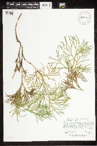 Diphasiastrum complanatum (L.) Holub 905732[1322798]Lee, Michael MDL40702005-08-10 United States, Minnesota, Becker, Becker County...moraine west of Little Dinner Lake, 2 mi north of Two Inlets...slope rising out of...swamp complex ...T142N R36W N1/2ofNE1/4ofNW1/4 Sec. 35; S1/2ofSE1/4ofSW1/4 Sec. 26. 142N 36W 0, 47.079806 -95.205151 |
MIN:Plants | 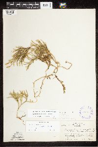 Diphasiastrum complanatum (L.) Holub 289036[1322811]Rosendahl, C.O. 62521930-08-19 United States, Minnesota, Cook, Island at Clark's Bay; Grand Portage;Grand Portage Indian Reservation / North Shore;064N;07E;, 47.95 -89.6833 |
MIN:Plants | 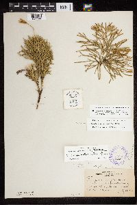 Diphasiastrum complanatum (L.) Holub 350638[1322944]Nielsen, E. 661930-07-23 United States, Minnesota, Cass, Norway Beach, Cass Lake;Chippewa National Forest / Leech Lake Indian Reservation;145N;30W;, 47.419288 -94.536519 |
MIN:Plants | 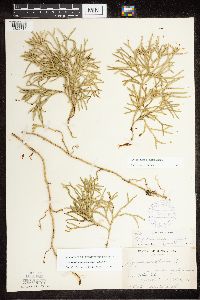 Diphasiastrum complanatum (L.) Holub 387768[1322816]Dahl, A. 50D1945-06-16 United States, Minnesota, Cook, Cook Co.; near Poplar Lake;Superior National Forest;064N;02W;, 48.046734 -90.508674 |
MIN:Plants |  Diphasiastrum complanatum (L.) Holub 926557[1322805]Morantes, Andres F. AFM2012009-08-05 United States, Minnesota, Saint Louis, UTM: E567,313 N5,256,479. NW of section.;Superior National Forest;T57N R14W S03, 47.452453 -92.102913 |
MIN:Plants |  929069[1294753]Anderson, Chel 21662011-06-25 United States, Minnesota, Lake, Near Polly Lake. UTM: 5306189 / 642440. NESE of section [Boundary Waters Canoe Area Wilderness / Superior National Forest], 47.8932011 -91.0943958 |
MIN:Plants |  Diphasiastrum complanatum (L.) Holub 928657[1322829]Smith, Welby 161041989-08-13 United States, Minnesota, Cook, SE end of Ranger Lake. NW1/4 of SE1/4 of section;Boundary Waters Canoe Area Wilderness / Superior National Forest;063N;04W;03, 47.969101 -90.817411 |
MIN:Plants |  Diphasiastrum complanatum (L.) Holub 930602[1322808]Gerdes, Lynden B. 61662010-08-05 United States, Minnesota, Lake, Approximately 0.15 miles west of the far northwestern portion of Ester Lake and 0.06 miles east of the northern tip of an unnamed lake. SENENESE of section;Superior National Forest;066N;06W;27, 48.1713889 -91.0758333 |
MIN:Plants |  Diphasiastrum complanatum (L.) Holub 931474[1322800]Gerdes, Lynden B. 64652011-11-02 United States, Minnesota, Lake, Superior National Forest. Approximately 8.62 miles north of Isabella, MN and 0.20 miles east of the Tomahawk Road (FR377) and FR 373BA intersection. NWNWSENE. 061N 08W 30, 47.7391667 -91.3897222 |
MIN:Plants |  Diphasiastrum complanatum (L.) Holub 931507[1322801]Gerdes, Lynden B. 63792011-08-16 United States, Minnesota, Lake, Superior National Forest. Approximately 20.74 miles NW of Isabella, MN and 1.54 miles east of Birch Lake. Area of ongoing mining exploration and recent timber sale layout. NESESESE. 061N 11W 9, 47.7786111 -91.7277778 |
MIN:Plants |  Diphasiastrum complanatum (L.) Holub 931783[1322802]Smith, Welby R. 204231992-06-16 United States, Minnesota, Cass, About one mile south of Lake Thirteen; NW of SW of section;Chippewa National Forest;144N;31W;24, 47.2694444 -94.5519444 |
MIN:Plants |  Diphasiastrum complanatum (L.) Holub 935344[1322803]Smith, Welby R. 333422011-08-12 United States, Minnesota, Lake, Superior National Forest, Boundary Waters Canoe Area Wildnerness. Along the south side of Lake Isabella. SE of SE of section;Boundary Waters Canoe Area Wilderness / Superior National Forest;062N;08W;36, 47.8034667 -91.2772833 |
MIN:Plants | 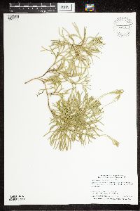 Diphasiastrum complanatum (L.) Holub 306772[1322807]Smith, Welby R. 317652010-06-24 United States, Minnesota, Cook, Near the east end of Ross Lake. SE of NW of section;Boundary Waters Canoe Area Wilderness / Superior National Forest;064N;03W;16, 48.0288826 -90.7134111 |
MIN:Plants | 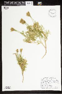 Diphasiastrum complanatum (L.) Holub 98539[1322804]Smith, Welby R. 320442010-08-08 United States, Minnesota, Cook, At the west end of Lac Lake. NE of SW of section;Boundary Waters Canoe Area Wilderness / Superior National Forest;063N;01W;07, 47.9514174 -90.5049906 |
MIN:Plants | 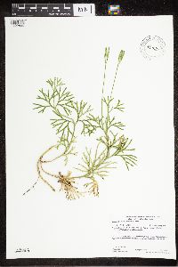 Diphasiastrum complanatum (L.) Holub 942293[1322806]Gerdes, Lynden B. 69642013-07-24 United States, Minnesota, Saint Louis, Approximately 4.43 miles north of Ely, MN. Within the the "old lake basin". NESE of section;Bass Lake Trail / Superior National Forest;63N;12W;03, 47.967291 -91.847296 |
MIN:Plants | 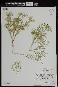 939001[1294752]Anderson, Chel E. 23152013-08-01 United States, Minnesota, Saint Louis, T66N R13W Section 3 NW 1/4 of the SW 1/4, UTM(NAD83): 5342464/574869, 48.230975 -91.99181935876 |
MIN:Plants |  943991[1294751]Anderson, Chel E. 23482014-08-20 United States, Minnesota, Saint Louis, T67N R17W Section 30 NE 1/4 of the NW 1/4, UTM(NAD83): 531387/5345738, 48.264073 -92.57707408056 |
MIN:Plants |  946470[1289949]Gerdes, Lynden B. 55492008-06-11 United States, Minnesota, Saint Louis, Superior National Forest. Low Lake. Approximately 4.45 miles NNW of Ely, MN. Semi-open area within 25m of the Bass Lake hiking trail. NESE of section; T063N R12W sec03, 47.96799 -91.843549 |
MIN:Plants |  946474[1289945]Gerdes, Lynden B. 55112007-08-14 United States, Minnesota, Lake, Superior National Forest. Approximately 9.15 miles WNW of Isabella, MN and 0.31 miles east of the Northwest Road (FR 373). NESE of section; T061N R08W sec19, 47.750658 -91.394556 |
MIN:Plants |  950729[1290069]Perry, Ethan F. 140242014-08-15 United States, Minnesota, Saint Louis, T57N R16W NW1/4 of NE1/4 of Sec1; 5.3 miles southeast of Gilbert; 1.4 miles west of Lost Lake boat landing, 47.42646 -92.39845 |
MIN:Plants |  952894[1295592]Kerns, Courtney CKK01382014-08-28 United States, Minnesota, Koochiching, 48.3019 -93.38384 |
MIN:Plants |  952121[1297220]Smith, Welby R. 349882014-06-25 United States, Minnesota, Saint Louis |
MIN:Plants |  55239[1322793]Rosendahl, C. 471902-05-17 United States, Minnesota, Clearwater, Lake Itasca, 47.214222 -95.196526 |
MIN:Plants |  702922[1327049]Riggs, Golda s.n.1968-08-26 United States, West Virginia, Monongalia, 4 1/2 miles from Laurel Point on Laurel Point-Cassville Road, 39.675949 -79.941933 |
MIN:Plants |  452476[1327050]Wiegand, K.M. s.n.1892-12-20 United States, New Jersey, Trenton |
Google Map
Google Maps is a web mapping service provided by Google that features a map that users can pan (by dragging the mouse) and zoom (by using the mouse wheel). Collection points are displayed as colored markers that when clicked on, displays the full information for that collection. When multiple species are queried (separated by semi-colons), different colored markers denote each individual species.