University of Minnesota
http://www.umn.edu/
612-625-5000
http://www.umn.edu/
612-625-5000
Minnesota Biodiversity Atlas
Bell Museum
Dataset: MIN-Plants
Taxa: Trifolium
Search Criteria: excluding cultivated/captive occurrences
Bell Museum plants | |
 MIN:Plants |  Trifolium wormskioldii Lehmann 410794[1079528]Heller, A. 73581904-04-27 United States, California, San Francisco, San Francisco. From type locality, near U.S. Marine Hospital. |
MIN:Plants |  937606[1122831]Gerdes, Lynden B.; Bach, Melissa J. 65552012-06-22 United States, Minnesota, Lake, North Kawishiwi River. Approximately 11.07 miles east of Ely, MN and 0.39 miles SW of Conchu Lake. Towards eastern end of longer portage.;Boundary Waters Canoe Area Wilderness / Superior National Forest;063N;10W;28, 47.918611 -91.604167 |
MIN:Plants |  937607[1122823]Gerdes, Lynden B.; Bach, Melissa J. 65562012-06-22 United States, Minnesota, Lake, North Kawishiwi River. Approximately 11.07 miles east of Ely, MN and 0.39 miles SW of Conchu Lake. Towards eastern end of longer portage.;Boundary Waters Canoe Area Wilderness / Superior National Forest;063N;10W;28, 47.918611 -91.604167 |
MIN:Plants |  937627[1122832]Gerdes, Lynden B. 65822012-07-09 United States, Minnesota, Lake, Little Isabella River Campgrounds approximately 3.87 miles northwest of Isabella, MN. Vicinity of south eastern most campsite.;Superior National Forest;060N;09W;25, 47.6475 -91.4225 |
MIN:Plants |  937631[1122822]Gerdes, Lynden B. 65862012-07-09 United States, Minnesota, Lake, Approximately 4.22 miles northwest of Isabella, MN and 0.40 west of the Hwy. 1 entrance to the Little Isabella River Campgrounds.;Superior National Forest;060N;09W;35, 47.646111 -91.4325 |
MIN:Plants |  937637[1122818]Gerdes, Lynden B. 65932012-07-09 United States, Minnesota, Lake, East Chub Lake area, approximately 13.42 miles northwest of Isabella, MN.;Superior National Forest;060N;10W;17, 47.683333 -91.623333 |
MIN:Plants |  Trifolium aureum Pollich 937711[1122814]Gerdes, Lynden B. 66802012-08-06 United States, Minnesota, Lake, Approximately 4.94 miles northwest of Isabella, MN. West Fish Fry Lake.;Superior National Forest;060N;09W;26, 47.647222 -91.449444 |
MIN:Plants |  Trifolium campestre Schreber 937712[1122815]Gerdes, Lynden B. 66812012-08-06 United States, Minnesota, Lake, Slate Lake area, Gerdes homestead. Approximately 14.35 miles NW of Isabella, MN.;Superior National Forest;060N;10W;08, 47.695278 -91.637778 |
MIN:Plants |  951344[1290238]Dziuk, Peter M. PMD16-0232016-08-03 United States, Minnesota, Pennington, Thief River Falls, S&W side of Hwy 59, .25 miles N-W of Hwy 59 junc with CoRd 62. In mowed ditch between frontage road and 59. T153N, R43W, sec 2, 48.137191 -96.175395 |
MIN:Plants |  953440[1292773]Anonymous s.n. United States, Minnesota, Rice, Northfield, 44.458298 -93.161604 |
MIN:Plants |  953441[1292772]Rummels, Amy G. s.n.1896-05-09 United States, Minnesota, Goodhue, Zumbrota, 44.294132 -92.669081 |
MIN:Plants |  953442[1292771]Sargeant, W. s.n. United States, Minnesota, Goodhue, Cannon River Valley, 44.585648 -92.557156 |
MIN:Plants |  953443[1292770]Fairbank, Chandler s.n.1928-00-00 United States, Minnesota, Rice, Northfield, 44.458298 -93.161604 |
MIN:Plants |  953444[1292769]Thomas, Barbara s.n. United States, Minnesota, Rice |
MIN:Plants |  953445[1292768]KenKnight, Glenn s.n.1933-08-11 United States, Minnesota, Canon River Valley, 44.585801 -92.556858 |
MIN:Plants |  954229[1295807]Jenkins, F. E. s.n.1891-06-00 United States, Nebraska, Boone |
MIN:Plants | 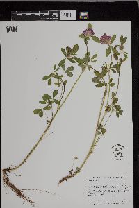 953125[1296420]Lee, Jeffrey G. 1032015-06-23 United States, Minnesota, Saint Louis |
MIN:Plants |  Trifolium tridentatum Lindl. 959653[1311933]Elizabeth Oliver 1933-04-02 United States, California, Napa, Near Yountville |
MIN:Plants |  Trifolium tridentatum Lindl. 959652[1311934]Elizabeth Oliver 1933-03-23 United States, California, Near Patcheco |
MIN:Plants |  Trifolium tridentatum Lindl. 959651[1311935]WD Chick 34471934-04-08 United States, California, Contra costa, Mt Diablo State Park, 610m |
MIN:Plants | 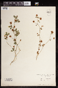 959650[1311936]Pearl Paulson 1928-00-00 Switzerland |
MIN:Plants |  959649[1311937]Paul G. Wible 1928-08-01 United States, Indiana, Lawrence |
MIN:Plants |  959648[1311938]Marsh Sundberg 1969-06-15 United States, Wisconsin, Washburn, Tomahawk Scout Res. |
MIN:Plants |  959647[1311939]Paul G. Wible 1928-06-29 United States, Indiana, Lawrence |
MIN:Plants |  959646[1311940]Ellen F. Marsh 1886-06-03 United States |
MIN:Plants |  959645[1311941] 1892-07-00 United States, Nebraska |
MIN:Plants |  959644[1311942]Marsh Sundberg 1969-06-15 United States, Wisconsin, Washburn, Tomahawk Scout Res. |
MIN:Plants |  959643[1311943]Paul G. Wible 1928-07-23 United States, Indiana, Lawrence |
MIN:Plants |  959642[1311944]Pearl Paulson 1928-00-00 Switzerland |
MIN:Plants |  959641[1311945]Heimerl 1923-06-18 Austria |
MIN:Plants |  959640[1311946]Paul G. Wible 1928-07-06 United States, Indiana, Lawrence |
MIN:Plants |  959639[1311947]Heimerl 1923-07-23 Austria |
MIN:Plants |  Trifolium wormskioldii Lehmann 959638[1311948]Walter J. Eyerdam 1938-05-29 United States, Washington, Kitsap |
MIN:Plants |  Trifolium depauperatum Desv. 959637[1311949]Elizabeth Oliver 1933-04-02 United States, California, 8 miles north of Napa, 38.413122 -122.285529 |
MIN:Plants |  Trifolium bifidum A.Gray 959636[1311950]Elizabeth Oliver 1933-03-30 United States, California |
MIN:Plants |  959635[1311951]Bertha Linnell 1926-00-00 United States, Maine |
MIN:Plants |  959634[1311952]Margaret Dixon Fernstrom 61551900-06-12 Switzerland |
MIN:Plants |  959633[1311953] 1905-00-00 United States, Massachusetts |
MIN:Plants |  959632[1311954]May Mowery 1928-07-17 United States, Massachusetts |
MIN:Plants |  Trifolium campestre Schreber 959631[1311955] United States, Massachusetts |
MIN:Plants |  959630[1311956]May Mowery 1928-08-24 United States, Massachusetts |
MIN:Plants |  960528[1318948]Kramer, Leona 1927-00-00 United States, Minnesota, Mower |
MIN:Plants |  960532[1318949] 1953-09-01 United States, Minnesota, shores of Lake Superior, 46.871704 -91.951436 |
MIN:Plants |  960531[1318950] 1935-00-00 United States, Minnesota, Cass |
MIN:Plants |  960530[1318951]Marsh, Lucian 1935-00-00 United States, Minnesota, Cass |
MIN:Plants |  Trifolium aureum Pollich 960529[1318952]Kramer, Leona 1927-00-00 United States, Minnesota, Mower |
MIN:Plants |  Trifolium rydbergii Greene 960562[1329059]Stork, H.E. 32281927-08-00 United States, Wyoming, Yellowstone National Park, Mammoth Hot Springs |
MIN:Plants |  960763[1329368]Lee, Michael MDL32482002-08-27 United States, Minnesota, Lake, Strongly rolling morainal terrain northwest of Spur Lake, seven miles east of Isabella. Local in an old log landing along a two track logging road (#358) east of the General Grade Forest Road (#362). N1/2 of SE1/4 of NW1/4 Sec. 10, Superior National Forest, 47.60939 -91.203627 |
MIN:Plants | 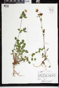 960771[1329376]Lee, Michael MDL32492002-08-27 United States, Minnesota, Lake, Strongly rolling morainal terrain northwest of Spur Lake, seven miles east of Isabella. Local in an old log landing along a two track logging road (#358) east of the General Grade Forest Road (#362). N1/2 of SE1/4 of NW1/4 Sec. 10, Superior National Forest, 47.60939 -91.203627 |
MIN:Plants |  960774[1329379]Lee, Michael MDL3315A2002-09-13 United States, Minnesota, Lake, Along Highway 61 in rugged bedrock terrain ~1/4-mile southwest of the Manitou River bridge, three miles northeast of Little Marais. NW1/4 of NE1/4 Sec. 10, 47.444015 -91.068992 |
MIN:Plants |  963100[1346831]Whitfeld, T.J.S. 24232019-08-29 United States, Minnesota, Cass, Us Army Corps of Engineers Winnibigoshish Recreation Area, dam-roadside, 47.428019 -94.053619 |
MIN:Plants |  960990[1334070]Boyd, Crystal CLB2016292016-08-22 United States, Minnesota, Marshall, Huntly WMA. 1.5 miles NW of Middle River. 1 mile west on Co. Hwy 6. 0.5 miles north on 130th St. T157N R43W Sec. 4; 48.45452 -96.19127, 48.45452 -96.19127 |
MIN:Plants | 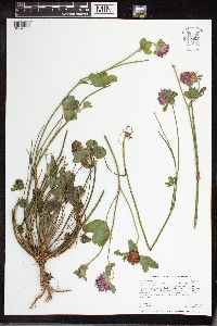 961005[1334085]Melissa J Bach MJB0052016-06-27 United States, Minnesota, Lincoln, Hole-in-the-Mountain. 7 miles east of South Dakota/Minnesota border. 3 miles south of Lake Benton. 3/4 mile north of Co. Hwy. 9. Along west side of U.S. Highway 75. T109N R45W SW1/4 of SW1/4 of Sec. 17, 44.24032 -96.29879 |
MIN:Plants | 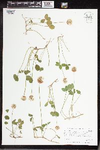 961006[1334086]Melissa J Bach MJB0042016-06-27 United States, Minnesota, Jackson, Des Moines SNA. 5 miles south of Windom. 1/2 mile east of Co. Hwy. 17. East of public access to Des Moines River on Co. Hwy. 30. Near Public Water Access Parking. T104N R35W SW1/4 of SW1/4 of Sec. 19, 43.79266 -95.09164 |
MIN:Plants | 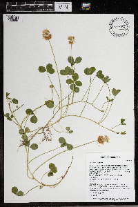 966094[1356855]T. J. S. Whitfeld 25572020-06-09 United States, Minnesota, Washington, Lost Valley Prairie Scientific and Natural Area, 2 miles east north east of intersection of State Highway 95 and 110th Street, at dead-end of Nyberg Avenue South., 44.802349 -92.821602, 281m |
MIN:Plants | 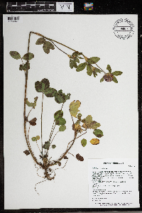 966096[1356857]T. J. S. Whitfeld 25682020-06-09 United States, Minnesota, Washington, Lost Valley Prairie Scientific and Natural Area, 2 miles east north east of intersection of State Highway 95 and 110th Street, at dead-end of Nyberg Avenue South., 44.802157 -92.818336, 276m |
MIN:Plants | 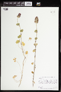 962622[1346056]Graham, Dustin R. J. DRJG182015-07-07 United States, Minnesota, Pennington, 3 miles W and 0.75 miles S of St. Hilare. Follow small access road along top of the beach ridge ;T152N R44W SE1/4 of NW1/4 Sec 9, 47.99948 -96.3001, 331m |
MIN:Plants | [] 1933-07-03 United States, New York, Cayuga Heights |
MIN:Plants | [] 1933-07-03 United States, New York, Near Georgetown |
MIN:Plants | [] 1933-07-03 United States, New York, Cayuga Heights Manor |
MIN:Plants | 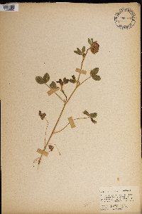 965890[1356650] 1944-07-13 United States, District of Columbia, In front of Curley Hall. Catholic University |
MIN:Plants | 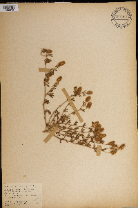 965916[1356675] 1944-07-16 United States, District of Columbia, Catholic University Campus. North of Arch. Curley Hall. |
MIN:Plants | 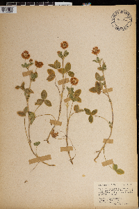 965911[1356680] 1944-07-16 United States, District of Columbia, Catholic University Campus, north of Arch Curley Hall. |
MIN:Plants |  965955[1356711]Sr. St. Mark 1947-08-09 United States, Minnesota |
MIN:Plants |  967648[1368200] s.n.1971-07-27 United States, Minnesota, Clearwater, Iron Springs Bog; T144N R36W sec. 28 SW 1/4, 47.257678 -95.249751 |
MIN:Plants | []Timothy J. S. Whitfeld 33162022-07-06 United States, Minnesota, Swift, Appleton 18 Native Prairie Bank, 3.75 miles west of Appleton, 45.199443 -96.098868, 294m |
MIN:Plants | []Timothy J. S. Whitfeld 33182022-07-06 United States, Minnesota, Swift, Appleton 18 Native Prairie Bank, 3.75 miles west of Appleton, 45.199443 -96.098868, 294m |
MIN:Plants |  821047[1369443]Hunn, J 51981-03-10 Egypt, in Akhmim |
MIN:Plants |  738270[1369444]John Hunn 51981-03-10 Egypt |
MIN:Plants |  Trifolium africanum Ser. 143959[1369445]J. Medly Wood 9021890-12-00 South Africa, KwaZulu-Natal, Weenen country, 4000 - 5000m |
MIN:Plants |  143075[1369446]Alice Carter Cook 3051897-03-00 Spain, Canary Islands. Gran Canaria: Guía |
MIN:Plants |  Trifolium acaule Steud. ex A. Rich. 717287[1369447]Gilbert, H. G. 19161970-10-22 Ethiopia, Entoto, 7km. from Addis Abebe on Gondar Rd., 2900m |
MIN:Plants | []Timothy J. S. Whitfeld 32062022-06-16 United States, Minnesota, Washington, Crystal Spring Scientific and Natural Area, 0.4 miles northeast of the intersection of Scandia Trail North and Hwy 95, 45.26102 -92.768304, 284m |
MIN:Plants |  969592[1372082] s.n.1933-07-03 United States, New York, Cayuga Heights |
MIN:Plants | 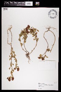 969595[1372085] s.n.1933-07-03 United States, New York, Georgetown |
MIN:Plants | 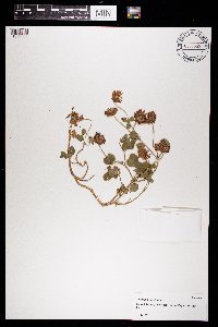 969599[1372089] s.n.1933-07-03 United States, New York, Cayuga Heights Manor |
MIN:Plants | []Timothy J. S. Whitfeld 32492022-07-01 United States, Minnesota, Washington, Crystal Spring Scientific and Natural Area, 0.4 miles northeast of the intersection of Scandia Trail North and Hwy 95, 45.262822 -92.768426, 285m |
MIN:Plants | 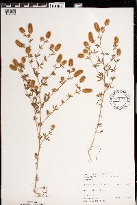 971329[1394810]Janssens, J. 74/1841975-07-21 Belgium, Antwerpen, Kiel., 15m |
MIN:Plants | 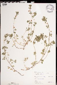 Trifolium dubium Sibth. 971330[1394811]Janssens, J. 75/891975-05-24 Belgium, Antwerpen, Hoboken C 45623 |
MIN:Plants |  971331[1394812]Janssens, J. 75/931975-05-24 Belgium, Hoboken Polder |
MIN:Plants |  972051[1395786]Verbelen, E. 1351974-04-27 Belgium, Kiel |
MIN:Plants |  972050[1395785]Verbelen, E. 1581974-06-09 Belgium, Kiel |
MIN:Plants | Trifolium longipes Nutt. []Allen, A. GW25232005-06-29 United States, Colorado, Gunnison, Bracken Creek, Kebler Pass Road, 38.851333 -107.106667, 3024m |
MIN:Plants | Trifolium longipes Nutt. []Ikemeier, A. GW26312005-06-29 United States, Colorado, Delta, Private property, along Rotcap Creek, Pitkin Mesa, 38.870528 -107.638472, 1808m |
MIN:Plants | []Kerstin Griffin 551964-05-29 United States, Minnesota, Scott, 4 miles southwest Shakopee along Highway 169. Old pasture., 44.757043 -93.584623 |
MIN:Plants |  977721[1401328]Don Henson 1591971-06-17 United States, Michigan, Schoolcraft, NE1/4 NE1/4 Sec 23 T42N-R16W., 46.01948 -86.27196 |
MIN:Plants | 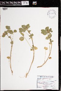 977722[1401329]Don Henson 1601971-06-17 United States, Michigan, Schoolcraft, NE1/4 NE1/4 Sec 23 T42N-R16W., 46.01948 -86.27196 |
MIN:Plants |  Trifolium aureum Pollich 978793[1401702]Don Henson 2931971-09-03 United States, Michigan, Schoolcraft, N 1/2 NW 1/4 Sec 1 T42N-R16W., 46.06329 -86.25116 |
Google Map
Google Maps is a web mapping service provided by Google that features a map that users can pan (by dragging the mouse) and zoom (by using the mouse wheel). Collection points are displayed as colored markers that when clicked on, displays the full information for that collection. When multiple species are queried (separated by semi-colons), different colored markers denote each individual species.