University of Minnesota
http://www.umn.edu/
612-625-5000
http://www.umn.edu/
612-625-5000
Minnesota Biodiversity Atlas
Bell Museum
Dataset: MIN-Plants
Taxa: Alliaceae
Search Criteria: excluding cultivated/captive occurrences
Bell Museum plants | |
 MIN:Plants | 87335[]Skinner, S. 181902-06-09 United States, Minnesota, Jackson, Vic. of Heron Lake.;;N;;, 43.794959 -95.320276 |
MIN:Plants | 87336[]Taylor, B. T6211891-07-00 United States, Minnesota, Faribault, Minnesota Lake.;;N;;, 43.841904 -93.831895 |
MIN:Plants | 87337[]Ballard, C. B1061891-06-00 United States, Minnesota, Carver, Carver;;115N;23W;, 44.7615667 -93.581604 |
MIN:Plants | 87338[]Ballard, C. B3551891-06-00 United States, Minnesota, Scott, Helena, Scott Co.;;113N;23W;, 44.5870522 -93.5832928 |
MIN:Plants | 87339[]Moyer, Lycurgus s.n.1896-06-20 United States, Minnesota, Chippewa, Montevideo.;;117N;40W;, 44.9346263 -95.6757744 |
MIN:Plants | 87341[]Menzel, Max s.n.1895-06-00 United States, Minnesota, Pipestone, Pipestone [assuming the quarry area; town generally noted as Pipestone City by collector];Pipestone National Monument;106N;46W;01, 44.01585 -96.31767 |
MIN:Plants | 87342[]Wheeler, William 11971902-06-04 United States, Minnesota, Winona, Winona;;N;;, 43.990802 -91.743423 |
MIN:Plants | 87343[]Wheeler, William 12041902-06-04 United States, Minnesota, Winona, Winona;;N;;, 43.990802 -91.743423 |
MIN:Plants | 87344[]Taylor, B. T5181891-06-00 United States, Minnesota, Waseca, Mud Lake.;;N;;, 44.027711 -93.574068 |
MIN:Plants | 87345[]Sandberg, John s.n1882-07-00 United States, Minnesota, Goodhue, Vasa.;;N;;, 44.5033 -92.72242 |
MIN:Plants | 87346[]Aiton, G. s.n.1889-08-00 United States, Minnesota, Rice, Rice Co.;;;;, 44.354262 -93.296678 |
MIN:Plants | 87349[]Campbell, Jennie s.n.1897-06-00 United States, Minnesota, Stearns, Sauk River. Stearns Co.;;N;;, 45.505389 -94.723001 |
MIN:Plants | 913238[]Smith, Welby 228111993-07-12 United States, Minnesota, Freeborn, Freeborn County...Between CSAH 46 and the Soo Line Railroad tracks, about 8 miles east of Albert Lea...T102N R20W NW1/4 of SW1/4 of sec 1. 102N 20W 1, 43.6638889 -93.1897222 |
MIN:Plants | 599414[]Tryon, R. 10971935-06-21 United States, Indiana, Porter, Dunes State Park, Porter Co.;Indiana Dunes National Lakeshore;;;, 41.663093 -87.032128 |
MIN:Plants | 926388[]Schimpf, D. DJS6302011-07-14 United States, Minnesota, Saint Louis, Duluth; powerline corridor between First St. & Third St.;;050N;14W;33, 46.7738889 -92.1193056 |
MIN:Plants | 926386[]Schimpf, D. DJS6222011-07-08 United States, Minnesota, Saint Louis, Duluth.;;050N;14W;33, 46.7734722 -92.1223611 |
MIN:Plants |  960462[1329010]Kramer, Leona 1927-00-00 United States, Minnesota, Mower |
MIN:Plants | Allium obtusum var. obtusum Lemmon 236738[]Congdon, J. s.n.1890-08-11 United States, California, Mariposa, Glacier Lake, Mariposa County;Yosemite National Park |
MIN:Plants |  480751[1343680]Wheeler, Gerald 202971999-08-13 United States, Minnesota, Scott, Scott County ... Ca. 1 mi. W of Belle Plaine on Rte. 6, S of road ... NW1/4 SE1/4 Sec. 2 T113N R25W (Blakeley 2);;113N;25W;02, 44.6227712 -93.798779 |
MIN:Plants |  509242[1343678]Wheeler, Gerald 193861998-06-23 United States, Minnesota, Carver, Carver County ... Ca. 4 mi. SSW of East Union; between Kelly Lake and Hallquist Lake ... SW1/4 NE1/4 Sec. 21 T114N R24W;;114N;24W;21, 44.663581 -93.712406 |
MIN:Plants |  457187[1343676]Boe, J.; et al. 940512051994-05-12 United States, Minnesota, Cass, Chippewa National Forest / Leech Lake Indian Reservation. Cass County...Bear Island in Leech Lake. Chippewa National Forest. Walker Dist, Comp.32...T 142N R 29W SE1/4 of NW1/4 of Sec 2. 142N 29W 2, 47.147362 -94.3074726 |
MIN:Plants | 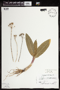 835983[1343675]Myhre, K. 34771993-04-25 United States, Minnesota, Pine, Pine County...Located 6 mi W of the town of Sandstone...T42N R21W NE1/4 of NE1/4 of Sec 21;;042N;21W;21, 46.1074955 -93.0023894 |
MIN:Plants | 356753[]Moore, John; et al. 123231940-04-28 United States, Minnesota, Carver, Highway 212, two miles west of Cologne, Carver County;;115N;25W;15, 44.7677246 -93.8185098 |
MIN:Plants | 526240[]Moore, John 210831951-06-26 United States, Minnesota, Todd, Todd County ... Growing along the river ... 1/2 mile north east of Philbrook.;;133N;32W;34, 46.2895169 -94.7052346 |
MIN:Plants | 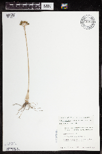 669882[1343674]Grimm, Eric 691974-08-07 United States, Minnesota, Hennepin, Hennepin County ... YMCA Camp Ihduhapi, Loretto. YMCA Camp Ihduhapi, Loretto.. 118N 24W 12, 45.0438361 -93.6559813 |
MIN:Plants | 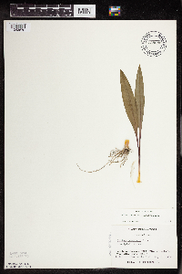 738686[1343679]Galatowitsch, S. 181982-05-01 United States, Minnesota, Goodhue, Grace Nature Preserve. Goodhue County ... T109N, R18W, parts of NW1/4 SW1/4 and SW1/4 SW1/4 of Sec. 8.;Grace Nature Preserve, The Nature Conservancy;109N;18W;08, 44.2620117 -93.0105438 |
MIN:Plants | 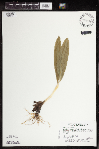 838420[1343673]Myhre, K. 3478A1993-04-25 United States, Minnesota, Pine, Pine Co. Located 6 mi W of the town of Sandstone; T42N R21W NE1/4 of NE1/4 of Sec 21.;;042N;21W;21, 46.1074955 -93.0023894 |
MIN:Plants | 87759[]Frost, W. 1961892-06-00 United States, Minnesota, Meeker, Hope Lake, Acton Twp. Meeker Co.;;119N;32W;25, 45.0876615 -94.6447657 |
MIN:Plants | 87760[]Ballard, C. B2911891-06-00 United States, Minnesota, Scott, Jordan. Scott Co.;;114N;23W;19, 44.6669697 -93.6339864 |
MIN:Plants | 87762[]Herrick, C. s.n.1878-07-00 United States, Minnesota, Hennepin, Minneapolis;;029N;24W;25, 44.9699591 -93.2370211 |
MIN:Plants | 87764[]Sheldon, Edmund 10071891-07-00 United States, Minnesota, Brown, Sleepy Eye.;;110N;32W;32, 44.2899554 -94.7154373 |
MIN:Plants | 87768[]Holzinger, John s.n.1886-06-00 United States, Minnesota, Winona, Winona Co.;;;;, 43.990802 -91.743423 |
MIN:Plants |  435866[1343677]Wheeler, Gerald 156901997-05-24 United States, Minnesota, Nicollet, Fort Ridgely State Park. Nicollet County...Fort Ridgely State Park; 0.6 mi. NW of jct. of Rte. 4 and Rte. 5...W1/2 NE1/4 NE1/4 Sec. 6 T111N R32W (Ridgely 6). 111N 32W 6, 44.443975 -94.7414917 |
MIN:Plants |  974750[1397517]Dunevitz, Hannah L. 8621992-08-26 United States, Minnesota, Goodhue, One mile west of the city of Mazeppa, on a steep north-facing bluff on the south side of the Zumbro River., 44.28 -92.57 |
MIN:Plants | 433003[]Lee, Michael MDL14761996-08-09 United States, Minnesota, Aitkin, Aitkin County ... Wealthwood State Forest one mile northeast of Wealthwood ... T45N R26W SW1/4 SW1/4 SW1/4 Sec. 16;Wealthwood State Forest;045N;26W;16, 46.3813043 -93.6328462 |
MIN:Plants | 931606[]Lee, Michael MDL46042008-06-12 United States, Minnesota, Cass, 5.5 miles northeast of Leader, 12 miles west of Pequot Lakes. NE1/4 of SE1/4 of NW1/4 of section;;136N;31W;22, 46.5830636 -94.5730325 |
MIN:Plants | 920950[]Lee, Michael MDL33402003-05-23 United States, Minnesota, Todd, Oak Ridge Wildlife Management Area. Todd County...Oak Ridge Wildlife Management Area...between Mound and Cedar lakes, five miles east of Grey Eagle... west of Nellies Lake...T127N R32W N1/2 of SE1/4 of SW1/4 Sec. 1; N1/2 of SE1/4 of SE1/4 Sec. 1. 127N 32W 1, 45.8385916 -94.6540764 |
MIN:Plants |  441750[1343682]Lee, Michael MDL15251996-08-30 United States, Minnesota, Mille Lacs, Mille Lacs County...On the east side of (Lake) Mille Lacs 3.5 miles north of Isle along HWY 47...between the highway & the lake...T43N R25W NE1/4 SW1/4 SW1/4 Sec. 22. 043N 25W 22, 46.1905389 -93.4824932 |
MIN:Plants | 792091[]Smith, Welby 105901985-07-01 United States, Minnesota, Stearns, Partch Woods Scientific Natural Area. Stearns County...Partch Woods State Scientific and Natural Area, about 3 1/2 mi east-northeast of Avon...Sec.19 SE1/4 NW1/4, T125N R29W. 125N 29W 19, 45.6222222 -94.3777778 |
MIN:Plants | 229698[]Rosendahl, C. 24371910-04-13 United States, Minnesota, Ft. Snelling Reservation [old regional park spanning junction of Minnesota and Mississippi rivers].;Fort Snelling Reservation [former regional park];028N;23W;, 44.90516 -93.16646 |
MIN:Plants | 264177[]Holzinger, John s.n.1905-05-00 United States, Minnesota, Winona, Bear Creek etc. ... in Winona Co.;;107N;09W;00, 44.063494 -91.8992605 |
MIN:Plants | 304245[]Lakela, Olga 12951935-09-08 United States, Minnesota, Saint Louis, N.W. of Chester Park School, Duluth;;050N;14W;00, 46.8115792 -92.1190428 |
MIN:Plants | 337390[]Linnaean Club, U of M, 3031943-07-10 United States, Minnesota, Rice, Nerstrand Woods. Rice Co. ... below falls.;Nerstrand Woods State Park;110N;19W;09, 44.3488713 -93.1110812 |
MIN:Plants | 345947[]Lakela, Olga 18921937-05-08 United States, Minnesota, Saint Louis, S.W. slope of Hunter's Hill, Duluth.;;;;, 46.783273 -92.106579 |
MIN:Plants | 354046[]Lakela, Olga 25601938-07-17 United States, Minnesota, Saint Louis, along Hartley Road, Duluth.;;;;, 46.783273 -92.106579 |
MIN:Plants | 356475[]Lakela, Olga 28701939-05-16 United States, Minnesota, Saint Louis, on Bardon's Peak, Skyline Parkway, Duluth.;;;;, 46.682089 -92.232971 |
MIN:Plants | 356735[]Moore, John; et al. 123101940-04-27 United States, Minnesota, Lincoln, 3/4 mile S.W. of Lake Benton, over the hill from Highway 75, Lincoln County;Hole-in-the-Mountain Prairie, The Nature Conservancy;109N;45W;17, 44.2482766 -96.2909813 |
MIN:Plants | 356757[]Moore, John; et al. 123191940-04-28 United States, Minnesota, Renville, North side of ravine of the Minnesota River, on Highway 19, two miles east of Morton. Renville County;;112N;34W;05, 44.5307791 -94.9613177 |
MIN:Plants | 362164[]Moyle, J. 34761940-07-10 United States, Minnesota, Saint Louis, along Sucker R. St. Louis Co.;;;;, 48.012655 -92.952657 |
MIN:Plants | 367544[]Moore, John; et al. 123671940-05-16 United States, Minnesota, Rice, seven miles south of Faribault, along Highway 218 [298?], Rice Co.;;109N;20W;00, 44.2399484 -93.2223795 |
MIN:Plants | 367604[]Moore, John; et al. 123811940-05-16 United States, Minnesota, Steele, south edge of Owatonna, Steele County;;107N;20W;00, 44.0661118 -93.2260713 |
MIN:Plants | 367656[]Moore, John; et al. 125691940-05-25 United States, Minnesota, Wright, S.W. 1/4, S.36, South Side Townchip, Wright County;;121N;28W;36, 45.2461928 -94.1473271 |
MIN:Plants | 367696[]Moore, John; et al. 125211940-05-18 United States, Minnesota, Fillmore, 4 miles west of Harmony, Fillmore County;;101N;10W;07, 43.5657281 -92.0795175 |
MIN:Plants | 367722[]Moore, John; et al. 126231940-05-25 United States, Minnesota, Meeker, 3/4 mile west of Eden Valley, on Highway 55, Meeker County;;121N;31W;03, 45.3187421 -94.5567907 |
MIN:Plants | 367740[]Moore, John; et al. 125961940-05-25 United States, Minnesota, Stearns, railroad right-of-way and Highway No. 55, 1.3 miles west of Kimball, Stearns County;;121N;29W;04, 45.3191599 -94.3332848 |
MIN:Plants | 367770[]Moore, John; et al. 124451940-05-17 United States, Minnesota, Mower, Red Cedar River, five miles south of Austin on Highway 105, Mower County.;;102N;18W;00, 43.6304349 -92.9895025 |
MIN:Plants | 367916[]Moore, John; et al. 128781940-05-28 United States, Minnesota, Big Stone, near Big Stone Lake; 1 mile north of Ortonville, Big Stone Co.;;121N;46W;09, 45.3051502 -96.4413108 |
MIN:Plants | 368095[]Moore, John; et al. 127561940-05-25 United States, Minnesota, Pope, N.W. 1/4, Section 14, Levens Township, Pope County;;126N;37W;14, 45.7226592 -95.2937101 |
MIN:Plants | 368256[]Moore, John; et al. 128221940-05-27 United States, Minnesota, Grant, S.E. 1/4, Section 10, Pelican Lake Township, Grant County;;130N;41W;10, 46.0859436 -95.8217945 |
MIN:Plants | 368281[]Moore, John; et al. 127461940-05-25 United States, Minnesota, Douglas, 1/2 mile east of Brandon, Douglas County;;129N;39W;21, 45.9694677 -95.5929933 |
MIN:Plants | 369957[]Moore, John; et al. 140741941-05-24 United States, Minnesota, Chisago, 1-1/2 miles north-east of Rush City, S.W.1/4, Section 14, Rushseba Township, Chicago County;;037N;21W;14, 45.6949283 -92.9294744 |
MIN:Plants | 370334[]Moore, John; et al. 137451941-04-26 United States, Minnesota, Washington, 1/2 mile south of Inver Grove Bridge, St. Paul Park, Washington County;;027N;22W;12, 44.8406462 -92.9938981 |
MIN:Plants | 374070[]Linnaean Club, U of M, 1051940-05-05 United States, Minnesota, Rice, Nerstrand Woods. Rice Co.;Nerstrand Woods State Park;110N;19W;09, 44.3488713 -93.1110812 |
MIN:Plants | 374088[]Lakela, Olga 50961942-07-31 United States, Minnesota, Saint Louis, on St. Mary's Hill, Duluth;;;;, 46.783273 -92.106579 |
MIN:Plants | 442052[]Moore, John; Huff, N. 184421945-04-17 United States, Minnesota, Goodhue, Goodhue County ... creek 1-1/2 miles south west of Kenyon.;;109N;18W;00, 44.2402948 -92.9805193 |
MIN:Plants | 444954[]Moore, John; et al. 194801947-06-07 United States, Minnesota, Morrison, Morrison Co.; 5 miles south west of Randall.;;130N;31W;, 46.0640829 -94.5814294 |
MIN:Plants | 444969[]Moore, John; Huff, N. 194371947-06-03 United States, Minnesota, Beltrami, Beltrami County...Red Lake Penninsula 4 miles west of Ponemah.;Red Lake Indian Reservation;153N;34W;35, 48.0275486 -94.9744655 |
MIN:Plants | 445003[]Moore, John; Huff, N. 191601946-08-30 United States, Minnesota, Beltrami, Beltrami County...4 miles north west of Panemah [sic].;Red Lake Indian Reservation;153N;34W;35, 48.0275486 -94.9744655 |
MIN:Plants | 446237[]Moore, John; Huff, N. 188971946-08-01 United States, Minnesota, Benton, Benton County ... 2 miles south west of Foley.;;037N;29W;33, 45.6550814 -93.9567811 |
MIN:Plants | 488754[]Moore, John 200461949-06-01 United States, Minnesota, Otter Tail, Otter Tail County...7 miles south of Perham.;;135N;39W;22, 46.4917655 -95.5845575 |
MIN:Plants | 497452[]Moore, John 203101949-06-27 United States, Minnesota, Otter Tail, Otter Tail County ... 1-1/2 miles west of Dopelius [unknown historical village];;;;, 46.4791667 -95.2861111 |
MIN:Plants | 500817[]Moore, John 204881950-05-24 United States, Minnesota, Freeborn, Freeborn County ... 1 mile north of Emmons.;;101N;22W;28, 43.5213905 -93.4782051 |
MIN:Plants | 542545[]Moore, John 214361952-05-06 United States, Minnesota, Murray, Murray County...Growing along the north shore of peninsula, Lake Shetek State Park.;Lake Shetek State Park;108N;40W;31, 44.1162712 -95.693337 |
MIN:Plants | 543340[]Lakela, Olga 212751957-05-19 United States, Minnesota, Lake, Gooseberry River, Upper Falls. Lake Co.;Gooseberry Falls State Park / North Shore;054N;09W;22, 47.1492937 -91.4639107 |
MIN:Plants | 552294[]Moyle, J. 42041946-05-02 United States, Minnesota, Winona, Whitewater River bottoms near Elba, Winona Co.;;107N;10W;00, 44.0634417 -92.0192595 |
MIN:Plants | 554660[]Moore, John 231041957-05-28 United States, Minnesota, Clay, Clay County ... Growing along the river ... at Ulen;;142N;44W;00, 47.1076793 -96.2582843 |
MIN:Plants | 558278[]Moore, John 236941958-05-25 United States, Minnesota, Blue Earth, Blue Earth County ... 1 mile west of Cambria.;;109N;29W;16, 44.2442134 -94.3238027 |
MIN:Plants | 603697[]Moore, John; et al. 268441966-05-30 United States, Minnesota, Blue Earth, Blue Earth County...along the Maple River, 1 mile east of Goodthunder.;;106N;27W;10, 44.0002076 -94.0586412 |
MIN:Plants | 615965[]Ownbey, Gerald 43091969-08-01 United States, Minnesota, Clearwater, Clearwater County...Itasca State Park, Bear Paw Point, Lake Itasca, s. of Biological Station [UM For/Bio Station].;Itasca State Park;143N;36W;11, 47.2175215 -95.2014955 |
MIN:Plants | 616580[]Moore, John; et al. 231969-05-09 United States, Minnesota, Crow Wing, Crow Wing Natural History Area. Crow Wing County...east of Chandler Lake, S.W. 1/4, Sect. 22, Garrison Twp.;Crow Wing Natural Area;044N;28W;22, 46.2789902 -93.8633363 |
MIN:Plants | 680809[]Wheeler, Gerald 9851977-04-18 United States, Minnesota, Carver, Carver County...Approximately 1/4 mile west of Stone Lake on Highway 7...T 116 N R 24 W Sec. 3;Carver Park Reserve County Park;116N;24W;03, 44.8841243 -93.6933678 |
MIN:Plants | 685036[]Stassen, Carol 131976-04-29 United States, Minnesota, Lyon, Lyon County ... Camden State Park, T 110N R 42W Sec 5;Camden State Park;110N;42W;05, 44.3631806 -95.9274434 |
MIN:Plants | 685112[]Stassen, Carol 1641977-06-27 United States, Minnesota, Lyon, Lyon County ... Camden State Park; T 111N R 42W Sec 32 SE1/4;Camden State Park;111N;42W;32, 44.3778973 -95.9275884 |
MIN:Plants | 690516[]Siemers, Ross 631977-06-14 United States, Minnesota, Morrison, Morrison County...MacDougall Homestead Preserve, about 15 miles southeast of Little Falls...T 39 N R 32 W Sec(s) 28 & 29;MacDougall Homestead, The Nature Conservancy;039N;32W;28, 45.8688557 -94.31068 |
MIN:Plants | 691051[]Sperling, C. 351976-05-07 United States, Minnesota, Douglas, Douglas County ... 3 miles south, 3 1/2 miles west of Holmes City.;;127N;39W;20, 45.7957959 -95.6032329 |
MIN:Plants | 696503[]Smith, Welby 6931978-07-09 United States, Minnesota, Wright, Wright County...T. 122N. R. 26W. S.W.1/4 section 35. Harry Larson County Park.;Harry Larson County Forest;122N;26W;35, 45.333902 -93.929411 |
MIN:Plants | 697770[]Ownbey, Gerald 52291976-03-08 United States, Minnesota, Cass, Cass County ... T 143 N, R 30 W, NE 1/4, Sec.22, Ottertail Peninsula.;Chippewa National Forest / Leech Lake Indian Reservation;143N;30W;22, 47.1857034 -94.4562114 |
MIN:Plants | 701621[]Ownbey, Gerald 63011979-07-15 United States, Minnesota, Fillmore, Dorer Memorial Hardwood State Forest. Fillmore County...T103N, R8W, NE1/4 and NW1/4, Sect. 31. S side of U.S. 16, 1.6 miles SW of its jct. with the turnoff to Peterson.. 103N 08W 31, 43.6811087 -91.8399822 |
MIN:Plants | 708393[]Ownbey, Gerald 65391979-09-17 United States, Minnesota, Washington, Washington County.T 32 N, R 19 W, Sect. 21, NE 1/4. Wm. O'Brien State Park along St. Croix River. N end of camping area.;William O'Brien State Park;032N;19W;31, 45.2517111 -92.7650957 |
MIN:Plants | 708478[]Wheeler, Gerald 34321979-05-12 United States, Minnesota, Washington, Washington County...Approx. 2 miles south of Marine on St. Croix. just east of Highway 95...Arcola Trail. May Township.;;031N;20W;00, 45.1667856 -92.8359084 |
MIN:Plants | 709874[]Wheeler, Gerald 48941979-08-08 United States, Minnesota, Rice, About 3.5 miles south-southwest of Dundas...overlooking the Cannon River (W bank).;Cannon River Wilderness Park;111N;20W;33, 44.3777328 -93.2314298 |
MIN:Plants | 709935[]Wheeler, Gerald 49631979-09-17 United States, Minnesota, Washington, William O'Brien State Park. Washington County...William O'Brien State Park; just north of Marine on St. Croix on Route 95...St. Croix River. T32N R19W Sec. 31. 032N 19W 31, 45.2171528 -92.7641397 |
MIN:Plants | 712012[]Smith, Welby 9581979-07-04 United States, Minnesota, Wright, Wright County...T119N R24W; SE1/4 NE1/4 sec. 20. West side of County Road 19, 0.8 mile north of its junction with State Highway 55 in Rockford.. 119N 24W 20, 45.0960815 -93.7284222 |
MIN:Plants | 722267[]Wheeler, Gerald 51801980-05-21 United States, Minnesota, Steele, Steele County...Rice Lake State Park...north side of lake. Approximately 9 miles east of Owatonna. T107N R19W Sec. 12;Rice Lake State Park;107N;19W;12, 44.0881978 -93.055822 |
MIN:Plants | 728170[]Eikum, B. 1181979-07-06 United States, Minnesota, Dakota, Dakota County...Hastings Scientific and Natural Area: Hastings, sec. 23, 34, 35, T 115N, R 17W;Hastings Scientific Natural Area;115N;17W;00, 44.7390747 -92.8626554 |
MIN:Plants | 738684[]Galatowitsch, S. 741982-05-13 United States, Minnesota, Rice, Rice County...Trout Lily Preserve: T110N R20W S1/2 NW1/4 SW1/4 of Sec. 20, part of NE1/4 SE1/4 Sec. 19.;Cannon River Trout Lily Scientific Natural Area;110N;20W;19, 44.3196753 -93.2522909 |
MIN:Plants | 740107[]Converse, C. 7191982-05-05 United States, Minnesota, Kandiyohi, Pope & Kandiyohi Counties...NE1/4 NW1/4 Sec. 3. Moe Woods: T122N R36W;Moe Woods, The Nature Conservancy;122N;36W;03, 45.4055548 -95.183293 |
MIN:Plants | 741489[]Converse, C. 16281982-07-14 United States, Minnesota, Kandiyohi, Pope & Kandiyohi Counties...NE1/4 NW1/4 Sec.3. Moe Woods: T122N R36W;Moe Woods, The Nature Conservancy;122N;36W;03, 45.4055548 -95.183293 |
MIN:Plants | 743949[]Ownbey, Gerald 67801982-06-19 United States, Minnesota, Kanabec, Kanabec County...0.2 mile N of Woodland, E side of Rte. 65. T 42 N, R 23 W, Sect. 17, SW 1/4.;;042N;23W;17, 46.1228509 -93.2734024 |
MIN:Plants | 747188[]Galatowitsch, S. 4771982-07-16 United States, Minnesota, Rice, Rice County...Trout Lily Preserve: T110N R20W S1/2 NW1/4 SW1/4 of Sec. 20, part of NE1/4 SE1/4 Sec. 19.;Cannon River Trout Lily Scientific Natural Area;110N;20W;19, 44.3196753 -93.2522909 |
Google Map
Google Maps is a web mapping service provided by Google that features a map that users can pan (by dragging the mouse) and zoom (by using the mouse wheel). Collection points are displayed as colored markers that when clicked on, displays the full information for that collection. When multiple species are queried (separated by semi-colons), different colored markers denote each individual species.