University of Minnesota
http://www.umn.edu/
612-625-5000
http://www.umn.edu/
612-625-5000
Minnesota Biodiversity Atlas
Bell Museum
Dataset: MIN-Plants
Taxa: Alliaceae
Search Criteria: excluding cultivated/captive occurrences
Bell Museum plants | |
 MIN:Plants | 747190[]Galatowitsch, S. 5021982-07-16 United States, Minnesota, Goodhue, Goodhue County...Zumbro River. Grace Nature Preserve: T109N R18W parts of NW1/4 SW1/4 and SW1/4 SW1/4 of Sec. 8.;Grace Nature Preserve, The Nature Conservancy;109N;18W;08, 44.2620117 -93.0105438 |
MIN:Plants | 759012[]Smith, Welby 76201982-09-25 United States, Minnesota, Wright, Wright County...Harry Larson County Park, about 1/4 mile east of County Road 111...SW1/4 NW1/4 section 35, T 122N R 26W;Harry Larson County Forest;122N;26W;35, 45.3332335 -93.9215048 |
MIN:Plants | 770178[]Smith, Welby 84341983-08-01 United States, Minnesota, Carlton, Hemlock Ravine Scientific Natural Area. Carlton County...Hemlock Ravine State Scientific and Natural Area, about 2.5 miles south of Esko...NW1/4 SE1/4 section 3, T 48N R 16W. 048N 16W 3, 46.6705626 -92.353928 |
MIN:Plants | 770763[]Smith, Welby 82081983-07-04 United States, Minnesota, Wright, Wright County...About 3 miles west-northwest of French Lake...NE1/4 SW1/4 of section 8, T 120N R 28W;;120N;28W;08, 45.2183744 -94.2261072 |
MIN:Plants | 770819[]Smith, Welby 81951983-07-02 United States, Minnesota, Wright, Wright County...Harry Larson County Park, about 1/4 mile east of County Road 111...SW1/4 NW1/4 section 35, T 122N R 26W;Harry Larson County Forest;122N;26W;35, 45.3332335 -93.9215048 |
MIN:Plants | 777531[]Coffin, Barbara; Engstrom, D. 83-1071983-06-11 United States, Minnesota, Carlton, Carlton Co.; T48N, R16W, N 1/2, NW 1/4, SE 1/4, Sec. 3. Hemlock Ravine SNA;Hemlock Ravine Scientific Natural Area;048N;16W;3, 46.6705626 -92.353928 |
MIN:Plants | 782334[]Tenney, M. 4121982-07-13 United States, Minnesota, Winona, Whitewater State Park. Winona County ... T.107N R.10W Sec.19, NE1/4 NE1/4 SE1/4;Whitewater State Park;107N;10W;19, 44.056381 -92.0691934 |
MIN:Plants | 787508[]Smith, Welby 106441985-07-01 United States, Minnesota, Wright, Wright County...Near the southwest shore of Schmidt Lake...NW1/4 SE1/4 of section 25, T 120N R 25W;M Schmidt Crawford Woods Scientific Natural Area;120N;25W;25, 45.172755 -93.7759866 |
MIN:Plants | 800143[]Cholewa, A.; et al. 17001989-07-06 United States, Minnesota, Washington, Carpenter Nature Center. Washington Co, T26N R20W S4...North ravine, small flat ... above waterfall/grotto;Carpenter Nature Center;026N;20W;04, 44.7688067 -92.8136158 |
MIN:Plants | 803022[]Smith, Welby 117801986-06-14 United States, Minnesota, Olmsted, Oxbow County Park. Olmsted County...Oxbow County Park, about three miles north of Byron; overlooking the Zumbro River...NW1/4 NW1/4 section 17, T 107N R 15W. 107N 15W 17, 44.0769444 -92.6538889 |
MIN:Plants | 807690[]Dorio, J. 2261977-06-14 United States, Minnesota, Stearns, County: Stearns ... Partch Woods;Partch Woods Scientific Natural Area;125N;29W;19, 45.6228979 -94.3771346 |
MIN:Plants | 87754[]Moyer, Lycurgus 9921895-05-00 United States, Minnesota, Chippewa, Montevideo;;117N;40W;18, 44.941761 -95.7266656 |
MIN:Plants | 87756[]Rosendahl, C. 35941916-07-08 United States, Minnesota, Mille Lacs, near Cove Bay, Lake Mille Lac;;042N;26W;00, 46.1123398 -93.6205045 |
MIN:Plants | 87757[]Rosendahl, C. 6721902-07-02 United States, Minnesota, Houston, Spring Grove;;101N;07W;11, 43.5656503 -91.6409503 |
MIN:Plants | 87758[]Rosendahl, C. 12471903-05-23 United States, Minnesota, Hennepin, S.E. of Deephaven, Hennepin Co.;;117N;22W;00, 44.9350602 -93.4619061 |
MIN:Plants | 87761[]Sandberg, John s.n.1884-08-00 United States, Minnesota, Goodhue, Vasa;Dorer Memorial Hardwood State Forest;112N;16W;15, 44.5070761 -92.7220003 |
MIN:Plants | 87763[]Taylor, B. T 6221891-07-00 United States, Minnesota, Faribault, Minnesota Lake;;104N;24W;04, 43.8406168 -93.7180717 |
MIN:Plants | 87766[]Ballard, C. B.11251892-08-00 United States, Minnesota, Goodhue, Zumbrota. Goodhue Co.;;110N;15W;31, 44.2894248 -92.6611953 |
MIN:Plants | 87767[]Aiton, G. s.n.1891-00-00 United States, Minnesota, Hennepin, near Minneapolis;;;;, 44.979965 -93.263836 |
MIN:Plants | 87769[]Taylor, B. T 1271891-06-00 United States, Minnesota, Waseca, Janesville;;108N;24W;33, 44.1164288 -93.7177114 |
MIN:Plants | 87770[]Sheldon, Edmund S 2851891-06-00 United States, Minnesota, Blue Earth, Madison Lake;;109N;25W;00, 44.23947 -93.82835 |
MIN:Plants | 87773[]Burglehaus, F. s.n.1892-05-00 United States, Minnesota, Hennepin, near Minneapolis;;029N;24W;25, 44.9699591 -93.2370211 |
MIN:Plants | 896886[]Haferman, J. 2581996-07-10 United States, Minnesota, Scott, Approximately 0.1 miles north-northeast of intersection of State Highway 13 and County Road 44, north side of highway. SW of SW of section;;115N;22W;36, 44.7245862 -93.4090306 |
MIN:Plants | 599408[]Tryon, R. 15251935-07-26 United States, Indiana, Porter, Dunes State Park;Indiana Dunes National Lakeshore;;;, 41.663093 -87.032128 |
MIN:Plants | Allium geyeri var. tenerum M.E. Jones 87323[]Burglehaus, F. s.n.1994-07-14 United States, Wyoming, Park, Yellowstone Park ... Yellowstone Lake. Alt. 8000 ft.;Yellowstone National Park |
MIN:Plants | Allium geyeri var. tenerum M.E. Jones 87429[]Nelson, Aven; et al. 60691899-07-22 United States, Wyoming, Park, Obsidian Creek;Yellowstone National Park |
MIN:Plants |  Allium x proliferum (Moench) Schrad. ex Willd. 944068[1340784]Schimpf, David J. DJS7952014-08-24 United States, Minnesota, Saint Louis, Duluth. NW side of footpath from 35th St. S to beach. NW1/4 of NW1/4;;49N;14W;12, 46.7475 -92.067083 |
MIN:Plants |  Allium passeyi N. Holmgren & A. Holmgren 653801[1000100]Holmgren, A.H. 131251960-06-13 United States, Utah, Box Elder, Southwest part of Howell Valley. T.11N, R.5W, sec. 7., 1463m |
MIN:Plants |  236443[1127720]Congdon, J.W. s.n.1893-07-01 United States, California, Mariposa, Summit Back Cove, Josephine Mine |
MIN:Plants |  236468[1127721]Congdon, J.W. s.n.1893-07-01 United States, California, Mariposa, Summit Back Cove, Josephine Mine |
MIN:Plants |  Allium incisum A. Nelson & Macbride 87466[1000099]Nelson, A. 17901912-06-29 United States, Idaho, Owyhee, House Creek |
MIN:Plants |  950605[1290176]Schimpf, David J. DJS8622016-07-23 United States, Minnesota, Saint Louis, Duluth. Between E side of street and southern hardwoods remnant, 1100 block Brainerd Ave. T50N R14W NE1/4 Sec 15., 46.817778 -92.091944 |
MIN:Plants |  Allium nuttallii S. Watson 951957[1290346]law 421930-07-04 United States, Colorado, Gunnison, Gothic. Rocky Mountain Biological Station. Along Copper Creek., 2896m |
MIN:Plants |  Allium drummondii Regel 960546[1329075]Stork, H.E. 1936-06-20 United States, Wyoming, Yellowstone National Park, Mammoth Hot Springs |
MIN:Plants |  960333[1318842]Wible, Paul G. 1928-07-26 United States, Indiana, Lawrence |
MIN:Plants |  Allium serratum S.Watson 960341[1318834]Chick, WD 34531934-04-08 United States, California, Contra costa, Dock City, Mount Diablo State Park |
MIN:Plants |  Allium unifolium Kellogg. 960335[1318840]Oliver, Elizabeth 1934-04-15 United States, California |
MIN:Plants |  960334[1318841]Heimerl 1923-05-10 Austria |
MIN:Plants | 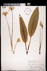 972540[1398090]Janssens, J. 75/351975-04-20 Belgium, Hallebos, 125m |
MIN:Plants | 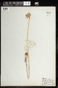 Allium flavum Salisb. 960329[1318846]Heimerl 1923-08-02 Austria |
MIN:Plants | 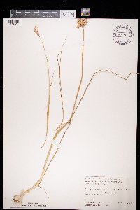 972541[1398091]Janssens, J. 76/721976-06-06 Belgium, La haute roche, IFBL J5 32 33, 180m |
Google Map
Google Maps is a web mapping service provided by Google that features a map that users can pan (by dragging the mouse) and zoom (by using the mouse wheel). Collection points are displayed as colored markers that when clicked on, displays the full information for that collection. When multiple species are queried (separated by semi-colons), different colored markers denote each individual species.